Castlepook’s Tundra Threshold31759 BCE
Around 31,759 BCE, a modern label within late Marine Isotope Stage 3, Ireland was a cold, changing periglacial landscape before the British–Irish Ice Sheet reached its maximum. Derryvree and Greenagho deposits show wetlands and regionally ice-free ground, while pollen, insects and plant remains indicate sparse tundra vegetation. Castlepook Cave preserves MIS 3 fauna including mammoth, reindeer, giant deer, hyaena and Arctic fox, though bone accumulation complicates interpretation. A marked reindeer femur may indicate brief human butchery, not settlement. Lower seas may have eased movement, but routes remained uncertain. Subsequent ice advance buried or destroyed much archaeological evidence across Ireland thereafter.
Dateline
“31,759 BCE” is a modern calendar label, not a date at which an event in Ireland can be identified. It corresponds roughly to 33,708 years before AD 1950, the conventional reference point for “before present” (BP), but neither archaeological deposits nor palaeoclimatic records can distinguish one modern calendar year at this depth of time. The responsible setting is therefore a calibrated range: late Marine Isotope Stage 3 (MIS 3), a fluctuating cold interval broadly dated to c. 59,000–29,000 calibrated years BP. Around the notional year in question, Ireland stood near the threshold of the last great expansion of the British–Irish Ice Sheet, while its surviving evidence comes from cave bones, buried wetlands, pollen, insects, sediments and later scientific re-dating rather than chronicles or settlements.
A Landscape Measured in Ranges
The closest chronological guide comes from deposits beneath later glacial till in County Fermanagh. At Derryvree, near Maguiresbridge, organic silts and fine sands were laid down in freshwater conditions before being overridden by ice. Their radiocarbon determination, Birm-166, was reported as 30,500 radiocarbon years BP with a substantial uncertainty; older calibration placed the deposit broadly within c. 36,900–31,700 calibrated years BP. That wide interval embraces 33.7 thousand years ago. It does not date a single season, settlement or animal death, but it securely shows that a cold, organic-rich wetland existed in north-central Ireland during this portion of the Late Pleistocene, before later ice sealed it beneath till.
Greenagho, also in Fermanagh, supplies a complementary limit. Lacustrine organic material beneath till has been dated to c. 37,200–35,700 calibrated years BP, indicating ice-free ground in that district earlier in MIS 3. Taken together, such records suggest that the Irish ice sheet had not yet attained the island-wide maximum associated with the Last Glacial Maximum. They do not justify a simple map showing all Ireland either white with ice or wholly open. Ice growth was spatially uneven, deposits are patchy, and later glaciers destroyed much of the evidence. The most defensible picture is of a cold, exposed Ireland in transition, with regional conditions changing over millennia rather than on a datable day.
Wetlands, Wind and Sparse Vegetation
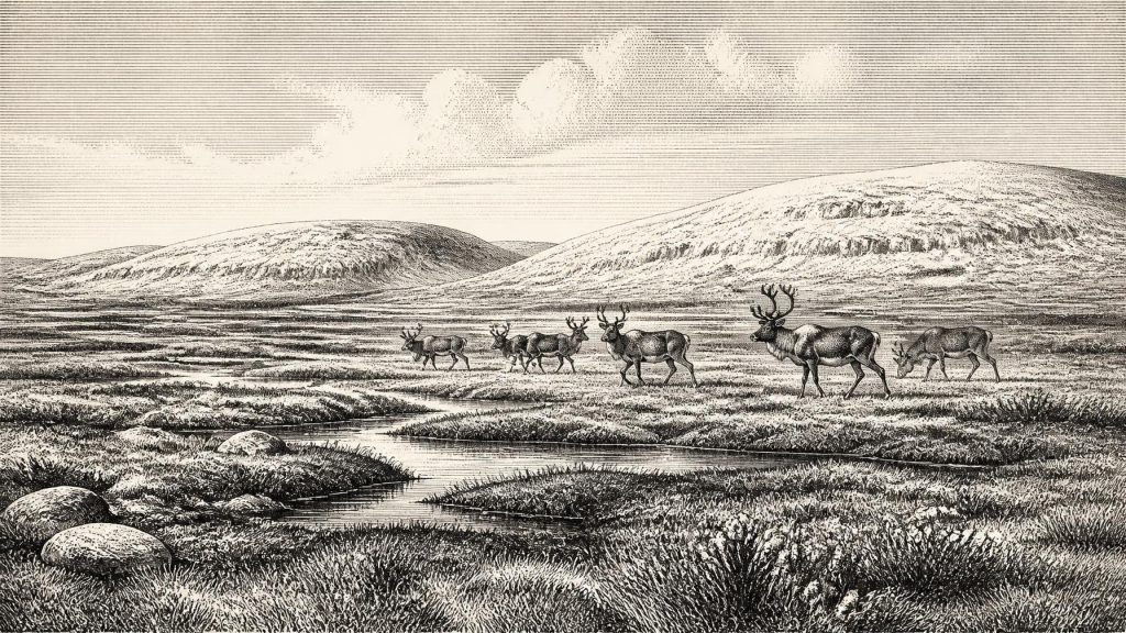
Derryvree’s plant and animal microfossils point to open tundra and a periglacial regime. Mosses, sedges and other low-growing plants could occupy wet ground; beetles and pollen from comparable northern Irish deposits indicate largely treeless, sparsely vegetated landscapes. Aghnadarragh in County Antrim has provided insects associated today with far northern environments, alongside evidence for open ground and little standing water. Palaeoecological reconstructions have suggested cool summers and bitter winters, although such numerical estimates remain models derived from modern species’ climatic tolerances, not direct thermometer readings from ancient Ireland.
This was not necessarily an empty plain of unbroken snow. Periglacial country could include stream margins, shallow pools, sedge-rich hollows, gravelly slopes and more sheltered limestone terrain. Seasonal thaw, freeze–thaw action and strong winds helped move sediment and limited tree growth. The vegetation was likely short and discontinuous, but it could still sustain grazing animals in particular places and seasons. What the environmental evidence demonstrates is habitat, not a fixed view from every valley: a wetland in Fermanagh and a cave catchment in north Cork recorded different local worlds.
Castlepook’s Animal Archive
The richest window on southern Ireland is Castlepook Cave near Doneraile, County Cork, long known in antiquarian accounts as Mammoth Cave. Its deposits and old collections include remains attributed to woolly mammoth, reindeer, giant deer, brown bear, spotted hyaena, wolf, Arctic fox, lemmings and mountain hare. Improved radiocarbon work has revised the chronology of several southern Irish cave specimens, showing that some animals once thought nearer the Last Glacial Maximum were substantially older, within MIS 3. The cave is therefore important evidence that Ireland supported a varied cold-stage fauna before the maximum ice cover.
Yet a cave assemblage is not a census of animals peacefully living together beside its entrance. Carnivores could drag prey and carrion inside; hyaenas could accumulate, gnaw and disperse bone; water could sort material; excavators working between 1904 and 1913 removed deposits by methods far less exact than those used today. Castlepook’s famous galleries preserve a remarkable archive, but their contents must be read taphonomically: by asking how each bone entered, moved within and survived in the cave. Mammoth or hyaena bones prove that those animals reached the wider landscape. They do not alone prove the precise composition, density or seasonality of every herd.
The Human Question
There is no securely excavated village, hearth, cemetery, art site or stone-tool assemblage from Ireland that can be assigned to 31,759 BCE. Consequently there is no basis for describing named communities, family structures, language, leadership, religion or a continuous population at this date. Political affairs, warfare, diplomacy and formal trade are wholly beyond the evidence. Nor should later Irish traditions, medieval origin stories or the familiar monuments of prehistoric Ireland be projected back more than thirty millennia into an entirely different landscape.
A reindeer femur from Castlepook has nevertheless made this period central to the question of Ireland’s earliest human presence. The bone has been reported as about 33,000 years old and bears a deep mark interpreted by zooarchaeologist Ruth Carden as damage made by a stone tool during butchery. If that interpretation is confirmed through further analysis and contextual work, it would indicate a brief Upper Palaeolithic human presence in Ireland vastly earlier than the long-accepted postglacial settlement record. It would not demonstrate permanent colonisation. A butchered bone can record a short visit by mobile hunters as readily as a settled population.
That distinction matters. The modified femur is an important, plausible lead, but it is a single find from an old cave collection rather than a stratified camp with a suite of tools and dated activity surfaces. Recent licensed excavation at Castlepook has sought undisturbed deposits and better contextual evidence. Until those investigations produce and publish a fuller record, the cautious formulation is that humans may have entered Ireland during late MIS 3; their presence around this particular notional year remains unproven. The absence of evidence is partly geological: advancing ice later eroded and buried many former land surfaces.
Routes Across a Changing Northwest
Lower global sea levels during MIS 3 exposed broad areas of what is now continental shelf. This enlarged the terrestrial and coastal landscapes around Ireland, altered river courses and made animal movement from north-western Europe more feasible. It must not, however, be casually converted into a guaranteed dry-shod route. The exact pattern of sea, estuary, lowland and ice changed through time, while Ireland’s insularity depended on local relative sea level as well as global ocean level and the weight of ice depressing the land. For people or animals, movement may have involved a mixture of land corridors, coastal passage and water crossings.
In economic terms, nothing supports trade networks, farming, herding, metalworking or stored surplus in Ireland at this date. If people did visit, their economy would have resembled the highly mobile hunting and scavenging strategies known among Upper Palaeolithic groups elsewhere in north-west Europe: obtaining meat, fat, hides, bone and perhaps seasonal knowledge from an exposed cold-country environment. That is an analogy, not direct Irish evidence. The reindeer femur, if genuinely butchered by people, would support processing of one animal; it cannot reveal how often visitors came, what tools they carried, where they slept or whether they returned.
Before the Main Ice Advance
The larger historical development was environmental transformation. Reconstructions of the British–Irish Ice Sheet show major growth during the interval from roughly 31,000 years ago onwards, followed by maximum expansion later, around c. 27,000–23,000 calibrated years BP. By then ice covered Ireland and extended onto surrounding shelves. The hypothetical moment labelled 31,759 BCE therefore belongs not to a familiar Irish “age” of monuments or peoples, but to the long prelude to that maximum: a world of tundra wetlands, cold-adapted mammals, changing coasts and advancing ice.
Its history is necessarily modest in human terms but substantial in environmental ones. Ireland was not yet the green, wooded island of later millennia, nor an arena for recoverable kingdoms and institutions. It was a northern landscape whose record survives in a handful of exceptional places: silts beneath Fermanagh drumlins, fossils in Cork limestone caves, and the sediments now hidden beneath sea and ice-age deposits. Around 31,759 BCE, the strongest conclusion is not that a particular Irish event occurred, but that the conditions existed in which animals—and perhaps occasional people—could traverse and use a rapidly changing Pleistocene Ireland.
Primary Sources
- A Middle Midlandian Freshwater Series at Derryvree, Maguiresbridge, County Fermanagh, Northern Ireland
- Irish Pleistocene Biostratigraphy
- Trimlines, Blockfields and the Vertical Extent of the Last Ice Sheet in Southern Ireland
- A Reconsideration of the Radiocarbon Dating of the Marine Isotope Stage 3 Fauna from Southern Ireland
- Phylogeographic, Ancient DNA, Fossil and Morphometric Analyses Reveal Ancient and Modern Introductions of a Large Mammal: The Complex Case of Red Deer (Cervus elaphus) in Ireland
- Castlepook Cave
- 2022:564 – Castlepook Cave, Castlepook South, Cork
- Growth and Retreat of the Last British–Irish Ice Sheet, 31,000 to 15,000 Years Ago: The BRITICE-CHRONO Reconstruction
- Pattern and Timing of Retreat of the Last British-Irish Ice Sheet
- Maximum Extent and Dynamic Behaviour of the Last British–Irish Ice Sheet West of Ireland
- Character of Advance and Retreat of the Southwest Sector of the British-Irish Ice Sheet During the Last Glaciation
- Ireland: Submerged Prehistoric Sites and Landscapes
- The Island of Ireland: Drowning the Myth of an Irish Land-Bridge?
- Deglaciation, Earth Crustal Behaviour and Sea-Level Changes in the Determination of Insularity: A Perspective from Ireland
- The IntCal20 Northern Hemisphere Radiocarbon Age Calibration Curve (0–55 cal kBP)
- Dansgaard–Oeschger Events in Climate Models: Review and Baseline Marine Isotope Stage 3 (MIS3) Protocol
- The Marine δ18O Record Overestimates Continental Ice Volume During Marine Isotope Stage 3
- The Colonization of Ireland: A Human Ecology Perspective
- Prehistoric Details: Mell Flint Flake
- New Insights on the Fauna of Ireland’s Younger Dryas and Early Holocene from Alice & Gwendoline Cave
