
The Derryvree Freshwater Archive31572 BCE
Around 31,572 BCE, Ireland lay within the climatically unstable Marine Isotope Stage 3, before maximum expansion of the British–Irish Ice Sheet. At Derryvree, County Fermanagh, freshwater sediments sealed between tills record an ice-free, treeless periglacial wetland of mosses, sedges, insects and shallow water, dated broadly rather than to a single year. Other deposits indicate intermittent milder conditions and regional environmental variation. Castlepook Cave fauna demonstrate cold-adapted animals, while a possibly tool-marked reindeer bone may suggest brief Upper Palaeolithic human contact, though this remains uncertain. No evidence establishes permanent settlement, society or polity. Only ecology survives: ice, habitats and chance preservation.
Dateline
The label 31,572 BCE gives a useful position on a modern timeline, but it cannot identify an event in Irish history. No people in Ireland kept calendars, wrote records or named years at this depth of time. Nor can archaeology resolve an occurrence to this individual year. The responsible approach is to locate it within broad, calibrated chronological ranges. In radiocarbon terms, 31,572 BCE falls at roughly 33,500 years before AD 1950, within Marine Isotope Stage 3 (MIS 3), a long, climatically unstable part of the last glacial cycle. Ireland was not yet uniformly buried beneath the great ice sheet that would later dominate the landscape. Instead, the evidence points to a cold, changing country in which local ice-free ground, wetlands, open vegetation and animal habitats existed alongside advancing ice.
A Date Within a Range
The closest particularly relevant Irish environmental record is at Derryvree, near Maguiresbridge in County Fermanagh. Road works in 1969 cut through a drumlin and revealed organic silts and fine sands trapped between two thick layers of till, the unsorted debris left by glacier ice. The intervening freshwater sediments were dated to 30,500 radiocarbon years BP, with a substantial uncertainty of about 1,100 years. Published calibrations place the deposit broadly between about 36,900 and 31,700 calibrated years BP. The notional year 31,572 BCE lies within that wide interval, but cannot be pinned to a particular layer, season or episode within it.
This distinction matters. Derryvree demonstrates that its locality was ice-free when the freshwater deposit accumulated, after one glacial episode and before another. It does not show that every part of Ireland was simultaneously ice-free, nor does it establish a stable national climate lasting centuries. A dated organic layer represents accumulated biological material, not a diary entry. The sample supplies a chronological window; the plant, insect and sediment evidence supplies a picture of the conditions within that window. Later ice both protected some fragments of this record beneath till and obliterated much else, which is one reason Ireland’s evidence for this period is sparse and difficult to interpret.
Freshwater Beneath the Drumlin
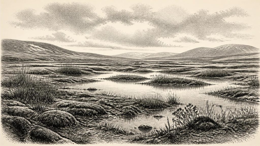
The Derryvree deposits describe a treeless, periglacial freshwater environment. Pollen was dominated by herbaceous plants, while plant macrofossils, mosses and insects added detail unavailable from pollen alone. The original investigators interpreted the setting as open tundra and muskeg: wet, peaty or mossy ground, shallow pools and waterlogged margins in a climate marked by severe cold and seasonal freezing. Sedges and other low vegetation could flourish where moisture and the short growing season allowed, but this was not woodland and should not be imagined as a familiar Irish bog or pasture.
Such evidence speaks most securely about local ecology. It shows that living plants, freshwater and invertebrates occupied an exposed Fermanagh landscape during the deposit’s formation. It also implies soils subject to frost, limited shelter and a growing season far shorter than that of modern Ireland. The landscape was dynamic. Fine sand suggests moving water or wind-blown sediment, while the enclosing tills record repeated reorganisation by ice. Derryvree therefore preserves not a timeless ‘Ice Age Ireland’, but a relatively habitable interlude within a fluctuating glacial world.
Other Irish records reinforce the broader point without making the chronology exact. Under till at Greenagho, also in Fermanagh, organic lake deposits indicate a pre-Last Glacial Maximum ice-free phase. In south-west Ireland, uranium-thorium dates from broken and reworked speleothems in Crag Cave show that calcite sometimes formed during MIS 3. Because cave calcite needs liquid water, these episodes are evidence for intervals when local mean annual conditions were sufficiently mild for water to circulate through the shallow cave system. They do not mean that Ireland was warm, forested or continuously hospitable; rather, they reveal millennial-scale climatic oscillation across the island.
Ice Building Around an Open Landscape
At this date, the British–Irish Ice Sheet was developing, but its growth was neither simple nor synchronous. Recent BRITICE-CHRONO reconstructions begin at 31,000 years BP because older constraints are sparse. Their model depicts early ice accumulation over parts of Ireland, northern Britain and Shetland, followed by major expansion towards a maximum areal extent around 26,000 years BP. Geological evidence and modelling indicate that sea level across the wider region was markedly lower than today, perhaps 50 to 100 metres below present at around 31,000 BP. Yet a low sea surface is not proof of an easy, continuous walking route from Ireland to Britain or continental Europe: coastlines, channels, exposed shelves and glacier margins changed through time, and the exact configuration relevant to any journey remains uncertain.
The central historical fact is regional variation. Derryvree’s freshwater lens means that north-central Ireland cannot be treated as a featureless ice cap throughout the period represented by its date range. Conversely, the record does not permit a map of safe routes, settled districts or an island-wide animal census. As glaciers grew, they altered drainage, stripped sediments and redirected rivers; they also left the drumlins, tills and erratics that now structure much of Ireland’s physical geography. Around 31,572 BCE, the future glacial transformation was under way, even where a wetland still supported mosses, sedges and insects.
Animals and the Castlepook Question
Southern Irish cave collections offer another, more dramatic line of evidence. Castlepook Cave near Doneraile, County Cork, formerly known as Mammoth Cave, has yielded remains of reindeer, woolly mammoth, spotted hyaena, brown bear, wolf, fox, hare and other Ice Age animals. Modern redating has shown that several specimens in older collections are considerably older than the radiocarbon ages obtained in the 1990s, placing important parts of the fauna in MIS 3. The assemblage confirms that Ireland supported, or was visited by, cold-adapted and open-country animals during this broad period. It cannot demonstrate that every listed species lived together at one moment, since cave assemblages may combine deposits of different ages and origins.
A reindeer femur from Castlepook has made this timespan especially significant for the human history of Ireland. County Cork heritage material dates it to about 31,000 BC and identifies a deep linear mark which zooarchaeologist Ruth Carden interprets as having been made by a sharp stone tool while fresh bone was being processed. If that interpretation is correct, it would be evidence that people handled a reindeer in Ireland during the Upper Palaeolithic, many millennia earlier than the securely dated terminal-Pleistocene human trace from Alice and Gwendoline Cave in County Clare.
But the proper conclusion remains cautious. The Castlepook femur was recovered during antiquarian cave excavations, not from a modern, sealed excavation alongside a directly associated hearth, stone-tool assemblage or dwelling floor. Radiocarbon dating establishes the age of the animal bone, not necessarily the precise time or maker of the surface modification. Carnivore damage, sediment movement, weathering and old excavation practices all complicate interpretation. The object is important evidence under active reassessment, not proof of a permanent colony, a named hunting band or a settled population in Ireland in 31,572 BCE.
People: Possibility, Not a Polity
There is no evidence for political affairs, diplomacy, leaders, territorial states or organised warfare in Ireland at this date. There is equally no basis for describing an Irish tribe, language, religion, trade network or artistic tradition. Those absences are not trivial gaps in an otherwise complete story: they are the principal condition of the evidence. Even if the Castlepook mark proves to be human-made, it would support a short-lived encounter with a carcass, perhaps by a very small mobile party, rather than a reconstruction of society on the island.
Comparisons with Upper Palaeolithic groups elsewhere in north-west Europe can nevertheless clarify what is plausible without turning analogy into fact. Such communities were highly mobile hunter-gatherers who made stone tools, managed clothing and shelter in cold conditions, and maintained social connections across wide areas. Reindeer were a valuable resource for meat, hides, sinew, antler and bone. But none of those behaviours has yet been directly demonstrated in Ireland at this age. No indisputable Irish lithic workshop, camp, hearth, grave, ornament, painted cave or ritual deposit belongs to around 31,572 BCE. The evidence supports the possibility of brief visits; it does not yet establish repeated occupation.
The difference between evidence and interpretation has sharpened with work at Irish caves. The directly dated, cut-marked brown-bear patella from Alice and Gwendoline Cave belongs much later, around 12,810–12,590 calibrated BP, and is often presented as the first firm Palaeolithic human presence in Ireland. Subsequent excavation also found that much of the cave sediment had entered through openings by runoff or slope movement rather than accumulating as an intact habitation floor. That research is a salutary guide for the deeper past: bones may preserve remarkable clues, but cave formation processes must be understood before social conclusions can be drawn.
A Landscape Before the Great Advance
The most vivid supportable scene for Ireland around this notional year is therefore environmental rather than political. In the Derryvree area, low vegetation and mossy wet ground fringed pools and slow water beneath a cold, open sky. Elsewhere, animals adapted to cold grassland and tundra-like habitats moved through landscapes whose precise connectivity is unknown. In the south, caves could trap bones brought in by carnivores, water or human activity; far offshore and on uplands, expanding ice was reshaping the conditions of life.
It would be misleading to call this a beginning of continuous Irish settlement. The archaeological record does not support that claim. Yet it is not a blank page either. Derryvree’s buried freshwater bed, Castlepook’s fauna and the wider reconstruction of the growing British–Irish Ice Sheet show that Ireland had ecological histories long before farming, monuments, metalwork or written names. At 31,572 BCE, the island’s story is one of precarious habitats, changing ice margins and evidence preserved by chance: a freshwater world sealed beneath a drumlin, awaiting the much later tools needed to read it.
Primary Sources
- A Middle Midlandian Freshwater Series at Derryvree, Maguiresbridge, County Fermanagh, Northern Ireland
- A Reconsideration of the Radiocarbon Dating of the Marine Isotope Stage 3 Fauna from Southern Ireland
- Trimlines, Blockfields and the Vertical Extent of the Last Ice Sheet in Southern Ireland
- Exploring Controls of the Early and Stepped Deglaciation on the Western Margin of the British-Irish Ice Sheet
- Timing, Pace and Controls on Ice Sheet Retreat: An Introduction to the BRITICE-CHRONO Transect Reconstructions of the British-Irish Ice Sheet
- Growth and Retreat of the Last British-Irish Ice Sheet, 31,000 to 15,000 Years Ago: The BRITICE-CHRONO Reconstruction
- Timing and Pace of Ice-Sheet Withdrawal Across the Marine-Terrestrial Transition West of Ireland During the Last Glaciation
- Extent and Deglacial Chronology of the Last British-Irish Ice Sheet: Implications of Exposure Dating Using Cosmogenic Isotopes
- Pattern and Timing of Retreat of the Last British-Irish Ice Sheet
- New Data for the Last Glacial Maximum in Great Britain and Ireland
- Episodic Speleothem Deposition Tracks the Terrestrial Impact of Millennial-Scale Last Glacial Climate Variability in SW Ireland
- The Irish Quaternary Fauna Project
- First Evidence of a Late Upper Palaeolithic Human Presence in Ireland
- New Insights on the Fauna of Ireland’s Younger Dryas and Early Holocene from Alice & Gwendoline Cave
- Heritage Artefacts of County Cork
- The Mesolithic in Ireland: When Was It?
- Palaeoecology
- Figure 6.— The Subdivision of the Quaternary Period in Ireland
- Stratigraphic and Palaeo-Geomorphological Evidence for the Glacial-Deglacial History of the Last British-Irish Ice Sheet in the North-Western Irish Sea
- Could Brown Bears (Ursus arctos) Have Survived in Ireland During the Last Glacial Maximum?
