
The Maguiresbridge Freshwater Bed31315 BCE
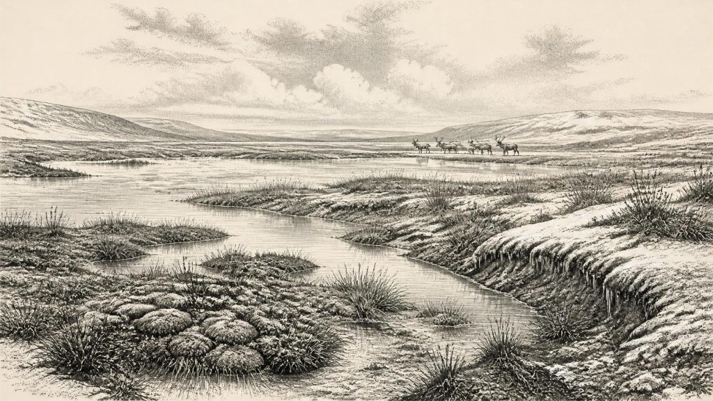
Around 31,315 BCE, the landmass that became Ireland lay within an unstable Late Pleistocene glacial landscape, not a defined country. Derryvree, County Fermanagh, preserves freshwater sediments between tills, dated broadly to this period, indicating treeless tundra wetlands, seasonal thaw and later renewed ice. Castlepook Cave, County Cork, contains a long-lived assemblage of mammoth, giant deer, reindeer, bear, hyaena and other cold-climate fauna, demonstrating intermittent ecological richness but not a single contemporary community. A possibly cut-marked reindeer bone may indicate transient human activity, yet no secure occupation evidence survives. Evidence supports environmental change, not settled populations, institutions or precise annual history.
Dateline
Modern calendar-year precision is not available for Ireland in 31,315 BCE. This numbered year is best understood as an approximate point about 33,300 calendar years before AD 1950, within the Late Pleistocene and Marine Isotope Stage 3 (MIS 3), a long, cold and climatically unstable part of the last glacial cycle. No written record, annual archaeological layer, named community or securely dated human episode allows historians to describe this moment as though it were a later year in Irish history. The responsible evidence consists instead of sediment layers, fossil plants, animal bones, cave deposits and reconstructions of changing ice margins. Their dates are ranges, not anniversaries.
An Island Not Yet Fixed
“Ireland” in this remote context means the landmass that would become the modern island, not a country with recognised borders, a people, or a political identity. Coastlines differed as global sea levels were lower, and the surrounding shelves, shallow seas and ice margins changed repeatedly. Yet it would be misleading to turn lower sea level into a simple land-bridge story. The geography of routes between Ireland, Britain and continental Europe was variable and imperfectly known; the existence of Ice Age mammals in Ireland shows that dispersal occurred during parts of the wider period, but does not identify a particular crossing, season or route.
The date falls before the later maximum of the British–Irish Ice Sheet. Modern reconstructions show that the sheet did not grow in one smooth movement or reach its greatest extent everywhere simultaneously. Its later maximum volume is placed around 23,000 years before present, while different sectors advanced and retreated at different times. Evidence from Ireland indicates a long build-up from roughly the mid-30,000s to the mid-20,000s years before present. Around 31,315 BCE, therefore, the landscape should be envisaged as unstable and regionally varied: some ground had been, or was becoming, affected by advancing ice, while other places retained cold, ice-free environments.
This matters because the popular image of an entirely white, permanently frozen Ireland is too simple. Conversely, no evidence supports a temperate, wooded island. The surviving records point instead towards exposed, treeless terrain shaped by frost, short growing seasons, shifting watercourses and glacial change. Later ice repeatedly eroded, buried and rearranged older deposits, which is why the evidence is so uneven. The sites that survive are rare windows rather than a complete map of the island.
Derryvree’s Buried Evidence
The most important Irish environmental record relevant to this date lies at Derryvree, near Maguiresbridge in County Fermanagh. Roadworks in 1969 cut through a drumlin and exposed freshwater silts and fine sands enclosed between two deposits of till, the unsorted material laid down by glacier ice. The sequence is unusually informative. The lower till records glacial conditions; the sediments above it accumulated during an interval without ice at that locality; and the upper till demonstrates that ice later returned or expanded across the site. It is a stratigraphic record of change, not a snapshot of one year.
Organic material from the Derryvree deposit produced a radiocarbon determination of 30,500 ± roughly 1,100 radiocarbon years before present. Calibration converts this into a broad range of approximately 36,900–31,700 calibrated years before present. The calendar label 31,315 BCE falls within that span, but the range must not be mistaken for proof that every part of the deposit, much less every part of Ireland, dates to that exact year. Radiocarbon measures the age of sampled carbon; calibration accounts for past variation in atmospheric radiocarbon. At this depth in time, uncertainty spanning centuries or millennia is normal.
What the Derryvree evidence does establish is striking. Pollen, mosses, plant macrofossils and small-animal remains indicate a full-glacial or periglacial freshwater setting with open tundra vegetation. The older word muskeg has often been used for its wet, moss-rich character, though it should not conjure a modern peat bog unchanged through time. Shallow pools, silts, sedges, mosses, herbs and sparse low-growing plants formed a waterlogged landscape. Dry ground was probably limited and vegetation thin in places. A few tree-pollen grains do not demonstrate nearby forest: such grains can travel far, and the wider botanical assemblage points decisively to treeless country.
Derryvree thus provides evidence for seasonality as well as cold. Summer thaw could sustain wetland plants, insects and grazers around sheltered water, whereas prolonged frost and winter darkness sharply constrained biological productivity. These are environmental interpretations founded on fossils and sedimentary context, not direct observations of temperature, snowfall or a particular day’s weather. Nor should Derryvree be universalised. It reveals an inland Fermanagh wetland during part of a lengthy interval between glacial episodes; Cork, Atlantic coasts, uplands and the Irish Sea basin may have had materially different conditions.
Animals in the Limestone Caves
County Cork supplies the other major body of evidence. Castlepook Cave, near Doneraile, is Ireland’s richest known site for vertebrate fauna from the period leading towards the Last Glacial Maximum. Excavations in the early twentieth century recovered more than 2,000 bones from its maze of limestone passages and chambers. Later reassessment and improved radiocarbon methods have made clear that the cave collection covers a long period, rather than one neatly contemporaneous animal community. Individual remains have dates ranging from about 45,700 to 19,950 years before present.
Its fauna includes woolly mammoth, giant deer, reindeer, brown bear and spotted hyaena; later cold-stage material includes wolves, Arctic foxes, mountain hares and lemmings. The assemblage is powerful evidence that parts of Ireland could at times support, or be reached by, a varied cold-climate mammal fauna. It also suggests open landscapes able to sustain large herbivores and their predators. But the cave was a repository, not a census. Carnivores could carry prey remains inside; water disturbed some deposits; and bones from separate centuries or millennia can become associated in one excavation collection. It cannot prove that every listed animal lived together near Castlepook in 31,315 BCE.
A reindeer femur from Castlepook has particular importance for the human story. A deep mark on it has been interpreted as an incision made on fresh bone with a sharp stone edge, potentially during carcass processing. If that interpretation is confirmed, it would be evidence of a brief Upper Palaeolithic human encounter with a reindeer in Ireland during MIS 3. It would not establish a settled population, a camp, a hunting territory, or continuous ancestry linking such visitors to later Irish people. The bone’s cave context and the distinction between a dated animal and an identified human action require continuing caution.
Recent work at Castlepook has sought surviving, undisturbed Pleistocene deposits and definitive cultural evidence. The 2022 excavation confirmed that deposits remain in parts of the cave, but reported no stone tools, hearths, dwelling traces or other secure evidence of occupation. That negative result is significant. Ireland at this horizon cannot responsibly be furnished with a named society, a permanent settlement network or a developed local Palaeolithic tradition. The possibility of short visits by highly mobile people remains a research question, not a licence for confident narrative.
No Polities, but Ecological Pressures
There is no evidence for political affairs, diplomacy, formal warfare, rulers, territories or collective institutions in Ireland at this time. There are likewise no known farms, fields, domestic animals, monuments, graves, shrines, metal objects, writing or market places. Such absences are not merely gaps in a familiar historical record: they reflect the very different scale of surviving evidence. Archaeology can identify a wetland, a cave fauna and perhaps a modified bone; it cannot recover constitutions or kinship rules from them.
Conflict is best considered ecologically rather than politically. Carnivores, especially spotted hyaenas, were competitors and scavengers within a harsh food web. If people visited Ireland, they would have faced the same basic pressures as other Upper Palaeolithic groups in north-west Europe: securing food, fuel, shelter, hides and workable stone while navigating dangerous animals and volatile weather. This is a reasonable comparison, not direct proof of their practices in Ireland. The Castlepook evidence does not show a hunt, and a cut-marked limb would not reveal whether an animal had been killed, scavenged, or processed elsewhere.
Nor can religion, art, language, teaching or ritual be recovered for this year. There is no Irish cave art or portable art securely attributable to the Derryvree–Castlepook horizon, and no material basis for assigning beliefs to either possible visitors or the wider animal landscape. Human learning, if people were present, would have been embodied in skills such as movement, animal knowledge, tool use and survival in cold conditions. Yet even that is an inference from the broader Upper Palaeolithic world, not an excavated Irish curriculum.
A Narrow Historical Horizon
The economy detectable in Ireland was ecological. Wetland plants converted the brief growing season into biomass; herbivores exploited open country; predators and scavengers followed them. Animal movement may have connected Ireland with neighbouring lands at intervals, but evidence does not demonstrate organised trade or exchange. A hypothetical human visitor could have valued reindeer meat, hide, sinew, antler and bone, but none of these possible uses can be assigned to a known group at Maguiresbridge or Castlepook.
The most important development around 31,315 BCE was therefore not political but environmental: Ireland occupied a changing northern fringe of the last glacial world, with ice expansion increasingly transforming the opportunities available to plants, animals and any passing people. Derryvree preserves the freshwater, treeless side of that world; Castlepook preserves its mammalian side. Together they show that pre-maximum Ireland was neither empty of life nor legible as a settled human country. Its history at this depth is a history of calibrated ranges, fragmentary deposits and carefully limited conclusions.
Primary Sources
- A Middle Midlandian Freshwater Series at Derryvree, Maguiresbridge, County Fermanagh, Northern Ireland
- Palaeoecology
- The Subdivision of the Quaternary Period in Ireland
- Castlepook Cave: Cork County Geological Site Report
- A Reconsideration of the Radiocarbon Dating of the Marine Isotope Stage 3 Fauna from Southern Ireland
- Growth and Retreat of the Last British–Irish Ice Sheet, 31,000 to 15,000 Years Ago: the BRITICE-CHRONO Reconstruction
- Growth and Retreat of the Last British–Irish Ice Sheet, 31,000 to 15,000 Years Ago: the BRITICE-CHRONO Reconstruction
- Trimlines, Blockfields and the Vertical Extent of the Last Ice Sheet in Southern Ireland
- Late Pleistocene Chronostratigraphy and Ice Sheet Limits, Southern Ireland
- Quaternary Deposits and Glacial Stratigraphy in Ireland
- Quaternary Geological Map of Ireland 1:500,000 Scale
- Geological Survey Ireland Quaternary Data Services
- 2022:564 – Castlepook Cave, Castlepook South, Cork
- Castlepook Caves
- Heritage Artefacts of County Cork
- Prehistoric Details
- UCD School of Archaeology Research Day 2022
- Deglaciation Chronology of the Donegal Ice Centre, North-west Ireland
- Timing and Pace of Ice-sheet Withdrawal Across the Marine–Terrestrial Transition West of Ireland During the Last Glaciation
- The Geology of the Irish Sea: UK Offshore Regional Report
- Investigating Seasonal Mobility in Irish Giant Deer (Megaloceros giganteus Blumenbach) Using Strontium Isotope Analysis
- The Irish Quaternary Fauna Project
