

Derryvree’s Interrupted Waters31079 BCE
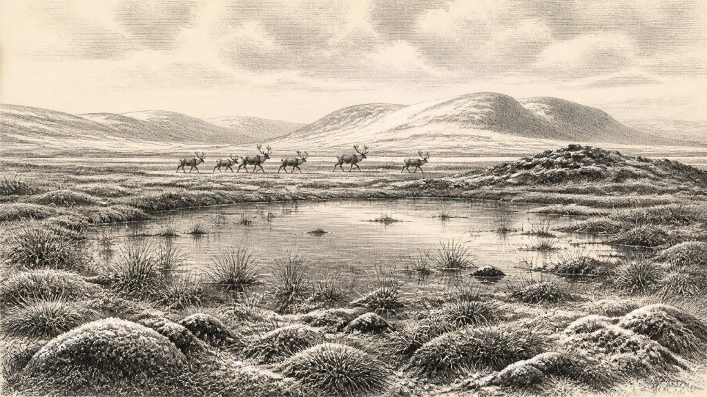
Around 31,079 BCE, Ireland cannot be reconstructed as a year-specific historical setting. Derryvree, County Fermanagh, preserves freshwater sediments between glacial tills, indicating a locally ice-free, cold wetland landscape during late MIS 3, although its broad dates cannot define island-wide conditions. Vegetation suggests open tundra-like terrain with pools, sedges and hardy plants. Castlepook Cave, County Cork, contains a long, mixed faunal record including mammoth, reindeer, predators and lemmings. A possibly stone-cut reindeer femur raises, but cannot confirm, brief Upper Palaeolithic human presence. Later glacial expansion repeatedly buried or destroyed evidence across the island, requiring cautious interpretation of Ireland’s shifting ecological frontier.
Dateline
31,079 BCE is not a year that can be recovered as a historical moment in Ireland. No written calendar, settlement sequence or datable human action allows archaeologists to identify events within these particular twelve months. The label is a modern conversion, approximately 33,000 calendar years before AD 1950, within the Late Pleistocene and Marine Isotope Stage 3 (MIS 3). At such depth, dates are expressed as ranges and probabilities, not anniversaries. Ireland can be illuminated by glacial sediments, fossil plants, animal bones and cave deposits, but these record environmental intervals and episodes of deposition rather than a chronicle of a named year.
A Date Within a Long Cold Stage
The closest useful Irish evidence is the Derryvree deposit near Maguiresbridge, County Fermanagh. Roadworks in 1969 cut through a drumlin and revealed freshwater silts, fine sands and organic material sealed between two layers of till: the unsorted debris laid down by glacier ice. The order is decisive evidence. Ice had crossed the district before the freshwater sediments accumulated; a later ice advance then covered and preserved them. Derryvree therefore proves substantial environmental change through the last glacial cycle, rather than a permanently frozen Ireland.
Organic material from the deposit yielded the conventional radiocarbon determination BIRM-166, about 30,500 radiocarbon years BP, with a large uncertainty. A radiocarbon measurement is not a calendar date. Atmospheric carbon-14 has varied through time, and measurements must be calibrated using internationally maintained curves. With the original laboratory uncertainty and the uneven shape of calibration curves at this age, the relevant calendar range is broad: Derryvree is generally placed within a late MIS 3 interval of roughly 36,900–31,700 calibrated years BP. The requested date lies within that wide horizon, but it cannot be attached to a particular pool, plant, animal or season at the site.
That distinction matters. The Derryvree sediments are powerful evidence for a local ice-free freshwater environment between glacial advances. They are not proof that all Ireland was ice-free at once, nor do they show what happened everywhere on the island. Much of the older Pleistocene ground surface has been eroded, buried or rearranged by later ice. The rarity of surviving evidence is itself part of the story: Ireland’s deep past has been repeatedly edited by glaciers.
Wet Ground and Open Country
The plants, pollen and invertebrate evidence from Derryvree point to a cold, open and largely treeless landscape. Mosses, sedges, grasses and hardy Arctic-alpine plants grew around shallow water and saturated ground. Bogbean, water-milfoil and other wetland taxa indicate that freshwater was present, while dwarf shrubs and herbs speak to exposed land nearby. This was not the familiar Ireland of oak woods, hedged fields and pasture. It was a periglacial mosaic of marshy hollows, open pools, sedge beds, frost-affected soil and sparse vegetation, shaped by a short growing season and severe winters.
Such a reconstruction should not be made too neat. A plant assemblage does not provide a weather diary, and one Fermanagh basin cannot stand for every coast, valley and upland. Nevertheless, it demonstrates a functioning ecosystem rather than an unbroken sheet of ice. Water could pond behind local barriers; plants could establish in sheltered or wet places; insects and small animals could occupy suitable niches. The term often used for comparable waterlogged terrain is muskeg, but the important point is variability: cold, wet ground and open vegetation coexisted with rapidly changing ice margins.
Climate across the North Atlantic was unstable during MIS 3. Greenland ice-core records show abrupt alternations between relatively milder interstadials and markedly colder stadials. Ireland lay on the Atlantic edge of this volatile system. Conditions at Derryvree were cold enough to support tundra-like vegetation, yet sufficiently non-glacial, at least locally and temporarily, for freshwater sediment and organic matter to accumulate. The evidence supports environmental fluctuation, not a simple progression from warmth to cold.
Before the Greatest Ice Expansion
At about 33,000 calendar years BP, Ireland was approaching the fuller development of the last British–Irish Ice Sheet, not living at its later maximum extent. The best large-scale reconstructions place the major last-glacial advance and maximum ice-sheet area later, with maximum extent around 26,000 years BP and maximum volume around 23,000 years BP. Different sectors advanced and retreated at different times, so these figures should not be turned into a single island-wide date. Yet they make one broader point secure: the Ireland of this article belonged to an unstable pre-maximum world, in which ice, periglacial terrain and ice-free refuges were changing their relative reach.
The eventual expansion was transformative. Glaciers stripped soil, deepened valleys, redistributed rock and sediment, and formed or reshaped many of the drumlins, moraines and meltwater channels that remain prominent in the Irish landscape. At Derryvree, the upper till physically sealed the older wetland. What is now evidence for environmental life survived precisely because subsequent ice buried it. Across other areas, however, erosion may have erased the places where animals fed, predators denned or people might briefly have camped.
Castlepook’s Faunal Archive
County Cork offers a different kind of evidence. Castlepook Cave, also called Mammoth Cave, lies in the Awbeg valley near Doneraile. Its early twentieth-century excavations recovered more than 2,000 bones and made it Ireland’s richest known archive of vertebrate life leading up to the Last Glacial Maximum. Direct dates show that the assemblage accumulated across a very long interval, broadly from about 45,700 to 19,950 years BP. It must therefore not be treated as a single simultaneous animal community, or as a snapshot of 31,079 BCE.
Even so, the list of animals is striking. Castlepook has produced remains attributed to woolly mammoth, giant deer, reindeer, brown bear, wolf, Arctic fox, lemmings and spotted hyaena. Together, they establish that parts of Ireland at different times within the middle and later Ice Age could support large herbivores, predators and cold-adapted smaller mammals. Reindeer and lemmings fit an open, northern environment; mammoth and giant deer point to productive grazing landscapes at least episodically. Spotted hyaena is especially significant, because the cave probably served in part as a carnivore den or a place to which scavengers carried bone.
That last qualification is essential for interpreting everyday life in the Ice Age. A cave bone does not necessarily mark the place where an animal died. Carcasses or portions of carcasses could have been transported by predators, water or people; older excavations also lacked the stratigraphic methods expected today. The Castlepook remains show which species reached Ireland and occupied its landscapes over long periods. They do not demonstrate a stable, fully known food web in a single generation, still less a settled community beside the cave.
The Reindeer Femur Question
One Castlepook object has brought the human question into sharp focus: a reindeer femur bearing a deep linear mark interpreted by zooarchaeologist Ruth Carden as damage made by a stone tool during butchery. Public heritage accounts place the bone broadly at about 31,000 BC, close enough to this article’s notional date to be highly relevant. If the mark is confirmed as anthropogenic, it would be evidence that someone processed a reindeer in Ireland during the Upper Palaeolithic, far earlier than the long-established post-glacial record of human presence.
The evidence should neither be dismissed nor enlarged beyond what it can bear. The dated bone identifies when the animal lived, not the exact instant of cutting. The cave contains material accumulated over many millennia and subject to carnivore activity, water movement and old excavation. No securely associated stone-tool assemblage, hearth, shelter floor, human remains, burial, ornament or repeated concentration of food waste has been recovered for this episode. A cut-marked femur could reflect a brief visit or carcass-processing event; it cannot demonstrate a permanent population, a village or a regular Irish hunting territory.
If people did reach the island, their most plausible livelihood would have involved mobility and close attention to animal movements, weather and usable routes through a cold North Atlantic landscape. A reindeer carcass could yield meat, marrow, hide, sinew, bone and antler. But those are general possibilities, not details proven for Castlepook. There is no Irish evidence at this date for the group’s numbers, language, clothing, social organisation or place of origin. Nor can the evidence show whether people killed the animal, scavenged it, or processed it elsewhere before a carnivore carried part of it into the cave.
No Politics, No Proven Settlement
For this date there is no responsible basis for discussing Irish rulers, territories, diplomacy, organised warfare, formal religion, monuments, farming, trade or learning as though they were known institutions. There were no states or written records, and no securely demonstrated resident human community from which such institutions could be inferred. Even the possibility of human presence rests on one important but limited artefact claim. The primary historical subject is therefore landscape and evidence: freshwater between ice advances, mobile animal populations, carnivore activity and the possibility of a fleeting human encounter with that world.
Culture and knowledge are equally beyond direct recovery in Ireland. Upper Palaeolithic communities elsewhere in Europe used sophisticated stone technologies, fire, tailored clothing and wide social connections. Those comparisons establish what contemporary humans were capable of, but they cannot be imported as Irish facts. Ireland has not yielded securely dated art, personal ornaments, lithic workshops or domestic structures for around 33,000 years ago. The absence may reflect real rarity, later glacial destruction, the limited search for surviving deposits, or all three.
An Island at the Edge of Evidence
The most vivid responsibly supported picture is thus not of a prehistoric nation but of a shifting ecological frontier. Around the modern date-label 31,079 BCE, parts of Ireland experienced cold, open landscapes with wetlands and freshwater pools; animals including reindeer and formidable predators moved through suitable terrain over the broader period; and ice was an active force whose later expansion would bury and destroy much of the record. Derryvree and Castlepook are complementary archives: one preserves a wetland between tills, the other a long and complicated accumulation of animal remains.
For Ireland at this depth of time, restraint is not a lack of history. It is the method that allows a compelling history to emerge. The sediments demonstrate a cold but living landscape. The faunal record demonstrates repeated animal occupation. The marked reindeer femur raises, but does not settle, the prospect of an early human visit. Everything more precise than that—including a year-specific event in 31,079 BCE—would be invention rather than archaeology.
Primary Sources
- A Middle Midlandian Freshwater Series at Derryvree, Maguiresbridge, County Fermanagh, Northern Ireland
- Freshwater Organic Deposits and Stratified Sediments Between Early and Late Midlandian (Devensian) Till Sheets, at Aghnadarragh, County Antrim, Northern Ireland
- A Reconsideration of the Radiocarbon Dating of the Marine Isotope Stage 3 Fauna from Southern Ireland
- The Irish Quaternary Fauna Project
- Castlepook Cave
- Heritage Artefacts of County Cork
- Growth and Retreat of the Last British–Irish Ice Sheet, 31,000 to 15,000 Years Ago: The BRITICE-CHRONO Reconstruction
- Trimlines, Blockfields and the Vertical Extent of the Last Ice Sheet in Southern Ireland
- Timing and Pace of Ice-Sheet Withdrawal Across the Marine–Terrestrial Transition West of Ireland During the Last Glaciation
- The Deglaciation of the Western Sector of the Irish Ice Sheet from the Inner Continental Shelf to its Terrestrial Margin
- Stratigraphic and Palaeo-Geomorphological Evidence for the Glacial-Deglacial History of the Last British-Irish Ice Sheet in the North-Western Irish Sea
- A Critical Review and Re-Investigation of the Pleistocene Deposits at Blackhall Wood, County Kildare, Ireland
- The Subdivision of the Quaternary Period in Ireland
- The IntCal20 Northern Hemisphere Radiocarbon Age Calibration Curve (0–55 cal kBP)
- The IntCal20 Approach to Radiocarbon Calibration Curve Construction: A New Methodology Using Bayesian Splines and Errors-in-Variables
- IntCal Publications
- Mammoth Cave
- Areas of Scientific Interest in County Cork
- Archaeology Research Excavation Grant Report 2023: Castlepook Cave
- Castlepook Cave, Co. Cork, 2022
- New Insights on the Fauna of Ireland’s Younger Dryas and Early Holocene from Alice & Gwendoline Cave
- Dimensions and Chronology of the Last Ice Sheet in Western Ireland








