
Derryvree’s Menyanthes Bed30938 BCE
Around 30,938 BCE, Ireland lay within the climatically unstable Late Pleistocene MIS 3, with no evidence of political societies or permanent human settlement. Derryvree, County Fermanagh, preserves sediments between glacial tills, recording an ice-free wetland of grasses, sedges, juniper, bogbean and other cold-adapted plants. Insects confirm waterlogged, treeless conditions. Crag Cave indicates intermittent warmer phases, while later ice expansion reshaped and obscured landscapes. Castlepook Cave yielded cold-stage animal remains, including reindeer, mammoth and hyaena, though deposits are mixed and dates uncertain. A possibly cut-marked reindeer bone suggests unconfirmed human visitation. Surviving evidence depicts changing tundra ecosystems, not recorded events alone.
Dateline
Modern calendar precision is not available for Ireland at this depth in time. “30,938 BCE” is a useful modern label, roughly 32,887 calendar years before AD 1950, not a date that anyone living then recognised or that archaeology can resolve into a single season, event or generation. The responsible setting is the Late Pleistocene, within Marine Isotope Stage 3 (MIS 3), a long and climatically unstable part of the last Ice Age. Around this broad horizon, Ireland’s history is environmental rather than political: the evidence consists of buried sediments, fossil plants, insects, cave bones and changing ice margins, not written records, settlements or named peoples.
That distinction matters. There is no basis for describing an Irish government, tribe, war, diplomacy, religion or established culture in this particular year. Nor is there secure evidence for a permanent human community on the island. What can be reconstructed, cautiously, is a changing northern landscape in which ice, water, frost and mobile animals repeatedly altered the possibilities for life. The best evidence is local and discontinuous, but it establishes that parts of Ireland could support living ecosystems during MIS 3 before the far more extensive glaciation of the Last Glacial Maximum.
A Number Within Deep Time
The Late Pleistocene chronology requires care. Radiocarbon ages are conventionally expressed as years “before present”, where present means AD 1950; they are not direct calendar ages. Changes in atmospheric carbon-14 mean that a laboratory determination must be calibrated against independent records, and the result is normally a probability range rather than one exact year. At more than 30,000 years ago, those ranges can be broad. Accordingly, 30,938 BCE should not be treated as the date of a specific Irish archaeological occurrence, but as a point within an interval of major environmental change.
The island’s relevant archaeological-period label is Upper Palaeolithic Europe, but that label must not be mistaken for proof of an Upper Palaeolithic settlement in Ireland. In continental Europe and Britain, people of this era were mobile hunter-gatherers using stone, bone and antler technologies, with rich evidence of camp sites, hunting and symbolic culture. Ireland has not yielded a comparable securely dated habitation site from this time. Its record is both thinner and more vulnerable to later glacial erosion, sediment movement and the disturbance of old cave excavations.
The Derryvree Wetland Archive
The most illuminating Irish evidence comes from Derryvree, near Maguiresbridge in County Fermanagh. Road works in 1969 exposed a drumlin cut by a sequence of deposits: thick glacial till below, freshwater silts and organic material in the middle, and another till above. The order is crucial. It shows that glacier ice had occupied the site, that an interval of open water and vegetation followed, and that later ice advanced across the area and sealed the deposit. This is not a historical narrative, but an exceptionally valuable geological record of an ice-free episode within the wider glacial cycle.
Organic sediment from Derryvree produced the radiocarbon determination BIRM-166, 30,500 with an uncertainty of +1,170/−1,030 radiocarbon years BP. Later scholarly compilations have expressed it approximately as 35.9 ± 1.1 thousand calibrated years BP, demonstrating both its antiquity and its substantial chronological uncertainty. The deposit cannot therefore be assigned neatly to 30,938 BCE. It is, however, directly relevant to the same later-MIS-3 world: a time before the Last Glacial Maximum, when parts of Ireland were not continuously buried beneath an ice sheet.
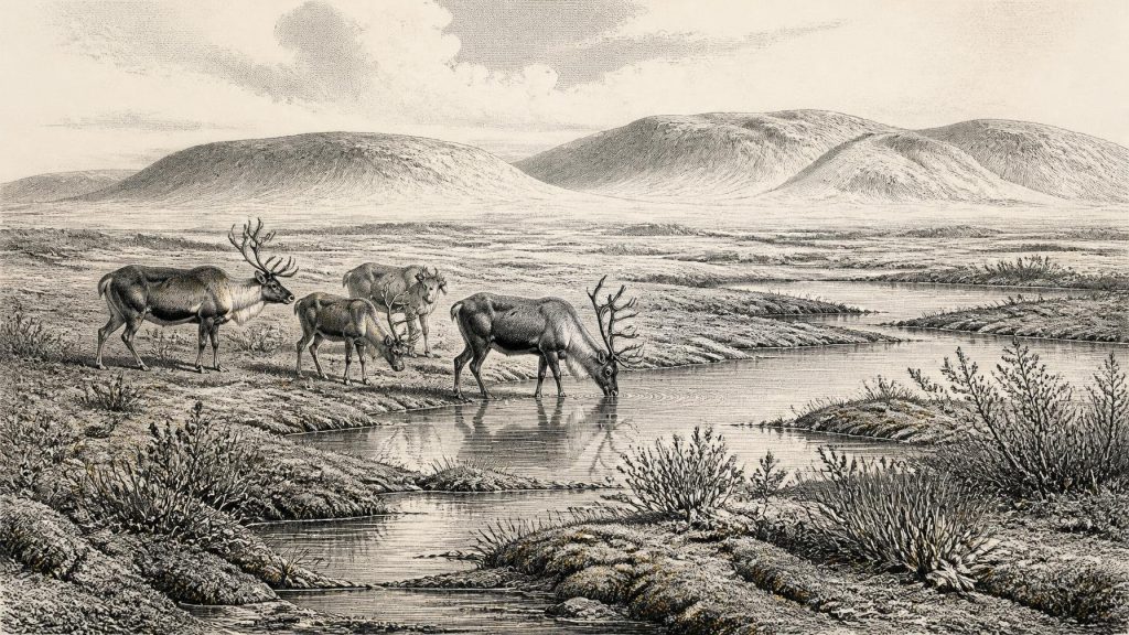
Its fossils describe a cold, treeless and waterlogged setting. Grasses and sedges, juniper, hardy herbs and a distinctive moss flora point to open vegetation rather than closed woodland. Plant remains include mountain-avens, dwarf willow, lesser clubmoss, bogbean (Menyanthes trifoliata) and water-milfoil. Together they indicate saturated ground, shallow pools and freshwater margins within a frost-affected landscape. Insect evidence supports the interpretation of muskeg-like wetland: wet, peaty or mossy ground with open water and abundant decaying vegetation. The evidence is strongest for the Derryvree locality itself; it should not be expanded into a detailed map of every Irish valley or coast.
Cold Country, Not Permanent Ice
The Derryvree sequence corrects two misleading extremes. Ireland at this time was not the wooded, temperate island familiar from later prehistory, but neither was it necessarily a single, unchanging expanse of permanent ice. MIS 3 involved abrupt climatic oscillations across the North Atlantic world. In south-west Ireland, uranium-thorium dating of broken cave stalagmites at Crag Cave demonstrates that calcite was deposited episodically during warmer interstadials, when liquid water could circulate through the shallow cave system. That does not date a particular mild spell to this numbered year, but it confirms a climate capable of rapid shifts between more and less favourable conditions.
The approach of heavier glaciation remained the great regional development. Reconstructions of the last Irish and British-Irish ice sheets place their maximum expansion later, broadly around 27,000–23,000 calibrated years BP in Ireland and its surrounding shelf seas. Around the horizon represented by this article, ice-sheet growth, local glacier advances, periglacial frost and changes in drainage were already reshaping the island. Subsequent ice would erode older deposits in some places while preserving others beneath till. Much of what can be known today is therefore an accident of survival: Derryvree endured because it was buried, while many former land surfaces did not.
Caves and Travelling Animals
County Cork’s Castlepook Cave, also called Mammoth Cave, offers a different kind of archive. Cave excavations there produced bones of animals associated with late Pleistocene cold-stage environments, including reindeer, woolly mammoth, giant deer, brown bear, wolf, Arctic fox, lemmings and spotted hyaena. The National Museum of Ireland regards Castlepook as the country’s most important site for mammal remains from the last cold stage. Such animals reveal that Ireland was connected ecologically to the wider north-west European world, able at intervals to receive or sustain species now absent from the island.
Yet the cave assemblage must not become a single imagined scene. Many of its deposits were excavated long ago, are mixed or disturbed, and contain material accumulated over a long period. Modern ultrafiltration radiocarbon work has shown that several older dates from southern Irish caves were substantially too young, changing interpretations of when particular animals were present. The revised work suggests that some species, notably spotted hyaena and giant deer, may have disappeared locally before about 40,000 calibrated years BP. A mammoth bone, a hyaena skull and a reindeer bone therefore demonstrate the broader MIS-3 faunal world, but do not prove that all these creatures shared one Cork landscape in 30,938 BCE.
For everyday life, animals provide stronger evidence than people. Reindeer are especially suggestive of open country with extensive grazing, while lemmings, mountain hare and Arctic fox indicate severe cold-stage conditions. Predators and scavengers such as hyaenas, wolves and bears imply food webs far more varied than later Irish faunas. There is no evidence, however, for herding, cultivation, cereal growing, livestock, pottery, metalwork, built villages or regular commerce. Any economy then present was ecological: plants grew in short seasons, herbivores moved through available habitats, and carnivores followed prey and carrion.
The Human Question
A reindeer femur fragment from Castlepook has attracted particular attention because a surface mark has been interpreted as having been made by a sharp stone tool during carcass processing. County Cork heritage material has presented the bone as possible evidence for human activity around 33,000 years ago. If that interpretation is confirmed, it would be exceptionally important: it would show that one or more Upper Palaeolithic people reached Ireland much earlier than the formerly accepted post-glacial settlement record.
The correct conclusion remains deliberately limited. One marked bone is not a settlement, camp, hearth, burial, tool assemblage, hunting territory or continuous population. It cannot tell us whether people killed the reindeer, found it dead, removed meat or hide, remained nearby, or returned. Crucially, the National Museum of Ireland continues to state that no clear evidence has yet emerged for human presence in Ireland during the Palaeolithic. The apparent tension reflects the state of the evidence: a significant claim is being investigated against a record that is extremely fragmentary. Around 30,938 BCE, human visitation is a possibility requiring further secure excavation and publication, not an established annual fact.
No Polities, Only Landscapes
Political affairs, conflict and diplomacy leave no identifiable trace for Ireland at this date. There are no names, boundaries, leaders, monuments, shrines or objects from which a religion can responsibly be reconstructed. Culture and learning cannot be described in specifically Irish terms either. If people were present, they may have belonged to wider mobile foraging networks of north-west Europe, but that is an inference from regional archaeology, not direct evidence of an Irish society. Likewise, lowered sea levels may have altered coastlines and routes, but neither a land crossing nor seafaring connection can be assumed for one moment in MIS 3.
The important development was instead the unstable relationship between land, climate and living things. Derryvree preserves a wetland that existed between glacial episodes; Crag Cave records intervals when water again made stalagmites; Castlepook preserves traces of a changing cold-stage fauna. Together, these archives show an Ireland of tundra-like vegetation, freshwater pools, periglacial ground and episodic ecological opportunity. They also demonstrate the limits of historical storytelling at such depth. This was not a year of recorded Irish events. It was a point within a long Ice Age transformation, whose surviving evidence is powerful precisely because it is sparse, local and carefully resistant to invention.
Primary Sources
- A Middle Midlandian Freshwater Series at Derryvree, Maguiresbridge, County Fermanagh, Northern Ireland
- The Irish Quaternary Fauna Project
- A Reconsideration of the Radiocarbon Dating of the Marine Isotope Stage 3 Fauna from Southern Ireland
- Episodic Speleothem Deposition Tracks the Terrestrial Impact of Millennial-Scale Last Glacial Climate Variability in SW Ireland
- Episodic Speleothem Deposition Tracks the Terrestrial Impact of Millennial-Scale Last Glacial Climate Variability in SW Ireland
- Landscapes and Environments of the Last Glacial-Interglacial Transition: A Time of Amazingly Rapid Change in Ireland
- Dimensions and Chronology of the Last Ice Sheet in Western Ireland
- Trimlines, Blockfields and the Vertical Extent of the Last Ice Sheet in Southern Ireland
- Reconstructing the Last Irish Ice Sheet 2: A Geomorphologically-Driven Model of Ice Sheet Growth, Retreat and Dynamics
- The Evolution of the Terrestrial-Terminating Irish Sea Glacier During the Last Glaciation
- The Deglaciation of the Western Sector of the Irish Ice Sheet from the Inner Continental Shelf to its Terrestrial Margin
- Radiocarbon Constraints on the Age of the Maximum Advance of the British-Irish Ice Sheet in the Celtic Sea
- Ireland: Submerged Prehistoric Sites and Landscapes
- Cenozoic: Tertiary and Quaternary
- A Palaeo-Glaciological Reconstruction of the Last Irish Ice Sheet
- The IntCal20 Northern Hemisphere Radiocarbon Age Calibration Curve (0–55 cal kBP)
- IntCal Publications
- Radiocarbon Calibration
- OxCal
- Spotted Hyena Skull
- Prehistoric Details
- Heritage Artefacts of County Cork
- New Insights on the Fauna of Ireland’s Younger Dryas and Early Holocene from Alice & Gwendoline Cave
