
Derryvree’s Bogbean Horizon31783 BCE
About 31,783 BCE, Ireland lay within the unstable Late Pleistocene MIS 3, not a recoverable historical year. Derryvree, County Fermanagh, preserves silts between glacial tills, dated broadly to 36,900–31,700 calendar years BP. Its bogbean, mosses, sedges, pollen and insects indicate treeless, periglacial wetlands with pools. Parts of north-central Ireland remained ice-free before British–Irish Ice Sheet expansion. Southern caves document open-country fauna, including reindeer, mammoth, horse, deer, bears, wolves and hyaenas, though not necessarily contemporaneously. A cut-marked Castlepook reindeer bone tentatively suggests human carcass processing, but no occupation exists. Later glaciation erased much evidence, leaving environmental archives and faint human traces.
Dateline
The label 31,783 BCE gives a useful point of orientation, but it must not be mistaken for a year that can be recovered from Ireland’s archaeological record. No written calendar existed, no named community is known, and no Irish deposit can be assigned responsibly to that single year. In modern chronological terms it falls roughly 33,700 years before AD 1950, during the Late Pleistocene and Marine Isotope Stage 3 (MIS 3). The evidence instead consists of calibrated ranges, fossil assemblages, sediments and reconstructions of changing ice. Together they illuminate an Ice Age Ireland that was cold, open and environmentally unstable, but not a land with identifiable rulers, settlements or historical events.
A Date Within Ranges
Radiocarbon dating does not yield a simple modern calendar date. It measures the remaining radioactive carbon in organic material, and its results must be calibrated against independently dated records. The calibration curve becomes less precise farther back in time, so a single measurement commonly corresponds to a range of possible calendar ages. This matters especially here. The strongest environmental record relevant to this notional year comes from Derryvree, near Maguiresbridge in County Fermanagh, where organic silts between two tills produced a conventional radiocarbon age of 30,500 years BP, with a substantial uncertainty. Calibration places that material broadly around 36,900–31,700 calendar years BP. Thus 31,783 BCE lies within the range, but cannot be claimed as the precise moment when the Derryvree plants grew or its animals lived.
The period is often described in Irish stratigraphy as part of the Midlandian glacial stage. Older local terminology gives the Derryvree deposits a place in a Middle Midlandian cold phase; international scholarship more usually locates them within MIS 3. These labels are frameworks for comparing records, not proof that conditions were identical across the island. Ireland’s climate and ice cover altered repeatedly on millennial and shorter scales. The responsible question is therefore not “what happened in 31,783 BCE?”, but what the surviving evidence permits us to say about Ireland around the middle of the fourth millennium before the Last Glacial Maximum.
A Wetland Beneath Ice Debris
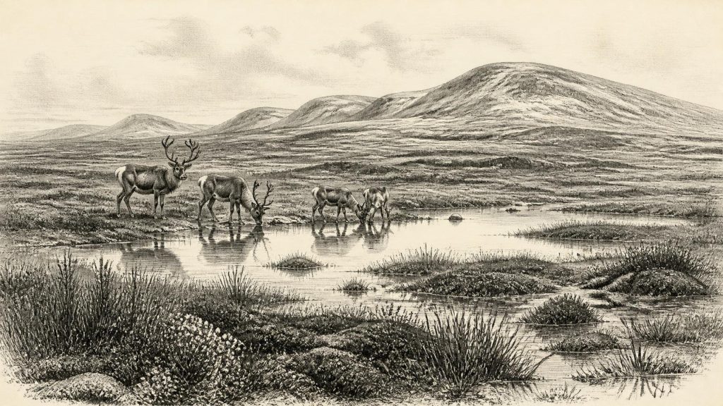
Derryvree is exceptional because road works in 1969 cut through a drumlin and exposed freshwater silts and fine sands sealed between two thick sheets of glacial till. The lower till records an earlier incursion of ice; the upper one shows that ice later returned and buried the wetland archive. Between them lay evidence of a landscape that was not under permanent glacier ice when the sediments accumulated. Plant remains, pollen and insects pointed to a treeless, periglacial setting: a cold terrain affected by frost, with pools and saturated ground rather than woodland or farmed fields.
The deposit contained mosses, sedges and other herbs, alongside a fossil seed of bogbean (Menyanthes trifoliata), a plant associated with shallow freshwater margins. Finds of mountain avens (Dryas octopetala) and juniper pollen reinforce the image of open ground. Insect evidence suggested a muskeg-like wetland with plant-rich pools, mossy margins and little shelter from wind. This was not a uniform white desert. Even in a rigorous climate, freshwater hollows could sustain aquatic and marsh vegetation during the short growing season. Yet neither should it be imagined as a benign modern bog. Frozen ground, seasonal snow, severe winters and sparse tree cover shaped a landscape in which living things occupied protected patches rather than a densely vegetated countryside.
Before the Greatest Ice Advance
At about 33,700 calendar years BP, Ireland had not yet reached the fullest extent of the last British–Irish Ice Sheet. Evidence synthesised from landforms, marine cores and numerical reconstruction indicates that important parts of north-central Ireland remained ice-free until at least about 34,000 years ago. The Derryvree and nearby Greenagho records are central to that conclusion. They demonstrate that deposits containing organic matter could accumulate before later ice overrode them. This does not establish that all of Ireland was free of ice, nor that the island’s shoreline resembled the present one; it establishes regional complexity.
Subsequent expansion was profound. Large-scale reconstructions chart sustained growth of the British–Irish Ice Sheet from roughly 31,000 to 26,000 years BP, with different sectors reaching their maxima at different times. Its overall maximum volume came later, around 23,000 years BP. For the world of 31,783 BCE, the chief historical development was therefore approaching glaciation rather than its climax: highlands could already support glaciers or ice caps, while lower ice-free ground persisted elsewhere. In the centuries and millennia ahead, advancing ice would scour, deform and conceal much of the earlier landscape, helping explain why the archaeological record is so fragmentary.
Animals of Open Country
Cave deposits, particularly in southern Ireland, show that a surprisingly varied large-mammal fauna entered the island during MIS 3. Castlepook Cave near Doneraile, County Cork, has produced remains attributed to reindeer, woolly mammoth, giant deer, brown bear, wolf, Arctic fox, hare and spotted hyaena. Shandon Cave in County Waterford has also yielded mammoth, reindeer, horse, red deer, bear and wolf. The dates of individual bones and the integrity of old collections require caution: many were excavated long before modern stratigraphic practice, and improved pretreatment has shown that some early radiocarbon determinations were too young. Nevertheless, redating confirms that important elements of the southern Irish fauna belong to MIS 3.
These animals should not be turned into a single simultaneous tableau. A bone proves that its species was present at some point within a dated interval, not that every listed animal grazed beside every pool in the year 31,783 BCE. The defensible interpretation is that parts of Ireland could support cold-adapted and open-country mammals over the wider period. Reindeer are particularly relevant to a tundra and grass-herb mosaic; mammoth and horse indicate broader continental connections in the faunal record; predators such as wolf and spotted hyaena point to food webs with substantial prey. Giant deer, often called the “Irish elk”, was neither uniquely Irish nor an elk, but a widespread extinct Eurasian deer whose fossils became especially famous in Ireland.
The Castlepook Question
Human history at this date rests on one intriguing but unresolved object: a reindeer femur from Castlepook Cave. Zooarchaeologist Ruth Carden identified a deep incision interpreted as a mark made by a sharp stone tool while a fresh carcass was being processed. Public heritage material has associated the bone with an age of about 33,000 years ago, broadly close to this article’s horizon. If that interpretation is confirmed, it would be remarkable evidence that an Upper Palaeolithic person handled a reindeer in Ireland many millennia before the best-established late-glacial traces of people on the island.
Its implications must remain limited. The bone derives from a historic cave collection, not from a modern excavation of an intact hearth or living floor. The date relates to the death of the animal, not independently to the creation of the mark, the location of its killing, or the length of a human visit. Carnivore activity, sediment movement, old excavation practices and later handling can complicate cave assemblages. Renewed work at Castlepook in 2022 located surviving sediments, but did not reveal a published Palaeolithic occupation surface: sampled charcoal and hazelnut shell in one area proved modern. There are no securely associated stone tools, built shelters, burials, human remains, ornaments or art from Ireland around 31,783 BCE.
No Polity, No Proven Settlement
Accordingly, political affairs, diplomacy and organised conflict cannot be narrated for Ireland at this point. There is no evidence for chiefs, tribes, territories, treaties or warfare. Nor is there evidence for permanent settlement, farming, herding, pottery, metalworking, monuments, long-distance exchange systems or formal religious institutions. To invent them would replace archaeology with fiction. The appropriate description of economy is ecological rather than commercial: animals moved through a severe landscape; plants exploited wet ground during the growing season; predators, scavengers and herbivores formed interconnected food webs.
If the Castlepook incision is anthropogenic, it permits one modest social inference only. Small, mobile hunter-gatherer parties may have entered parts of the Irish landmass during a favourable MIS 3 interval and processed animal carcasses. Such people would have depended upon portable equipment, knowledge of seasonal terrain and close attention to game, weather and shelter. But their number, language, origins, travel route, kinship and duration of stay are unknown. A brief incursion is not the same thing as a resident population, and it provides no basis for claiming continuity with Ireland’s later Mesolithic inhabitants.
An Archive of Loss and Survival
The deepest significance of this period lies in how it frames the archaeological survival of Ireland. Later ice expansion destroyed or redistributed much evidence that open-air activity might once have left behind. Caves and buried wetland sediments are therefore disproportionately important: they are rare places where bones, pollen, insects and organic layers escaped total erasure. Derryvree’s bogbean seed and Castlepook’s reindeer bone are small survivals from a vast vanished world.
For Ireland around 31,783 BCE, the evidence supports an open, cold, periglacial environment in at least some regions; ice-free ground in north-central Ireland during the broader dated interval; and a MIS 3 fauna capable of including reindeer and other large mammals in the south. It supports a possible, not yet definitive, episode of human carcass processing at Castlepook. It does not support an annual event, a settled society or a conventional political history. That restraint is not a deficiency. It is the real historical lesson of this remote Irish horizon: landscapes, animals and deposits speak clearly enough to show a country on the threshold of major glaciation, while preserving only the faintest suggestion of human footsteps.
Primary Sources
- Middle Midlandian Freshwater Series at Derryvree, Maguiresbridge, County Fermanagh, Northern Ireland
- A Reconsideration of the Radiocarbon Dating of the Marine Isotope Stage 3 Fauna from Southern Ireland
- The Irish Quaternary Fauna Project
- Growth and Retreat of the Last British–Irish Ice Sheet, 31,000 to 15,000 Years Ago: the BRITICE-CHRONO Reconstruction
- Trimlines, Blockfields and the Vertical Extent of the Last Ice Sheet in Southern Ireland
- Last Glacial Maximum Cirque Glaciation in Ireland and Implications for Reconstructions of the Irish Ice Sheet
- First Evidence of a Late Upper Palaeolithic Human Presence in Ireland
- Phylogeographic, Ancient DNA, Fossil and Morphometric Analyses Reveal Ancient and Modern Introductions of a Large Mammal: the Complex Case of Red Deer (Cervus elaphus) in Ireland
- New Insights on the Fauna of Ireland’s Younger Dryas and Early Holocene from Alice & Gwendoline Cave
- A Stratigraphic Framework for Abrupt Climatic Changes During the Last Glacial Period Based on Three Synchronized Greenland Ice-Core Records
- Consistently Dated Records from the Greenland GRIP, GISP2 and NGRIP Ice Cores for the Past 104 ka Reveal Regional Millennial-Scale δ18O Gradients
- Irish Cave Exploration
- 2022:564 – Castlepook Cave, Castlepook South, Cork
- Archaeology Research Excavation Grant 2022: Castlepook Cave Project Final Report
- Heritage Artefacts of County Cork 2021
- The Archaeological Heritage of County Cork
- Palaeoecology: Field Guide 16
- Late Midlandian, Pleistocene, Northern Ireland
- Ireland Under the Ice
- Growth and Retreat of the Last British–Irish Ice Sheet, 31,000 to 15,000 Years Ago
- Dimensions and Chronology of the Last Ice Sheet in Western Ireland
- Early Deglaciation of the British-Irish Ice Sheet on the Atlantic Shelf Northwest of Ireland Driven by Glacioisostatic Depression and High Relative Sea Level
