
Crag Cave’s Interstadial Water31562 BCE
Around 31,562 BCE, Ireland was part of a climatically unstable Late Pleistocene landscape, not a documented historical year. Derryvree sediments in Fermanagh indicate cold, open tundra and freshwater wetlands during an ice-free or less-glaciated interval. Crag Cave speleothems in Kerry record episodic liquid water, showing warmer interstadials amid severe conditions. Southern cave faunas included reindeer, horse, mammoth, giant deer and hyaena, demonstrating habitats for herbivores and predators. A marked Castlepook reindeer bone may indicate human butchery, but lacks secure archaeological context and cannot prove settlement. Subsequent ice-sheet growth reshaped and buried landscapes, leaving a fragmentary record requiring cautious interpretation today.
Dateline
“31,562 BCE” is a modern chronological label, not a recoverable Irish calendar year. No written record, seasonal sequence or dated human event allows historians to say what happened in Ireland in that particular year. In archaeological terms, the point lies roughly 33,500 calendar years before AD 1950, in the Late Pleistocene and Marine Isotope Stage 3 (MIS 3). Dates of this antiquity are expressed as ranges, not anniversaries: calibration converts radiocarbon measurements into calendar-age probabilities, and those ranges can change as methods improve. The responsible subject, therefore, is not an imagined episode but the evidence for Ireland during a broad, climatically unstable interval.
A Cold World Before Maximum Ice
This was an Ice Age world, but not simply an island sealed beneath one unchanging blanket of ice. The greatest expansion of the last British–Irish Ice Sheet came later, principally during the Last Glacial Maximum, when ice covered Ireland and extended across parts of the surrounding continental shelf. Around the date represented by 31,562 BCE, conditions were already severe and ice margins were dynamic, yet evidence shows that some Irish districts had earlier or intermittent ice-free landscapes. The exact extent of ice at any one moment remains uncertain, because glaciers advanced, stagnated and retreated on differing regional schedules, while much relevant terrain now lies offshore or beneath younger deposits.
The word “Ireland” must itself be used carefully. It denotes the landmass now called Ireland, not a state, nation or culturally unified territory. Sea level was substantially lower than today because water was stored in global ice sheets, changing the outline of coasts and exposing portions of the continental shelf. That did not necessarily make travel easy. Routes towards Britain and continental Europe were shaped by sea, rivers, marshes, local ice and shifting shorelines. It is reasonable to say that the geography of north-west Europe differed profoundly from the modern island setting; it is not responsible to draw a single assured land bridge or migration route for this precise horizon.
Derryvree’s Freshwater Evidence
The clearest directly relevant environmental archive comes from Derryvree near Maguiresbridge in County Fermanagh. Road works in 1969 exposed freshwater silts and fine sands sealed between two thick tills within a drumlin. The organic deposit produced the radiocarbon determination Birm-166, 30,500 radiocarbon years BP, with a substantial laboratory uncertainty. Later calibration has placed the deposit broadly at about 36,900–31,700 cal BP. That range encompasses the chronological neighbourhood of 31,562 BCE, but it is a span of millennia rather than proof of conditions on one day or in one year.
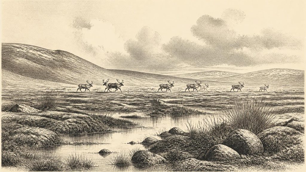
The Derryvree sediments are important because they preserve a landscape rather than merely a number. Plant macrofossils, pollen and insect remains indicated open tundra vegetation and a periglacial climate. Mosses, sedges, grasses, herbs and cold-adapted plants existed around freshwater and waterlogged ground. Finds including bogbean and mountain avens demonstrate that living vegetation occupied the locality; the deposit was not laid down under an all-enveloping glacier. Sparse and poorly preserved pollen cannot reconstruct every hillside or valley, however. It supports an interpretation of a largely treeless, cold, exposed wetland mosaic near Derryvree, not an exact map of all Ireland.
Water, Stone and Climate Pulses
Another valuable record lies far to the south-west at Crag Cave, County Kerry. Uranium-thorium dates from calcite formations show that speleothems grew episodically during MIS 3. Because calcite deposition in this shallow cave required circulating liquid water, it points to intervals when average annual temperatures locally rose above freezing. These pulses correspond broadly with abrupt warmer Greenland interstadials recorded in ice cores. They show that the Irish climate could change sharply across centuries and millennia, rather than descending evenly into the later glacial maximum.
Crag Cave does not tell us that every part of Ireland was mild, habitable or ice-free at the same time. It does, though, reinforce the central lesson of Derryvree: later Pleistocene Ireland experienced pronounced climatic oscillations. Brief ameliorations could allow unfrozen water, soil activity and plant growth, while colder phases restricted them. Such instability matters for every other question—where animals could graze, whether caves were accessible, how rivers behaved and whether people could make short visits.
Animals in the Open Country
The animal record, especially from limestone caves in the south, reveals a fauna unfamiliar in historic Ireland. Castlepook Cave near Doneraile, County Cork, has produced remains of reindeer, horse, brown bear, hare, fox, woolly mammoth, giant deer and spotted hyaena. Improved radiocarbon work has shown that several southern Irish cave specimens previously thought younger belong in MIS 3, before the Last Glacial Maximum. This does not mean all the species lived together at one moment or frequented the same patch of land. Cave deposits commonly combine material carried in by carnivores, water and sediment movement over long periods.
Nevertheless, the assemblages establish that parts of Ireland could support open-country herbivores and predators during the wider period. Reindeer are especially evocative because they imply seasonal grazing across sparse terrain, while hyaena bones and tooth-marked material show that caves could function as carnivore dens and bone accumulators. A cave therefore cannot automatically be read as a human home. It may have been a refuge, trap, den, drainage passage and archive in different episodes. The everyday economy visible with confidence is ecological: plants fed herbivores, predators exploited prey and carcasses, and caves preserved a biased fraction of that activity.
The Castlepook Human Question
A reindeer femur from Castlepook has made this period unusually significant for Irish archaeology. The bone has been publicly reported as about 33,000 years old and bears a deep linear mark interpreted by zooarchaeologist Ruth Carden as damage made by a sharp stone implement during carcass processing. County Cork heritage material consequently presents the find as potential evidence that Upper Palaeolithic hunters handled reindeer in the Doneraile area around 31,000 BCE. If that interpretation is confirmed, it would push evidence for human activity in Ireland far earlier than the long-established post-glacial record.
The qualification is essential. The specimen derives from an older cave collection rather than a modern excavation of an intact occupation surface. Its radiocarbon result dates the animal’s death, not automatically the making of the mark, the place where the animal died or the duration of a human visit. No stone tool has been recovered in secure association with it, and Ireland has no securely dated hearth, dwelling, burial, tool assemblage or repeatedly occupied campsite of comparable age. Carnivore damage, trampling, sediment movement, excavation damage and breakage must always be excluded when marks on bone are assessed. The femur is therefore a major and promising clue, not proof of permanent settlement, population continuity or an identifiable Irish Palaeolithic people.
People Beyond the Evidence
Upper Palaeolithic communities elsewhere in north-west Europe were mobile hunter-gatherers with sophisticated stone and organic technologies, social networks and knowledge of seasonal animal movements. Such comparative evidence makes a short human presence in Ireland plausible. It cannot supply facts that the Irish record has not yet yielded. We do not know the language, identity, kinship, beliefs, clothing, camp layout or political organisation of any people who may have reached Castlepook’s landscape. Nor is there evidence for diplomacy, leaders, territorial government or organised warfare in Ireland at this time.
If hunters did visit, they may have travelled in small groups, carried portable equipment and processed valuable meat, hide, sinew and bone away from or near a kill. That is an informed possibility based on wider Upper Palaeolithic practice, not a demonstrated reconstruction of Castlepook. No evidence supports agriculture, animal domestication, pottery, metalworking, monuments, formal trade institutions or lasting villages. Exchange, if it occurred, would have taken the form of movement and personal contact within wider hunter-gatherer landscapes rather than commerce between Irish communities.
Approaching a Transformed Landscape
The importance of this interval lies partly in what followed. Over subsequent millennia the expanding British–Irish Ice Sheet transformed drainage systems, shorelines and habitats, scouring landscapes, depositing tills and burying or removing evidence of earlier life. The drumlin at Derryvree literally records this sequence: an organic freshwater episode was enclosed between glacial deposits. Much evidence of any human activity may consequently have been destroyed, displaced, sealed beneath later sediments or submerged offshore. Absence of finds is not proof that nobody ever came; equally, it cannot be replaced by certainty.
For Ireland around 31,562 BCE, the best-supported history is one of cold but variable environments: open tundra and freshwater wet ground in Fermanagh, intermittent above-freezing conditions recorded by Kerry cave calcite, and large mammals moving through suitable southern habitats. The possibility of people rests on one remarkable marked reindeer bone, still awaiting the contextual evidence that would turn possibility into secure settlement history. In this deep past, caution is not a lack of story. It is the means by which a fragile story remains true to its surviving traces.
Primary Sources
- A Middle Midlandian Freshwater Series at Derryvree, Maguiresbridge, County Fermanagh, Northern Ireland
- Episodic Speleothem Deposition Tracks the Terrestrial Impact of Millennial-Scale Last Glacial Climate Variability in SW Ireland
- A Reconsideration of the Radiocarbon Dating of the Marine Isotope Stage 3 Fauna from Southern Ireland
- Exploring Controls of the Early and Stepped Deglaciation on the Western Margin of the British Irish Ice Sheet
- Trimlines, Blockfields and the Vertical Extent of the Last Ice Sheet in Southern Ireland
- Late Pleistocene Chronostratigraphy and Ice Sheet Limits, Southern Ireland
- Timing and Pace of Ice-Sheet Withdrawal Across the Marine–Terrestrial Transition West of Ireland During the Last Glaciation
- Maximum Extent and Dynamic Behaviour of the Last British–Irish Ice Sheet West of Ireland
- Ice Sheet Extension to the Celtic Sea Shelf Edge at the Last Glacial Maximum
- Maximum Extent and Readvance Dynamics of the Irish Sea Ice Stream and Irish Sea Glacier Since the Last Glacial Maximum
- Timing, Pace and Controls on Ice Sheet Retreat: an Introduction to the BRITICE-CHRONO Transect Reconstructions of the British–Irish Ice Sheet
- The Timing and Magnitude of the British–Irish Ice Sheet Between Marine Isotope Stages 5d and 2
- The IntCal20 Northern Hemisphere Radiocarbon Age Calibration Curve (0–55 cal kBP)
- Ireland: Submerged Prehistoric Sites and Landscapes
- The Colonization of Ireland: A Human Ecology Perspective
- Prehistoric Details: Mell Flint Flake
- Heritage Artefacts of County Cork
- 2022:564 – Castlepook Cave, Castlepook South, Cork
- Quaternary Geology of Ireland
- Geology of Ireland
- Palaeoecology: Irish Quaternary Association Field Guide
- New Insights on the Fauna of Ireland’s Younger Dryas and Early Holocene from Alice & Gwendoline Cave
