

Derryvree’s Bogbean Seed31306 BCE
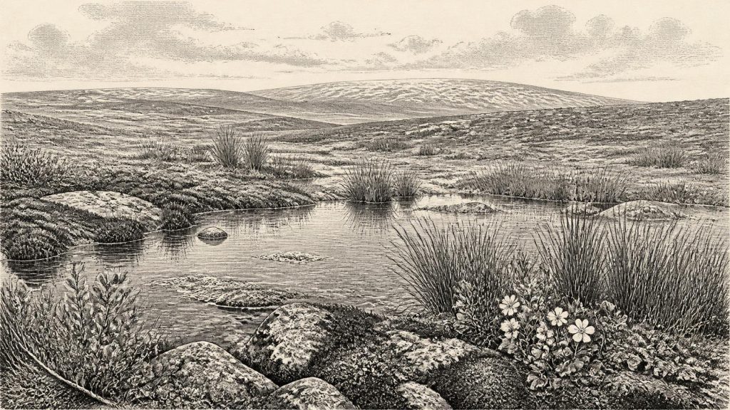
About 31,306 BCE, Ireland lay within the climatically unstable Late Pleistocene, although no precise event can be dated to that year. At Derryvree, County Fermanagh, freshwater silts between glacial tills, radiocarbon-dated broadly to 34,950–29,750 BCE, preserve a temporary periglacial wetland. Bogbean, mosses, sedges, grasses, juniper, insects and other fossils indicate open, treeless tundra-like ground with pools and seasonal thaw. Castlepook Cave, County Cork, records cold-stage mammals, including mammoth, giant deer, reindeer and hyaena, across a long timespan. No secure human settlement is known; a possible cut-marked bone remains uncertain. Advancing ice later overwhelmed such local ecosystems, preceding the glacial maximum.
Dateline
Modern calendar-year precision is not available for Ireland in 31,306 BCE. The label is a backward projection of the modern Gregorian calendar, not a date recorded by people living on the island. In archaeological usage it lies about 33,255 years before AD 1950, within the Late Pleistocene and Marine Isotope Stage 3 (MIS 3), a climatically volatile portion of the last Ice Age. Evidence from this depth of time is measured in broad ranges, not individual years. It comes principally from buried sediments, fossil plants and insects, animal bones, cave deposits and reconstructions of former ice sheets. These can illuminate conditions around the date, but cannot identify an event, ruler, battle or settlement in that particular twelve-month period.
A Landscape Between Ice Advances
The most valuable Irish evidence for this horizon was exposed at Derryvree townland, near Maguiresbridge in County Fermanagh. Roadworks in 1969 cut through a drumlin and revealed a sequence of freshwater silts and fine sands enclosed between two distinct layers of till, the unsorted sediment deposited by glacier ice. The order of the deposits is decisive. An earlier glacial phase formed the lower till; an interval then allowed water, sediment and organic matter to collect at the site; a later ice advance buried the freshwater deposit beneath upper till. Derryvree therefore preserves an interruption in local glaciation, not a tranquil landscape existing unchanged for centuries.
Organic material from the freshwater series produced a conventional radiocarbon age of 30,500 +1,170/−1,030 radiocarbon years BP. Radiocarbon years cannot simply be converted one-for-one into calendar years because atmospheric carbon-14 has varied through time. Using modern calibration, the determination corresponds broadly to about 36,900–31,700 calibrated years BP, or roughly 34,950–29,750 BCE. The modern date of 31,306 BCE falls within that wide range, close to its younger end, but it cannot be placed within a particular layer, season or generation. The responsible conclusion is that Derryvree offers a rare window on the Irish environment in the broad period surrounding this date.
That window also has geographical limits. Derryvree demonstrates that this part of Fermanagh supported a freshwater, periglacial environment during the formation of the deposit. It does not prove that the whole island was ice-free, equally cold, or covered by the same vegetation at one moment. Ireland was not yet a political or cultural unit; it was a varied north-west European landmass whose coastlines, ice margins and accessible routes changed as climate, sea level and ice loading changed. Local evidence must not be inflated into an island-wide map with sharp boundaries.
Mosses, Pools and Open Ground
The Derryvree fossils give this otherwise austere landscape texture. Pollen was poorly preserved, but plant macrofossils, mosses and insect remains point towards open tundra or muskeg: wet, peaty ground with shallow pools and plant-rich margins, set among exposed and sparsely vegetated surfaces. The deposits contain evidence of grasses, sedges, herbs and juniper, rather than closed woodland. Finds attributed to cold-adapted plants include mountain avens (Dryas octopetala), dwarf willow (Salix herbacea), lesser clubmoss (Selaginella selaginoides) and bogbean (Menyanthes trifoliata). A bogbean seed is particularly eloquent, because the plant requires wet ground: it attests to freshwater habitat amid a harsh climate.
These species should not be used to paint Derryvree as a modern Arctic garden transplanted intact into the past. Fossils record the organisms that entered and survived in particular sediments, while pollen can travel long distances or be redeposited. Still, the combined plant and insect evidence is stronger than any single specimen. It supports an interpretation of open, treeless land shaped by prolonged cold, frost action and seasonal thaw. Water could pool above frozen or seasonally frozen ground; mosses and sedges could flourish where drainage and shelter allowed; drier patches may have carried a thin cover of herbs and low shrubs. Summers were likely short, but sufficiently productive for wetland plants and invertebrates to complete their cycles.
This was not the familiar green and wooded Ireland of later millennia. Forest, farming fields, hedges and pasture all belong far in the future. Yet neither was it necessarily a blank expanse of permanent ice. Derryvree is important precisely because it preserves a functioning ecosystem during a non-glacial interval at the site. Its freshwater silts register running or standing water, its organic matter records biological productivity, and its enclosing tills show how vulnerable such environments were to renewed ice expansion.
Animals at the Western Edge
Animal remains from Irish caves provide a second, less precisely localised body of evidence. Castlepook Cave, near Doneraile in north Cork, is the island’s richest known site for vertebrate fauna in the period leading towards the Last Glacial Maximum. More than 2,000 bones recovered there represent a long and complicated accumulation, not one contemporary herd or one episode of occupation. Individual radiocarbon dates extend broadly from about 45,700 to 19,950 BP, and the cave was affected by carnivores, water movement and early twentieth-century excavation. Its fossils must therefore be read as a time-depth archive rather than a scene from 31,306 BCE.
Even with that caution, Castlepook establishes that Ireland supported, at intervals during MIS 3, an impressive cold-stage mammal community. The recorded fauna includes woolly mammoth, giant deer, reindeer, brown bear and spotted hyaena, with later Ice Age evidence for wolves, Arctic foxes and lemmings. Such animals did not all necessarily share the cave or the surrounding country at the same time. A hyaena den, for example, can concentrate bones carried in from elsewhere, while water and disturbed sediment can mix material of different ages. The evidence demonstrates that large herbivores and predators reached Ireland during the wider period; it does not provide a census of a single landscape.
Nevertheless, the ecological implications matter. Open vegetation could support grazing and browsing animals, while predators and scavengers followed concentrations of prey. Reindeer are particularly relevant to discussions of mobility because seasonal movement is characteristic of the species in many environments, but Irish fossil evidence cannot reconstruct a precise migration route, herd size or season. Lower global sea levels altered the surrounding shelf, yet ice, rivers, lakes and changing coastlines made access uneven. The presence of animals proves dispersal occurred during parts of the period; it does not show a continuous land bridge or an easily traversed corridor at this exact date.
People: A Possibility, Not a Population
There is no securely demonstrated settlement in Ireland around 31,306 BCE. No living floor, hearth, dwelling, cemetery, stone-tool assemblage, repeated activity surface or human remains can presently be assigned to this horizon. Consequently, there can be no evidence-based account of government, diplomacy, social rank, language, religious practice, art or formal learning. There were no known states, borders or named peoples on the island, and it would be anachronistic to call any possible visitors “Irish” in an ethnic or national sense.
A reindeer femur from Castlepook has been reported as carrying a mark interpreted as a possible stone-tool cut and as dating to roughly 33,000 years ago. If that interpretation is confirmed, it would indicate a brief human encounter with a carcass during MIS 3, greatly earlier than Ireland’s previously accepted terminal-Pleistocene evidence for human activity. But two questions must remain separate: the age of the bone and the cause of the mark. Carnivore damage, sediment abrasion, breakage and excavation disturbance must be excluded before a surface incision can bear the weight of a major claim. Even a confirmed cut mark would document butchery by a person or small group, not permanent occupation.
It is reasonable to say that Upper Palaeolithic hunter-gatherers elsewhere in north-west Europe possessed the knowledge to exploit large animals for meat, hide, sinew, antler and bone. It is not reasonable to transfer their camps, technologies or beliefs wholesale to Ireland without associated finds. The economy visible here is first an ecological one: plants converting a brief growing season into biomass; herbivores using open country and wetland margins; carnivores exploiting prey; and perhaps, only perhaps, transient people taking opportunities within that web. Trade, agriculture, herding, monuments and long-lived villages are unsupported for Ireland at this date.
The Approach of Maximum Cold
In the longer regional story, the key development was environmental instability and the growing power of ice. Modern BRITICE-CHRONO research reconstructs the British–Irish Ice Sheet at thousand-year intervals from 31,000 to 15,000 years BP and shows that its growth and retreat were asynchronous around Ireland and Britain. The full island-wide maximum lay later, with extensive ice coverage during MIS 2 and maximum ice-sheet area around 26,000 BP in the wider British–Irish system. Around the date considered here, however, the future maximum was approaching rather than already represented by a single uniform condition across Ireland.
Derryvree’s freshwater deposit and its later burial capture that fundamental fact more vividly than any imagined event could. Around 31,306 BCE, Ireland’s history is not a chronicle of chiefs or kingdoms but a record of changing ice, water, plants and animals. The bogbean seed beneath a Fermanagh drumlin is evidence of a cold wetland existing within a broad calibrated interval. The cave bones of Cork show that formidable mammals had reached the island at various times. Together, these archives reveal a living but precarious Ice Age country, while also setting firm limits on what can honestly be claimed about its human past.
Primary Sources
- A Middle Midlandian Freshwater Series at Derryvree, Maguiresbridge, County Fermanagh, Northern Ireland
- A Middle Midlandian Freshwater Series at Derryvree, Maguiresbridge, County Fermanagh, Northern Ireland
- Palaeoecology
- Early Midlandian–Middle Midlandian, Pleistocene, Northern Ireland
- Trimlines, Blockfields and the Vertical Extent of the Last Ice Sheet in Southern Ireland
- Growth and Retreat of the Last British–Irish Ice Sheet, 31,000 to 15,000 Years Ago: The BRITICE-CHRONO Reconstruction
- BRITICE-CHRONO Maps and GIS Data of the Last British-Irish Ice Sheet 31 to 15 ka
- Timing, Pace and Controls on Ice Sheet Retreat: An Introduction to the BRITICE-CHRONO Transect Reconstructions of the British–Irish Ice Sheet
- Pattern and Timing of Retreat of the Last British-Irish Ice Sheet
- Cork County Geological Site Report: Castlepook Cave
- The Irish Quaternary Fauna Project
- A Reconsideration of the Radiocarbon Dating of the Marine Isotope Stage 3 Fauna from Southern Ireland
- New Insights on the Fauna of Ireland's Younger Dryas and Early Holocene from Alice & Gwendoline Cave
- First Evidence of a Late Upper Palaeolithic Human Presence in Ireland
- 2022:564 – Castlepook Cave, Castlepook South, Cork
- The IntCal20 Northern Hemisphere Radiocarbon Age Calibration Curve (0–55 cal kBP)
- IntCal Publications
- The Geology of Ireland
- Quaternary Geomorphology Map of Ireland
- Mammals
- Mammoth and Musk Ox ESR-Dated to the Early Midlandian at Aghnadarragh, County Antrim, Northern Ireland, and the Age of the Fermanagh Stadial
- Freshwater Organic Deposits and Stratified Sediments Between Early and Late Midlandian Till Sheets, at Aghnadarragh, County Antrim, Northern Ireland
- Menyanthes trifoliata L.
- Dryas octopetala L.
- Salix herbacea L.