
The Doneraile Reindeer Passage31307 BCE
Around 33,300 calibrated years ago, Ireland lay within the climatically unstable MIS 3 Ice Age. Derryvree sediments in Fermanagh indicate treeless tundra-like wetlands and freshwater during an interval before renewed glaciation, while Crag Cave calcite records episodically milder conditions. Although severe, this period preceded island-wide coverage by the later British–Irish Ice Sheet. Castlepook Cave in County Cork preserved reindeer, mammoth, giant deer, carnivores and cold-adapted small mammals, revealing open tundra-steppe habitats. A reindeer femur bearing a possible stone-tool cut-mark may represent Ireland’s earliest human trace, but cannot prove permanent occupation. Evidence remains fragmentary, range-based and vulnerable to later glacial disturbance.
Dateline
“31,307 BCE” is a useful modern filing label, not a date at which Ireland can be observed in historical focus. No written record, named community, ruler, settlement plan or event can be assigned to this calendar year. Archaeology instead works with ranges: radiocarbon determinations, calibrated against changing atmospheric carbon levels; cave deposits; pollen, plant remains and insects; animal bones; and evidence of former ice. In conventional archaeological terms, the notional year lies about 33,256 years before AD 1950, or roughly 33.3 thousand calibrated years before present (cal BP). That places it within Marine Isotope Stage 3 (MIS 3), a long, climatically volatile part of the last Ice Age, rather than within a dateable “Irish year”.
A Date Within a Range
The most directly relevant environmental sequence is at Derryvree near Maguiresbridge, County Fermanagh. There, organic-rich freshwater silts were preserved between two layers of glacial till. A radiocarbon determination on the organic material, Birm-166, was formerly expressed as 30,500 radiocarbon years BP with substantial uncertainty; calibrated estimates place the deposit broadly between about 36,900 and 31,700 cal BP. The nominal year considered here falls inside that wide interval. It is therefore responsible to say that Derryvree illuminates conditions in northern Ireland around this point in deep time, but not to claim that it records the conditions of one particular year or decade. Calibration itself is essential: a radiocarbon age is not automatically a calendar age, especially this far back.
The Derryvree sediments are important precisely because Ireland’s surviving evidence is uneven. Later ice advances eroded, rearranged or buried many older land surfaces. Caves sometimes protected bones and calcite deposits; wet hollows could preserve plant-rich mud; but neither kind of archive is a complete landscape map. Their value lies in bringing together independent clues. Derryvree’s freshwater deposits demonstrate that, during part of later MIS 3, a basin in Fermanagh held open water and wet ground before a renewed ice advance sealed it beneath till. They do not prove that every part of Ireland was similarly ice-free, nor that conditions remained stable throughout the thousands of years represented by the range.
Wet Ground in a Cold Country
The plant and animal microfossils from Derryvree indicate a treeless, cold-climate environment. Mosses, sedges and low herbaceous plants, together with aquatic and wetland species such as bogbean and water-milfoil, point to shallow freshwater, marshy margins and tundra-like vegetation. Such a setting was not a forested Ireland, nor a featureless white wilderness. In favourable summer months, low plants could cover damp ground, insects could thrive, and pools could support aquatic life. Yet exposed terrain, frozen or seasonally frozen soil, strong winds and a short growing season would have limited taller vegetation. The term “tundra” is a useful ecological comparison, provided it is not mistaken for a precise reconstruction of every field, hill and shoreline.
Crag Cave in County Kerry offers a second, very different archive. Uranium-series dating shows that calcite formations grew episodically in the cave during MIS 3. Stalagmite growth requires liquid water to seep through soil and rock, so these pulses are evidence for intervals when ground conditions were sufficiently mild for water movement and biological soil activity. They correspond broadly with warmer Greenland Interstadials, the abrupt ameliorations visible in Greenland ice-core records. This does not turn Ireland into a warm country at 31,307 BCE. Rather, it confirms that the Atlantic edge of Europe experienced marked climatic oscillations: phases cold enough to inhibit dripstone growth alternated with relatively milder episodes in which permafrost retreated locally and caves received water again.
Before the Maximum Ice
This was before the Last Glacial Maximum, when the British–Irish Ice Sheet ultimately covered the whole island. The maximum of that later ice-sheet phase is generally placed from roughly 27,000 cal BP onwards, with its most extensive stages occurring later still. At about 33,300 cal BP, Ireland was already in a severe glacial world, but the evidence does not support a simple picture of unbroken island-wide ice cover. The inter-till freshwater bed at Derryvree, cave calcite in south-west Ireland and dated animal remains from southern caves instead show that habitable terrestrial and freshwater environments existed during parts of MIS 3. Their extent and duration remain debated because later glaciation destroyed so much evidence.
Sea level was much lower than today because vast quantities of water were held in northern ice sheets, and the geography of the Irish Sea basin was therefore unlike the modern map. It would nevertheless be unsafe to portray a known land bridge or a fixed migration route linking Ireland with Britain and continental Europe at this exact time. The relevant coastlines shifted with sea level, local ice margins and isostatic movements of the land. What can safely be said is that large mammals reached Ireland in this era, demonstrating that dispersal was possible at least intermittently. Whether particular movements occurred over exposed ground, narrow water barriers, seasonal ice, or combinations of these cannot be settled from the Irish evidence for this notional year.
Castlepook’s Faunal World
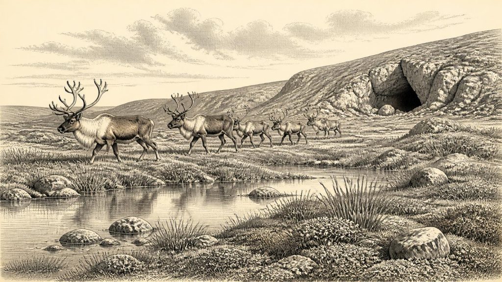
The strongest evidence for animals near this date comes from Castlepook Cave, also called Mammoth Cave, near Doneraile in north County Cork. Excavations there between 1904 and 1913 recovered an exceptionally rich but complicated bone assemblage. Reindeer were especially abundant, while woolly mammoth, giant deer, brown bear, wolf, Arctic fox, mountain hare, collared lemming, Norwegian lemming and spotted hyaena are among the animals identified from the cave collections. The combination evokes open, cold grassland and tundra-steppe rather than woodland. Reindeer would have found grazing in such landscapes; lemmings and Arctic foxes indicate particularly cold ecological conditions; and hyaenas and wolves were major scavengers and predators.
Yet Castlepook is not a single frozen tableau. Bones accumulated through different processes and across long spans of time. Hyaenas could drag carcass parts into their den; other animals could die nearby; water could redeposit material; and early excavators removed much of the original sediment before modern recording standards existed. Improved radiocarbon pretreatment has also shown that several old Irish cave dates were too young, altering the chronology substantially. Re-dating confirms a significant MIS 3 fauna in southern Ireland, but it also requires caution: a mammoth bone, a hyaena tooth and a reindeer limb need not have arrived in the cave in the same season, century or climatic pulse.
The Reindeer Femur
One Castlepook object gives this period its special historical tension: a fragment of reindeer femur, held by the National Museum of Ireland, Natural History. County Cork heritage interpretation dates it to about 31,000 BCE and identifies a deep mark on the bone as damage made by a sharp stone implement during butchery. If that diagnosis is upheld, the specimen is potentially Ireland’s earliest evidence for human activity, suggesting that Upper Palaeolithic people processed a reindeer carcass during a relatively favourable part of the Ice Age. The implied people would have been highly mobile hunter-gatherers, not farmers or permanent villagers: no crops, domestic stock, pottery, metalworking or built settlement belongs to the evidence at this date.
However, the distinction between possibility and demonstration matters. The femur is not from a newly excavated, sealed camp floor. No securely associated stone-tool assemblage, hearth, house, burial, repeated butchery area or other material evidence establishes a settlement at Castlepook in this period. The date concerns the animal bone, while the proposed cut-mark depends on close taphonomic interpretation of the bone surface. It is reasonable to describe the femur as a serious and potentially transformative indication of human handling; it is not reasonable to turn it into proof of a permanent Irish population, a named hunting band, or a continuous line of occupation. Modern excavation and microscopic re-examination are needed to test the claim further.
No Politics, But a Human Frontier
There is no evidence from which to reconstruct political affairs, diplomacy, organised warfare, religion, language, artistic traditions or formal learning in Ireland at 31,307 BCE. There were no states, kingdoms, tribes known by name or institutions identifiable in the record. If people did reach the island, their social world can only be approached by comparison with Upper Palaeolithic hunter-gatherers elsewhere in north-west Europe: small, mobile groups whose knowledge of animal movements, shelter, stone resources, weather and seasonal food would have been critical. Such comparison is interpretation, not direct Irish evidence.
The most important development around this notional date was environmental opportunity amid instability. Northern freshwater wetlands, southern limestone caves and open grazing country show that Ireland was not merely an empty prelude to later history. It was a changing north-western margin of Ice Age Europe, inhabited by large mammals and carnivores, periodically affected by abrupt climatic shifts, and perhaps visited by people. Derryvree supplies the broad environmental setting; Castlepook supplies the animals and one provocative possible human trace. Together they demand a history written in calibrated ranges, probabilities and carefully stated limits rather than invented calendar events.
Primary Sources
- A reconsideration of the radiocarbon dating of the Marine Isotope Stage 3 fauna from southern Ireland
- The Irish Quaternary Fauna Project
- A Middle Midlandian Freshwater Series at Derryvree, Maguiresbridge, County Fermanagh, Northern Ireland
- Episodic speleothem deposition tracks the terrestrial impact of millennial-scale last glacial climate variability in SW Ireland
- Growth and retreat of the last British–Irish Ice Sheet, 31,000 to 15,000 years ago: the BRITICE-CHRONO reconstruction
- Pattern and timing of retreat of the last British-Irish Ice Sheet
- Dimensions and chronology of the last ice sheet in Western Ireland
- Trimlines, blockfields and the vertical extent of the last ice sheet in southern Ireland
- Oscillating retreat of the last British-Irish Ice Sheet on the continental shelf offshore Galway Bay, western Ireland
- Maximum extent and dynamic behaviour of the last British–Irish Ice Sheet west of Ireland
- Response of the Irish Ice Sheet to abrupt climate change during the last deglaciation
- New insights on the fauna of Ireland's Younger Dryas and Early Holocene from Alice & Gwendoline Cave
- Heritage Artefacts of County Cork
- 32564: Castlepook Cave, Co. Cork
- On the Cave of Castlepook, Near Doneraile, Co. Cork
- The IntCal20 Northern Hemisphere Radiocarbon Age Calibration Curve (0–55 cal kBP)
- High-resolution record of Northern Hemisphere climate extending into the last interglacial period
- A 60,000 year Greenland stratigraphic ice core chronology
- A stratigraphic framework for abrupt climatic changes during the Last Glacial period based on three synchronised Greenland ice-core records
- The Last Glacial Maximum
- Geology of Ireland
- Ireland Through Geological Time
- IQUA Guide 16
