
Bogbean Under Fermanagh31151 BCE
Around 31,151 BCE, Ireland lay in climatically unstable Marine Isotope Stage 3, not a datable historical moment. At Derryvree, County Fermanagh, freshwater sediments between glacial tills, radiocarbon-dated broadly to 36,900–31,700 calibrated BP, record an ice-free local basin before later glaciation. Mosses and plant remains, including bogbean and mountain avens, indicate open tundra wetland with sparse vegetation and severe seasonal conditions. Wider fossil evidence documents reindeer, mammoth, giant deer, wolves and hyaenas, though not contemporaneous communities. No secure human settlement is known; possible cut marks on a reindeer bone remain unconfirmed. Subsequent ice expansion remodelled Ireland and obscured evidence of life.
Dateline
The label 31,151 BCE is useful only as a modern point on a very long timescale. It corresponds approximately to 33,100 years before present, conventionally counted from AD 1950, but no Irish evidence can identify an event, a person, or even a particular season in that calendar year. The appropriate setting is the later part of Marine Isotope Stage 3, a cold and climatically unstable phase of the Last Glacial Period. For Ireland, the evidence comes chiefly from buried sediments, fossil animal remains, cave deposits and broad radiocarbon ranges. It permits a responsible reconstruction of landscapes and possibilities; it does not provide a dated chronicle.
A Date Without a Diary
The most illuminating record close to this notional date lies at Derryvree, near Maguiresbridge in County Fermanagh. Roadworks in 1969 cut through a drumlin and exposed freshwater silts and fine sands between two thick layers of till, the unsorted material deposited by glacier ice. The sequence is important because its order is unambiguous: an earlier glacial episode laid down the lower till; a period without ice at that locality allowed a wetland or shallow freshwater body to accumulate sediment and organic remains; a later ice advance sealed the deposit beneath another till sheet.
Organic material from the Derryvree bed produced a conventional radiocarbon age of 30,500 years BP, with a substantial uncertainty of +1,170 and −1,030 years. Radiocarbon years are not calendar years. Their conversion depends on changing atmospheric carbon levels and carries widening uncertainty at this depth of time. Published discussion places the Derryvree deposit broadly at about 36,900–31,700 calibrated years BP, or roughly 34,950–29,750 BCE. Thus 31,151 BCE falls within the possible span of this archive, but it cannot be assigned to an individual layer, plant, insect or occurrence. Derryvree is a time-averaged environmental record, not a diary from one year.
Fresh Water Between Ice Advances
The Derryvree silts show that at least part of north-central Ireland was ice-free when they formed. They do not prove that the whole island was free of glacier ice at the same moment. The extent, thickness and timing of the developing Irish sector of the British–Irish Ice Sheet remain matters reconstructed from scattered terrestrial deposits, landforms, offshore sediments and numerical dating. What can be said with confidence is that the vast ice cover associated with the local Last Glacial Maximum came later. Recent syntheses use Derryvree as evidence for pre-Last Glacial Maximum ice-free conditions in this sector, before expansion towards the Donegal Bay region and the fuller glaciation of Ireland in Marine Isotope Stage 2.
This was therefore not Ireland beneath the familiar later ice sheet, nor an island of settled fields, woodland and shorelines recognisable today. It was a changing northern landscape close to the limits of severe cold. At Derryvree, water collected in a low basin amid terrain shaped by earlier glaciation. Frost, seasonal thaw, wind and moving water were likely as important as vegetation in forming the ground surface. Local conditions around a pool or marsh could differ sharply from those on exposed slopes, gravelly ridges or higher ground. The evidence is strongest for this locality, and care is needed before extending its picture across every Irish region.
An Open Tundra Wetland
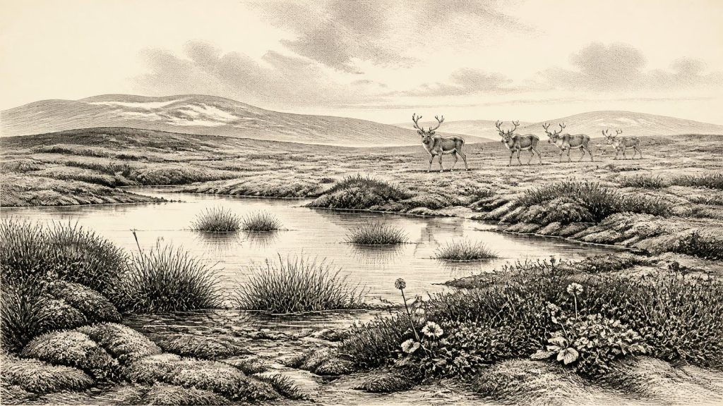
Plant and animal traces in the Derryvree freshwater series indicate open tundra and a periglacial climate: cold conditions in which the ground experienced intense freezing, though the site itself was not then under glacier ice. Pollen was poorly preserved, but largely herbaceous. Mosses and macrofossils provided much of the clearer evidence. Finds included plants associated with damp, cold environments, among them bogbean (Menyanthes trifoliata) and mountain avens (Dryas octopetala). Such remains point to wet margins, shallow freshwater and low vegetation rather than closed forest.
That conclusion should be stated precisely. A bogbean seed does not recreate a continuous modern-style fen, and mountain avens does not map the entire countryside. Yet together with the sedimentary setting, the assemblage demonstrates that plants able to occupy cold freshwater edges and open ground survived locally. The landscape probably comprised a mosaic: pools and muddy margins, moss-rich wet ground, sedge or grass communities, herbs, sparse scrub in favourable niches and more exposed stony or frost-disturbed surfaces. Short growing seasons and a severe winter climate limited tree cover. Derryvree gives Ireland one of its rare direct glimpses of an Ice Age flora before the final major glacial advance.
The climate was not static. Marine Isotope Stage 3 was marked across the North Atlantic region by abrupt shifts between relatively milder interstadial conditions and colder stadials. Irish deposits cannot always be matched neatly to one named Greenland event, especially given chronological uncertainty, but their character reflects a world prone to rapid environmental change. A shallow pool may have persisted for centuries or millennia while its catchment altered through frost action, sediment influx and changes in seasonal meltwater. The later burial of Derryvree beneath till is a material reminder that apparently viable cold-country habitats could be erased or transformed by renewed ice expansion.
Animals in a Connected Northwest Europe
Cave deposits and old collections from southern Ireland show that the island’s Late Pleistocene animal world was much richer than its later historic fauna. Research on the Irish Quaternary fauna has documented the presence, at different times between at least about 45,000 and 20,000 years ago, of mammals including reindeer, mammoth, giant deer, wolf and spotted hyaena. Castlepook Cave, near Doneraile in north County Cork, is especially important. Its deposits and collections contain remains from a cold-stage fauna, although cave accumulations are complicated records: bones may have been carried in by carnivores, water, gravity or later disturbance, and need not represent a single living community or date.
Reindeer are particularly relevant to an open, cool landscape, but their bones alone do not establish how numerous they were in Ireland, whether they made regular migrations, or which precise habitats they used in 31,151 BCE. Likewise, hyaena remains and gnawed bones at Castlepook demonstrate the presence of large carnivores in the broader Pleistocene faunal record, not a scene of hyaenas and reindeer meeting at every Irish wetland. Revised radiocarbon work has also shown why older cave chronologies require reassessment: several Castlepook dates became significantly older when bones were re-dated using improved methods. Interpretation must follow the dated specimen and its context, rather than repeating inherited assumptions about an undifferentiated ‘Ice Age fauna’.
The Human Question
There is no secure settlement, hearth, dwelling, burial, tool-making floor or community known from Ireland that can be placed specifically in 31,151 BCE. Consequently, no responsible account can describe an Irish tribe, chief, political territory, war, alliance, religious rite, language or system of learning for this date. There were no known states, institutions or diplomatic relations on the island in the historical sense. The absence of such evidence is not proof that no person ever crossed the region during the wider period; it is a limit on what archaeology presently demonstrates.
A reindeer femur from Castlepook has been publicly reported as bearing deep marks interpreted as cuts made by a stone tool and as dating to roughly 33,000 years ago. If that interpretation is sustained by full published contextual and taphonomic study, it would be exceptionally important evidence for very early human activity in Ireland: people may have processed an animal carcass in, or near, north Cork during the broader interval. At present, however, the claim should not be inflated into proof of a permanent population, a camp at the cave, a hunting party on a specified date, or an origin story for later Irish communities. A marked bone is not a settlement assemblage, and a date on animal collagen does not identify the exact moment of butchery.
The possibility is nevertheless historically significant. During lower sea-level phases, Ireland formed part of a north-west European world with very different coastlines and connections from those of today. Animal colonisation itself shows that routes existed across changing terrestrial and marine barriers at various times. Any human visitors would have belonged to wider Upper Palaeolithic populations of north-west Europe, reliant on mobility, detailed environmental knowledge, stone technology and the processing of animal resources. That is an inference from regional human prehistory, not direct evidence of a settled Irish society.
Economy, Culture and Silence
For this date, ‘economy’ can only mean ecology and subsistence possibilities, not markets or trade. The available fauna suggests that large herbivores and scavenging carnivores moved through parts of Ireland during the wider Middle Midlandian interval. If people were present, meat, fat, hide, sinew, bone and perhaps antler would have been valuable materials; but no Irish artefact assemblage of this age permits a reconstruction of their techniques, exchange networks or seasonal rounds. Nor is there evidence for farming, animal husbandry, ceramics, metalworking, monuments, formal burial, art or writing.
Culture is visible instead in the scientific culture of evidence: a seed in water-laid silt, a moss fragment, a reindeer bone, tooth marks, sediment between tills and the laboratory methods that date or re-date them. These small survivals correct the misleading impression that prehistoric Ireland was either permanently frozen or empty until the much later Mesolithic. Around the modern label 31,151 BCE, Ireland was a climatically harsh but locally habitable part of a fluctuating Pleistocene north-west Europe. Its best-attested story is environmental: tundra wetland at Derryvree, mobile fauna across changing landscapes, and an unresolved but potentially momentous question over the earliest human presence.
The decisive change still lay ahead. As ice expanded during the succeeding colder phase, it would cover or profoundly remodel much of the island, destroying many surface traces and helping explain why the archaeological record is so thin. For now, the responsible portrait is neither a blank nor a legend. It is a cold freshwater basin beneath the future drumlin of Fermanagh, preserving a narrow, calibrated window onto Ireland before the deepest freeze.
Primary Sources
- A Middle Midlandian Freshwater Series at Derryvree, Maguiresbridge, County Fermanagh, Northern Ireland
- A reconsideration of the radiocarbon dating of the Marine Isotope Stage 3 fauna from southern Ireland
- The Irish Quaternary Fauna Project
- Exploring controls of the early and stepped deglaciation on the western margin of the British Irish Ice Sheet
- Trimlines, blockfields and the vertical extent of the last ice sheet in southern Ireland
- Extent and deglacial chronology of the last British–Irish Ice Sheet: implications of exposure dating using cosmogenic isotopes
- Radiocarbon constraints on the age of the maximum advance of the British–Irish Ice Sheet in the Celtic Sea
- Late Pleistocene chronostratigraphy and ice sheet limits, southern Ireland
- Last Glacial Maximum cirque glaciation in Ireland and implications for reconstructions of the Irish Ice Sheet
- Dimensions and chronology of the last ice sheet in Western Ireland
- Vertical dimensions and age of the Wicklow Mountains ice dome, Eastern Ireland, and implications for the extent of the last Irish Ice Sheet
- New data for the Last Glacial Maximum in Great Britain and Ireland
- Palaeoecology
- The Subdivision of the Quaternary Period in Ireland
- Menyanthes trifoliata
- Dryas octopetala
- The IntCal20 Northern Hemisphere Radiocarbon Age Calibration Curve (0–55 cal kBP)
- A 250,000-year ice-core climate record from the North Greenland Eemian Ice Drilling (NEEM) project
- The Last Glacial Maximum
- The BRITICE CHRONO project: A new chronology for the British–Irish Ice Sheet
- New insights on the fauna of Ireland's Younger Dryas and Early Holocene from Alice & Gwendoline Cave
- Phylogeographic, ancient DNA, fossil and morphometric analyses reveal ancient and modern introductions of a large mammal: the complex case of red deer (Cervus elaphus) in Ireland
- Guide to the National Museum of Ireland: Archaeology
- A critical review and re-investigation of the Pleistocene deposits of Northern Ireland
