

Castlepook’s Single Cutmark31138 BCE
Labelled 31,138 BCE, this period cannot represent a recorded Irish year, but falls within a broad late-Pleistocene chronological range. Derryvree sediments in Fermanagh preserve evidence of cold, treeless wetland between glacial advances, while other deposits and Crag Cave calcite demonstrate changing regional conditions. Around 31,000 years ago, the British–Irish Ice Sheet was expanding, reshaping landscapes and obscuring archaeological traces. Castlepook Cave’s cold-stage fauna includes a reindeer femur with a possible stone-tool cutmark, suggesting, but not proving, brief human activity. No settlement, culture, routes, politics or society can be reconstructed. The period’s history is environmental, reconstructed from sediments, bones and dating.
Dateline
“31,138 BCE” is a useful modern label, but it cannot denote an Irish event recorded in a particular year. No calendar, written testimony, named community or securely dated settlement survives from this depth of time. In archaeological terms it corresponds roughly to 33,100 calibrated years before present (cal BP, where “present” is AD 1950), during the later part of the Pleistocene and within Marine Isotope Stage 3. At such antiquity, even well-dated deposits normally provide ranges of centuries or millennia. The responsible history of Ireland at this point is therefore not an annual chronicle, but an account of changing ice, water, plants, animals and the exceptionally thin possibility of human activity.
A Date Beyond Calendar History
Radiocarbon results are not calendar dates read directly from a specimen. They measure remaining carbon-14 and must be calibrated against independently dated records of past atmospheric change. Calibration at thirty thousand years and more is necessarily less precise than in later prehistory. A numbered BCE year can locate Ireland approximately within a global chronology, but cannot identify a season, a generation, a migration or an encounter. Nor can it justify attaching a cave bone or a layer of sediment to that single year.
The most informative Irish evidence comes from deposits that accumulated across long intervals. At Derryvree, near Maguiresbridge in County Fermanagh, roadworks exposed organic-rich freshwater silts and fine sands trapped between two tills: dense sediments laid down by glacier ice. The sequence is valuable because its order is clear. Ice deposited the lower till; afterwards, a local basin supported freshwater and wet ground in which mineral sediment, plants and insects accumulated; then a later ice advance laid down the upper till and sealed the older landscape. The organic layer produced a conventional radiocarbon age of 30,500 with a large uncertainty of +1,170/−1,030 years. Published calibration places it broadly around 36,900–31,700 cal BP. Thus the requested date lies within the wide chronological horizon illuminated by Derryvree, but not at a demonstrable point within its life.
Wet Ground Beneath a Cold Sky
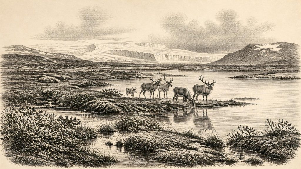
Derryvree indicates a cold, largely treeless and periglacial landscape in this part of Fermanagh. Its pollen, plant remains, mosses and insect fossils point to open vegetation rather than the familiar wooded Ireland of later millennia. Sedges and freshwater plants grew around shallow water; bogbean, water-milfoil, dwarf willow, mountain-avens and other cold-tolerant plants are among the indicators reported from the deposit. Such evidence supports an image of wet tundra or muskeg: waterlogged ground with pools, mossy margins and low vegetation, set within a severe climate. It does not mean that every corner of Ireland looked alike. It records one protected basin, and its contents were later buried beneath moving ice.
Other northern records reinforce the lesson that the island’s conditions were regionally varied and repeatedly altered. At Greenagho near Belcoo and at Hollymount near Maguiresbridge, organic deposits between glacial sediments also indicate intervals when ice was absent locally. Aghnadarragh, County Antrim, preserves an older and more complex succession: organic beds there show that woodland, swamps and open ground had existed during an earlier, milder interstadial, whereas subsequent deposits testify to colder, treeless conditions. These are not snapshots of a stable “Ice Age Ireland”. They show a landscape repeatedly reorganised by climatic shifts, with advancing ice, runoff, frost action and sediment movement continually destroying or concealing older surfaces.
In south-west Ireland, the stalagmites of Crag Cave, County Kerry, provide a different kind of environmental archive. Uranium-thorium dates show that calcite formed episodically during the last glacial period. In a shallow cave system, such growth requires liquid water to percolate through rock and ground that is not permanently frozen. This is strong evidence for intervals of relative amelioration, not proof of mild weather everywhere or of a human presence. Together, the cave calcite and Fermanagh wetland sediments demonstrate that Ireland’s climate changed on timescales far broader than a named BCE year can capture.
An Island Entering Greater Glaciation
By about 31,000 years ago, the British–Irish Ice Sheet was beginning a major expansion. The latest ice-sheet reconstruction, based on landforms, marine sediments, radiocarbon measurements, luminescence dating and cosmogenic exposure ages, depicts substantial ice in the north-west of Ireland around 31 ka, with a large accumulation centre extending from the Derryveagh Mountains towards the Sperrins. It also models smaller ice fields and glaciers in upland districts including the Wicklows, Mournes, Dartry Mountains, MacGillycuddy’s Reeks and Knockmealdowns. This reconstruction is a carefully constrained scientific interpretation, rather than a map drawn from direct observations of every Irish valley.
The important development was momentum. Ireland had not yet reached the fullest extent of the last glaciation; the maximum spread came later, broadly between 27,000 and 23,000 cal BP in different sectors. But ice was growing, and the following millennia would transform the island’s surface. Glaciers and ice streams eroded bedrock, shifted boulders and sediment, altered drainage and eventually covered or disturbed vast areas. That destructive work helps explain why the archaeological record for this era is so slight. Even if people had left camps, hearths or tool scatters on exposed ground, later ice and meltwater were capable of removing, transporting or burying them.
Sea level was lower than today because water was held in continental ice sheets. Coastlines lay farther out across parts of the continental shelf, though Ireland was not thereby simply joined to Britain by a reliable, walkable land bridge. The North Channel and Irish Sea formed difficult, changing maritime and glacial environments. Any movement between Ireland and neighbouring lands must remain an archaeological question, not an assumed route. The evidence does not permit a map of crossings, trading paths or seasonal circuits.
The Cave Bone from Doneraile
Castlepook Cave, also known as Mammoth Cave, near Doneraile in north County Cork, gives this remote period unusual importance. Its historic collections include remains of reindeer, woolly mammoth, giant deer, brown bear, wolf, Arctic fox, mountain hare, lemmings and spotted hyaena. These animals did not necessarily share the cave at once; cave assemblages can gather material over very long periods through carnivore activity, natural deaths, water movement and earlier excavation practices. Yet their presence establishes that southern Ireland supported, or lay within the range of, a striking cold-stage fauna during parts of Marine Isotope Stage 3.
Improved radiocarbon pretreatment has been especially consequential at Castlepook. A reassessment led by palaeozoologist Ruth Carden showed that some earlier determinations from Irish cave bones required revision. One Castlepook reindeer femur has been publicised as bearing a deep mark consistent with cutting fresh bone using a sharp stone tool. The specimen has therefore been proposed as evidence for the butchery of reindeer by people roughly thirty-three thousand radiocarbon years ago. It is a serious and exciting claim, but its limits are as important as its promise.
The bone was recovered from an old cave collection, not from an intact excavated camp containing stone tools, hearths, repeated occupation floors and a securely associated animal-processing area. A radiocarbon determination dates the animal’s death, not automatically the instant at which a mark was made. Nor can one marked bone establish whether people lived on the island, arrived briefly to hunt, scavenged a carcass, or visited repeatedly. The cutmark is best treated as proposed evidence of human activity, not proof of a settled population or a fully documented Palaeolithic culture in Ireland.
What Cannot Be Written
Accordingly, there is no responsible political history for Ireland in 31,138 BCE. Archaeology identifies no rulers, territories, assemblies, alliances, warfare or diplomacy. There is likewise no direct evidence for households, kin groups, language, religious observance, art, formal learning, exchange networks or a local economy in that particular interval. The absence of such evidence is not proof that no people ever reached Irish ground during the broader period. It is a limit imposed by the surviving record.
If the Castlepook mark was made by people, it implies only a practical episode of carcass processing: perhaps the removal of meat, hide, sinew or marrow from a reindeer. Those possibilities are reasonable inferences from the anatomy of a hunted animal and from Upper Palaeolithic practices elsewhere in Europe, but they cannot be promoted into facts about Ireland. No Irish tool kit can yet be assigned to this moment, and no trade in flint, antler or other materials can be demonstrated. The better-attested human presence at Alice and Gwendoline Cave in County Clare belongs much later, around 12,800–12,600 cal BP, and should not be projected backwards.
A Landscape of Evidence
The chief historical development around this date was environmental rather than political: Ireland was moving towards fuller glaciation while pockets of freshwater, tundra vegetation and cold-adapted fauna persisted or had recently existed in particular regions. Derryvree’s buried wetland, Crag Cave’s intermittent calcite and Castlepook’s faunal archive are not fragments of the same day, but complementary records of a changing island. Their uncertainty is not a failure of history. It is the history: a reminder that Ireland’s earliest recoverable past rests on calibrated ranges, stratified sediments, museum collections and cautiously tested interpretations rather than on a calendar of events.
Primary Sources
- Growth and retreat of the last British–Irish Ice Sheet, 31,000 to 15,000 years ago: the BRITICE-CHRONO reconstruction
- A reconsideration of the radiocarbon dating of the Marine Isotope Stage 3 fauna from southern Ireland
- The Irish Quaternary Fauna Project
- First evidence of a Late Upper Palaeolithic human presence in Ireland
- New insights on the fauna of Ireland’s Younger Dryas and Early Holocene from Alice & Gwendoline Cave
- Episodic speleothem deposition tracks the terrestrial impact of millennial-scale last glacial climate variability in SW Ireland
- Spatio-temporal dynamics of speleothem growth and glaciation in the British Isles
- The IntCal20 Northern Hemisphere Radiocarbon Age Calibration Curve (0–55 cal kBP)
- The Greenland Ice Core Chronology 2005, 15–42 ka. Part 1: Constructing the time scale
- A Middle Midlandian Freshwater Series at Derryvree, Maguiresbridge, County Fermanagh, Northern Ireland
- Palaeoecology: IQUA Guide No. 16
- Figure 6.— The subdivision of the Quaternary Period in Ireland
- Aghnadarragh
- Early Midlandian–Middle Midlandian, Pleistocene, Northern Ireland
- Heritage Artefacts of County Cork
- Castlepook Cave, Co. Cork, 2022 excavation report
- The Archaeology of Caves in Ireland
- Preliminary assessment of the archive of faunal remains from excavated Irish cave sites
- Phylogeographic, ancient DNA, fossil and morphometric analyses reveal ancient and modern introductions of a large mammal: the complex case of red deer in Ireland
- The deglaciation of the western sector of the Irish Ice Sheet from the inner continental shelf to its terrestrial margin
- Ireland: Submerged Prehistoric Sites and Landscapes
- The problem of a late Quaternary landbridge between Britain and Ireland