

Derryvree’s Intertill Pondlife31390 BCE
31,390 BCE is a modern label within MIS 3, not a precisely datable Irish year. Ireland’s evidence is environmental, chiefly Derryvree’s freshwater silts between glacial tills, broadly dated 36,900–31,700 cal BP. Their pollen, mosses, plants and insects indicate open, treeless, cold wetlands with pools, rather than permanent ice or woodland. Cave records from Kerry show episodic liquid-water conditions, while Cork fauna demonstrate that Ice Age mammals entered suitable landscapes. A possibly cut-marked Castlepook reindeer bone raises, but does not establish, human presence. Glacial erosion and uncertain dating preclude claims about communities, politics or conditions, revealing a Atlantic Ice Age landscape.
Dateline
31,390 BCE is a modern calendar label, not a date that can be matched to an Irish event. It is roughly 33,340 calibrated years before AD 1950 (cal BP), within the later part of Marine Isotope Stage 3 (MIS 3), an unstable phase of the last Ice Age. No people in Ireland recorded years in this manner; indeed, no written source, named community, settlement, burial, hearth or securely dated tool assemblage can be assigned to this particular twelve-month interval. The evidence works at a very different scale. Radiocarbon results have sizeable errors, calibration produces ranges rather than single years, and glacial deposits describe changing landscapes over centuries or millennia.
The responsible history of Ireland at this point is therefore not a narrative of rulers, battles or institutions. It is an account of a cold and altered island landscape, of ice that was growing in the wider region but had not yet reached its later maximum, and of rare sedimentary and cave archives that preserve hints of plants, insects and animals. The clearest Irish environmental comparison is the freshwater deposit discovered at Derryvree, near Maguiresbridge in County Fermanagh. It cannot be treated as a diary entry for 31,390 BCE, but its broad age range makes it highly relevant to the world in which that notional year falls.
A Date Without Annual Precision
The scientific convention behind ‘before present’ uses AD 1950 as its starting point. Thus 31,390 BCE is approximately 33,340 years before present, but that conversion should not imply false exactness. The Derryvree organic sediments yielded a radiocarbon determination of 30,500 +1,170/−1,030 radiocarbon years BP. Under modern calibration, a radiocarbon measurement of this antiquity corresponds to a wide and irregular calendar range, not one fixed answer. Published discussion has placed the Derryvree deposit broadly in the Middle Midlandian, within MIS 3, and commonly expresses its calendar age as roughly 36,900–31,700 cal BP. The nominal year considered here lies within that broad span, but no layer can be said to record its weather, season or inhabitants specifically.
That distinction matters because the chronology of Ireland’s last glaciation has been repeatedly revised as new dates, landform studies and models have appeared. The Last Glacial Maximum itself came later: globally, maximum ice extent is usually placed about 26,500–19,000 years ago, while the growth and behaviour of the British–Irish Ice Sheet varied by sector. Around 33,340 cal BP, Ireland was in a long transition towards more extensive glaciation, rather than in a single uniform state of total ice cover. Some parts of the island could have supported ice-free or ice-marginal terrain even as ice masses expanded elsewhere. The exact limits in any one year cannot be reconstructed.
Freshwater Between Ice Advances
Derryvree is exceptional because later ice did not wholly erase it. Roadworks in 1969 cut through a north-east to south-west drumlin about two kilometres north-east of Maguiresbridge and exposed fine sands and freshwater silts sealed between two bodies of till. Till is the unsorted debris left by glacial ice. The sequence is straightforward in principle: one ice advance deposited the lower till; a non-glacial interval allowed water and sediment to accumulate; another advance later laid down the upper till. The deposits consequently preserve a rare interval of biological activity within a landscape repeatedly remodelled by ice.
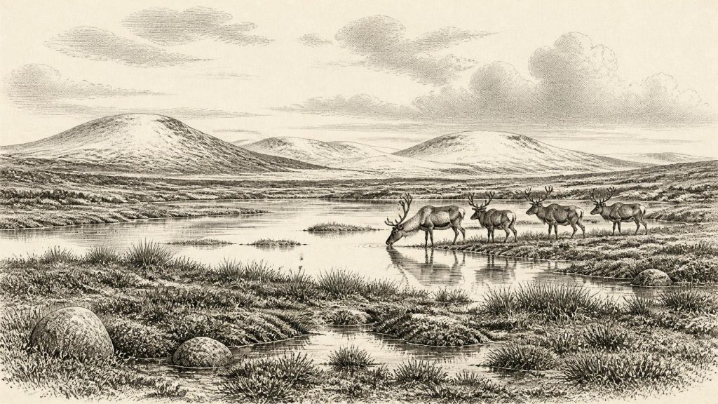
The evidence from the intervening silts is modest in quantity but unusually informative. Poorly preserved pollen was dominated by herbs, while plant macrofossils included a notable moss flora. Grasses, sedges, juniper and other herbaceous plants support an interpretation of open, treeless tundra or muskeg-like wetland. Fossil insects likewise point to wet, plant-rich ground with pools and mossy margins. This was not the later Irish landscape of oak woodland, hazel scrub, pasture, fields and enclosed farms. It was a periglacial environment: one strongly shaped by severe cold, frost action and seasonally frozen ground, although not permanently buried beneath ice.
‘Tundra’ should not conjure a blank white wilderness. At Derryvree, freshwater sediment could settle; shallow water supported aquatic and marginal plants; insects found habitats among decaying vegetation; and a brief growing season could produce a low but functioning food web. Dry patches may have carried sparse herb and grass cover, while depressions remained waterlogged. The evidence does not permit a detailed map of every plant community. A few grains of pine or hazel pollen, for example, are not sound proof of nearby woodland: they may have travelled long distances or been redeposited. What is secure is the larger pattern of open vegetation and cold wetland.
Ice, Water and Changing Ground
At this date, climate was not stable even by Ice Age standards. Greenland ice-core records show abrupt alternations between colder stadials and relatively milder interstadials across MIS 3. Irish cave deposits provide an independent indication that these shifts reached the Atlantic edge of Europe. At Crag Cave in County Kerry, uranium-thorium dating shows that calcite speleothems formed episodically during MIS 3. Because water must remain liquid to circulate through a shallow cave and deposit calcite, these growth phases indicate episodes without persistent permafrost at that site. They do not demonstrate warm modern conditions, nor do they date Derryvree directly; rather, they confirm that the Irish climate could change sharply within the broader cold stage.
The contrast between Derryvree’s freshwater basin and Crag Cave’s intermittent calcite is valuable. One is a northern lowland deposit later enclosed by glacial sediments; the other is a south-western cave archive protected from much surface erosion. Together they show why a simple image of Ireland as either wholly frozen or wholly habitable is misleading. Local topography, elevation, drainage, the direction of ice movement and the timing of climatic shifts all mattered. Ice expanded and contracted over long periods, while water continued to shape those places temporarily beyond, beneath or beside its margins.
Animals in a Sparse Landscape
Irish cave collections offer a second, more fragmentary source of evidence. Their bones indicate that a recognisable northern European Ice Age fauna reached Ireland during parts of MIS 3. Castlepook Cave near Doneraile, County Cork, is particularly important. Reassessment of its old collections, using improved radiocarbon pretreatment, has confirmed the antiquity of some fauna and highlighted the risks of relying uncritically on early dates. Mammoth, giant deer, reindeer, spotted hyaena, Arctic fox and lemming are among the animals represented in Ireland’s late Pleistocene record, though not all specimens are contemporary and no single cave assemblage represents one living community.
Around 31,390 BCE, reindeer and other grazing animals are plausible inhabitants of open Irish environments, but their precise ranges, herd sizes and seasonality remain unknown. Carnivores complicate the record further. Cave hyaenas and other scavengers could drag bones into chambers; water, collapse and later disturbance could move them again. A cave bone is often firm evidence that an animal lived in the wider region, but it is not automatically proof of where it died, how it was deposited, or which animals encountered one another. The most useful conclusion is ecological: parts of Ireland supported enough vegetation and prey to be entered by mobile large mammals and their predators during suitable phases of MIS 3.
The Castlepook Human Question
One reindeer femur from Castlepook has enlarged the question of people in Ice Age Ireland. Ruth Carden has interpreted a deep modification on the bone as a cut or chopping mark made by a sharp stone implement while the bone was fresh. Public heritage material dates the reindeer to about 31,000 BCE. If the interpretation of human modification is upheld, it would be potentially the earliest evidence that people handled an animal in Ireland, far earlier than the securely evidenced post-glacial hunter-gatherer record.
Its importance should be matched by caution. The specimen derives from an old cave collection, excavated before modern recording standards, rather than from a newly excavated occupation surface with a securely associated hearth and stone tools. A date on a bone establishes the animal’s age, not necessarily the exact time when a mark was made. Nor can one modified bone establish a camp, a permanent population, a migration route, repeated hunting expeditions or descent from an Ice Age community. Recent work at Castlepook has sought undisturbed deposits and better contextual evidence, precisely because the claim demands rigorous testing. At 31,390 BCE, human presence in Ireland remains a serious possibility raised by limited evidence, not an established population history.
No Polities, but a Humanly Relevant Landscape
There is consequently no responsible basis for describing political affairs, diplomacy, territorial rule, warfare, religion, formal learning or trade networks in Ireland at this date. No monuments, graves, art, houses, tools, food stores or exchange goods can be securely attributed to an Irish society of c. 33,340 cal BP. It would be equally misleading to project later Gaelic identities, farming communities or even well-documented Mesolithic lifeways backwards into this far older world.
Yet the absence of such evidence is itself historically significant. Ireland’s surviving record for this phase is chiefly environmental because subsequent glaciers scoured, buried and rearranged much of the land surface. What remains makes a powerful case for a dynamic rather than empty island: cold pools beneath a future Fermanagh drumlin, sparse moss-and-sedge wetlands, cave fauna in Cork, and episodes of liquid water in a Kerry cave. These traces tell of a landscape able, at intervals, to sustain life at Europe’s Atlantic margin. They do not tell us that a community watched those pools in 31,390 BCE. They establish the narrower, more valuable conclusion that Ireland around this point belonged to a changing Ice Age world in which ice, water, vegetation and animals continually redrew the possibilities for any human visitor.
Primary Sources
- Palaeoecology
- A Middle Midlandian freshwater series at Derryvree, Maguiresbridge, County Fermanagh, Northern Ireland
- Irish Pleistocene biostratigraphy
- A reconsideration of the radiocarbon dating of the Marine Isotope Stage 3 fauna from southern Ireland
- The Irish Quaternary Fauna Project
- Episodic speleothem deposition tracks the terrestrial impact of millennial-scale last glacial climate variability in SW Ireland
- Spatio-temporal dynamics of speleothem growth and glaciation in the British Isles
- Growth and retreat of the last British–Irish Ice Sheet, 31,000 to 15,000 years ago: the BRITICE-CHRONO reconstruction
- Last Glacial Maximum cirque glaciation in Ireland and implications for reconstructions of the Irish Ice Sheet
- Timing and pace of ice-sheet withdrawal across the marine–terrestrial transition west of Ireland during the last glaciation
- Maximum extent and readvance dynamics of the Irish Sea Ice Stream and Irish Sea Glacier since the Last Glacial Maximum
- The deglaciation of the western sector of the Irish Ice Sheet from the inner continental shelf to its terrestrial margin
- The Last Glacial Maximum
- The IntCal20 Northern Hemisphere Radiocarbon Age Calibration Curve (0–55 cal kBP)
- The IntCal20 Northern Hemisphere radiocarbon age calibration curve (0–55 cal kBP)
- Heritage Artefacts of County Cork
- Archaeology Research Excavation Grant 2022
- Archaeology Research Excavation Grant Report: Castlepook Caves Project
- 32564: Castlepook Cave, Castlepook South, County Cork
- Mell Flint Flake
- Stone Age
- The Mesolithic in Ireland: when was it?
- New insights on the fauna of Ireland's Younger Dryas and Early Holocene from Alice & Gwendoline Cave
- The Quaternary of Ireland