Hyenahall’s Fanged Archive31127 BCE
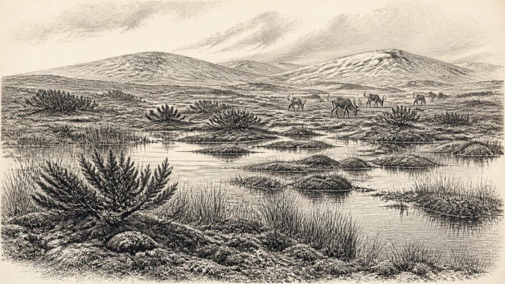
The label 31,127 BCE denotes a broad Late Pleistocene horizon, not a recoverable Irish year. At Derryvree, County Fermanagh, organic wetland sediments between glacial tills, radiocarbon dated broadly to this period, preserve evidence of cold, open tundra-like terrain with pools, sedges, mosses, juniper and bogbean. They demonstrate fluctuating ice conditions before the Last Glacial Maximum. Castlepook Cave, County Cork, contains a diverse cold-stage fauna, including mammoth, reindeer, giant deer, bear and spotted hyena, but its bones span millennia. A possibly cut-marked reindeer bone suggests human visitation, not settlement. Evidence supports ecological reconstruction, while excluding claims of society, politics or culture.
Dateline
A Calendar Label, Not a Dated Year
“31,127 BCE” is a modern calendar label, not a year that can be recovered from the Irish archaeological record. No writing, settlement sequence or scientific measurement permits events in Ireland to be fixed to a particular twelve-month period so far back. The date corresponds approximately to 33,076 calendar years before AD 1950, within the Late Pleistocene and Marine Isotope Stage 3 (MIS 3), an unstable phase of the last Ice Age. It is therefore more responsible to describe a broad environmental and archaeological horizon than to invent a ruler, battle, migration or local incident.
The closest especially useful evidence comes from Derryvree near Maguiresbridge, County Fermanagh. Organic material there produced the radiocarbon determination BIRM-166, conventionally dated to 30,500 radiocarbon years before present, with a substantial laboratory uncertainty. Radiocarbon years are not calendar years: atmospheric carbon-14 has varied over time, so measurements must be calibrated against internationally maintained curves. Published treatments place the Derryvree deposit broadly at about 36,900–31,700 calibrated years before present, roughly 34,950–29,750 BCE. The assigned year lies within that wide span, but it cannot be attached to a particular season, animal, human visit or event.
This distinction is not a technical footnote. It determines what can honestly be said. Ireland around this point was part of a changing north-west European world, but its evidence is thin, locally preserved and unevenly dated. The story is written in buried mud, pollen, seeds, insects, cave bone and glacial sediment rather than in chronicles.
Derryvree Between the Tills
Roadworks at Derryvree in 1969 cut through a drumlin, exposing a remarkable sequence. Beneath one mass of till – the unsorted clay, stones and debris deposited by glacier ice – lay freshwater silts, fine sands and organic mud. Another till sealed the deposit above. The order records a large environmental rhythm: ice had crossed the district; afterwards, open water and wet ground persisted long enough for sediment and vegetation to accumulate; later ice advanced and buried the wetland.
That sequence does not mean that all Ireland was ice-free at once, nor that Fermanagh’s conditions prevailed unchanged from Cork to Donegal. It does, however, show that this part of the island experienced an interval without glacier cover before the great expansion of the last British–Irish Ice Sheet. Later ice was destructive as well as depositional, scouring away many older land surfaces and leaving the surviving records fragmented. Derryvree matters precisely because its organic layer was protected beneath later glacial material.
The plants and small creatures trapped in its sediments point to a cold, open, largely treeless wetland or muskeg-like setting. Grasses, sedges, herbs, juniper and mosses are more appropriate to the reconstruction than later Irish woodland. A seed of bogbean (Menyanthes trifoliata) is particularly eloquent evidence for freshwater margins. Insect remains and aquatic material indicate pools, saturated ground and plant-rich shallow water. Such findings support a picture of low vegetation broken by wet hollows and channels, with local shelter and water making small ecological refuges possible even in a severe climate.
“Tundra” is a useful shorthand, provided it is not imagined as a featureless snowfield. The evidence suggests a patchwork of damp vegetation, open pools, exposed mineral ground and seasonally frozen soils. Winters were probably harsh and biological productivity limited; summers could nevertheless sustain mosses, sedges and aquatic plants. The landscape was unfamiliar in appearance but not lifeless.
An Island Before the Maximum Ice
At this time Ireland was not yet at the Last Glacial Maximum, the later phase when ice expanded extensively across the island and onto surrounding shelves. The maximum extent of the last British–Irish Ice Sheet is generally placed thousands of years after the Derryvree interval, principally within MIS 2 rather than MIS 3. This matters because the phrase “Ice Age Ireland” can otherwise imply permanent, uniform ice cover. The geological evidence instead records advances, retreats and ice-free or less glaciated intervals, differing by region.
Climate across the North Atlantic was also highly variable on millennial scales. Greenland ice cores register abrupt shifts between colder stadial and relatively milder interstadial conditions. Irish deposits cannot automatically be matched to a single Greenland event, since their chronological resolution is far lower and regional responses could lag or differ. Yet Derryvree’s freshwater sediments, together with episodes of speleothem growth in Crag Cave, County Kerry, fit the wider conclusion that the later Ice Age was punctuated by environmental change rather than an unbroken deep freeze.
Sea levels were lower than today because much water was held in global ice sheets. Ireland’s precise coastlines and connections to Britain shifted through the Pleistocene, but there is no basis for drawing a simple, fixed land bridge across the Irish Sea for this particular date. Animal and possible human movements must be considered against changing seas, exposed shelves and short sea crossings, not assumed from a modern map.
Cave Bones and Predators
Southern Ireland offers another, very different archive. Castlepook Cave, also called Mammoth Cave, near Doneraile in County Cork, is the richest known Irish site for vertebrate remains from the period leading towards the Last Glacial Maximum. Excavations recovered more than 2,000 bones. Radiocarbon dates from individual remains cover a long interval, approximately 45,700 to 19,950 years before present. The cave is consequently evidence for a broad cold-stage animal world, not a photograph of one moment in 31,127 BCE.
Its fauna includes woolly mammoth, giant deer, reindeer, brown bear and spotted hyena; later material also includes Arctic fox, wolf and lemmings. The range demonstrates that Ireland was reached by mammals adapted to cold, open country, alongside formidable predators and scavengers. A spotted-hyena skull from the cave is held by the National Museum of Ireland. Hyenas are especially important because their bones, droppings and feeding behaviour complicate interpretation: caves can be dens, traps, shelters, water-transported repositories and places where carnivores carried prey remains.
Thus a bone in a cave does not straightforwardly record a local hunt, a dwelling or even the exact spot where the animal died. It does show that Ireland formed part of wider ecological routes in which large herbivores and carnivores could move through, or periodically occupy, suitable landscapes. Reindeer in particular evoke a mobile grazing resource, but the Irish record cannot establish the size, regularity or routes of herds in any individual year.
The Human Question
The most provocative object from Castlepook is a reindeer femur bearing a deep surface mark interpreted by some researchers as a cut or chop made on fresh bone with a sharp stone tool. Its reported antiquity has encouraged the possibility that people reached Ireland around 33,000 years ago. If the mark is anthropogenic, it would be an important indication of carcass processing during the Upper Palaeolithic era.
But the limits of the claim are as important as its excitement. The bone’s date is the date of the animal, not automatically that of a human action. The cave deposits have been disturbed by water, animals and earlier excavation, and Ireland has not produced a securely excavated camp, hearth, house floor, human bone or unequivocal contemporary stone-tool assemblage for this horizon. A single modified bone, even if the interpretation proves correct, would indicate a visit or episode of butchery; it would not demonstrate permanent settlement, a resident population or continuous occupation.
Accordingly, political affairs, diplomacy, warfare and institutions are beyond the evidence. There are no named communities, chiefs, territories, alliances or conflicts. Nor is there secure evidence for religion, ritual, art, language or formal learning. It is possible that visiting hunter-gatherers elsewhere in north-west Europe possessed rich social knowledge, technical traditions and beliefs, but these cannot responsibly be assigned to Ireland without Irish evidence.
Subsistence Without a Society
Economy and everyday life can only be discussed conditionally. The wetland and cave records show resources that people could have used if they were present: reindeer and other mammals, freshwater, plant materials and sheltered limestone terrain. They do not prove that these resources were harvested, traded or managed by humans in Ireland. No evidence supports farming, metalworking, pottery, long-distance commerce or settled villages. The conventional language of economy should therefore give way to ecology: animal movement, forage, predation, water and seasonal survival.
There was likewise no Irish political map. The meaningful regional change was environmental. In Fermanagh, a freshwater tundra wetland accumulated between glacial episodes. In Munster, cave assemblages preserve an unexpectedly diverse cold-stage fauna. Around the island, later ice would remould hills, plains and drainage, while lower seas changed the wider setting through which animals – and perhaps occasional people – might travel.
The most important development around this notional date was not an event recorded in a year. It was the persistence of life in a cold and volatile Irish landscape before the last ice sheet reached its fullest extent. Derryvree’s plants and pools, and Hyenahall’s bones, make that landscape tangible. They also impose discipline: the evidence permits a rich ecological history, but not an invented human chronicle.
Primary Sources
- A Middle Midlandian Freshwater Series at Derryvree, Maguiresbridge, County Fermanagh, Northern Ireland
- The Subdivision of the Quaternary Period in Ireland
- Exploring Controls of the Early and Stepped Growth of the British–Irish Ice Sheet during the Last Glacial Cycle
- Episodic Speleothem Deposition Tracks the Terrestrial Impact of Millennial-Scale Climate Variability during Marine Isotope Stage 3
- Cork County Geological Site Report: Castlepook Cave
- Spotted Hyena Skull
- The Irish Quaternary Fauna Project
- New Insights on the Fauna of Ireland’s Younger Dryas and Early Holocene from Alice & Gwendoline Cave
- The IntCal20 Northern Hemisphere Radiocarbon Age Calibration Curve (0–55 cal kBP)
- A Stratigraphic Framework for Abrupt Climatic Changes during the Last Glacial Period Based on Three Synchronized Greenland Ice-Core Records
- Maximum Extent and Dynamic Behaviour of the Last British–Irish Ice Sheet West of Ireland
- Pattern and Timing of Retreat of the Last British-Irish Ice Sheet
- Reconstructing the Last Irish Ice Sheet 2: A Geomorphologically-Driven Model of Ice Sheet Growth, Retreat and Dynamics
- Trimlines, Blockfields and the Vertical Extent of the Last Ice Sheet in Southern Ireland
- Dynamic Cycles, Ice Streams and Their Impact on the Extent, Chronology and Deglaciation of the British-Irish Ice Sheet
- Quaternary Data and Maps
- Learn About: The Ice Age
- Pleistocene Vertebrates in the British Isles
- Irish Pleistocene Biostratigraphy
- Menyanthes trifoliata
- Freshwater Organic Deposits and Stratified Sediments Between Early and Late Midlandian Till Sheets, at Aghnadarragh, County Antrim, Northern Ireland
- The Nature and Timing of MIS 3 Interstadials: New Constraints from U-Series Dated Speleothems from Crag Cave, South-West Ireland
