
Maguirebridge’s Intertill Pools30549 BCE
Around 30,549 BCE, Ireland has no documented human or political history, but Derryvree near Maguiresbridge, County Fermanagh, preserves a rare Middle Midlandian environmental record. Organic freshwater silts between glacial tills, radiocarbon dated broadly to this period, show a locally ice-free cold wetland amid fluctuating glaciation. Sedges, grasses, mosses, herbs, aquatic plants and Arctic-alpine species occupied treeless, waterlogged ground with harsh winters and short summers. Later ice sealed the deposits. Cave remains indicate that cold-adapted mammals, including mammoth, reindeer and hyaena, occurred in Ireland during the wider period, but cannot prove human settlement, activity or reliable routes to the island there.
Dateline
“30,549 BCE” is a modern chronological label, not a date at which an event can be identified in the Irish record. No written sources, named communities, political boundaries or calendar-year narratives exist for Ireland at this depth of time. The responsible approach is instead to ask what evidence has survived from the broad period containing that year. The most informative Irish evidence is environmental: sediments, plant remains, insects, animal bones and the traces of advancing and retreating ice. Together they place Ireland within the Middle Midlandian, part of the last glacial cycle, during a cold and unstable Late Pleistocene world.
Modern calendar precision is impossible. The key date comes from Derryvree near Maguiresbridge, County Fermanagh, where organic freshwater deposits produced radiocarbon determination BIRM-166, conventionally reported as 30,500 ± roughly 1,100 radiocarbon years before present. A radiocarbon age is not a calendar age. When calibrated, it corresponds broadly to about 36,900–31,700 calibrated years before present, or approximately 34,950–29,750 BCE. The nominal year 30,549 BCE falls inside that wide range, but cannot be attached to a particular season, generation, animal or human action. Derryvree therefore illuminates conditions around this date, rather than documenting the year itself.
Fresh Water Between the Tills
Derryvree is exceptional because later ice preserved rather than entirely erased a brief environmental archive. Roadworks cut through a drumlin and exposed a sequence in which organic-rich freshwater silts and fine sands lay between two thick deposits of till, the unsorted debris left directly by glacier ice. The order is clear even where the absolute chronology remains broad: ice had occupied the locality; a colder but non-glacial interval then allowed water, sediment and organic matter to accumulate; later ice covered and sealed the deposits.
This is not evidence for an ice-free Ireland in its entirety. It is direct evidence for ice-free conditions at one Fermanagh locality during the lifespan of the deposit. The island’s glaciers were neither static nor necessarily synchronous. Uplands, coastal shelves, lowlands and marine basins responded differently as the British–Irish Ice Sheet grew. At roughly this stage of the wider glacial cycle, regional reconstructions indicate expansion from separate ice centres and considerable uncertainty over the exact margins. Ireland should therefore be envisaged as a geographically varied place: locally open ground and freshwater habitats in some areas, growing ice elsewhere, and coastlines profoundly unlike those of today because sea level and ice loading were changing.
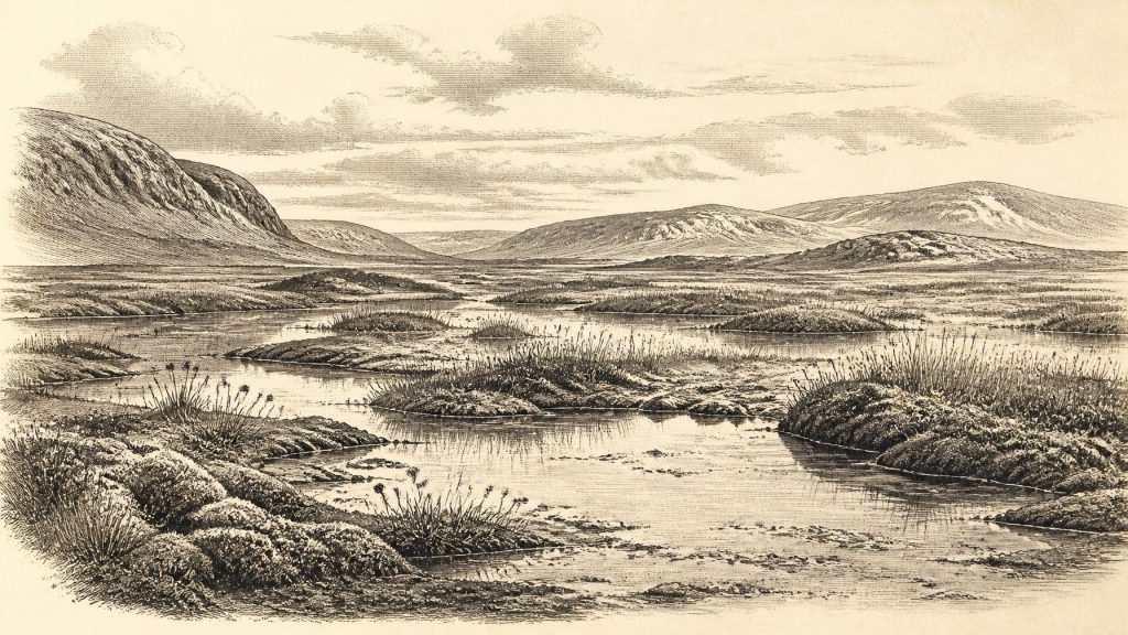
The Derryvree layers have often been described as a treeless muskeg or tundra wetland. The language is useful provided it is not mistaken for a precise modern analogue. Pollen, plant macrofossils, mosses and insect remains indicate cold, open, waterlogged ground, with shallow or slow-moving fresh water and wet margins. Sedges, grasses, mosses and low-growing herbs formed the principal vegetation. Aquatic and wetland plants demonstrate that pools and vegetated shallows existed despite harsh winters. Arctic-alpine elements, including mountain avens, are particularly important: they show that exposed, cold-ground communities could thrive beside the waterlogged basin.
A Severe but Living Landscape
The survival of freshwater plants should not be read as evidence of mild conditions. Derryvree’s assemblage points to a landscape with a short productive season, cold winters and little or no tree cover. Permafrost may have affected nearby ground, while seasonal thaw would have produced saturated soils, standing water and unstable sediment. Summer light and thaw could nevertheless support a burst of plant growth. A patchwork of open mineral ground, mossy wetland, sedge margins and pools would have offered different niches across a small area.
The later history of the section explains why it matters so much. Ice returned and deposited the upper till. That renewed advance buried the wetland, turning a former living surface into an archive. Much of Ireland’s older Pleistocene landscape was scoured, reworked or concealed by later glaciation. Derryvree is valuable precisely because it preserves fragile biological evidence where more conspicuous traces, such as soils, campsites or trackways, did not survive. Its lesson is not that this was an unchanging national landscape, but that cold, locally ice-free freshwater environments existed within an increasingly glacial Ireland.
Mammals and Cave Evidence
Animal remains from Irish caves add a second, less tightly dated window onto the broader Middle Midlandian world. Castlepook Cave, near Doneraile in County Cork, has yielded remains attributed to woolly mammoth, reindeer, giant deer, brown bear, wolf, Arctic fox and spotted hyaena. Historic radiocarbon determinations on mammoth and hyaena material suggested an age around 34,000–35,000 radiocarbon years before present. These are not a secure census for 30,549 BCE, and cave collections excavated long ago must be treated cautiously: deposits were disturbed, individual specimens may differ greatly in age, and older radiocarbon methods have sometimes required reassessment.
Even so, the Castlepook assemblage establishes an important point. During parts of the Late Pleistocene before the Last Glacial Maximum, Ireland could sustain, or at least receive, large cold-adapted mammals and formidable carnivores. Mammoth and reindeer evoke open grazing country; hyaena bones and gnawing show that caves could be carnivore dens or places where prey remains accumulated rather than straightforward human sites. The Irish fauna was selective rather than a complete copy of continental Europe. Absences may reflect ecology, temporary access routes, small populations, later destruction of evidence or the limits of recovery. They should not be converted into confident maps of species distribution.
For a year-by-year history, the crucial distinction is between animal presence and human presence. No securely dated settlement, hearth, stone-tool assemblage, dwelling, grave, artwork or human bone demonstrates a resident human community in Ireland around 30,549 BCE. A reindeer femur from Castlepook has been publicised as carrying a possible stone-tool cut mark and as evidence for much earlier human activity. That interpretation remains too limited and insecure to support a social history of Ireland at this date. It does not establish a camp, a population, repeated visits or an occupation horizon. The earliest published and directly dated evidence widely accepted as indicating human butchery in Ireland is a brown-bear kneecap from Alice and Gwendoline Cave, County Clare, dated much later, to roughly 10,900–10,640 BCE.
No Politics, No Proven Society
Accordingly, there were no recoverable political affairs, conflicts, diplomatic relations or institutions in Ireland in 30,549 BCE. Nor can religion, language, kinship, learning or artistic practice be reconstructed from the Irish evidence. It would be misleading to import the richly documented Upper Palaeolithic societies of continental Europe and assign their beliefs, shelters, clothing or social arrangements to Ireland. Similar climates do not prove similar populations, and Ireland’s insular setting, shifting access routes and sparse record make such borrowing especially hazardous.
If people did reach the island during any part of this broad period, the evidence presently available can say no more than that a short visit or carcass-processing episode is conceivable. Reindeer, mammoth and other large mammals elsewhere in Europe were major resources, providing meat, fat, hides, sinew, bone and antler. But that general European observation is not evidence that these resources were used in Ireland at this time. In the Irish record, subsistence, trade and exchange remain unknown. There is no demonstrated quarrying, farming, fishing technology, sea travel, imported material or enduring settlement to describe.
Routes, Coasts and Regional Change
Lower global sea levels did not automatically create a simple land bridge from Britain to Ireland. Ice sheets, proglacial waters, changing sea basins and local crustal movements complicated the geography. The western seaways and Irish Sea were themselves transformed by ice and changing relative sea level. Fauna could have arrived during favourable windows, but the timing, direction and frequency of movements remain debated. Derryvree provides no direct evidence of a route; Castlepook demonstrates only that animals reached southern Ireland during a broadly relevant phase.
What can be said is that the island was not yet the familiar wooded, agricultural or maritime Ireland of later millennia. Around the date represented by 30,549 BCE, the strongest evidence is for a cold Late Pleistocene environment in flux: freshwater pools near Maguiresbridge, low vegetation exposed to severe seasonal conditions, large mammals appearing in the wider record, and glaciers whose advance would later entomb the Derryvree wetland. The history of this moment is therefore environmental before it is human. Its principal actors are ice, water, plants, animals and geological change, while human history in Ireland remains, at best, unproven.
Primary Sources
- A Middle Midlandian Freshwater Series at Derryvree, Maguiresbridge, County Fermanagh, Northern Ireland
- Early Midlandian–Middle Midlandian, Pleistocene, Northern Ireland
- Quaternary Deposits and Glacial Stratigraphy in Ireland
- The Quaternary of Northern Ireland: Field Guide
- Exploring Controls of the Early and Stepped Deglaciation on the Western Margin of the British Irish Ice Sheet
- Trimlines, Blockfields and the Vertical Extent of the Last Ice Sheet in Southern Ireland
- Growth and Retreat of the Last British–Irish Ice Sheet, 31,000 to 15,000 Years Ago: the BRITICE-CHRONO Reconstruction
- The Deglaciation of the Western Sector of the Irish Ice Sheet from the Inner Continental Shelf to its Terrestrial Margin
- New Data for the Last Glacial Maximum in Great Britain and Ireland
- Dimensions and Chronology of the Last Ice Sheet in Western Ireland
- Timing and Pace of Ice-Sheet Withdrawal Across the Marine–Terrestrial Transition West of Ireland During the Last Glaciation
- The Irish Quaternary Fauna Project
- First Evidence of a Late Upper Palaeolithic Human Presence in Ireland
- New Insights on the Fauna of Ireland's Younger Dryas and Early Holocene from Alice & Gwendoline Cave
- The Mesolithic in Ireland: When Was It?
- Heritage Artefacts of County Cork
- Pleistocene Vertebrates in the British Isles
- Sea Level and Global Ice Volumes from the Last Glacial Maximum to the Holocene
- The Last Eurasian Ice Sheets – a Chronological Database and Time-Slice Reconstruction, DATED-1
- Conserving Quaternary Geoheritage in Northern Ireland
