

Derryvree’s Road-Cut Wetland30483 BCE
Labelled 30,483 BCE, this period cannot be dated annually and is understood through Late Pleistocene geological and fossil evidence. At Derryvree, County Fermanagh, freshwater silts and organic deposits lay between glacial tills, recording a locally ice-free wetland interval before renewed glaciation. Plant remains, mosses and insects indicate a cold, treeless mosaic of shallow water, sedges, herbs, grasses and sparse shrubs. Cave fauna elsewhere suggests diverse cold-stage animals, though not necessarily contemporaneous locally. Human residence remains unproven; a modified Castlepook reindeer bone may indicate a brief visit. Derryvree predates the Last Glacial Maximum, demonstrating ecological life between ice advances in Ireland.
Dateline
“30,483 BCE” is a modern calendar label, not a year that can be recovered from an Irish chronicle, settlement layer or individual lifetime. At this depth in time, no annual precision is available. The date falls roughly 32,432 years before the conventional radiocarbon baseline of AD 1950, within the Late Pleistocene and Marine Isotope Stage 3 (MIS 3), an unstable phase of the last Ice Age. Ireland at this point must be approached through geological sequences, fossil plants and insects, animal bones, and radiocarbon measurements with wide uncertainties—not as a conventional historical year.
The most informative Irish evidence comes from Derryvree, near Maguiresbridge in County Fermanagh. There, road construction in 1969 exposed a remarkable deposit within a drumlin: freshwater silts and fine sands, including organic material, lying between two distinct layers of glacial till. The organic horizon produced the radiocarbon determination Birm-166, 30,500 radiocarbon years BP, with a substantial uncertainty. Calibration does not transform that result into a single calendar year. Modern treatments place it broadly around the later part of MIS 3, often expressed approximately as 36,900–31,700 calibrated years BP, or c.34,950–29,750 BCE. The nominal year considered here lies within that large range, but cannot be attached to a particular bed, season or event.
A Wetland Between Ice Advances
Derryvree’s value lies in its sequence. The lower till shows that glacier ice had previously occupied the locality. Above it, freshwater sediment accumulated in an ice-free or at least locally non-glacial interval. A later till then covered the organic layers, sealing their contents beneath fresh glacial debris. This is firm evidence for changing local conditions in south Fermanagh: ice, then standing or slow-moving freshwater and vegetation, then renewed glacial activity. It is not proof that the whole island was ice-free at precisely the same time, nor a complete map of Irish ice margins.
That caution is important because Ireland’s late Pleistocene history was neither simple nor uniform. Ice masses expanded and contracted across north-west Europe in response to abrupt climatic shifts. Different parts of the British–Irish Ice Sheet could behave differently, and a surviving deposit at one inland site cannot settle the condition of every coast, upland or sea basin. Yet Derryvree decisively rules out a picture of an unchanging, wholly ice-covered island throughout the entire period. At least during the interval represented by its silts, part of Fermanagh supported freshwater, plants and invertebrates on exposed ground.
Open Ground and Shallow Water
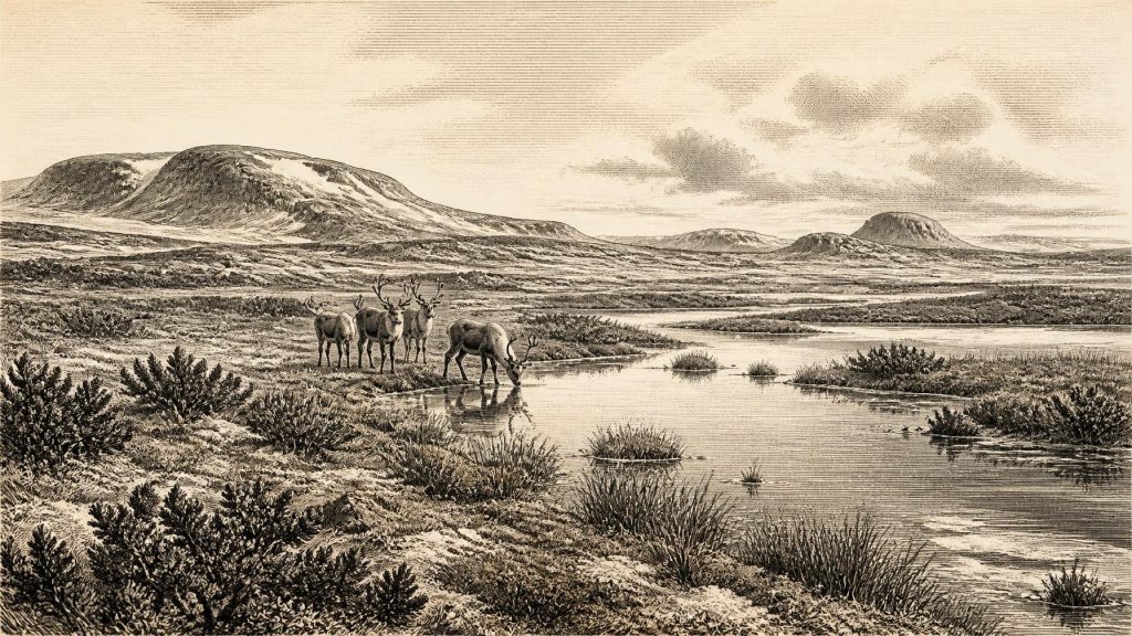
The Derryvree fossils indicate a cold, open and largely treeless landscape. Pollen was poorly preserved, so it is less secure evidence than the plant macrofossils and mosses that were deposited close to where they grew. Taken together with insect remains, however, they point towards grasses, sedges, herbs, moss-rich surfaces and low shrubs, including juniper, rather than forest. Wet hollows and shallow pools occurred alongside drier patches of sparsely vegetated sediment. Researchers have described this kind of setting as tundra or muskeg: a waterlogged, frost-affected mosaic in which plant-rich margins bordered open water.
This was not a uniformly barren wilderness. Short summers could support growth in sheltered or wet places, while decaying vegetation in pools and saturated ground offered habitats for insects and mosses. But the evidence also points to a severe climate, with cold winters, seasonal freezing and thawing, limited tree cover and a short growing season. The Derryvree record therefore gives a more textured image than the phrase “Ice Age” alone: a landscape shaped by cold, but biologically active wherever water, sediment and seasonal warmth allowed life to persist.
Animals in a Changing Island
Other Irish sites provide a broader, though not perfectly synchronous, faunal context. Cave deposits at Castlepook near Doneraile, County Cork have yielded remains attributed to mammoth, reindeer, giant deer, brown bear, wolf, Arctic fox, lemmings and spotted hyaena. These animals do not demonstrate that all occupied Fermanagh together in 30,483 BCE. Cave assemblages can accumulate over long periods, and carnivores, water movement, excavation history and later disturbance may affect what survives. Nevertheless, they show that Ireland supported, or was visited by, a notably varied cold-stage fauna during the wider middle and later parts of the last glacial cycle.
The most useful interpretation is ecological rather than dramatic. Reindeer and lemmings are consistent with open, cold environments; mammoth and giant deer indicate that extensive feeding grounds existed at least in some periods and regions; hyaenas and wolves reveal a predator and scavenger guild. Animal movement would have depended on shifting terrain, changing vegetation and access across the wider Irish Sea region. Lower sea levels altered coastlines, but neither the Derryvree deposit nor the cave fauna permits a confident reconstruction of a particular shoreline or crossing route for this notional year.
The Human Question
No securely excavated dwelling, hearth, cemetery, tool-making floor or settlement of this age is known in Ireland. Consequently, there is no responsible basis for describing an Irish polity, tribe, language, religion, artistic tradition, trade network or system of leadership in 30,483 BCE. There are no political affairs, diplomacy or organised conflict available to historical study, and no evidence for farming, livestock keeping, metalworking, monuments or long-distance commerce on the island at this date.
One cave find makes the absence of stronger evidence especially significant. A reindeer femur from Castlepook has been publicised as bearing a modification interpreted as a cut or chop made with a sharp stone implement, and as dating to about 33,000 years ago. If that interpretation is sustained by continuing research, it may represent an exceptionally early sign of human activity in Ireland: the processing of one animal carcass. It would not, however, demonstrate permanent occupation. The bone derives from old cave excavations with limited modern stratigraphic control, and it has not been accompanied by a published settlement assemblage. The appropriate conclusion is that a brief human visit is possible, while a resident community remains unproven.
No Society Yet Recoverable
For a general history, the distinction between evidence and interpretation matters greatly. The fossil record can illuminate environment, animal communities and the chronology of ice advances. It cannot recover everyday social life where people themselves are not securely demonstrated. We do not know whether humans saw the Derryvree wetland, hunted its animals, travelled through the area or left traces later destroyed by glaciation. Nor can absence of evidence establish that no person ever reached Ireland. Much of the relevant landscape has been eroded, buried, drowned by post-glacial sea-level rise or obscured beneath later sediments.
What can be said is narrower, but still remarkable. Ireland occupied the far north-western edge of the European world during a climatically volatile period. In south Fermanagh, a freshwater wetland developed between episodes of glacier occupation. Mosses, herbs, sedges, insects and shallow water formed a living local environment in a cold, treeless setting. Elsewhere, large herbivores and predators moved through changing habitats. The island was not yet the wooded and settled Ireland of later millennia; it was a landscape in which ice, water, frost and mobile animal life were the principal historical forces.
Approaching the Last Glacial Maximum
The Derryvree interval preceded the global Last Glacial Maximum, generally dated to about 26,500–19,000 calibrated years BP. During that later period, the British–Irish Ice Sheet became much more extensive, and Ireland was predominantly glaciated. The wetland at Derryvree is therefore important partly because later ice preserved it while also removing much other evidence. Its silts record an episode before the island’s most extensive late-glacial ice cover, when local ecological niches still existed between glacial phases.
Thus the history of Ireland around 30,483 BCE is not the history of a named event. It is the history of a buried wetland, an uncertain but potentially consequential animal bone, and the changing reach of ice. Derryvree provides the clearest Irish window: not a diary of a single year, but durable evidence that cold-stage Ireland contained open ground, freshwater and life before the later ice sheet transformed the island again.
Primary Sources
- A Middle Midlandian Freshwater Series at Derryvree, Maguiresbridge, County Fermanagh, Northern Ireland
- Palaeoecology
- The Subdivision of the Quaternary Period in Ireland
- The Geology of Ireland: Cenozoic, Tertiary and Quaternary
- Deglacial Rates and Controls for the British-Irish Ice Sheet Western Margin
- A Reconsideration of the Radiocarbon Dating of the Marine Isotope Stage 3 Fauna from Southern Ireland
- The Irish Quaternary Fauna Project
- The Colonization of Ireland: A Human Ecology Perspective
- Timing and Pace of Ice-Sheet Withdrawal Across the Marine–Terrestrial Transition West of Ireland During the Last Glaciation
- Trimlines, Blockfields and the Vertical Extent of the Last Ice Sheet in Southern Ireland
- Dimensions and Chronology of the Last Ice Sheet in Western Ireland
- Red Deer (Cervus elaphus) in Ireland: Genetic and Osteological Evidence for a Complex History
- First Evidence of a Late Upper Palaeolithic Human Presence in Ireland
- Archaeology Research Excavation Grant 2022: Final Report
- Heritage Artefacts of County Cork
- The Geological Heritage of County Leitrim
- Freshwater Organic Deposits and Stratified Sediments Between Early and Late Midlandian (Devensian) Till Sheets, at Aghnadarragh, County Antrim, Northern Ireland
- The Late Quaternary History of East-Central Ireland
- The Last Glacial Maximum
- The IntCal20 Northern Hemisphere Radiocarbon Age Calibration Curve (0–55 cal kBP)
- Landscapes and Environments of the Last Glacial-Interglacial Transition: A Time of Amazingly Rapid Change in Ireland
- Pleistocene Vertebrates in the British Isles





