
Birm-166’s Freshwater World31607 BCE
31,607 BCE is an imprecise modern label within a Late Pleistocene range, not a recoverable Irish date. At Derryvree, County Fermanagh, organic freshwater silts, sealed between glacial tills, record an ice-free Middle Devensian interval before ice expansion. Pollen, plants, mosses and insects reveal cold, treeless, tundra-like wetland and open ground, with pools, sedges, grasses, juniper and herbs. Fragmentary cave fauna elsewhere, Castlepook, indicates northern animals including reindeer, mammoth, giant deer and hyaena, but not a simultaneous community. No secure evidence establishes human settlement; a possibly cut-marked reindeer bone suggests only unconfirmed, fleeting human activity. Derryvree preserves a rare environmental archive.
Dateline
31,607 BCE is a modern calendar label, not a date that can be recovered from Ireland’s prehistoric evidence. No event, person, journey or season can responsibly be assigned to this particular year. In radiocarbon practice, it falls roughly 33,556 years before AD 1950, but prehistoric ages are reported as ranges, with margins of error and calibration rather than as exact BCE years. The most relevant Irish evidence belongs to the Middle Midlandian, or Middle Devensian, part of the Late Pleistocene: a cold and climatically variable interval within Marine Isotope Stage 3, before the Last Glacial Maximum.
The named year lies within the broad calibrated span associated with the famous Derryvree freshwater deposits near Maguiresbridge in County Fermanagh. Their principal radiocarbon measurement, Birm-166, was obtained from organic sediment and reported as 30,500 ± 1,200 radiocarbon years BP. Calibration and subsequent modelling place its possible calendar age across a wide interval, approximately 36,900–31,700 calibrated years BP. That range includes a notional date around 31,607 BCE, but does not turn Derryvree into a record of one particular year. It offers something more valuable: a rare, local environmental archive for an otherwise poorly preserved phase of Ireland’s Ice Age.
A Wetland Between Ice Advances
Derryvree was exposed during road works in 1969, when a cutting passed through a drumlin about two kilometres north-east of Maguiresbridge. Beneath the familiar smooth hill lay two distinct sheets of till, the stony debris deposited by glacier ice. Between them was a layer of fine sands and organic silts formed in freshwater conditions. This sequence matters because the lower till records an earlier glacial episode, while the upper till records later ice advance and burial. The organic layer therefore preserves a period when this part of Fermanagh was not under moving ice.
That is evidence, not a complete map of the island. It demonstrates ice-free ground and freshwater sedimentation at Derryvree during the interval represented by the silts. Together with comparable deposits at Greenagho and elsewhere, it supports the interpretation that substantial areas of north-central Ireland were ice-free before the principal expansion of the last British–Irish Ice Sheet. It does not prove that every coast, valley or upland of Ireland was simultaneously open, nor that the landscape remained stable for centuries. Ice margins, snowfields, rivers and permafrost could have changed rapidly in a climate marked by sharp swings.
The later ice was also a destroyer of evidence. Glaciers eroded bedrock, reworked earlier deposits and covered landscapes with fresh till. The survival of Derryvree’s silts beneath a drumlin is consequently unusual. There were surely other pools, marshes and river margins across Ice Age Ireland, but few have survived in a form that can be dated and studied. The absence of a site is not proof that an environment, animal or human group was absent from the whole island.
The Derryvree Landscape
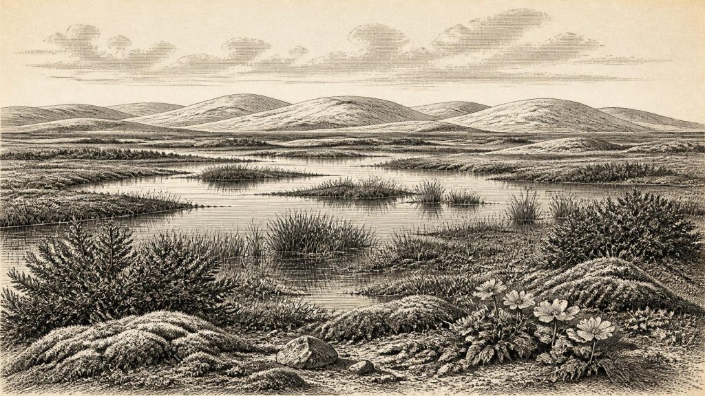
Pollen, plant macrofossils, moss remains and insects recovered from the freshwater sediments give the clearest picture. They indicate a treeless, periglacial landscape rather than a forested Ireland. Grasses and sedges were prominent, accompanied by juniper and a range of herbs adapted to open ground. Mosses flourished around wet ground, while aquatic plants attest to standing or slow-moving water. Fossil evidence includes water-milfoil, the wetland plant bogbean, and mountain avens, whose modern distribution evokes cold, exposed and often calcareous ground.
Researchers have described the setting as muskeg: a cold, waterlogged mosaic of mossy ground, sedge growth and shallow pools rich in plant material. The word should not conjure a single unbroken bog. Derryvree was a local wetland within a broader open landscape, and its sediments over-represent plants growing close to the water. Yet the combined pollen and insect evidence is strong support for sparse woodland or no woodland nearby, short growing seasons and severe winters. The scene was not an empty white waste. During the thaw, pools held aquatic vegetation and wet ground could be productive; in winter, frozen soils and snow would have imposed formidable limits.
Such evidence also warns against imagining present-day Fermanagh simply transplanted into the past. There were no dense hedgerows, improved fields, farm animals, villages, roads or mature oak woodland. The drumlin itself existed as a glacially shaped landform, but its surface and drainage were subject to frost action, seasonal meltwater and changing sediment. The familiar modern patchwork of enclosed green fields belongs to an immensely later agricultural history.
Animals at Ireland’s North-Western Edge
Derryvree has not yielded a matching large-mammal assemblage, so the animal record must be drawn cautiously from other Irish sites and dates. The most important is Castlepook Cave near Doneraile in north County Cork. Its old excavations produced one of Ireland’s richest Pleistocene bone collections: woolly mammoth, reindeer, giant deer, brown bear, wolf, foxes, mountain hare, lemmings and spotted hyaena. These species show that cold-adapted animal communities reached Ireland at various points before and during the approach to the Last Glacial Maximum.
They do not establish a single neat “mammoth-steppe” scene in 31,607 BCE. Castlepook is a cave archive accumulated over a long period. Bones came from complex deposits affected by carnivores, water movement, antiquarian excavation and later disturbance. Improved radiocarbon pretreatment has shown that several early measurements from southern Irish caves were too young, while fresh dating has pushed some specimens much farther back into Marine Isotope Stage 3. A mammoth bone, hyaena tooth and reindeer limb may therefore record different episodes rather than animals that met on the same day or even in the same millennium.
Even so, the faunal record gives a credible sense of ecological possibility. Reindeer and lemmings are consistent with open, cold country; mountain hare, Arctic fox and wolf show the capacity of Irish landscapes to support northern species; mammoth, giant deer and hyaena point to food webs unlike any now surviving on the island. Hyaenas may have used Castlepook as a den, while caves could also trap animals or collect bones washed in from outside. The route by which each specimen entered the cave is part of the scientific question, not a detail to be assumed away.
The Human Question
There is no securely excavated house, hearth, burial, stone-tool assemblage or occupation floor in Ireland that can be dated to around 31,607 BCE. Accordingly, there is no basis for describing a resident population, a named people, a language, a political order or a continuous Upper Palaeolithic settlement of Ireland at this time. Ireland had no states, rulers, diplomacy, warfare in the historical sense, formal religion, writing, schools, markets or trade institutions that can be recovered from the evidence.
A potentially important but unresolved find comes from Castlepook. A reindeer femur from the historic collection has been reported as carrying a mark consistent with cutting by a sharp stone tool during carcass processing, and the bone has been publicised as roughly 33,000 years old. If the mark is confirmed as human-made and contemporaneous with the animal’s death, it would indicate a human encounter with a reindeer in Ireland far earlier than the better-established terminal-Pleistocene evidence from Alice and Gwendoline Cave in County Clare.
That conditional wording is essential. The Castlepook bone was not recovered from a modern, tightly recorded excavation of an occupation surface. A radiocarbon result dates the animal bone, not automatically the mark, a hunter, a camp or a journey. Natural abrasion, carnivore activity, trampling, breakage and excavation damage can all complicate the identification of cut marks. Current work at the cave has located further stratified Pleistocene deposits and may eventually clarify the history of its sediments and bones. For now, the responsible conclusion is possible fleeting human activity, not established settlement.
Life, Movement and What Cannot Be Known
If people did enter Ireland during a favourable interval in Marine Isotope Stage 3, they would most plausibly have travelled in small, mobile groups whose subsistence depended on knowledge of seasonal animals, weather, shelter and stone resources. That is an inference from wider Upper Palaeolithic Europe, not a demonstrated Irish social history. No Irish evidence of this age identifies their numbers, kinship, clothing, beliefs, artistic practices, routes or duration of stay. A single butchered carcass, if that is what Castlepook eventually proves to be, could represent hours rather than generations.
Nor can economy and exchange be reconstructed. Lower sea levels altered the outlines of land and sea around Ireland, while the growth and movement of the British–Irish Ice Sheet repeatedly reshaped possible routes. But a lower sea is not itself proof of a continuous walkable land bridge or of regular traffic. Any movement between Ireland, Britain and continental Europe would have depended on the changing configuration of ice, water, exposed shelf, river valleys and coastlines. At this date, the geography of connection was as unstable as the climate.
The most secure story for this notional year is therefore environmental. Around the broad period into which 31,607 BCE falls, an ice-free window in Fermanagh supported cold freshwater wetlands amid open tundra-like ground. Elsewhere, animals adapted to harsh northern environments ranged through parts of Ireland, leaving fragmentary remains in caves. The following millennia brought more extensive ice growth, transforming and often erasing those landscapes. Derryvree’s organic silts, sealed between tills, remain a small but remarkable survival: not a chronicle of a year, but evidence that Ice Age Ireland was diverse, habitable for specialised life, and far from archaeologically silent.
Primary Sources
- A Middle Midlandian Freshwater Series at Derryvree, Maguiresbridge, County Fermanagh, Northern Ireland
- Irish Pleistocene Biostratigraphy
- The Irish Quaternary Fauna Project
- A Reconsideration of the Radiocarbon Dating of the Marine Isotope Stage 3 Fauna from Southern Ireland
- Castlepook Cave: County Geological Site Report
- Trimlines, Blockfields and the Vertical Extent of the Last Ice Sheet in Southern Ireland
- Exploring Controls of the Early and Stepped Deglaciation on the Western Margin of the British Irish Ice Sheet
- Pattern and Timing of Retreat of the Last British–Irish Ice Sheet
- Growth and Retreat of the Last British–Irish Ice Sheet, 31,000 to 15,000 Years Ago: the BRITICE-CHRONO Reconstruction
- The Timing and Magnitude of the British–Irish Ice Sheet Between Marine Isotope Stages 5d and 2
- The Island of Ireland: Drowning the Myth of an Irish Land-bridge?
- The Colonization of Ireland: A Human Ecology Perspective
- First Evidence of a Late Upper Palaeolithic Human Presence in Ireland
- New Insights on the Fauna of Ireland's Younger Dryas and Early Holocene from Alice & Gwendoline Cave
- The Subdivision of the Quaternary Period in Ireland
- Late Quaternary Landscape Evolution, Palaeoenvironments and Human Occupation in the North of Ireland
- Introduction to the Late Quaternary and Holocene of Northern Ireland
- BSBI: Myriophyllum alterniflorum
- BSBI: Dryas octopetala
- BSBI: Menyanthes trifoliata
- Heritage Artefacts of County Cork
- Archaeological Heritage of County Cork
- Archaeology Research Excavation Grant Report: Castlepook Cave Project
- The Quaternary History of Ireland
- Dimensions and Chronology of the Last Ice Sheet in Western Ireland
