Fermanagh’s Wetland Interlude31126 BCE
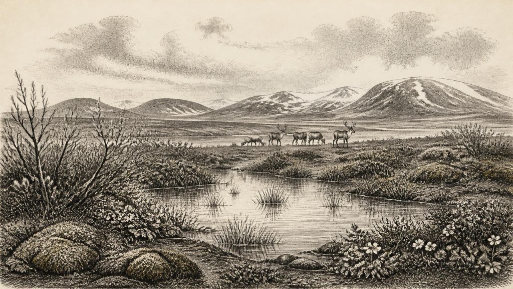
Around 31,126 BCE, Ireland lay within the unstable Late Pleistocene climate of Marine Isotope Stage 3, before maximum glaciation. At Derryvree, County Fermanagh, freshwater silts between glacier deposits, dated broadly to 34,950–29,750 BCE, preserve evidence of a tundra wetland. Sedges, mosses, bogbean, dwarf willow, insects and pollen indicate cold, open, treeless terrain with seasonal water. Cave remains from Castlepook, County Cork, show cold-adapted fauna including mammoth, reindeer, giant deer and predators, although their contemporaneity is uncertain. No secure human settlement is known; a possibly cut-marked reindeer bone suggests only a potential brief Upper Palaeolithic visit. Subsequent ice advance buried them.
Dateline
The label 31,126 BCE gives a useful position in a modern timeline, but it does not describe a year that anyone in Ireland could have named or recorded. There is no written history, calendar, settlement sequence or securely dated event that can be fixed to this particular point. In archaeological terms it is approximately 33,075 years before AD 1950, the conventional present used in radiocarbon chronology. The responsible approach is therefore to examine broad, calibrated ranges and physical evidence rather than inventing a political episode or a prehistoric biography.
This was the Late Pleistocene, within Marine Isotope Stage 3: a severe and climatically unstable part of the last Ice Age, before the Last Glacial Maximum. Ireland was not yet uniformly buried beneath the later great ice sheet. Its landscapes and coastlines were changing in response to colder conditions, lower sea level, shifting snowfields and expanding ice. The evidence is fragmentary because later glaciers eroded, displaced and buried much of what had existed. Yet a few sites, especially in County Fermanagh and north County Cork, allow a careful reconstruction of an Ireland of open country, freshwater hollows and large mammals.
A Date Within a Wide Range
The most important Irish evidence relevant to this date comes from Derryvree, near Maguiresbridge in County Fermanagh. Road works in 1969 cut through a drumlin and exposed fine sands and organic freshwater silts enclosed between two thick deposits of till: the mixed sediment laid down directly by glacier ice. The order of the layers is decisive. Ice had first crossed the locality and deposited the lower till. A later non-glacial interval allowed water, sediment, plants and small animals to accumulate. Then a renewed ice advance sealed the wetland beneath the upper till.
Organic material from the Derryvree bed yielded a conventional radiocarbon determination of about 30,500 radiocarbon years before present, with a substantial uncertainty. Later calibration has placed the deposit broadly at about 36,900–31,700 calibrated years BP, or roughly 34,950–29,750 BCE. The modern date 31,126 BCE falls inside that wide interval. It cannot, however, identify the precise year in which a particular pool existed, a seed was shed or an animal passed by. The deposit is evidence for an environmental phase, not a dated annual chronicle.
Nearby Greenagho, near Belcoo in County Fermanagh, provides an older but complementary indication that north-central Ireland retained ice-free ground before the later expansion of the last Irish Ice Sheet. Together, such sites make a narrow but important point: Ireland’s transition towards full glacial conditions was neither instantaneous nor geographically uniform. At the time represented by the Derryvree range, at least some lowland areas could sustain wet ground and tundra-like vegetation even as colder conditions increasingly constrained life.
Water Beneath the Drumlin
Derryvree is particularly valuable because it preserves biological remains as well as sediment. Plant macrofossils, pollen, mosses and beetle remains indicate a cold, open and largely treeless environment. Sedge-rich wetland, mossy ground and shallow freshwater pools were embedded in a broader periglacial landscape: one shaped by repeated freezing and thawing close to an ice margin. The fossil record includes bogbean, Menyanthes trifoliata, an aquatic plant of marshes and slow water, as well as dwarf willow, mountain-avens and other plants suited to exposed cold conditions.
This should not be imagined as a featureless white desert. In favourable hollows, water could remain available during the growing season; plants rooted in saturated sediment; insects found food and shelter; and birds or mammals could have used the surrounding ground. But nor was it a forested Ireland of later millennia. The assemblage points to sparse vegetation, short productive summers, severe winters and a landscape in which local shelter mattered greatly. The apparent contrast between wet pools and frost-hardened open ground is one of the clearest impressions supplied by the evidence.
The ecology is reconstructed from proxy evidence, rather than observed directly. A seed establishes that a species grew nearby or was transported into the deposit; beetle remains illuminate habitat and temperature tolerances; pollen suggests vegetation at a wider scale. None yields a complete map. Even so, their convergence supports the interpretation of Derryvree as a freshwater muskeg or tundra wetland, not a temperate woodland. The wetland itself was temporary on a geological scale, destined to be overridden and entombed as ice conditions changed again.
Animals of the Open Country
Animal bones from Irish caves show that the island supported, or was intermittently reached by, a far richer Ice Age fauna than survives today. Castlepook Cave, also known as Mammoth Cave, near Doneraile in north County Cork is the principal site. Its deposits have produced remains of woolly mammoth, reindeer, giant deer, brown bear, wolf, Arctic fox, lemmings and spotted hyaena. These animals evoke open grazing country and a food web that included large herbivores, carnivores and scavengers.
There are important limits. Castlepook is a cave repository accumulated through varied processes over a long span of time, and later water disturbance has mixed parts of the record. Individual bones have yielded dates ranging across much of the middle and later Ice Age; they do not demonstrate that every named species lived together in one valley, let alone in 31,126 BCE. Improved radiocarbon pretreatment has also shown that several older determinations from Irish cave faunas needed revision. The strongest conclusion is deliberately modest: during Marine Isotope Stage 3, Ireland contained or received cold-adapted animals capable of exploiting open habitats, but their precise local ranges and contemporaneity remain uncertain.
Reindeer are especially relevant to the Derryvree-type landscape. They were mobile grazers well suited to open, seasonal country, while mammoths and giant deer required substantial forage. Their presence in the wider Irish record implies that parts of the island were biologically productive despite harsh climate. Spotted hyaena bones and coprolites from Castlepook also demonstrate that predators or scavengers entered this world. Caves may have been dens, traps, scavenging sites or places where water and sediment concentrated bones; they should not be treated as tidy snapshots of a living community.
The Human Question
There is no securely excavated settlement, hearth, dwelling, burial or stone-tool assemblage in Ireland that can be assigned to 31,126 BCE. Political affairs, diplomacy, institutions, named communities and warfare are therefore entirely beyond the evidence. There is no basis for describing an Irish people, chiefs, territories or alliances at this date. Nor can archaeology presently establish a regular population, a permanent occupation or a route by which people entered the island.
One find nevertheless makes the question impossible to dismiss. A reindeer femur from the old Castlepook collection has been reported as bearing a fresh-bone chop or cut mark consistent with processing by a sharp stone tool, and it has been associated in heritage interpretation with an age around 33,000 years ago. If that interpretation is sustained, it would indicate a human visit during the wider period and perhaps the butchery of a reindeer carcass. It would not prove a settlement, much less continuous habitation. The bone came from an early excavation rather than a modern, sealed archaeological context, and no associated toolkit has yet been recovered.
Accordingly, the most careful wording is that Ireland may have been visited by Upper Palaeolithic people during this broad interval. A brief hunting or scavenging episode is conceivable; enduring occupation is unproven. Any visitors would have depended on portable knowledge, fire, clothing, stone tools and social cooperation, as comparable Upper Palaeolithic groups did elsewhere in north-west Europe. Those are reasonable general comparisons, not discoveries made in Ireland. The Castlepook bone is significant precisely because it is so rare and because it asks a large question of a small piece of evidence.
No Politics, No Proven Ritual
Religion, language, art and learning cannot responsibly be reconstructed for Ireland in this period. No cave art, engraved object, musical instrument, burial rite or formal place of worship is securely associated with the Derryvree wetland or the possible Castlepook human horizon. It is tempting to supply Ice Age hunters with familiar stories of ritual, clan and territorial identity, but the Irish evidence does not permit it. The same restraint applies to economy and trade. There is no evidence for farming, herding, markets, metalworking or exchange networks on the island at this date.
If people did reach Ireland, their economy would have been based on the immediate use of wild resources: animal carcasses, fuel, water and perhaps seasonal plant foods. But that remains an inference from the environmental setting and wider European prehistory, not a documented Irish economy. The more securely attested economy was ecological rather than human: plants fixing brief summer growth, herbivores converting it into meat and movement, and predators exploiting the herds.
An Island Approaching Ice
The long-term direction of change was towards greater glaciation. Modern reconstructions show that the last British–Irish Ice Sheet expanded in stages, with different sectors advancing at different times; its greatest volume came much later, around 23,000 years ago. At about 31,126 BCE, Ireland was therefore not at the Last Glacial Maximum but moving within the broader deterioration that preceded it. Conditions could alter sharply over millennia, and perhaps more rapidly in seasonal experience, reorganising wetlands, animal corridors and the reach of local ice.
Derryvree’s silts make this deep history tangible. They record water and plant life between two episodes of glacial occupation: a momentary ecological opening within an immense cycle of cold. That is the appropriate history of Ireland around 31,126 BCE. It is not the story of a recorded year, ruler or battle. It is a story of a frost-bound wetland in Fermanagh, open country in Cork, large animals moving through a vulnerable landscape, and the possibility—still not certainty—of an exceptionally early human encounter with it.
Primary Sources
- A Middle Midlandian Freshwater Series at Derryvree, Maguiresbridge, County Fermanagh, Northern Ireland
- Middle Midlandian Interstadial Deposits at Greenagho, Near Belcoo, County Fermanagh, Northern Ireland
- Last Glacial Maximum Cirque Glaciation in Ireland and Implications for Reconstructions of the Irish Ice Sheet
- Growth and Retreat of the Last British–Irish Ice Sheet, 31,000 to 15,000 Years Ago: The BRITICE-CHRONO Reconstruction
- A Reconsideration of the Radiocarbon Dating of the Marine Isotope Stage 3 Fauna from Southern Ireland
- The Irish Quaternary Fauna Project
- Castlepook Cave: Cork County Geological Site Report
- Irish Pleistocene Biostratigraphy
- Freshwater Organic Deposits and Stratified Sediments Between Early and Late Midlandian (Devensian) Till Sheets, at Aghnadarragh, County Antrim, Northern Ireland
- BRITICE Glacial Map, Version 2: A Map and GIS Database of Glacial Landforms of the Last British–Irish Ice Sheet
- Stratigraphic and Palaeo-Geomorphological Evidence for the Glacial-Deglacial History of the Last British-Irish Ice Sheet in the North-Western Irish Sea
- Exploring Controls of the Early and Stepped Deglaciation on the Western Margin of the British Irish Ice Sheet
- New Data for the Last Glacial Maximum in Great Britain and Ireland
- The Late Quaternary History of East-Central Ireland
- European Vegetation During Marine Oxygen Isotope Stage 3
- New Insights on the Fauna of Ireland's Younger Dryas and Early Holocene from Alice & Gwendoline Cave
- Quaternary Sites of Ireland and Outreach Resources
- The Subdivision of the Quaternary Period in Ireland
- Introduction to the Late Quaternary and Holocene of Northern Ireland
- BSBI: Menyanthes trifoliata
- BSBI: Salix herbacea
- BSBI: Dryas octopetala
- Quaternary Geological Map of Ireland
