
Hollymount’s Inter-Till Lake31445 BCE
Although 31,445 BCE cannot identify an Irish event, it falls within Marine Isotope Stage 3, a climatically volatile Late Pleistocene interval. Inter-till deposits at Derryvree, Greenagho, Hollymount and Aghnadarragh demonstrate local ice-free phases amid advancing glaciers. Derryvree’s freshwater sediments, dated broadly to 36,900–31,700 years ago, preserve evidence of tundra-like wetlands, aquatic plants and insects. Cave remains at Castlepook attest to diverse cold-adapted fauna, including mammoth, reindeer and hyaena, though their dates and associations vary. Human occupation remains unproven: a possibly butchered reindeer bone warrants investigation but demonstrates neither settlement nor continuity. Later ice destroyed or buried evidence, leaving environmental archives.
Dateline
31,445 BCE is a modern chronological label, not a year that can be recovered with calendar precision from the Irish archaeological record. Measured against the conventional radiocarbon baseline of AD 1950, it falls approximately 33,394 calendar years before present. At that depth of time, dates come as ranges, not anniversaries: radiocarbon ages require calibration because atmospheric carbon-14 has varied, and the resulting intervals may extend across centuries or millennia. The responsible subject is therefore Ireland during a broad part of the Late Pleistocene, rather than an invented event in one particular year.
A Changing Ice-Age Landscape
The relevant archaeological and environmental period is Marine Isotope Stage 3, a long and climatically unstable portion of the last Ice Age. It preceded the fullest expansion of the last British–Irish Ice Sheet, conventionally placed much later, during the global Last Glacial Maximum. Ireland at this earlier horizon was not simply an island entombed beneath a uniform ice cap. Its conditions varied by region and through time: there were advancing or surviving ice masses, periglacial ground subject to deep frost, and areas where water, vegetation and animals persisted.
Later glaciation makes the evidence unusually difficult to read. Moving ice eroded bedrock, rearranged sediments and buried older surfaces beneath till: the unsorted material left by glaciers. It also reshaped the seabed around Ireland, where a great deal of the former landscape now lies beneath water. The absence of a camp, hearth or tool scatter from 31,445 BCE cannot therefore prove that no person ever entered the region; equally, it cannot be used to invent a lost population. What survives most securely is a scattered environmental archive of sediments, plant remains, insects, cave bones and landforms.
The closest well-dated Irish environmental window is at Derryvree, near Maguiresbridge in County Fermanagh. Road works in 1969 cut through a drumlin and exposed organic freshwater silts and fine sands between two tills. The stratigraphy provides the essential fact: ice deposited the lower till; an ice-free freshwater environment then formed and accumulated sediment; later ice covered the deposit with another till. This is direct evidence for a major local change of environment, rather than a mere inference from the modern landscape.
Organic material from Derryvree produced a conventional radiocarbon determination of about 30,500 ± 1,100 radiocarbon years before present. Published calibration has placed the deposit broadly at c. 36,900–31,700 calibrated years before present, or roughly 34,950–29,750 BCE. The nominal date of 31,445 BCE lies within that broad span, but cannot be isolated within it. Derryvree is not a weather report for every part of Ireland, nor proof that the deposit formed in a single season; it nevertheless rules out a simple picture of an entirely and continuously ice-covered island at this horizon.
Wet Ground Beneath the Drumlins
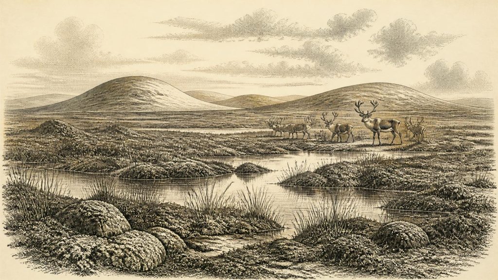
The Derryvree biological evidence gives this cold landscape texture. Pollen was poorly preserved, but plant macrofossils, mosses and insect remains indicate open tundra or muskeg-like wetland rather than forest. Sedges, arctic-alpine plants and aquatic species occurred around shallow freshwater, while fossil records of bogbean and alternate water-milfoil point specifically to vegetated pools or margins. The ground may have been seasonally waterlogged above frozen subsoil, with sparse dry-ground vegetation beyond it. Such a setting could appear bleak in winter yet be biologically productive during the brief growing season.
That reconstruction is evidence-based, but its limits matter. Fossil plants tell us that suitable habitats existed near the accumulating sediment; they do not yield an exact temperature, annual rainfall total or a complete map of Fermanagh. Nor should a single freshwater basin stand for the whole island. Greenagho, also in County Fermanagh, preserves older organic material beneath till, calibrated broadly to c. 37,200–35,700 years before present. Hollymount near Maguiresbridge and Aghnadarragh in County Antrim preserve further inter-till sequences. Together, these sites show that northern Ireland contained repeated, localised windows of non-glacial deposition amid a far longer history of advancing and retreating ice.
At the scale of north-west Europe, abrupt swings in North Atlantic climate were characteristic of Marine Isotope Stage 3. Greenland ice-core records document rapid shifts between colder stadials and milder interstadials. It is tempting to attach every Irish layer to one such named oscillation, but the correlation is not exact enough to turn an Irish deposit into a yearly chronicle. The sound conclusion is more modest: the Derryvree landscape belonged to an unstable cold-world system, and later growth of the Irish Ice Sheet would eventually overwhelm and preserve parts of it beneath glacial sediment.
Animals in the Irish Record
Caves in the limestone country of north County Cork supply a different kind of testimony. Castlepook Cave, also known as Mammoth Cave, near Doneraile has yielded remains attributed to a rich Late Pleistocene fauna, including woolly mammoth, reindeer, brown bear, wolf, fox, hare and spotted hyaena. These animals should not be imagined as all living side by side at the exact moment represented by 31,445 BCE. Cave deposits and historic museum collections commonly contain material accumulated in different episodes, and some early excavations disturbed the original layers. Direct dating has shown that individual bones can be far older or younger than formerly supposed.
Even with that warning, the faunal record is important. Reindeer and hare are consistent with extensive open country and cold conditions; mammoth and hyaena belong to a strikingly unfamiliar Irish ecosystem. Predators and scavengers may have dragged carcass parts into caves, while natural deaths, water movement and later excavation all influenced what survived. A bone in a cave is therefore evidence that an animal was present, not necessarily that the cave was its den, or that every listed species belonged to one food web. The Irish Quaternary Fauna Project remains fundamental because it directly dated specimens and demonstrated both the depth and the complexity of this record.
Low global sea levels exposed broad continental shelves, altering the shape of coasts and reducing some sea crossings. Yet the routes by which particular animals reached the lands now called Ireland remain uncertain and probably changed over time. A fossil animal establishes movement or survival at some point; it does not demonstrate a permanent land bridge, a single migration route or a humanly managed herd. The same restraint is needed when discussing the relationship between Ireland, Britain and continental Europe.
The Human Question
There is no securely demonstrated settlement, dwelling, hearth, grave, human skeleton or stone-tool assemblage in Ireland that can be assigned to this horizon. Consequently there is no responsible basis for describing a named people, language, kin group or territory in 31,445 BCE. ‘Ireland’, ‘Fermanagh’ and ‘Cork’ are modern place-names used to locate evidence, not evidence for an Irish identity or a political community. No archaeology from this date supports claims about leaders, laws, diplomacy, organised warfare or borders.
One discovery nevertheless makes the question of human presence worth keeping open. A reindeer femur from Castlepook’s historic collections has been reported as bearing a deep mark possibly made during fresh-bone butchery with a stone tool, alongside an early radiocarbon age for the animal. If both the dating and the human origin of the mark are sustained, it could represent an exceptionally early Upper Palaeolithic visit to Ireland. It would indicate an episode of animal processing, not a settled community, a population size, or continuous occupation. Current Castlepook research is deliberately seeking stratified deposits, securely associated tools, hearths or further modified bones because those are needed to test the claim properly.
This distinction between evidence and interpretation is especially important. Upper Palaeolithic groups elsewhere in Europe possessed sophisticated technologies, social networks, artistic traditions and knowledge of seasonal animal movement. Those wider comparisons show what was possible; they cannot fill the Irish silence with assumed tents, rituals or trading parties. Ireland has yielded no artefact or burial from around 31,445 BCE from which religion, learning, clothing, family structure or exchange can be directly recovered.
Society, Economy and What Cannot Be Known
If people briefly reached this landscape, acquiring food from large animals would have been a practical concern, and reindeer in particular could potentially supply meat, marrow, hide, sinew, bone and antler. That is a general archaeological inference, not a documented Irish economy. The Castlepook evidence cannot tell us whether one animal was hunted, scavenged or encountered already dead, what portions were removed, or whether any people travelled onward. It does not demonstrate trade, repeated seasonal rounds or a settlement network.
There is firmer negative evidence for many familiar historical themes. Agriculture was many millennia in the future; there were no farms, domesticated herds, cereal fields, pottery or built monuments known from Ireland. No Irish religious site, symbolic object, burial rite, written tradition or art can be connected to this date. Politics and diplomacy require enduring communities and institutions that have left no trace here. The most meaningful history is instead environmental: freshwater persisting between glacial advances, cold-adapted vegetation, animal movement through open terrain, and a landscape repeatedly made and unmade by ice.
Thus 31,445 BCE should be treated not as an Irish ‘year’ with an event to commemorate, but as a point within a calibrated archaeological interval. Derryvree, Hollymount, Greenagho, Aghnadarragh and Castlepook preserve fragments of that interval in different forms. Their combined lesson is powerful precisely because it is cautious: parts of Ireland supported life during a severe and volatile phase of the last Ice Age, while the evidence for people remains intriguing but unconfirmed. The later ice sheet both transformed this world and ensured that only rare buried archives now allow it to be glimpsed.
Primary Sources
- Palaeoecology
- Figure 6.— The subdivision of the Quaternary Period in Ireland
- Early Midlandian–Middle Midlandian, Pleistocene, Northern Ireland
- Introduction to the glacial Sand and Gravel Landscapes of Northern Ireland
- Aghnadarragh
- Trimlines, blockfields and the vertical extent of the last ice sheet in southern Ireland
- Growth and retreat of the last British–Irish Ice Sheet, 31,000 to 15,000 years ago: the BRITICE-CHRONO reconstruction
- Timing and pace of ice-sheet withdrawal across the marine–terrestrial transition west of Ireland during the last glaciation
- Freshwater organic deposits and stratified sediments between Early and Late Midlandian (Devensian) till sheets, at Aghnadarragh, County Antrim, Northern Ireland
- The Irish Quaternary Fauna Project
- A reconsideration of the radiocarbon dating of the Marine Isotope Stage 3 fauna from southern Ireland
- Archaeology Research Excavation Grant 2022: Castlepook Caves Project Final Report
- Archaeology Research Excavation Grant Report: Castlepook Cave
- 2022:564 – Castlepook Cave, Castlepook South, Cork
- New insights on the fauna of Ireland's Younger Dryas and Early Holocene from Alice & Gwendoline Cave
- Our Ancient Landscapes: Hunter-Gatherers in Ireland
- Archaeological Heritage of County Cork
- Ireland's Palaeolithic Archaeology – Fleeting Footprints in a Frozen Land
- The IntCal20 Northern Hemisphere radiocarbon age calibration curve (0–55 kcal BP)
- The IntCal20 Approach to Radiocarbon Calibration Curve Construction: A New Methodology Using Bayesian Splines and Errors-in-Variables
- Menyanthes trifoliata
- Myriophyllum alterniflorum
