

Derryvree’s Full-Glacial Waters31333 BCE
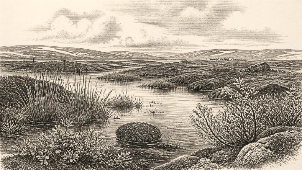
Labelled 31,333 BCE, this period in Ireland can only be placed broadly within Late Pleistocene Marine Isotope Stage 3. Derryvree, County Fermanagh, preserves freshwater silts between glacial tills, dated broadly to 36,900–31,700 calibrated years BP. They indicate locally ice-free, periglacial wetlands with mosses, sedges, aquatic plants, dwarf willow and open tundra, not woodland. Cave assemblages, especially Castlepook in Cork, document varied cold-stage fauna, including reindeer, mammoth, predators and scavengers, though not as a single contemporary community. A possibly butchered reindeer bone suggests Ireland’s earliest human activity, but proves neither settlement nor society. Environmental instability preceded expanding ice-sheet cover across Ireland.
Dateline
31,333 BCE is a modern chronological label, not a year anyone in Ice Age Ireland could have named or recorded. No written sources, calendar, ruler, settlement sequence or historical event permits year-by-year precision at this depth of time. A backwards conversion places the label roughly 33,282 years before the 1950 radiocarbon reference point, but that arithmetic is not itself an archaeological date. The responsible approach is to place it within the Late Pleistocene, during Marine Isotope Stage 3, and to use broad, calibrated ranges rather than pretend certainty.
The most informative Irish evidence close to this notional year comes not from a village or grave, but from a buried wetland at Derryvree near Maguiresbridge, County Fermanagh. Its organic silts and fine sands were found between two layers of glacial till when road works cut through a drumlin in 1969. The dated deposit produced the radiocarbon determination BIRM-166, 30,500 radiocarbon years BP, with a substantial uncertainty. Later calibration places it broadly at about 36,900–31,700 calibrated years BP. That span includes 31,333 BCE, but it cannot identify conditions, plants or animals in that precise calendar year.
A Wetland Between Ice Advances
Derryvree preserves an interval when ice was not overriding this part of Fermanagh. The lower and upper tills document glacial activity before and after the freshwater deposits; the silts in between preserve a local landscape with standing or slowly moving water, saturated ground and open country. This is the clearest direct environmental testimony for Ireland around the early thirties of millennia BCE. It also offers a warning against imagining a uniform island. Conditions changed sharply through time and varied by region: a place could be ice-free, tundra-like and wet while ice masses expanded elsewhere or were poised to return.
The evidence points to a periglacial climate: severe cold, frequent freezing and thawing, and ground conditions unlike those of modern temperate Ireland. Pollen was poorly preserved, but it was chiefly from herbaceous plants rather than woodland. Plant macrofossils and pollen indicate mosses, sedges and cold-adapted vegetation. Fossil records from the deposit include bogbean, an aquatic plant of shallow freshwater margins, as well as alternate water-milfoil and dwarf willow. Such finds make the scene more complex than an empty frozen plain. There were pools and wet hollows, vegetation at their edges, and sparse dry-ground plant cover beyond them.
Woodland should not be projected into this setting. A few grains attributed to trees may have travelled long distances or been redeposited; they do not demonstrate a local forest. The strongest interpretation is an open tundra or muskeg-like mosaic, in which low plants could exploit the short growing season. Water was central to the landscape. It collected in depressions, supported aquatic plants and insects, and formed a refuge from the wind in a terrain otherwise exposed to a cold continental climate. The Derryvree record is therefore evidence for ecological persistence under harsh conditions, not evidence for a familiar Irish countryside.
Animals in an Open Country
The animal world is illuminated mainly by caves in Munster, especially Castlepook Cave near Doneraile in north County Cork. The cave has produced one of Ireland’s richest Pleistocene faunal collections. Direct radiocarbon dating carried out through the Irish Quaternary Fauna Project showed that different bones belong to widely separated episodes before the Last Glacial Maximum. Reindeer, brown bear, giant deer, woolly mammoth, wolf, Arctic fox, lemmings and spotted hyaena are among the animals represented in the wider assemblage.
These names should not be turned into a single herd crossing a single landscape in 31,333 BCE. Cave deposits accumulated over long periods; carnivores, water movement, natural deaths and early excavation all helped mix their contents. Individual radiocarbon determinations provide dates for particular bones, not a complete census of animals living together. Even so, the assemblage securely establishes that Ireland supported a much richer cold-stage fauna at various times between at least about 45,000 and 20,000 years ago than its later historic fauna would suggest.
Reindeer and mammoth are especially useful indicators of extensive open habitats, while hyaena and wolf remind us that large predators and scavengers were active. Cave entrances and fissures could attract animals seeking shelter, trap carcasses or become places where predators carried prey. The Castlepook bones therefore document both living creatures and the processes that formed the archive. A hyaena bone says that hyaenas reached the region; it does not prove that a hyaena den stood in the cave during the same season as every other fossil.
The Human Question
A reindeer femur from Castlepook has transformed discussion of Ireland’s deepest human past. Publicly reported research identifies a mark on the bone as consistent with cutting or butchery by a stone tool, and dates the specimen to roughly 33,000 years ago. If that interpretation is sustained, it is the earliest evidence for human activity in Ireland by a very large margin. It would show that people handled the carcass of a reindeer during the Late Pleistocene, at a time long before the well-attested Mesolithic settlement of the island after the final retreat of the ice.
Its importance is matched by its limitations. The bone was recovered from an old cave collection, not from a modern, undisturbed excavation with associated hearths, stone tools and occupation surfaces. The age dates the animal bone; the identification of the incision as a human-made cut is a separate zooarchaeological judgement. No human bones, built shelters, hearth, diagnostic lithic assemblage or repeated activity area has yet been demonstrated for Ireland at this date. Nor is there evidence to attach any possible visitors to a particular continental archaeological tradition such as the Aurignacian or Gravettian.
The most that can responsibly be inferred is modest but significant: a brief visit by one or more mobile people remains possible, and the exploitation of a large animal is conceivable if the cut mark is anthropogenic. It does not establish permanent occupation, a resident population or a hunting camp at Castlepook. Equally, the absence of sites cannot prove that no people came. Later ice action, erosion, sea-level change and the rarity of carefully excavated Pleistocene deposits have all made evidence exceptionally difficult to preserve and recognise.
Society Beyond Recovery
There is no basis for describing political affairs, leaders, territories, diplomacy, warfare, religious observance or named communities in Ireland around this date. There were no states, written agreements or institutions visible in the record. If people did reach the island, they were almost certainly small, mobile hunter-gatherer parties rather than a population capable of leaving the dense archaeological signatures of later farmers. But even that is an inference from the possible reindeer butchery evidence and from wider European comparison, not a documented Irish social order.
For the same reason, trade cannot be demonstrated. Lower global sea levels altered the outlines of the surrounding seas, yet the exact routes available to people and animals at any one moment remain uncertain. Ireland’s relationship to Britain and the European mainland must not be simplified into an assured land bridge. There is no Irish evidence at 31,333 BCE for exchange networks, imported materials, boats or repeated crossings. The cave bone, if humanly modified, indicates contact with a carcass, not commerce.
Culture and learning are similarly beyond direct recovery. A group capable of using a sharp stone edge would have possessed practical knowledge of animal bodies, cutting and survival in a cold environment. It may also have carried stories, social rules and beliefs, as all human groups do. Yet Derryvree’s seeds and Castlepook’s bones cannot tell us their language, kinship, music, art or religion. To fill that silence with Celtic, Gaelic or later Irish identities would be an anachronism of more than thirty millennia.
Approaching the Ice Maximum
The larger development was environmental instability. The interval belongs to a long transition before the Last Glacial Maximum, when the British–Irish Ice Sheet eventually grew to cover most of Ireland and adjacent shelves. Modern reconstructions show that its growth and maximum were asynchronous across regions, rather than one simple advance across the entire island. At Derryvree, the freshwater deposits demonstrate that north-central Ireland was locally ice-free during part of a broad pre-maximum interval; the enclosing tills show how precarious that condition was.
For people, if present, such change would have shaped every decision: where animals could graze, when water froze, which caves remained accessible and whether a journey could be supplied. For plants and animals, it determined survival corridors and local extinction. The enduring historical value of 31,333 BCE lies not in a falsely precise event but in this conjunction of evidence: a Fermanagh wetland thriving under periglacial conditions, a varied fauna documented in southern caves, and a tantalising reindeer bone that may record Ireland’s earliest known human action. It is a landscape on the edge of a far greater freeze, recovered from sediments, fossils and carefully qualified interpretation.
Primary Sources
- Palaeoecology
- Figure 6.— The subdivision of the Quaternary Period in Ireland
- The Irish Quaternary Fauna Project
- Growth and retreat of the last British–Irish Ice Sheet, 31,000 to 15,000 years ago: the BRITICE-CHRONO reconstruction
- Trimlines, blockfields and the vertical extent of the last ice sheet in southern Ireland
- The deglaciation of the western sector of the Irish Ice Sheet from the inner continental shelf to its terrestrial margin
- Timing and pace of ice-sheet withdrawal across the marine–terrestrial transition west of Ireland during the last glaciation
- Stratigraphic and palaeo-geomorphological evidence for the glacial-deglacial history of the last British-Irish Ice Sheet in the north-western Irish Sea
- Deglaciation chronology of the Donegal Ice Centre, north-west Ireland
- Dimensions and chronology of the last ice sheet in Western Ireland
- Maximum extent and dynamic behaviour of the last British–Irish Ice Sheet west of Ireland
- The IntCal20 Northern Hemisphere radiocarbon age calibration curve (0–55 cal kBP)
- A Middle Midlandian freshwater series at Derryvree, Maguiresbridge, County Fermanagh, Northern Ireland
- BSBI: Menyanthes trifoliata
- BSBI: Salix herbacea
- BSBI: Myriophyllum alterniflorum
- Archaeology Research Excavation Grant 2022
- 2022:564 – Castlepook Cave, Castlepook South, Cork
- Heritage Artefacts of County Cork
- Archaeological Heritage of County Cork
- Our Ancient Landscapes: Hunter-Gatherers in Ireland
- New insights on the fauna of Ireland's Younger Dryas and Early Holocene from Alice & Gwendoline Cave



