

Fermanagh’s Bogbean Interval31106 BCE
At 31,106 BCE, a modern label within a broad radiocarbon range, Ireland experienced unstable late Marine Isotope Stage 3 conditions. Derryvree, County Fermanagh, preserves freshwater sediments between glacial tills, indicating an ice-free, treeless periglacial wetland of mosses, sedges, bogbean and tundra plants before later ice advance. Although ice sheets were expanding, glaciation remained uneven and sea-level change did not necessarily create accessible routes. Cave finds suggest cold-adapted mammals, including reindeer, mammoth and predators, but are time-averaged and fragmentary. Possible early human modification of a Castlepook bone remains unconfirmed; secure human evidence is far later. This is primarily regional environmental history.
Dateline
A Date Inside a Range
“31,106 BCE” is a modern chronological label, not a date that anyone in prehistoric Ireland could have known or recorded. There was no writing, calendar, named community or archaeological sequence capable of identifying one particular year. In radiocarbon terms the label falls approximately 33,000 calendar years before AD 1950, the conventional scientific “present”; but that conversion should not imply annual precision. The most useful Irish evidence belongs to broader calibrated ranges. Around this point, Ireland lay in the later part of Marine Isotope Stage 3, a long and climatically unstable phase before the Last Glacial Maximum. The closest well-dated Irish environmental archive is the Derryvree deposit near Maguiresbridge, County Fermanagh: organic freshwater sediments whose published radiocarbon result calibrates broadly to about 36,900–31,700 cal BP. The date in question sits within that wide interval, not at a pinpoint in its layers.
Derryvree matters because the deposit was found sealed between two substantial sheets of glacial till in a drumlin exposed by road works in 1969. Such preservation is exceptional. Later ice movement scoured, mixed, buried or removed much of Ireland’s older surface evidence, leaving few archives from this period. The silts and fine sands at Derryvree therefore do not tell us what happened in one named year. They preserve a compressed environmental record of a period in which fresh water, plants, insects and sediment accumulated before renewed glaciation covered the site. It is an archive of conditions and ecological possibility rather than a narrative of events.
A Wetland Between Glaciations
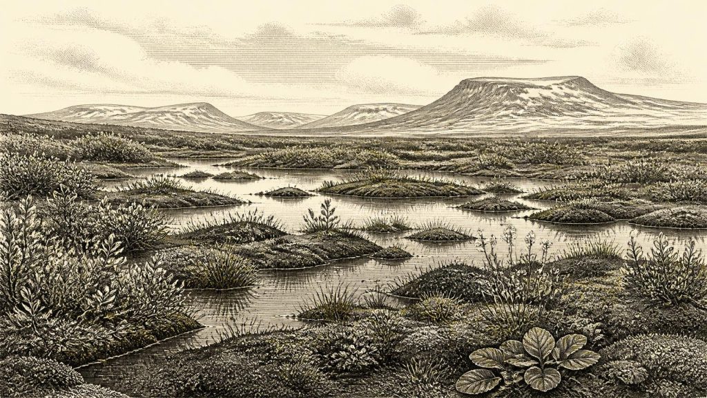
The Derryvree fossils point to a treeless, periglacial wetland: a mosaic of saturated ground, mosses, sedges, shallow pools and low tundra vegetation. The published plant evidence includes grasses and sedges, juniper and herbaceous plants, with mosses especially prominent. Bogbean (Menyanthes trifoliata), an aquatic or marsh plant still found in suitable Irish wetlands, is among the evocative survivors. Other indicators associated with the deposit include dwarf willow, mountain-avens, Arctic-alpine clubmoss and water-milfoil. Together they rule out the familiar wooded Ireland of later prehistory. They instead suggest open ground with short growing seasons, cold winters and waterlogged hollows.
“Muskeg” is sometimes used for this environment: not a perfect modern equivalent, but a useful shorthand for peat-forming, moss-rich, wet ground broken by open water. Insect remains support this picture of pools rich in plant matter amid cold-climate vegetation. The evidence is local, however. It should not be expanded uncritically into a uniform map of the island. A roadside exposure in Fermanagh records one lowland basin and its catchment, not every coast, mountain or valley. Yet it securely shows that, within a broader cold phase, at least part of Ireland supported a living freshwater ecosystem rather than lying continuously beneath ice.
The climate was severe but not static. Ireland’s position beside the North Atlantic made it responsive to abrupt last-glacial shifts. Speleothems in Crag Cave, County Kerry, provide an independent kind of evidence: calcite could grow only when liquid water entered the cave and temperatures were sufficiently mild to permit it. Uranium-thorium dates show episodic growth during Marine Isotope Stage 3, consistent with repeated ameliorations and deteriorations rather than a single, uninterrupted freeze. This does not mean Derryvree was warm. It means that “Ice Age” conditions contained rapid environmental pulses, in which ground water, vegetation and animal ranges could change over timescales far shorter than archaeological period labels suggest.
Ice Was Building, Not Yet at Its Maximum
At around 31,106 BCE, the Last Glacial Maximum still lay ahead. Older reconstructions conventionally placed the main build-up of the British–Irish Ice Sheet after roughly 35–32 ka, with its maximum extent later, broadly during 27–21 ka. More recent BRITICE-CHRONO work likewise portrays a dynamic, unevenly advancing ice sheet rather than an island covered everywhere at once. Its 31 ka reconstruction models a large ice cap over north-western Ireland, spanning the Derryveagh and Sperrin Mountains, and smaller ice fields or glaciers in several upland districts, including the Dartry Mountains, Wicklows, Mournes and south-western ranges. Models are valuable syntheses of field evidence and ice physics, but they remain reconstructions rather than direct photographs of the landscape.
This setting gives Derryvree its particular force. The organic layer proves an ice-free phase at the locality before it was overridden by the younger till, while the wider island was entering a period of increasing glaciation. The wetland may have been close to active ice or to landscapes shaped by older ice, but its sediments do not allow a precise distance from a glacier margin to be calculated. Nor can they establish the length of every season. What they do demonstrate is regional change: water collected in a low basin; tundra plants colonised its edges; organic matter survived long enough to form a recognisable deposit; and a later advance sealed this evidence below the drumlin.
Sea level was lower than today as global ice sheets grew, exposing parts of the continental shelf around north-west Europe. That fact should not be turned into a simple picture of a dry, easy land bridge to Ireland. The configuration of land, sea, ice and coasts changed through time, while northern routes were complicated by ice masses and marine inlets. For people or animals, any crossing would have depended on particular routes and seasons that Irish evidence cannot reconstruct for this date. The island’s apparent accessibility is therefore an open palaeogeographical question, not proof of migration.
Animals and the Limits of the Cave Record
Irish cave collections nevertheless show that substantial mammals occupied, or at least reached, the island during broad parts of this pre-maximum interval. The Irish Quaternary Fauna Project dated material from caves including Castlepook in north Cork. Its results demonstrate a varied Late Pleistocene fauna over tens of millennia: reindeer, giant deer, brown bear, wolf, Arctic fox, lemmings, spotted hyaena and woolly mammoth occur among the dated cave assemblages. At Castlepook, particular reindeer, mammoth and giant-deer specimens produced conventional radiocarbon ages in the broad 32,000–39,000 BP range. These finds make an open, cold-country fauna plausible for Ireland during Marine Isotope Stage 3.
But the cave evidence has a crucial limitation. A cave is not a census of a single living landscape. Bones can have been carried in by carnivores, water or people; animals from different episodes can be mixed; and many of the key specimens were recovered in early excavations, before modern standards of stratigraphic recording. A mammoth rib, hyaena bone and reindeer limb from one cave do not prove that those animals stood together on one day, still less in 31,106 BCE. The responsible conclusion is broader: Ireland contained, at different points in the period, habitats capable of supporting large herbivores and formidable carnivores, but its surviving faunal record is fragmentary and time-averaged.
The Human Question
The same caution is even more important for people. A reindeer femur from Castlepook Cave has been publicised as approximately 33,000 years old and as bearing a deep mark interpreted as a stone-tool cut or chop made while a carcass was processed. If future study confirms both the taphonomic interpretation and its dating context, the specimen could be evidence of a very early Upper Palaeolithic visit to Ireland. It would be historically important precisely because it is so rare. Yet it came from an old cave collection, not from a modern excavation of an intact occupation floor, and no securely associated hearth, stone-tool assemblage, dwelling, human remains or repeated activity area of comparable age has been identified. The bone’s age dates the animal, not automatically the moment of marking, the place of death or the duration of any human presence. It cannot demonstrate a settled population.
The earliest firmly published evidence for human activity in Ireland remains much later: cut marks on a brown-bear kneecap from Alice and Gwendoline Cave, County Clare, directly dated to about 12,810–12,590 cal BP. That contrast is instructive. It is reasonable to treat a possible Castlepook trace as an important research question for the earlier period, but not as permission to invent a 31st-millennium BCE camp, hunting party or migration. The archaeological silence may reflect genuine absence, brief visits that left little trace, loss of sites to ice and sea, or all three.
No Polities, but a Changing World
There is no evidence for political institutions, leaders, territories, warfare, diplomacy, trade networks, formal religion, art or learning in Ireland at this date. Such categories depend on records that do not survive here, and it would be misleading to borrow the richer Upper Palaeolithic societies of continental Europe and install them in Fermanagh or Cork. If people did enter Ireland, the most that can be said is that they may have been highly mobile foragers able to use cutting tools and exploit animal resources. Whether they hunted, scavenged, travelled by water, followed herds, exchanged knowledge, or returned repeatedly is unknown.
Everyday life is better approached through ecology than through imagined households. Any human visitor would have faced exposed terrain, sharply seasonal resources, wet ground and an unpredictable climate; reindeer and other large mammals would have offered food, hide, bone, sinew and fuel potential, but none of those uses is directly attested at Derryvree. The principal story around 31,106 BCE is consequently environmental and regional: an Irish landscape of ice fields and ice-free refuges, low wetlands and open tundra, inhabited by cold-adapted plants and, at times, large mammals. Derryvree’s buried bogbean seed and mossy sediments are modest remains, but they provide more reliable history than a detailed tale of people for whom Ireland has not yet yielded a secure home.
Primary Sources
- A Middle Midlandian Freshwater Series at Derryvree, Maguiresbridge, County Fermanagh, Northern Ireland
- Middle Midlandian Interstadial Deposits at Greenagho, Near Belcoo, County Fermanagh, Northern Ireland
- The Subdivision of the Quaternary Period in Ireland
- Landscapes and Environments of the Last Glacial-Interglacial Transition: A Time of Amazingly Rapid Change in Ireland
- Episodic Speleothem Deposition Tracks the Terrestrial Impact of Millennial-Scale Last Glacial Climate Variability in SW Ireland
- The Irish Quaternary Fauna Project
- Growth and Retreat of the Last British–Irish Ice Sheet, 31,000 to 15,000 Years Ago: The BRITICE-CHRONO Reconstruction
- Growth and Retreat of the Last British–Irish Ice Sheet, 31,000 to 15,000 Years Ago: The BRITICE-CHRONO Reconstruction
- Extent and Timing of the Last Glacial Maximum in Britain and Ireland: A Review
- Trimlines, Blockfields and the Vertical Extent of the Last Ice Sheet in Southern Ireland
- Exploring the Dynamics of the Donegal Bay and Malin Sea Ice Streams of the British-Irish Ice Sheet During the Last Glacial Cycle
- The IntCal20 Northern Hemisphere Radiocarbon Age Calibration Curve (0–55 cal kBP)
- The Problem of a Late Quaternary Landbridge Between Britain and Ireland
- Deglaciation, Earth Crustal Behaviour and Sea-Level Changes in the Determination of Insularity: A Perspective from Ireland
- First Evidence of a Late Upper Palaeolithic Human Presence in Ireland
- New Insights on the Fauna of Ireland's Younger Dryas and Early Holocene from Alice & Gwendoline Cave
- Archaeology Research Excavation Grant 2022: Final Report
- 32564: Castlepook Cave, Castlepook, County Cork
- Heritage Artefacts of County Cork
- The History of Red Deer in Ireland: A Genetic Perspective
- The Exploration of the Caves of County Clare: Geology
- BSBI: Menyanthes trifoliata