
Maguirebridge’s Arctic Herbarium30506 BCE
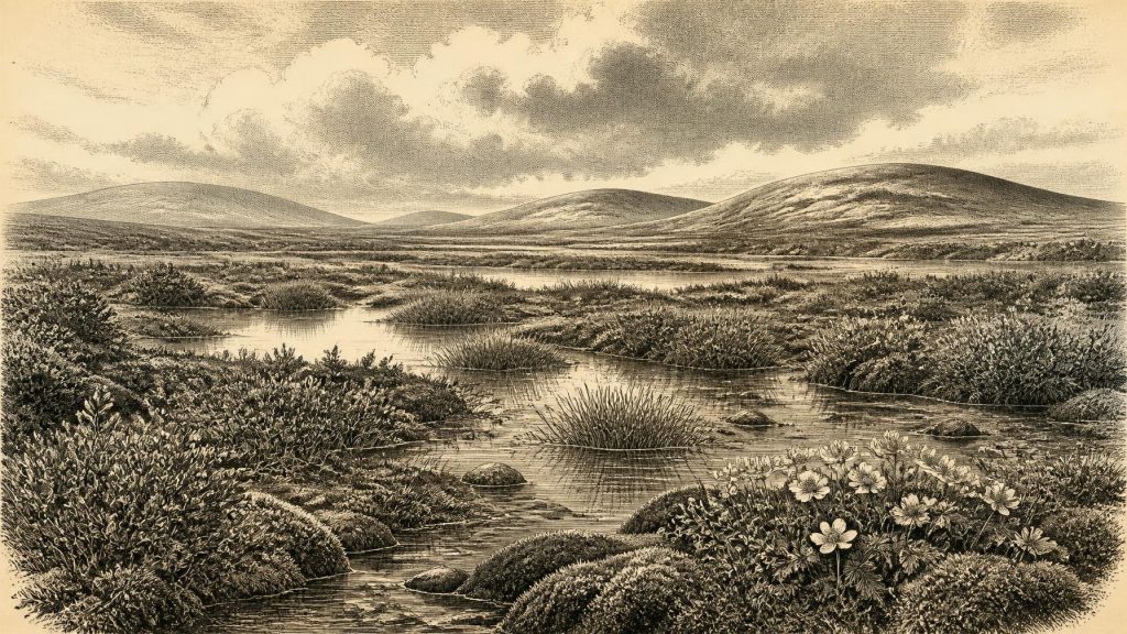
Around 30,506 BCE, Ireland experienced unstable Late Pleistocene conditions rather than a datable historical year. At Derryvree near Maguiresbridge, Fermanagh, freshwater silts between glacial tills record an ice-free interval before renewed glaciation. Pollen, seeds, mosses and beetles reveal treeless tundra with sedges, dwarf willow, mountain avens, bogbean, pools and wet ground, supporting seasonal life despite severe winters. Castlepook Cave in Cork preserves remains of mammoth, reindeer, giant deer, hyaena and other cold-adapted animals. A possibly butchered reindeer bone may indicate an early human visit, but cannot prove settlement. These fragmentary deposits demonstrate changing environments, not continuous occupation or precise events.
Dateline
30,506 BCE cannot be treated as a date in the modern historical sense. No written record, settlement sequence or calendar capable of identifying a particular Irish year exists at this depth of time. The number is best used as a point within a much broader Late Pleistocene horizon. Around it, Ireland lay in the Middle Midlandian, part of the last glacial cycle, during a period of sharp climatic instability before the Last Glacial Maximum. The most illuminating Irish evidence is not an event or a person, but a buried freshwater deposit at Derryvree near Maguiresbridge, County Fermanagh: a small archive of plants, insects and sediments sealed between two layers of glacial till.
A Date Within a Range
The crucial Derryvree sample, laboratory number Birm-166, produced a conventional radiocarbon result of 30,500 years before present, with a substantial uncertainty of minus 1,030 and plus 1,170 years. “Before present” conventionally means before 1950, and a radiocarbon age is not a calendar date. Changes in atmospheric carbon-14 mean that such determinations must be calibrated. Later scholarship places the Derryvree organic silts broadly at about 36,900–31,700 calibrated years before present, approximately 34,950–29,750 BCE. Thus 30,506 BCE falls within the wide chronological range that this deposit can responsibly illuminate; it is emphatically not the year in which the mud accumulated, a seed fell, or an animal visited the water’s edge.
That distinction matters. A layer of sediment is accumulated over time, and its fossils may have been transported, redeposited or preserved from slightly different moments. Nor does one site stand for the whole island. Derryvree provides unusually direct evidence that its corner of Fermanagh was ice-free during an interval between glacial advances. It does not prove that every region of Ireland shared precisely the same climate, vegetation or ice cover at the same instant. The appropriate history of 30,506 BCE is therefore a history of ranges, sequences and likelihoods rather than anniversary-like certainty.
Freshwater Between Two Glaciers
Road works in 1969 cut through a drumlin at Derryvree, about two kilometres north-east of Maguiresbridge. The exposure revealed a striking order of deposits. A lower till, material laid down directly by glacier ice, was overlain by fine sands, silts and organic layers formed in freshwater conditions. Above these lay a second thick till. The sequence records three broad chapters: ice had occupied the locality; water, vegetation and invertebrate life then developed in an ice-free interval; and a later ice advance buried the evidence beneath fresh glacial debris.
The middle deposit was no lush woodland soil. Its pollen, plant macrofossils, mosses and beetle remains describe open tundra and a periglacial regime: ground and waters shaped by severe cold, frost action and seasonal thaw close to, but not necessarily beneath, active glacier ice. Grasses and sedges were prominent. Fossils of dwarf willow, mountain avens and bogbean, together with mosses and aquatic plants including water-milfoil, indicate a patchwork rather than a uniform waste. Shallow pools, wet mossy ground, sedge margins and more exposed herb-rich surfaces could coexist across a landscape largely without trees.
“Arctic” should not be imagined as an uninterrupted white desert. The Derryvree evidence instead suggests a short summer growing season in which plants flowered, insects reproduced and freshwater habitats supported life. Bogbean is especially evocative: its three-part leaves and white flowers are now familiar plants of wet ground, but its fossil seed at Derryvree testifies to a hardy wetland flora living under conditions much colder than those of modern Fermanagh. Winter, however, would have been long and harsh. The insects and plants together support an interpretation of exposed ground, pronounced seasonality and cold pools rich in decaying vegetation.
An Island Being Remade
At this stage Ireland’s outlines, shorelines and connections to neighbouring lands cannot simply be projected from a modern map. Global sea level was lower during the glacial period because much water was stored in ice sheets. More of the continental shelf was exposed, while ice, rivers, lakes and changing sea levels repeatedly altered routes across the Irish Sea region. Yet the exact local geography relevant to a particular visit or animal movement remains uncertain. It would be careless to state that a fixed land bridge existed at 30,506 BCE, or that travellers could certainly walk from a particular Irish coast to Britain.
What can be said is that Ireland was part of a wider north-west European environmental zone, not an isolated ecological world. The Derryvree deposit predates the fullest expansion of the last British-Irish Ice Sheet. Later ice growth profoundly remodelled the island, scouring some landscapes, depositing till and burying or destroying much older evidence. This later glaciation helps explain why the Irish Palaeolithic record is so thin. Campsites on exposed ground were especially vulnerable to erosion and ice action; cave and inter-till deposits had better chances of survival, but even they are fragmentary and difficult to date precisely.
Animals in the Cold Landscape
Fermanagh’s freshwater fossils do not provide a large mammal census. For that, the principal Irish archive is Castlepook Cave, also called Mammoth Cave, near Doneraile in north County Cork. Its cave deposits have yielded remains of woolly mammoth, reindeer, giant deer, spotted hyaena, brown bear, wolf, foxes, hare and lemmings. These bones were not all deposited together, nor should the cave fauna be treated as a photograph of one day or one valley. Carnivores carried material into caves; water and natural deaths also shaped deposits; and early excavations removed much stratigraphic context. Nonetheless, the assemblage demonstrates that cold-adapted mammals repeatedly reached Ireland during parts of the Late Pleistocene.
Some Castlepook specimens have radiocarbon dates in the broad range relevant to the Derryvree cold phase, including mammoth and spotted hyaena remains. The combination of large grazers, browsers, scavengers and predators is consistent with open habitats capable of sustaining mobile herds and their hunters. Reindeer in particular fit a landscape of tundra, sedges, herbs and seasonal movement. Mammoths and giant deer are more striking to modern eyes, but their bones should not lead to visions of dense, permanent populations. The Irish record documents presence over long intervals, not herd sizes or annual migrations.
People: A Possibility, Not a Polity
There were no Irish kingdoms, borders, treaties, chiefs, farms, villages or organised political institutions that can be identified for this time. Nor is there evidence from Ireland for ritual sites, burials, art, language, formal learning or trade networks around 30,506 BCE. It is possible to describe how Upper Palaeolithic hunter-gatherers elsewhere in north-west Europe lived by hunting, gathering plant foods, making stone tools, maintaining social ties and moving across large territories. It is not legitimate to convert that continental evidence into a detailed account of an Irish community.
The nearest possible human clue is a reindeer femur from Castlepook Cave bearing a deep linear mark that has been interpreted as damage from a stone implement used on fresh bone. If that interpretation is sustained, it indicates that people handled or butchered a reindeer in Ireland roughly 33,000 years ago, far earlier than the island’s formerly accepted human record. It would be an important sign of a brief Palaeolithic visit or visits. But the bone is not a house floor, hearth, tool kit or burial. Its date is the age of the animal bone, not necessarily the exact instant of marking, and its cave context has been disturbed by natural processes and historic excavation. It cannot establish continuous occupation, a named population or a settlement at Derryvree.
Accordingly, everyday life at the date can only be framed negatively and cautiously. If people did enter Ireland during this wider interval, they may have travelled in small, highly mobile groups and exploited meat, hides, bone and other materials from animals encountered in an open cold landscape. Such possibilities explain why a butchered limb would matter. They do not demonstrate a resident society, a permanent camp or routine exchange. The absence of securely dated tools and settlement traces is itself part of the evidence.
The Evidence’s Proper Scale
The great development illuminated by 30,506 BCE is environmental, not political: Ireland contained locally ice-free terrain during a severe, changing phase of the last glacial cycle. At Derryvree, freshwater accumulated among treeless tundra plants before glacier ice returned. At Castlepook, animal remains preserve evidence of a wider cold-climate fauna, and perhaps an exceptionally early human encounter. Together they show an Ireland that was neither timelessly frozen nor recognisably modern: a shifting mosaic of wet ground, open vegetation, animals and advancing ice.
The legacy is also methodological. Ireland’s deep past at this horizon survives in a seed, a pollen grain, a beetle fragment, a bone and the order of layers beneath a drumlin. These remain powerful witnesses precisely because they set limits on imagination. They permit a vivid picture of cold wetlands and Ice Age animals, while requiring honesty about all that cannot be recovered: the exact year, the people’s identities, and whether anyone was present in Ireland on this particular notional date.
Primary Sources
- Middle Midlandian Freshwater Series at Derryvree, Maguiresbridge, County Fermanagh, Northern Ireland
- Irish Pleistocene Biostratigraphy
- Trimlines, Blockfields and the Vertical Extent of the Last Ice Sheet in Southern Ireland
- Growth and Retreat of the Last British-Irish Ice Sheet, 31,000 to 15,000 Years Ago: the BRITICE-CHRONO Reconstruction
- Exploring Controls of the Early and Stepped Deglaciation on the Western Margin of the British-Irish Ice Sheet
- New Data for the Last Glacial Maximum in Great Britain and Ireland
- Late Pleistocene Chronostratigraphy and Ice Sheet Limits, Southern Ireland
- Ireland: Submerged Prehistoric Sites and Landscapes
- The Irish Quaternary Fauna Project
- Occurrence of Mammalia Relicts at Site Castlepook Cave
- Castlepook Cave, County Geological Site Report
- Archaeological Heritage of County Cork: Volume 1
- Areas of Scientific Interest in County Cork
- Prehistoric Details: Mell Flint Flake
- Ireland's Palaeolithic Archaeology – Fleeting Footprints in a Frozen Land
- New Insights on the Fauna of Ireland's Younger Dryas and Early Holocene from Alice & Gwendoline Cave
- Menyanthes trifoliata
- Salix herbacea
- Dryas octopetala
- Myriophyllum alterniflorum
- The IntCal20 Northern Hemisphere Radiocarbon Age Calibration Curve (0–55 cal kBP)
- Composition and Consequences of the IntCal20 Radiocarbon Calibration Curve