
Derryvree’s Bogbean Register30334 BCE
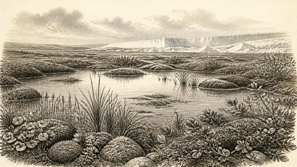
The label 30,334 BCE cannot identify an Irish event, but falls within a broad calibrated range for Late Pleistocene Marine Isotope Stage 3. At Derryvree, County Fermanagh, organic freshwater silts between glacial tills record an ice-free interval before renewed glaciation. Fossil plants and insects indicate a patchy, tundra-like periglacial wetland with sedges, mosses, bogbean and water-milfoil. Ireland’s ice sheet expanded unevenly, later reshaping landscapes and destroying evidence. Cave fauna demonstrate changing communities of large mammals and predators, not a single contemporary assemblage. No securely dated occupation establishes human presence, society or trade. The period is environmentally reconstructed from uncertain evidence.
Dateline
“30,334 BCE” is a useful modern label, not a recoverable year in Ireland’s past. No written calendar, annual archive or securely dated human occupation can identify an event, a community or even a season on the island at that precision. The evidence instead belongs to the Late Pleistocene, during Marine Isotope Stage 3: a cold and changeable interval before the Last Glacial Maximum. It consists chiefly of stratified glacial sediments, fossil plants and insects, cave bones, landforms and scientific dates with wide margins of uncertainty.
The closest Irish evidence is not a town, tool-kit or burial, but a buried wetland at Derryvree near Maguiresbridge, County Fermanagh. Its organic silts preserve a moment of ice-free freshwater conditions between two deposits of glacial till. They offer an unusually vivid but local glimpse of Ireland during the long approach to the maximum expansion of the British–Irish Ice Sheet. The correct history for this date is therefore one of environments, animal movement and advancing ice—not kings, wars or settled societies.
A Date Within a Range
The numbered year falls at roughly 32,283 calibrated years before present, where “present” in radiocarbon practice means AD 1950. That conversion is only a modern chronological convenience. Radiocarbon determinations are not calendar dates: changing atmospheric carbon-14 levels mean that measurements must be calibrated, and at this depth of time calibrated results commonly cover broad ranges rather than a single year.
Derryvree’s key sample, BIRM-166, was reported as 30,500 radiocarbon years before present, with a substantial uncertainty. Published calibration has placed it broadly between about 36,900 and 31,700 calibrated years before present—approximately 34,950 to 29,750 BCE. The nominal year 30,334 BCE lies within that wide interval, but cannot be tied to a particular plant, animal or episode in the deposit. The date tells us that organic material accumulated in the basin during a cold phase before later ice sealed it; it does not give a diary entry for Ireland.
This distinction matters because the country’s Pleistocene record has repeatedly been revised as methods improve. Old radiocarbon measurements can be affected by contamination, and cave deposits can combine bones accumulated at different times by carnivores, water and excavation. Modern calibration and re-dating refine the picture, but they do not create the annual precision that the evidence never possessed.
The Wetland Beneath the Drumlin
At Derryvree, roadworks exposed a striking sequence through a drumlin: glacial sediment below, fine sands and organic-rich freshwater silts in the middle, and further till above. The sequence provides firm evidence for three broad propositions. First, glacier ice had previously occupied the locality. Secondly, there was a later interval in which open water, wet ground and vegetation could develop. Thirdly, the place was overridden or buried by renewed glacial action. It is this physical order, rather than any one fossil, that makes the site so important.
The plant and insect evidence indicates open tundra-like country and a periglacial regime—ground subject to severe cold, seasonal freezing and thawing, near or beyond glacier margins. It was not a featureless white wilderness. The silts contain evidence of sedges, mosses and hardy herbs, while fossil remains of bogbean (Menyanthes trifoliata) and alternate water-milfoil (Myriophyllum alterniflorum) demonstrate freshwater and saturated margins. Dwarf willow, mountain avens and other cold-adapted plants point to low, sparse vegetation rather than woodland.
Such a setting would have been patchy. Shallow pools and mossy banks could sustain short bursts of summer growth; exposed ground, frost-shattered slopes and poorly drained hollows would have been much harsher. The evidence supports a living wetland within an open cold landscape, but it should not be expanded uncritically into a map of every Irish region. Derryvree records Fermanagh, not the whole island.
Ice Building Across Ireland
Ireland was not yet uniformly in the climatic condition associated with the later Last Glacial Maximum. Research on the British–Irish Ice Sheet places its broad build-up after about 35,000–32,000 years ago, with differing sectors reaching their greatest extent at different times. A major synthesis identifies maximum ice extent across the wider ice sheet between roughly 30,000 and 22,000 years ago, while older working models place the principal maximum around 27,000–21,000 years ago. These are overlapping reconstructions, not a single instant when all ice arrived together.
The Derryvree deposit is important precisely because it demonstrates ice-free conditions in north-central Ireland before a later advance. Other Fermanagh deposits and marine evidence from western Ireland reinforce the conclusion that the growth of the ice sheet was uneven and geographically complex. Ice sheets do not behave as simple climate maps. Their margins respond to snowfall, bedrock, sea level, topography and internal flow, so neighbouring districts may have experienced very different conditions over long spans.
By the later maximum, ice would reshape much of Ireland and its surrounding continental shelf, eroding older surface deposits and burying others. That destructive power helps explain why evidence for early landscapes and any fleeting human activity is so scarce. It also means that absence of a site is not proof that a landscape was biologically empty. It is, however, a reason to be cautious about claims that cannot be anchored in secure stratigraphy.
Animals in a Cold Mosaic
Southern Irish caves, especially Castlepook Cave near Doneraile in County Cork, preserve an extraordinary record of Ice Age fauna. The wider assemblage includes reindeer, woolly mammoth, giant deer, brown bear, wolf, Arctic fox, lemmings and spotted hyaena. These remains show that Ireland was, at various times during the broader Middle and Late Midlandian cold stages, accessible to substantial mammals and predators. They make it impossible to portray Pleistocene Ireland simply as an empty, permanently ice-covered island.
Yet cave bone lists are not a census for 30,334 BCE. A cave can trap or receive remains over many millennia; carnivores may bring prey inside, water can move bones, and antiquarian excavations rarely recorded context to modern standards. Re-dating at Castlepook has shown that several earlier measurements were considerably too young. The responsible conclusion is that the caves document changing faunal communities across a long cold-age interval, not that every listed species necessarily met at one place or in one generation.
The fauna nevertheless helps interpret the ecological possibilities of Derryvree’s landscape. Reindeer and other mobile herbivores could use open country where forage and snow conditions allowed; carnivores and scavengers followed prey, carrion and shelter. Their movements would have been seasonal and contingent, constrained by weather, ice barriers, water and the narrow zones of usable habitat between them.
People: A Necessary Silence
No securely dated settlement, hearth, dwelling, cemetery or lithic assemblage permits a social history of Ireland in this year. Accordingly, there are no identifiable political institutions, leaders, conflicts, alliances, diplomatic relations, religions, trade networks or formal systems of learning to describe. Supplying them would turn possibility into fiction.
A reindeer femur from Castlepook bearing a deep linear modification has been interpreted by some researchers as a possible fresh-bone cut mark made with a stone implement. If that interpretation is sustained, it may point to human handling of an animal in Ireland during the wider pre-maximum cold period. It does not establish a resident population, a camp, a hunting territory or a named culture at 30,334 BCE. A single modified bone cannot carry the evidential weight of an excavated occupation surface containing repeated activity, tools and securely associated dating evidence.
Nor is there a sound basis for imagining a trade economy. If people briefly reached an Irish landscape during such an interval, they may have been highly mobile foragers, as were Upper Palaeolithic groups elsewhere in north-west Europe, but that is a comparative hypothesis rather than an Irish fact. Ireland’s own record remains silent on their numbers, routes, language, kinship, beliefs, clothing and technology.
An Environmental History, Not a National Chronicle
For this distant period, economy is best understood in ecological rather than human terms. Plants converted the brief growing season into biomass; herbivores fed where vegetation survived; predators and scavengers exploited those animals; wetlands stored organic material that might, by rare good fortune, evade later destruction. The freshwater plants of Derryvree show that even a severe periglacial landscape could contain sheltered productive niches.
Regional change is the principal historical process. Fermanagh’s wet basin lay within a shifting relationship between exposed tundra, shallow freshwater and glacier ice. In Cork, caves accumulated a very different archive of animal remains. Around the island, changing ice margins and lower sea level altered coastlines and potential routes, though the exact geography at any one notional calendar year cannot be reconstructed. Later glacial expansion would transform these environments again.
The enduring importance of 30,334 BCE is therefore methodological as much as dramatic. Ireland at this depth of time is known through patient correlation: a buried silt bed, a seed, a pollen grain, a bone, a glacial landform and a date range. Together they reveal a cold but ecologically active island in transition. They do not reveal an event on a particular day—and acknowledging that limit is what makes the reconstruction historically trustworthy.
Primary Sources
- A Middle Midlandian Freshwater Series at Derryvree, Maguiresbridge, County Fermanagh, Northern Ireland
- Trimlines, Blockfields and the Vertical Extent of the Last Ice Sheet in Southern Ireland
- Growth and Retreat of the Last British–Irish Ice Sheet, 31,000 to 15,000 Years Ago: The BRITICE-CHRONO Reconstruction
- The Timing and Magnitude of the British–Irish Ice Sheet Between Marine Isotope Stages 5d and 2
- Extent and Timing of the Last Glacial Maximum (LGM) in Britain and Ireland: A Review
- Exploring the Controls on the Early and Stepped Deglaciation of the Western Margin of the Last British-Irish Ice Sheet
- A Reconsideration of the Radiocarbon Dating of the Marine Isotope Stage 3 Fauna from Southern Ireland
- Radiocarbon Constraints on the Age of the Maximum Advance of the British–Irish Ice Sheet in the Celtic Sea
- Pattern and Timing of Retreat of the Last British-Irish Ice Sheet
- Deglaciation Chronology of the Donegal Ice Centre, North-West Ireland
- Last Glacial Maximum Cirque Glaciation in Ireland and Implications for the Extent of the British-Irish Ice Sheet
- The Colonization of Ireland: A Human Ecology Perspective
- New Insights on the Fauna of Ireland’s Younger Dryas and Early Holocene from Alice & Gwendoline Cave
- The IntCal20 Northern Hemisphere Radiocarbon Age Calibration Curve (0–55 cal kBP)
- IntCal Publications
- The Island of Ireland: Drowning the Myth of an Irish Land-Bridge?
- Ireland: Submerged Prehistoric Sites and Landscapes
- Figure 6.— The Subdivision of the Quaternary Period in Ireland
- Heritage Artefacts of County Cork
- Myriophyllum alterniflorum DC. in Fermanagh: Fossil Occurrence
- Menyanthes trifoliata L. in Fermanagh: Fossil Record
- The Irish Quaternary Fauna Project
