Derryvree’s Sealed Freshwater Bed31731 BCE
Derryvree, County Fermanagh, preserves freshwater silts between glacial tills, dating broadly to MIS 3 and indicating a temporary ice-free interval around 36,900–31,700 years ago. Its pollen, plants and insects reveal cold, treeless tundra wetlands with local ecological variation amid unstable climate. Cave fauna from Castlepook, County Cork, demonstrates changing communities including reindeer, mammoth and predators, although early excavations limit precision. A marked reindeer femur may indicate Upper Palaeolithic human activity about 33,000 years ago, but cannot prove settlement. Ireland was approaching renewed glaciation; evidence instead supports dynamic environments, cold-adapted animals and possibly brief mobile human visits during this broad interval.
Dateline
Modern calendar-year precision is not available for Ireland at this depth of time. “31,731 BCE” is a retrospective label, equivalent only approximately to 33,680 years before AD 1950. No community in Ireland marked such a year, and no excavated sequence can identify its particular season, generation or event. The responsible frame is the Late Pleistocene, broadly Marine Isotope Stage 3 (MIS 3), and a wide calibrated interval rather than a date on a modern calendar.
The closest unusually informative Irish archive is at Derryvree, near Maguiresbridge in County Fermanagh. Road works in 1969 exposed organic silts and fine sands trapped between two separate sheets of glacial till within a drumlin. A conventional radiocarbon determination from the freshwater deposit, 30,500 radiocarbon years BP with a substantial error range, has been calibrated in later discussion to approximately 36,900–31,700 calendar years BP. The nominal year considered here falls at the younger edge of that broad range. It cannot be tied to a single layer, but Derryvree offers an exceptional, if necessarily general, glimpse of an Irish landscape around this part of the Ice Age.
A Wetland Between Ice Advances
Derryvree’s importance lies in its position between tills. The lower till records an earlier episode of ice movement; the freshwater silts accumulated during an ice-free interval; the upper till records renewed glaciation. Thus the deposit does not depict a settled, stable Ireland, but a temporary environmental window between expansions of the British–Irish Ice Sheet. It survived precisely because later ice buried it. Much of the evidence that may once have lain on open ground was instead scoured, displaced or concealed by subsequent glacial activity.
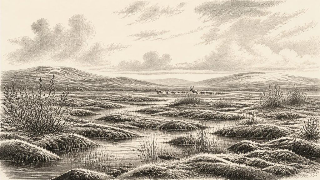
The fossils point to open tundra or muskeg-like wetland, not to forest. Sedges, grasses, herbs, mosses and low woody plants occupied waterlogged ground around shallow pools and sluggish channels. Pollen, plant macrofossils and insects together indicate a cold, treeless setting in which frost was a powerful ecological and geological force. Periglacial does not mean lifeless: it describes ground shaped by repeated freezing and thawing, short growing seasons, seasonal waterlogging and thin or discontinuous vegetation. At Derryvree, wet hollows could preserve plants and small animals even while exposed higher ground was austere.
This was not necessarily the condition of every valley or coast simultaneously. Ireland’s western Atlantic exposure, uplands, drainage basins and proximity to growing ice masses produced local differences. Yet the Derryvree record is strong evidence against imagining the island simply as a white, uniform wasteland. It contained freshwater, vegetation and usable animal habitat. It was nevertheless a difficult country in which winter cold, wind, frozen ground and rapid climatic shifts limited the resources available in any one place.
Climate in an Unstable Ice Age
MIS 3 was climatically unstable across the North Atlantic world. Greenland ice-core chronologies record abrupt oscillations between colder stadial and relatively milder interstadial conditions. Irish evidence cannot be matched securely to a particular Greenland event at the resolution of one calendar year, but the Derryvree age range overlaps several such oscillations. Its open vegetation and freshwater sediments are best understood as part of that wider, fluctuating system, not as proof that Fermanagh experienced one unchanging climate for thousands of years.
Further south-west, calcite formations in Crag Cave, County Kerry, offer a different kind of environmental proxy. Speleothems grow only when liquid water percolates into caves; their episodic growth during MIS 3 indicates intervals when local annual conditions were sufficiently mild for water to circulate. That does not turn Ireland into a temperate refuge. Rather, it reinforces the picture of a climatically variable western edge of Europe, where cold phases, milder episodes, ice growth and changing drainage repeatedly rearranged the landscape.
By this stage global sea level was much lower than today because great quantities of water were held in continental ice sheets. But the physical geography around Ireland cannot safely be reduced to a simple map of exposed land. Local relative sea level was also affected by the weight, growth and movement of ice, while shorelines changed through time. It is therefore unsafe to assert a particular land bridge, crossing route or coastline for 31,731 BCE. Animals and, if present, people faced a changing north-west European margin, not the familiar island geography of the modern Republic and Northern Ireland.
Animals and the Cave Record
Ireland’s best evidence for larger animals of this earlier Late Pleistocene phase comes principally from cave collections, especially Castlepook Cave near Doneraile in north County Cork. Excavations led by Richard J. Ussher and colleagues between 1904 and 1913 recovered a remarkable assemblage from what was then often called Mammoth Cave. It included remains attributed to cold-stage animals such as reindeer, woolly mammoth, wolf, Arctic fox, brown bear, giant deer and spotted hyaena. The assemblage demonstrates that Ireland formed part of wider animal movements in the north-west European region during the Ice Age.
It does not, however, give a reliable wildlife census for this one notional year. Early cave excavation lacked modern standards of stratigraphic recording, sieving and spatial plotting. A cave is also not a neutral sample of a surrounding landscape: it may act as den, shelter, trap, bone-collecting hollow and drainage route. Modern redating has shown that some older radiocarbon results from Castlepook were too young, in part because of limitations in earlier bone-treatment methods. Revised work places elements of the fauna much further back in MIS 3 and suggests that giant deer and spotted hyaena may have disappeared locally before the Last Glacial Maximum, perhaps around 40,000 calibrated years BP.
Accordingly, mammoth, hyaena, deer and reindeer should not be assembled into a single imaginary herd beside the Awbeg in 31,731 BCE. The evidence supports a succession of animal communities across a long climatic phase. Reindeer are particularly relevant to the open vegetation indicated at Derryvree: they could exploit tundra plants and seasonal grazing. Carnivores, meanwhile, followed prey, scavenged carrion and used sheltering places. Their presence reminds us that a bone bearing marks, or found in a cave, need not automatically record human action.
The Human Question
A reindeer femur from the Castlepook collection has made this period exceptionally important for Irish prehistory. It has been reported as dating to about 33,000 years ago and carries a deep linear mark interpreted by zooarchaeologist Ruth Carden as a fresh-bone cut or chop made with a sharp stone implement. If that identification is sustained, the specimen is potential evidence that people processed a reindeer in Ireland during the earlier Upper Palaeolithic, vastly earlier than the traditionally accepted post-glacial human record.
The claim deserves attention, but also restraint. The radiocarbon result dates the animal bone, not necessarily the exact instant when the mark was made. The specimen derives from an old collection, rather than a recently excavated and securely sealed occupation floor. No associated stone-tool assemblage, hearth, dwelling, burial, ornament, artwork or repeated food-processing deposit of comparable age has been securely established in Ireland. The mark is therefore significant evidence under specialist interpretation, not a licence to reconstruct a village, named people or a continuous population.
If humans did reach Ireland at this time, the most defensible interpretation is of a small, highly mobile hunter-gatherer presence: perhaps a brief incursion, a carcass-processing episode, a seasonal hunting movement or an exploratory journey. This is an inference from the possible bone modification and from Upper Palaeolithic lifeways elsewhere in north-west Europe; it is not directly demonstrated by an Irish camp. Whether the people killed the reindeer, found it already dead, removed hide or sinew, took meat, or cracked the limb for marrow cannot be established from the reported incision alone.
Society Without a Historical Record
There is no evidence from Ireland around this point for political institutions, rulers, territorial states, diplomacy, organised warfare or formal alliances. Nor can archaeology identify a language, ethnic name, kin group or ancestry from the Derryvree sediments and Castlepook bones. It would be misleading to turn ecological competition among predators into human conflict, or to project later Irish peoples backwards across more than thirty millennia.
Religion and culture are similarly beyond direct recovery. No shrine, grave, image, musical object or personal ornament securely belongs to this date in Ireland. A possible stone-tool cut on bone would imply practical knowledge of sharp-edged lithic technology, but no particular tool is tied to the femur. It cannot reveal what people believed, taught children, remembered about places or how they organised themselves. The absence of such evidence is not evidence that people lacked culture; it is a limit imposed by preservation and discovery.
“Economy” must also be used carefully. There is no sign of farming, domestic livestock, pottery, metalworking, fields, markets or trade networks in Ireland at this time. Any visitors would have relied on wild resources: animal meat, marrow, hides, sinews, fuel and perhaps seasonally available plants. Their ability to endure would have depended on mobility, detailed environmental knowledge and social co-operation, but these are reasonable general inferences rather than recorded Irish facts. There is no basis for claiming regular trade across the sea or permanent control of territory.
The Coming Transformation
The most important development illuminated by 31,731 BCE is therefore environmental rather than political: Ireland was approaching a profound transformation as the last ice sheet expanded. Research on glacial landforms and dates indicates that substantial areas were still ice-free around the earlier part of this period, while later advances overwhelmed much of the island. The eventual Last Glacial Maximum would erase, bury and fragment earlier landscapes, leaving cave collections and rare protected deposits such as Derryvree as incomplete witnesses.
For this reason, Derryvree’s sealed freshwater bed is more than an obscure road-cut discovery. It preserves evidence for an Ireland of tundra wetlands and shifting ecological opportunity before the later Ice Age maximum. Castlepook raises the tantalising possibility that people briefly entered that world. Neither archive provides a year-specific human story. Together, however, they show that Ireland around this broad interval was environmentally dynamic, inhabited by cold-adapted fauna, and perhaps visited by humans whose traces remain exceptionally slight.
Primary Sources
- A Middle Midlandian Freshwater Series at Derryvree, Maguiresbridge, County Fermanagh, Northern Ireland
- A Reconsideration of the Radiocarbon Dating of the Marine Isotope Stage 3 Fauna from Southern Ireland
- The Timing and Magnitude of the British–Irish Ice Sheet Between Marine Isotope Stages 5d and 2
- Trimlines, Blockfields and the Vertical Extent of the Last Ice Sheet in Southern Ireland
- Growth and Retreat of the Last British–Irish Ice Sheet, 31,000 to 15,000 Years Ago: The BRITICE-CHRONO Reconstruction
- Pattern and Timing of Retreat of the Last British-Irish Ice Sheet
- Radiocarbon Constraints on the Age of the Maximum Advance of the British-Irish Ice Sheet in the Celtic Sea
- The Irish Quaternary Fauna Project
- Episodic Speleothem Deposition Tracks the Terrestrial Impact of Millennial-Scale Last Glacial Climate Variability in SW Ireland
- The IntCal20 Northern Hemisphere Radiocarbon Age Calibration Curve (0–55 cal kBP)
- A 60,000 Year Greenland Stratigraphic Ice Core Chronology
- First Evidence of a Late Upper Palaeolithic Human Presence in Ireland
- New Insights on the Fauna of Ireland's Younger Dryas and Early Holocene from Alice & Gwendoline Cave
- Irish Pleistocene Biostratigraphy
- The Quaternary of Ireland: A Field Guide
- Archaeological Heritage of County Cork
- Reindeer Bone Found in Cork Cave Shows Human Activity in Ireland 33,000 Years Ago
- New Data for the Last Glacial Maximum in Great Britain and Ireland
- Dimensions and Chronology of the Last Ice Sheet in Western Ireland
- NOAA/WDS Paleoclimatology: North GRIP Greenland Ice Core Chronology 2005 (GICC05) 60,000 Year, 20 Year Resolution
