
Derryvree’s Open-Water Interval31712 BCE
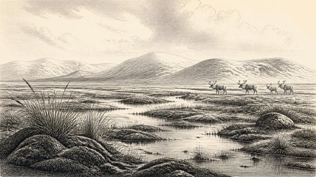
31,712 BCE is a modern label for a broad late Marine Isotope Stage 3 interval, not a recoverable annual date. At Derryvree, County Fermanagh, freshwater silts between glacial tills record an ice-free phase, supporting cold, open wetlands of mosses, sedges, grasses, insects and sparse shrubs. Comparable deposits and Kerry cave calcite demonstrate repeated climatic oscillations. Southern caves preserve mammoth, reindeer, giant deer, predators and other fauna, although dates and deposits require caution. No secure evidence establishes human settlement; a possibly cut reindeer bone suggests only a potential brief visit. Later British–Irish Ice Sheet expansion transformed and buried this periglacial landscape.
Dateline
The label 31,712 BCE is a modern chronological convenience, not a date recoverable from an Irish calendar, historical record or human memory. In the conventional archaeological scale measured from AD 1950, it falls about 33,661 years before present: roughly 33.7 thousand calendar years ago. At that depth of time, neither a radiocarbon determination nor a buried sediment bed can identify a particular year, season or generation. Radiocarbon ages must be calibrated against changing atmospheric carbon levels, and their results are expressed as ranges. This article therefore concerns Ireland during the later part of Marine Isotope Stage 3 (MIS 3), a climatically unstable phase of the Late Pleistocene, rather than inventing an event for one numbered year.
There was no Ireland in the political, cultural or territorial sense of later centuries. No kingdom, people-name, language, treaty, battle, religion or settlement is demonstrable here. What can be responsibly reconstructed is an environmental history, based on sediment, pollen, plant remains, fossil insects, cave bones, glacial landforms and scientific dating. It is a fragmentary record, but it shows that parts of the landmass now called Ireland supported cold-stage life before the later expansion of the British–Irish Ice Sheet transformed much of the terrain.
Dating a Changing Landscape
The most valuable caution is chronological. An age of 30,500 radiocarbon years before present is not equivalent to 30,500 calendar years. The amount of radiocarbon in the atmosphere has fluctuated substantially through time, so a laboratory measurement must be compared with an internationally maintained calibration curve. IntCal20 extends the Northern Hemisphere curve to 55,000 calibrated years before present, but it does not turn every Pleistocene sample into a precise annual date. The uncertainties widen markedly at this age, while older samples, their preparation and the histories of their deposits can be reassessed as methods improve.
For 31,712 BCE, the appropriate frame is a broad one: later MIS 3, before the maximum of the last glaciation. The Last Glacial Maximum was not a single moment everywhere, and the British–Irish Ice Sheet grew and retreated asynchronously. Recent reconstruction places its sustained growth from about 31,000 to 26,000 years before present, with its greatest total volume around 23,000 years before present. The nominal date considered here is therefore earlier than that documented growth phase, though ice, snowfields and upland glaciers were already important regional forces and the evidence for any one ice margin remains incomplete.
Freshwater Beneath a Drumlin
The closest Irish archive for this broad interval lies at Derryvree near Maguiresbridge, County Fermanagh. Road construction exposed organic freshwater silts and fine sands enclosed between two layers of glacial till. That simple sequence is historically powerful. The lower till records an earlier ice advance; the silts and sands accumulated after ice had withdrawn or ceased to cover the locality; the upper till records later renewed glaciation. Derryvree thus preserves a rare interval when this part of Ireland was not beneath moving glacier ice.
The principal organic sample produced a conventional radiocarbon determination of 30,500 with a substantial asymmetric uncertainty of plus 1,170 and minus 1,030 years. Published discussion has placed its calibrated implications broadly at about 36,900–31,700 calibrated years before present. That is a range of several millennia, not a date for the end of 31,712 BCE; nevertheless, the modern year-label lies within its relevant chronological neighbourhood. The deposit supports an interpretation of an ice-free freshwater environment in Fermanagh during part of late MIS 3. It cannot tell us that every part of Ireland shared its conditions at the same moment.
Derryvree is especially valuable because later glaciation protected the sediments even as it remade the surrounding ground. Elsewhere, ice erosion, redeposition, rising seas and thousands of years of soil formation have removed or obscured comparable surfaces. The familiar drumlin landscape of Fermanagh is itself evidence of that later glacial power. Beneath one of those streamlined hills, however, the silts retained a small but important environmental archive.
Mosses, Sedges and Frost
Pollen, plant macrofossils, mosses and insect remains from Derryvree point to an open, mostly treeless periglacial landscape. It has often been described as tundra or muskeg: wet, moss-rich ground with sedges, grasses and herbs, low shrubs in suitable places, and shallow freshwater pools or channels. This was not a uniform white wilderness. During the growing season, plants could establish around waterlogged hollows and exposed ground; organic matter accumulated in sheltered wet places. Yet it was a landscape shaped by long cold winters, short productive summers, frost action and unstable drainage.
The evidence does not justify a neat map of vegetation. Pollen preservation was limited, and isolated grains of tree pollen need not prove nearby forest: pollen can travel long distances or be redeposited. The stronger inference comes from the combined evidence, which favours sparse, open vegetation rather than established woodland. Comparable inter-till sequences at Hollymount in Fermanagh and Aghnadarragh near Lough Neagh demonstrate that Ireland’s Late Pleistocene record contains repeated changes between glacial and non-glacial conditions, not a single continuous freeze.
Evidence from Crag Cave in County Kerry adds a different kind of environmental signal. Uranium-series dates from cave calcite show episodic speleothem growth through the last glacial period, broadly coinciding with warmer Greenland interstadials. Calcite formation requires water to move through the cave system and is unlikely under persistently frozen conditions. It does not mean that Kerry’s weather duplicated Fermanagh’s, or that every mild episode was comfortable by modern standards. It does show that the Irish Atlantic margin experienced pronounced climatic oscillations within the long cold stage.
Animals in the Southern Caves
In southern Ireland, caves preserve another partial view. Castlepook Cave near Doneraile, County Cork, yielded remains of woolly mammoth, reindeer, giant deer, spotted hyaena, brown bear, wolf, Arctic fox, hare and lemmings. The Irish Quaternary Fauna Project established that a broad range of mammals reached Ireland between at least about 45,000 and 20,000 years ago. That finding corrected older assumptions that Pleistocene Ireland had been almost devoid of large animals.
It would nevertheless be wrong to paint all these species together in one exact scene for 31,712 BCE. A cave bone is evidence that a species existed in the region at some point within a dated range; it is not a census of a single valley. Cave assemblages are also difficult archives. Carnivores carried in prey and scavenged carcasses, animals may have died in natural traps, water could move bones between deposits, and nineteenth- and early twentieth-century excavations did not preserve the stratigraphic controls expected today. The Castlepook collections have been particularly important because later work found that some older radiocarbon dates were too young by thousands of years.
Even with those limits, the faunal evidence is striking. Reindeer and lemmings accord with cold, open environments; mammoth and giant deer point to extensive feeding grounds, though not necessarily to permanent local herds. Spotted hyaena and wolf indicate predators and scavengers operating within a more complex food web than that of later historic Ireland. The animals moved in response to forage, snow cover, predators and changing land corridors. Their presence is evidence of ecology, not of human management, hunting territories or trade.
The Unsettled Human Question
There are no securely dated houses, hearths, occupation layers, stone-tool assemblages, burials or food-processing sites in Ireland from around 33.7 thousand years ago. Consequently, political affairs, conflict, diplomacy, social rank, everyday domestic life, art, language, ritual, religious belief and learning cannot be described as Irish history at this date. No economy of farming, herding, craft production or exchange is evidenced. The National Museum of Ireland continues to state that clear evidence for human presence during the Irish Palaeolithic has not emerged.
A reindeer femur from the Castlepook collection has, however, reopened the question. Zooarchaeologist Ruth Carden identified a deep mark interpreted as having been made on fresh bone by a sharp stone tool during carcass processing; County Cork heritage material presents the object as dating to about 31,000 BCE. If the mark is confirmed as anthropogenic and contemporary with the animal’s death, it would be important evidence for a brief Upper Palaeolithic human visit. It remains one modified bone from an old, complex cave collection, not proof of a resident population, a camp or a community. Recent excavation at Castlepook, supported by the Royal Irish Academy, reflects the need for better-controlled evidence.
Human groups certainly lived elsewhere in north-west Europe during the Upper Palaeolithic. Lower sea levels placed coastlines farther from their modern positions, but the practical routes into Ireland, the duration of any crossings or land connections, and the frequency of visits remain uncertain. It is reasonable to say that people may have reached the island in favourable circumstances; it is not reasonable to assign them a culture, a religion or political relationships without Irish archaeological contexts.
A Precarious Interval
The most responsible portrait of Ireland around 31,712 BCE is therefore neither an empty void nor a populated Ice Age drama. It is a cold, variable landmass in which some lowland places, including the Derryvree locality, could sustain freshwater wetlands, mosses, sedges, insects and visiting or resident animals during an ice-free interval. In the south, cave deposits preserve traces of a richer mammal fauna, while also warning how easily deposits can mix and dates be revised.
The large ice-sheet expansion lay ahead. As ice accumulated and extended in later millennia, it altered drainage, buried deposits, reworked sediments and narrowed the ecological opportunities recorded at Derryvree and Castlepook. The enduring historical significance of this nominal year is thus environmental: it falls within a broad calibrated horizon when Ireland was still a changing mosaic of cold open ground, freshwater pockets and animal movement, before the ice sheet reached its later dominance. Evidence supports that much; beyond it, restraint is part of the history.
Primary Sources
- A Middle Midlandian Freshwater Series at Derryvree, Maguiresbridge, County Fermanagh, Northern Ireland
- The Irish Quaternary Fauna Project
- A Reconsideration of the Radiocarbon Dating of the Marine Isotope Stage 3 Fauna from Southern Ireland
- Growth and Retreat of the Last British–Irish Ice Sheet, 31,000 to 15,000 Years Ago: the BRITICE-CHRONO Reconstruction
- The Timing and Magnitude of the British–Irish Ice Sheet Between Marine Isotope Stages 5d and 2: Implications for Glacio-Isostatic Adjustment, High Relative Sea Levels and ‘Giant Erratic’ Emplacement
- New Data for the Last Glacial Maximum in Great Britain and Ireland
- Extent and Timing of the Last Glacial Maximum (LGM) in Britain and Ireland: a Review
- Episodic Speleothem Deposition Tracks the Terrestrial Impact of Millennial-Scale Last Glacial Climate Variability in SW Ireland
- The IntCal20 Northern Hemisphere Radiocarbon Age Calibration Curve (0–55 cal kBP)
- IntCal: History
- Freshwater Organic Deposits and Stratified Sediments Between Early and Late Midlandian (Devensian) Till Sheets at Aghnadarragh, County Antrim, Northern Ireland
- An Inter-Till Freshwater Deposit at Hollymount, Maguiresbridge, Co. Fermanagh
- Irish Pleistocene Biostratigraphy
- New Insights on the Fauna of Ireland’s Younger Dryas and Early Holocene from Alice & Gwendoline Cave
- Investigating Seasonal Mobility in Irish Giant Deer Megaloceros giganteus Through Strontium Isotope Analysis
- Prehistoric Details
- Stone Age
- Heritage Artefacts of County Cork
- 2022:564 — Castlepook Cave, Castlepook South, Cork
- Irish Association for Quaternary Research Field Guide
