Derryvree’s Frostwater Flora31682 BCE
Around 31,682 BCE, Ireland was an unstable later-MIS 3 Ice Age landscape, not a documented human society. Derryvree, County Fermanagh, preserves freshwater organic sediments between glacial tills, indicating an ice-free interval with tundra-like wetlands, mosses, sedges, aquatic plants and cold-adapted insects. Cave evidence and speleothems show environmental variation, while advancing ice sheets increasingly reshaped the island before the later Last Glacial Maximum. Castlepook Cave fauna, including reindeer, mammoth and hyena, reflects changing Pleistocene ecosystems rather than a single community. A possibly cut-marked reindeer bone suggests early human activity, but lacks corroborating archaeological context. Evidence remains fragmentary and interpretations necessarily cautious.
Dateline
The label 31,682 BCE is a modern chronological convenience, not a year that anyone in Ireland could have named, recorded or commemorated. It corresponds approximately to 33,632 calendar years before 1950, the conventional reference point for cal BP dates. At this depth of time, calendar-year precision is not available. Radiocarbon determinations have sizeable uncertainties, must be calibrated, and date the death of an organism or formation of a deposit rather than an event in a historical narrative. Ireland therefore has no responsible “year-by-year” story for this point. What can be reconstructed is a broad environmental setting in the later part of Marine Isotope Stage 3 (MIS 3), a climatically unstable interval of the last Ice Age.
An Interval, Not a Chronicle
Modern Ireland did not yet exist as a political community, a cultural region with recorded traditions, or a settled landscape of farms, roads and monuments. There were no kingdoms, diplomatic agreements, battles, shrines, markets or written learning to describe. Nor is there evidence from this period for a securely established human population on the island. The historical record is geological and biological: sediments trapped beneath later ice, pollen grains, plant macrofossils, insect remains, cave bones, isotope measurements and the landforms left by glaciers.
The most useful Irish comparison for this nominal date comes from Derryvree, near Maguiresbridge in County Fermanagh. Roadworks in 1969 cut through a drumlin and exposed a remarkable sequence: freshwater silts and fine sands, rich in organic material, lay between two distinct sheets of glacial till. Till is sediment deposited directly by moving ice. The sequence consequently shows three broad stages: ice affected the locality; a freshwater environment and cold-adapted vegetation developed; and ice later returned or expanded across the ground. It is an unusually valuable survival from a landscape otherwise repeatedly eroded and rearranged by glaciation.
The organic layer at Derryvree produced a conventional radiocarbon determination of 30,500 years BP, with a substantial error margin. In calibrated terms, later scholarship has treated it as falling broadly within about 36,900–31,700 cal BP. The nominal date of 31,682 BCE lies close to the younger edge of that wide range, but this does not make Derryvree a deposit formed in that specific year. Rather, it offers the closest available Irish window onto the kind of cold-stage environment that may have existed around this point in time.
Mosses, Sedges and Shallow Water
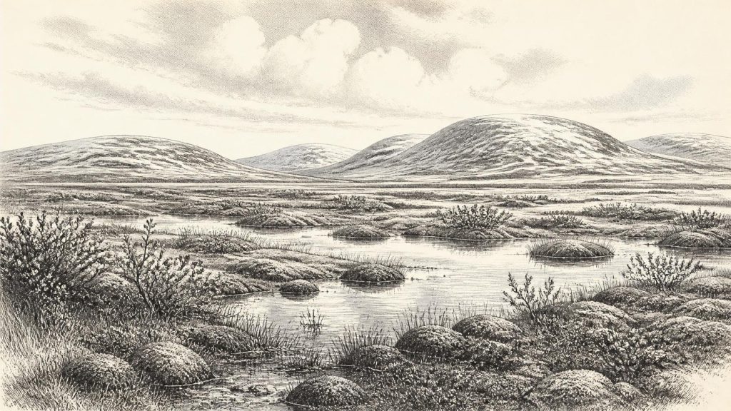
Derryvree overturns any simple image of an entirely frozen, lifeless Ireland. Its pollen was poorly preserved, and cannot be used to draw a detailed island-wide vegetation map. Even so, herb pollen, freshwater mosses, sedges, aquatic plants and cold-climate insects point clearly towards open, treeless or almost treeless ground. Researchers described the setting as tundra and muskeg: wet, mossy, peat-forming terrain broken by pools, channels and patches of sedge-rich vegetation. Fossil evidence includes plants such as bogbean, dwarf willow and lesser clubmoss, species well suited to cool, exposed and often waterlogged conditions.
This was not the familiar green, wooded Ireland of the Holocene, nor necessarily a blank expanse of snow. In the growing season, shallow water and damp hollows could sustain mosses, herbs, insects and grasses. Local shelter, soil moisture, slope and drainage would have produced ecological variation at a small scale. Exposed ridges and frost-disturbed surfaces may have been sparse, while basin edges were more productive. Winters were severe, and the short season for plant growth imposed limits, but freshwater sediment could still accumulate and small wetland communities could thrive.
Evidence from Crag Cave near Castleisland, County Kerry, supports the larger point that late Ice Age conditions changed markedly rather than remaining uniformly frozen. Uranium-thorium dates show that speleothems, the calcite formations commonly called stalagmites and stalactites, grew episodically during MIS 3. Their formation requires water to circulate through the cave and is associated with intervals when mean annual conditions were sufficiently mild for liquid water. This does not prove that County Kerry and County Fermanagh had identical climates at the same moment. It does demonstrate that Ireland’s long cold stage contained environmental fluctuations and locally habitable, biologically active intervals.
Ice in Motion
At approximately 33,600 cal BP, Ireland was approaching the major growth phase of the last British–Irish Ice Sheet, but the evidence does not support a single, simple picture of the entire island already buried beneath continuous ice. Reviews of the glacial record place the broad build-up of the ice sheet after roughly 35,000–32,000 years ago, while its greatest overall extent came later, during the Last Glacial Maximum, conventionally placed around 27,000–21,000 years ago. Different sectors advanced, thickened and retreated on different schedules. Ice divides, outlet glaciers, meltwater routes and surrounding seas all changed through time.
Derryvree is important precisely because it preserves an ice-free episode between two glacial events in north-central Ireland. Comparable inter-till or sub-till deposits at Hollymount and Greenagho, also in Fermanagh, show that this region retains fragments of a longer, complex sequence. These deposits do not establish the precise position of every ice margin in 31,682 BCE. They do rule out an overly neat narrative in which Ireland was either wholly ice-covered or wholly ice-free throughout MIS 3. The island’s physical geography was being made and remade by climate shifts over millennia.
Lower global sea levels exposed more of the continental shelf than is visible today, altering coastlines and potential dispersal routes for animals. Yet the exact palaeogeography between Ireland, Britain and continental Europe remains a matter for careful reconstruction, not assumption. It is unsafe to imagine an uncomplicated land bridge across which people and animals simply walked at any chosen date. Glaciers, water bodies, exposed lowlands and changing sea levels created different barriers and opportunities at different times. The routes by which animals reached Ireland remain part of the wider Quaternary problem.
The Cave Fauna of Cork
Southern Irish caves provide another line of evidence. Castlepook Cave, also called Mammoth Cave, near Doneraile in north County Cork, yielded bones of a striking Pleistocene fauna during excavations in the early twentieth century. The assemblage includes spotted hyena, reindeer, woolly mammoth, giant deer, brown bear, wolf, Arctic fox, hare and small cold-adapted mammals. These finds show that Ireland was, at various times during the later Pleistocene, part of a wider north-west European ecological zone in which large herbivores, predators and scavengers moved through open landscapes.
That statement needs an important qualification. A cave bone collection is not automatically a census of animals living together on one day or even in one century. Bones may have been brought into caves by hyenas, accumulated in separate episodes, shifted by water, disturbed by burrowing animals or mixed by antiquarian excavation. Direct dating has improved the picture, but individual specimens still have individual histories. Recent reassessment indicates that some of the older Castlepook fauna, including spotted hyena and giant deer, may belong earlier in MIS 3 and may have disappeared locally before the Last Glacial Maximum. The site reveals a changing faunal mosaic, not a fixed Ice Age menagerie.
At the broad timescale of 31,682 BCE, reindeer are especially significant. A reindeer femur from the old Castlepook collection has been reported as dating to around 33,000 years ago and bears a deep linear mark interpreted by zooarchaeologist Ruth Carden as a cut or chopping mark made with a sharp stone tool on fresh bone. If that interpretation is confirmed, it would be potentially transformative: it would indicate that a person processed a reindeer in Ireland in the broad era considered here, far earlier than the previously secure evidence of terminal Pleistocene human activity.
The Human Question
The proper conclusion remains cautious. The radiocarbon result dates the animal bone, not automatically the mark, the animal’s place of death, or the duration of any human visit. Identifying a surface modification as a stone-tool cut is a separate taphonomic judgement, particularly important in a cave where carnivore damage, weathering and old excavation methods complicate interpretation. No securely associated stone-tool assemblage, hearth, dwelling floor, human burial, artwork or repeated occupation layer of comparable age has yet been published from Castlepook.
It follows that there is no basis for describing a settlement, a permanent population, an ethnic community, a language or a social hierarchy in Ireland at this date. If people did reach the island, the marked femur could represent a brief episode: scavenging a carcass, butchering an animal killed elsewhere, or a short hunting incursion within a much wider mobile world. It does not prove continuity between any such visitors and the island’s much later inhabitants. Renewed excavation at Castlepook is valuable because stratified deposits may eventually test old claims against securely recorded contexts.
Consequently, politics, conflict, diplomacy, religion and formal culture are absent from the evidence—not because they can be confidently said never to have existed among possible visitors, but because Ireland has no material record capable of demonstrating them here. Nor can an economy or trade network be reconstructed. The only defensible economic observation is ecological: animals depended on seasonal forage and water, while any visiting people would have had to obtain food, fuel, shelter and workable stone in an unpredictable cold environment.
What This Date Can Mean
Ireland around 31,682 BCE is best understood as a changing Ice Age landscape on the threshold of more extensive glaciation. At Derryvree, freshwater, sedges, mosses and cold-adapted insects record an open periglacial wetland later sealed beneath ice. At Castlepook, cave bones attest to the intermittent presence of large mammals and carnivores within a wider Pleistocene ecosystem. One marked reindeer bone raises a serious but unresolved possibility of early human activity. Together, these traces replace invented certainty with something more compelling: an Ireland shaped by moving ice, unstable climate, short productive summers and rare archaeological survivals whose meanings are still being tested.
Primary Sources
- A Middle Midlandian Fresh-Water Series at Derryvree, Maguiresbridge, County Fermanagh, Northern Ireland
- Early Midlandian–Middle Midlandian, Pleistocene, Northern Ireland
- Palaeoecology: Irish Quaternary Association Field Guide
- The Subdivision of the Quaternary Period in Ireland
- A Reconsideration of the Radiocarbon Dating of the Marine Isotope Stage 3 Fauna from Southern Ireland
- The Irish Quaternary Fauna Project
- Spotted Hyena Skull
- Castlepook Cave, Cork, 2022 Excavation Report
- Episodic Speleothem Deposition Tracks the Terrestrial Impact of Millennial-Scale Last Glacial Climate Variability in SW Ireland
- The IntCal20 Northern Hemisphere Radiocarbon Age Calibration Curve (0–55 cal kBP)
- Extent and Timing of the Last Glacial Maximum in Britain and Ireland: A Review
- Growth and Retreat of the Last British–Irish Ice Sheet, 31,000 to 15,000 Years Ago: The BRITICE-CHRONO Reconstruction
- BRITICE Glacial Map, Version 2: A Map and GIS Database of Glacial Landforms of the Last British–Irish Ice Sheet
- Exploring Controls on the Last Deglaciation of the Marine Sectors of the British–Irish Ice Sheet
- A Critical Review and Re-Investigation of the Pleistocene Deposits Between Cranfield Point and Kilkeel, Northern Ireland
- Ireland: Submerged Prehistoric Sites and Landscapes
- The Problem of a Late Quaternary Landbridge Between Britain and Ireland
- New Insights on the Fauna of Ireland's Younger Dryas and Early Holocene from Alice & Gwendoline Cave
- Heritage Artefacts of County Cork
- Ireland's Palaeolithic Archaeology – Fleeting Footprints in a Frozen Land
