
Derryvree’s Mossland30849 BCE
Around 30,849 BCE, Ireland lay within the climatically unstable Late Pleistocene MIS 3, not a recoverable historical year. At Derryvree in County Fermanagh, freshwater sediments sealed between glacial tills record a locally ice-free interval around 33,500 years ago. Pollen, plants and insects indicate cold, treeless wetland with mosses, sedges, shallow pools and sparse vegetation. Castlepook Cave in County Cork yielded diverse Ice Age mammals, including mammoth, giant deer, reindeer and hyaena, accumulated over millennia. A possibly tool-marked reindeer bone suggests early human activity, but no secure evidence establishes settlement or population. These fragile records depict changing habitats before wider glaciation.
Dateline
30,849 BCE is not a recoverable Irish year. It is a modern calendar label, roughly 32,800 years before AD 1950, used to position a remote point in the Late Pleistocene. No calendar, written tradition, named community or excavated settlement allows an event in Ireland to be assigned to this particular year. The appropriate history is therefore one of broad, dated environmental horizons. Around this point lay Marine Isotope Stage 3 (MIS 3), a long and climatically unstable portion of the last glacial cycle, before the fullest development of the British–Irish Ice Sheet.
A Date Within a Range
The most important Irish evidence relevant to this horizon comes from Derryvree, near Maguiresbridge in County Fermanagh. Road construction in 1969 cut through a drumlin and exposed a remarkable sequence: glacial till below, freshwater silts, fine sands and organic material in the middle, and another till above. Till is unsorted debris deposited by glacier ice. The sequence therefore establishes a relative history with unusual clarity: ice affected the locality; an interval followed in which water, plants and small animals left sediments; then a later ice advance or ice-related deposition buried the record.
Organic material from the Derryvree bed produced the radiocarbon determination BIRM-166, 30,500 +1,170/−1,030 radiocarbon years BP. A radiocarbon age is not a calendar age. It must be calibrated because atmospheric carbon-14 levels varied through time, and at this antiquity the resulting probability ranges are broad. A recent ice-sheet chronology that incorporates the legacy date places the relevant ice-free phase at about 33.5 ± 1.2 thousand calendar years BP, approximately 34,700–32,300 cal BP at one standard deviation. The modern label 30,849 BCE falls within that broad modelled interval. It does not date a particular pool, plant, animal or human action.
Wet Ground Between Glaciers
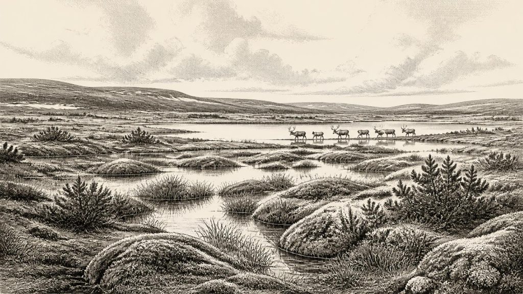
Derryvree is evidence for local conditions, not a map of the entire island. Nevertheless, its plant and insect remains offer Ireland’s clearest close view of the environment around this period. Investigators identified pollen dominated by herbaceous plants, plant macrofossils and a rich moss flora. Grasses, sedges, juniper and other herbs indicate open, treeless ground. Aquatic and wetland plants, together with insect evidence, point to shallow pools, waterlogged margins and organic-rich mud. The landscape has often been described as muskeg: a cold, wet mosaic of mossy ground, sedge-rich hollows and standing water rather than the familiar wooded and pastoral Ireland of later millennia.
That description must be kept in scale. Fossils from a single basin reveal the vegetation that grew nearby and the habitats feeding its waters; they cannot establish identical conditions in every Irish valley, coast or upland. They do, however, rule out a warm, continuous forest around Derryvree. Winters were severe, cover was sparse in places, and exposed terrain lay close to freshwater refuges. Seasonal thaw, snow, frost and meltwater would have mattered more to life than any fixed modern distinction between ‘land’ and ‘lake’.
An Island of Shifting Opportunities
Ireland was not continuously buried beneath ice throughout MIS 3. The Derryvree sediments demonstrate an interval without local glacier cover in Fermanagh, while modern reconstructions suggest that ice was beginning to accumulate in Irish uplands and northern sectors during the wider period. This was not yet the later maximum, when ice covered much of Ireland and extended onto surrounding shelves. The crucial theme is change: cold phases, advancing and retreating ice margins, lower sea levels and altered coastlines repeatedly reorganised habitats.
Lower sea level changed the geography of the Irish Sea basin, but the exact routes available to any animal, and at any moment, cannot be reconstructed for 30,849 BCE. The presence of continental mammals proves that dispersal occurred during favourable parts of the Late Pleistocene. It does not prove a permanent land bridge, a single migration route or an uninterrupted connection with Britain and continental Europe. In this setting, regional change was ecological before it was social: suitable grazing, shelter, water and passage could expand or disappear over generations.
The Castlepook Fauna
At Castlepook Cave near Doneraile in north County Cork, a very different archive preserves the bones of Ice Age mammals. Geological Survey Ireland regards it as Ireland’s richest vertebrate-fauna site for the period leading towards the Last Glacial Maximum. More than 2,000 bones have been recovered. The assemblage includes woolly mammoth, giant deer, reindeer, brown bear and spotted hyaena, with wolf, fox or Arctic fox, stoat, mountain hare and lemmings also represented in deposits of differing age.
These remains make the southern Irish landscape less empty than older caricatures of an ice-age wilderness. Open country could support grazers and browsers, while large predators and scavengers exploited them. Yet Castlepook is a cave repository accumulated over a long span, not a single frozen moment. Individual bones have dates extending broadly from about 45,700 to 19,950 years BP, and water movement, excavation history and carnivore activity have disturbed their original relationships. It would be wrong to place every recorded species together in one herd, or to claim that all lived in Cork in the notional year addressed here.
A Possible Human Trace
A reindeer femur from Castlepook has attracted exceptional attention because a deep mark has been interpreted as damage made to fresh bone by a sharp stone tool during carcass processing. The bone has been publicly associated with an age of about 33,000 years. If the interpretation and association are sustained by further analysis, it may be evidence that people handled a reindeer carcass in Ireland far earlier than the securely documented post-glacial settlement record.
The limits are as important as the possibility. There is no securely associated hearth, stone-tool assemblage, dwelling floor, burial, camp or repeated occupation surface from this horizon. Nor can one modified bone tell us whether people killed the animal, found it, processed it elsewhere, stayed briefly, travelled in a small party or returned. Castlepook also contained hyena remains and bones affected by carnivores, so it should not be imagined as a human home. The responsible conclusion for this date is that very early human activity is possible, not that Ireland possessed an established Palaeolithic population.
No Polities, No Trade Network
There is no evidence for political authority, diplomacy, warfare, territorial institutions, agriculture, villages, exchange networks or seaborne trade in Ireland at this depth of time. Such categories belong to later evidence, not to the Derryvree and Castlepook records. If people did reach the island, their social organisation, language, beliefs and knowledge are archaeologically unknowable here. No Irish art, ornament, ritual structure or burial can responsibly be assigned to this horizon. The absence of evidence is not proof that thought, custom or cooperation were absent from any visitors; it is a boundary on what the surviving record can demonstrate.
Likewise, there is no basis for reconstructing an Irish economy beyond the ecological possibilities suggested by the fauna. Reindeer, giant deer and other mammals could have offered meat, hide, bone and antler to any human group able to obtain them, but possibility is not evidence of a regular subsistence system. Derryvree’s pools and wet ground would have supported insects, plants and small animals, while the wider open landscape offered grazing. These were resources in a landscape, not proof of settlement or organised exploitation.
What the Evidence Preserves
The great significance of this period lies partly in its fragility. Later glaciation eroded, redeposited or buried enormous areas of older ground, leaving few places where organic material survived. A freshwater bed sealed between tills and a cave collection assembled over more than a century are therefore disproportionately important. Their value grows when methods improve: radiocarbon pretreatment, calibration, zooarchaeology, microscopic study of bone surfaces, sediment analysis and new excavation can all revise earlier conclusions.
Around 30,849 BCE, then, Ireland is best understood as a changing cold landscape rather than a nation with an annual chronicle. In Fermanagh, Derryvree preserves the strongest indication of treeless wetland, mosses, sedges and shallow water during a locally ice-free interval. In Cork, Castlepook records a varied cold-stage fauna and the tantalising but insufficient hint of human butchery. Together they reveal a biologically active island on the threshold of more extensive glaciation, while insisting on the uncertainty that separates responsible reconstruction from invention.
Primary Sources
- A Middle Midlandian Freshwater Series at Derryvree, Maguiresbridge, County Fermanagh, Northern Ireland
- Palaeoecology
- The Subdivision of the Quaternary Period in Ireland
- Castlepook Cave: Cork County Geological Site Report
- A Reconsideration of the Radiocarbon Dating of the Marine Isotope Stage 3 Fauna from Southern Ireland
- Occurrence of Mammalia Relicts at Site Castlepook Cave
- The Irish Quaternary Fauna Project
- Early Midlandian–Middle Midlandian, Pleistocene, Northern Ireland
- Exploring Controls of the Early and Stepped Deglaciation on the Western Margin of the British-Irish Ice Sheet
- The IntCal20 Northern Hemisphere Radiocarbon Age Calibration Curve (0–55 cal kBP)
- IntCal History
- Growth and Retreat of the Last British–Irish Ice Sheet, 31,000 to 15,000 Years Ago: The BRITICE-CHRONO Reconstruction
- Late Pleistocene Chronostratigraphy and Ice Sheet Limits, Southern Ireland
- Quaternary
- Geology of Ireland
- 2022:564 – Castlepook Cave, Castlepook South, Cork
- Archaeology Research Excavation Grant Report
- Heritage Artefacts of County Cork
- Areas of Scientific Interest in County Cork
- The Geological Heritage of County Leitrim
