
Derryvree’s Tundra Fen30671 BCE
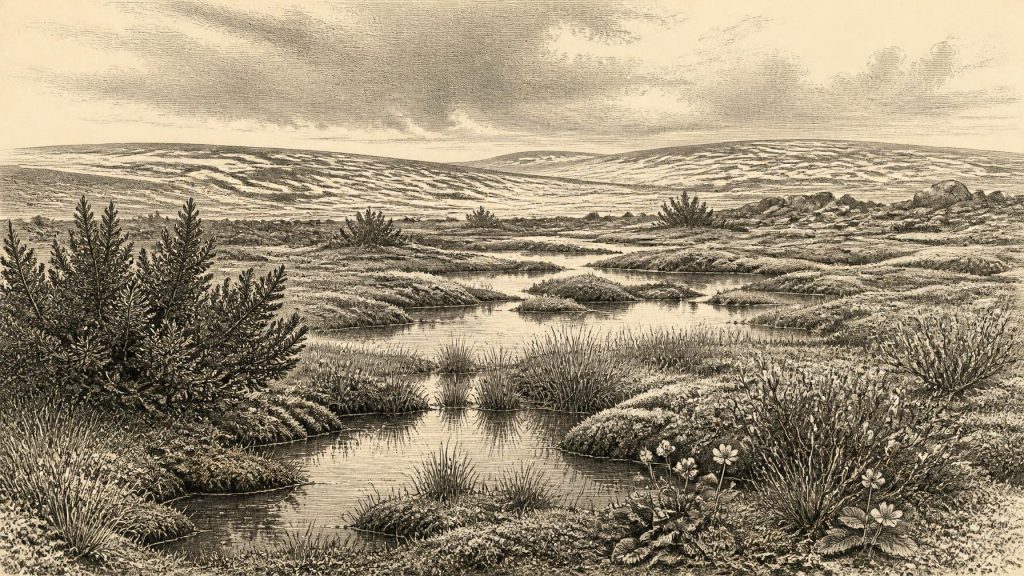
The date 30,671 BCE is not a specific datable Irish event but a notional point within a broad, climatically unstable Late Pleistocene interval. At Derryvree, County Fermanagh, freshwater sediments between glacial tills indicate a treeless tundra wetland with sedges, mosses, Arctic-alpine plants, insects and shallow pools before renewed ice deposition. The site demonstrates regional environmental change rather than an ice-free Ireland. Castlepook Cave, County Cork, preserves cold-stage fauna including mammoth, reindeer and hyaena, confirming connections with wider Europe. A possibly cut-marked reindeer bone suggests but does not prove early human activity. Evidence reveals dynamic habitats, not settlements or year-specific history.
Dateline
A Date Beyond Historical Time
30,671 BCE is a useful modern label, not a date at which an Irish event can be placed. No writing, named people, settlements or calendar system survive from this depth of time. Indeed, the apparent precision is misleading: it lies roughly 32.6 thousand calendar years before the radiocarbon convention of AD 1950, during the Late Pleistocene and Marine Isotope Stage 3 (MIS 3), a climatically volatile part of the last Ice Age. The appropriate history is therefore one of broad, calibrated ranges and physical evidence rather than a narrative of a particular year.
The most relevant Irish record is a buried freshwater deposit at Derryvree, near Maguiresbridge in County Fermanagh. Organic silts and fine sands there produced the radiocarbon measurement BIRM-166: 30,500 radiocarbon years before present, with a substantial uncertainty. Radiocarbon years are not calendar years, because atmospheric carbon-14 has varied through time. Using modern calibration, scholarship places the deposit broadly between about 36,900 and 31,700 calibrated years before present, approximately 34,950–29,750 BCE. The nominal year in this article falls within that wide span, but cannot be assigned to one bed of silt, one season, or one living community.
That distinction is fundamental. Derryvree illuminates conditions around this notional date, not a moment frozen in time. Nor can a single Fermanagh wetland stand for every part of Ireland. Ice, altitude, coast, drainage and exposure to Atlantic weather created marked regional differences, while later glaciers destroyed or concealed much of the older landscape. Yet the site remains an unusually important window because it preserves an ordered sequence of ice, water, vegetation and renewed glaciation.
A Wetland Between Glaciers
Road works in 1969 cut through a drumlin at Derryvree and exposed two thick, distinct layers of till: the unsorted mixture of clay, stones and debris deposited by glacier ice. Between them lay freshwater silts, fine sands and organic material. The basic sequence is secure. Glacier ice had first affected the locality and left the lower till. At a later time, ice no longer overrode that ground; shallow or sluggish fresh water, wet soils, plants and small animals accumulated sediment. Finally, a later ice advance, or ice-related deposition, sealed the wetland beneath the upper till.
This is evidence for environmental change, not for a uniformly ice-free Ireland. The Derryvree bed shows that at least this portion of Fermanagh experienced a non-glacial interval long enough for a freshwater ecosystem to develop. Elsewhere, mountain ice, local glaciers, bare periglacial ground or different wetland conditions may have existed simultaneously. Recent work on the British–Irish Ice Sheet has greatly refined the later history of ice growth and retreat, but its authors also stress how uncertain the pre-Last Glacial Maximum picture remains. Ireland was entering a colder world, not yet settled into the fullest expansion of the later ice sheet.
The Last Glacial Maximum, when the last Irish ice sheet reached its greatest extent, lay in the future, generally placed at roughly 26,000–20,000 years ago. Around the broad Derryvree interval, climate in the North Atlantic changed abruptly between colder stadials and relatively milder interstadials. A landscape could alter profoundly over centuries or millennia: snowfields and glacier margins could grow or shrink, meltwater could rearrange valleys, and an open wetland could be buried beneath ice-derived sediment. Such instability, rather than one fixed ‘Ice Age Ireland’, is the central environmental fact.
Plants, Pools and Open Ground
The fossils from Derryvree point to treeless, open tundra or muskeg: wet, mossy ground broken by pools and waterlogged channels. Grasses and sedges were important, alongside herbs, mosses, juniper and Arctic-alpine plants. Finds recorded from the deposit include dwarf willow, mountain-avens, rosy saxifrage and a seed of bogbean, a plant associated with shallow fresh water and marshy margins. Insect remains likewise indicate a cold freshwater and wetland setting with abundant plant material. Together these are direct evidence for a local ecological community, although not every species need have grown together in every season or through the full life of the deposit.
This was not the densely wooded island familiar from much later prehistory. Trees were absent or extremely limited locally, while low vegetation left the ground exposed to wind, frost and seasonal thaw. The word ‘tundra’ should not suggest a featureless plain. Small variations in shelter, drainage, snow cover and soil could create mossy hollows, sedge beds, stony slopes and shallow pools within a short distance. The Derryvree sequence gives rare substance to that lost terrain: a freshwater place preserved beneath a later drumlin.
Its environment also warns against easy climatic labels. Cold-tolerant plants and insects demonstrate harsh conditions, but they do not yield a single annual temperature or a precise forecast for all Ireland. Nor does the presence of freshwater prove benign weather. A periglacial wetland may have had short growing seasons, severe winters and persistent ground frost. Its significance is that life endured in niches between, beside, or after episodes of ice occupation.
Animals on the Atlantic Margin
South-west Ireland provides a complementary, though differently dated and more complicated, body of evidence. Castlepook Cave near Doneraile, County Cork, contains Ireland’s richest known assemblage of pre-Last Glacial Maximum vertebrate remains. Woolly mammoth, reindeer, giant deer, brown bear and spotted hyaena are among the animals represented; later and differently dated material includes Arctic fox, wolf and lemmings. Direct redating has demonstrated that some Cave bones are considerably older than earlier measurements suggested, underlining both the antiquity of the fauna and the need for caution when treating a cave collection as one contemporaneous herd or landscape.
These animals show that Ireland was repeatedly accessible to cold-stage mammals during MIS 3 and that it formed part of a wider north-west European ecological zone. Mammoths and reindeer did not inhabit an empty wilderness, while hyaenas could carry prey remains into caves and disturb deposits. New sedimentary ancient-DNA research from Castlepook reinforces the picture of faunal connectivity with Eurasian populations before the Last Glacial Maximum. It does not, however, establish the exact route used by every species, or prove a continuous dry-land bridge between Ireland and Britain at 30,671 BCE. Sea level, coastlines, ice margins and shallow seas changed repeatedly.
Neither should the Castlepook fauna be projected wholesale onto Derryvree. The two places lie far apart, preserve different environments, and have different dating and depositional histories. Together, they support a restrained conclusion: parts of Ireland could sustain or be reached by a varied cold-stage fauna during this broad interval. They do not provide a census for one calendar year.
The Human Question
A reindeer femur from Castlepook has been reported as bearing a mark consistent with cutting by a sharp stone tool, and has been presented as possible evidence of human activity in Ireland about 33,000 years ago. If that interpretation is ultimately sustained, it would push the island’s human story far earlier than the securely established Mesolithic settlement of the early Holocene. It would be especially relevant to this general period of MIS 3, when Upper Palaeolithic people lived elsewhere in north-west Europe.
But the evidence cannot responsibly be enlarged into a settled population at the date considered here. The bone came from a cave system affected by older excavations, water movement, carnivores and disturbed deposits; no associated tool assemblage, hearth, dwelling, human remains or securely stratified occupation surface demonstrates a camp. The cut-mark interpretation is important and deserving of continued research, but it does not identify the people involved, their language, numbers, journey or season of arrival. Nor does it show that humans were present in 30,671 BCE itself.
Accordingly, there is no basis for political history, warfare, diplomacy, institutions, religion, formal learning, trade or social hierarchy in Ireland at this point. There is also no evidence for farming, stock-keeping, pottery, metalwork or permanent villages. It would be possible to describe hunter-gatherer lifeways documented elsewhere in Upper Palaeolithic Europe, but that would be comparison rather than Irish evidence. The responsible conclusion is simpler: human presence in pre-Last Glacial Maximum Ireland is possible and may be indicated by one remarkable bone, yet remains unproven as a sustained occupation.
What This Moment Means
For Ireland, 30,671 BCE belongs not to conventional national history but to deep environmental history. The best evidence records a changing island-margin landscape: former ice at Derryvree, a cold treeless wetland during an intervening interval, and later renewed glaciation; animal communities capable of reaching Ireland; and perhaps a fleeting human trace at Castlepook. These fragments matter because they overturn the older, simpler image of an island continuously blanketed by ice until the final thaw.
They also impose limits. The archaeological and geological archive cannot supply a ruler, battle, belief system or year-specific event. Its strength lies elsewhere: in showing how plants, animals, water and ice made – and unmade – habitats long before enduring settlement. Around this nominal date, Ireland was a dynamic Atlantic edge of Ice Age Europe, where a small Fermanagh fen and the bones in a Cork cave preserve the faint, powerful evidence of worlds repeatedly transformed.
Primary Sources
- A Middle Midlandian Freshwater Series at Derryvree, Maguiresbridge, County Fermanagh, Northern Ireland
- Figure 6.— The Subdivision of the Quaternary Period in Ireland
- The IntCal20 Northern Hemisphere Radiocarbon Age Calibration Curve (0–55 kcal BP)
- Growth and Retreat of the Last British–Irish Ice Sheet, 31,000 to 15,000 Years Ago: The BRITICE-CHRONO Reconstruction
- BRITICE-CHRONO Maps and GIS Data of the Last British-Irish Ice Sheet 31 to 15 ka
- The Timing and Magnitude of the British–Irish Ice Sheet Between Marine Isotope Stages 5d and 2
- Exploring Controls of the Early and Stepped Deglaciation on the Western Margin of the British Irish Ice Sheet
- Deglaciation Chronology of the Donegal Ice Centre, North-West Ireland
- Timing and Pace of Ice-Sheet Withdrawal Across the Marine–Terrestrial Transition West of Ireland During the Last Glaciation
- Late Pleistocene Chronostratigraphy and Ice Sheet Limits, Southern Ireland
- Quaternary
- Castlepook Cave, County Geological Site Report
- The Archaeological Heritage of County Cork
- A Reconsideration of the Radiocarbon Dating of the Marine Isotope Stage 3 Fauna from Southern Ireland
- Irish Pleistocene Biostratigraphy
- Pleistocene Vertebrates in the British Isles
- The Exploration of Castlepook Cave, Co. Cork
- BSBI: Salix herbacea L.
- BSBI: Menyanthes trifoliata L.
- Sedimentary Ancient DNA Reveals Late Pleistocene Faunal Connectivity Between Ireland and Eurasia
- Ireland’s Palaeolithic Archaeology – Fleeting Footprints in a Frozen Land
- New Insights on the Fauna of Ireland's Younger Dryas and Early Holocene from Alice & Gwendoline Cave
