

Menyanthes Under Derryvree31530 BCE
Approximately 31,530 BCE falls within Ireland’s climatically unstable Late Pleistocene, before the Last Glacial Maximum. Derryvree in Fermanagh preserves freshwater sediments between glacial tills, revealing a locally ice-free, periglacial wetland of sedges, mosses, bogbean and open tundra vegetation. Castlepook Cave in Cork contains disturbed remains of mammoth, reindeer, giant deer, bears, wolves and other cold-adapted animals, demonstrating intermittent connections with Eurasia. A possibly cut-marked reindeer bone may indicate human handling, but no confirmed occupation exists. Fragmentary evidence instead records changing environments, seasonal ecosystems and uncertain human presence across an unstable Atlantic frontier prior to more extensive ice-sheet growth in Ireland.
Dateline
The label 31,530 BCE is a modern convention, not a date that can be matched to an event in prehistoric Ireland. No written record, settlement sequence or radiocarbon determination can identify a particular Irish day, season or year at this depth of time. In calendar terms it falls roughly 33,479 years before AD 1950, the conventional “present” used in radiocarbon reporting. The responsible picture is therefore one of ranges, deposits and probabilities. Ireland lay within the Late Pleistocene, during a cold and climatically unstable part of the last Ice Age, when landscapes, ice margins, animal populations and coastlines could change substantially over centuries or millennia.
The most relevant Irish evidence is environmental rather than historical. Freshwater silts trapped beneath a drumlin at Derryvree near Maguiresbridge, County Fermanagh, and animal-bearing cave sediments at Castlepook in north Cork, provide rare surviving windows into conditions before the Last Glacial Maximum. They do not amount to a national chronicle. They record separate localities, accumulated over intervals, and have been disturbed or buried by later ice in different ways. Yet together they show that Ireland was not simply a blank, uniformly frozen land: at least some areas supported cold-adapted plants, insects and large mammals before more extensive glaciation transformed much of the island.
A Date Range, Not a Diary
Derryvree is especially important because roadworks in 1969 cut through a drumlin and revealed organic freshwater silts and fine sands between two thick layers of glacial till. The order of deposits is secure: an earlier ice advance laid down the lower till; local ice-free conditions permitted water, sediment, plants and animals to accumulate; a later advance buried the deposit beneath fresh till. Organic material from the freshwater series produced the conventional radiocarbon determination Birm-166, 30,500 years BP, with a large uncertainty of +1,170 and −1,030 years. Modern calibration has been expressed broadly as about 36,900–31,700 calibrated years BP.
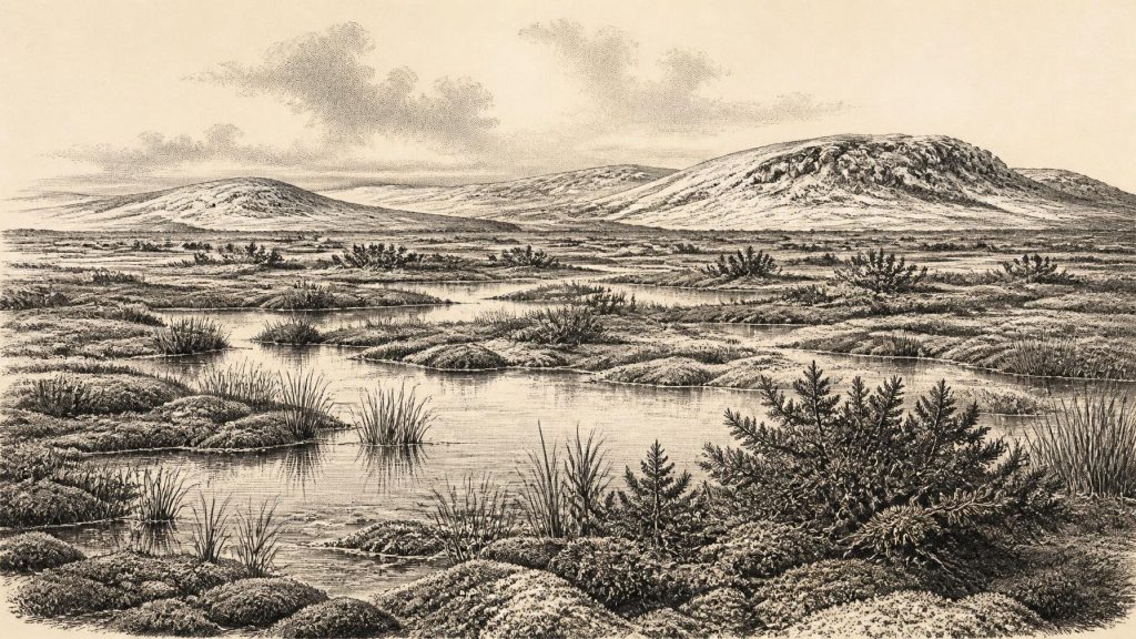
That range includes 31,530 BCE, but it must not be misused. It does not prove that a particular Derryvree pool, plant or animal existed in this exact numbered year. Nor does it establish that all Ireland shared the same conditions. It is a calibrated interval for dated organic matter in a deposit, not a stopwatch reading. The older terminology called the landscape a “muskeg”: a mosaic of saturated, mossy and sedge-rich ground, shallow pools and accumulating organic mud. In modern language, it was a cold periglacial wetland, shaped by severe seasonal freezing and thawing rather than by temperate woodland.
Wet Ground Beneath the Drumlin
The Derryvree fossils make this local landscape unusually vivid. Pollen, seeds, mosses and insect remains point to open tundra vegetation. Grasses and sedges were prominent; dwarf shrubs and herbs occupied exposed ground. Juniper is among the pollen recorded, while a fossil seed of bogbean, Menyanthes trifoliata, indicates freshwater or very wet ground. Mosses, plant-rich mud and open water provided habitats for specialised invertebrates. These are direct traces of an ecosystem, not merely a reconstruction inferred from the modern appearance of the drumlin country, whose rolling relief was itself later reshaped by ice.
The resulting terrain would have been treeless or nearly so, with low visibility broken by rises, pools, frozen ground and patches of vegetation rather than forests. It was not necessarily barren. Short growing seasons can still support productive wetland communities, especially where meltwater, springs or shallow basins keep water available. But productivity was seasonal and precarious. The evidence supports cold winters, repeated frost action and open vegetation; it does not supply precise temperatures, annual snowfall figures or a single island-wide weather pattern for 31,530 BCE.
Derryvree also demonstrates an important negative fact: local ice-free ground existed in north-central Ireland during part of this Middle Midlandian interval. That conclusion should not be inflated into a claim that the whole island was ice-free. Ireland’s Pleistocene record is fragmented, and later glaciers eroded or buried many deposits that might once have clarified regional differences. Comparable northern sequences at Aghnadarragh, near Lough Neagh, and Greenagho in Fermanagh show that the island’s cold-stage history involved alternating ice advances and ice-free episodes, not one uninterrupted blanket of ice.
Before the Greatest Advance
The nominal date predates the fullest known expansion of the last British–Irish Ice Sheet. Large-scale reconstructions show sustained ice-sheet growth from about 31,000 to 26,000 years BP, with maximum total ice volume around 23,000 years BP; individual sectors reached their greatest extent at different times. Thus 31,530 BCE belongs to a long prelude to the maximum, not to its climatic climax. The great ice mass that later scoured bedrock, excavated basins, rearranged drainage and deposited tills across Ireland had not yet imposed a single uniform landscape in every region represented by the surviving evidence.
Crag Cave in County Kerry supplies another, carefully qualified environmental clue. Uranium-series dating of cave calcite shows that speleothems grew episodically during warmer or less severely frozen intervals of the last glacial period. Because calcite deposition requires liquid water moving through the cave, these growth phases register shifts in local ground and cave conditions. They cannot describe Derryvree directly, nor can they date the target year precisely. Their value is broader: south-west Ireland, like the North Atlantic world around it, experienced pronounced climatic variability rather than permanent, unchanging cold.
Castlepook’s Animal Evidence
Far to the south, Castlepook Cave near Doneraile in County Cork is Ireland’s richest known archive of pre-Last Glacial Maximum cave fauna. Antiquarian excavations recovered many thousands of bones, although the original deposits were heavily disturbed and only a fraction of the collection is now accessible. Radiocarbon programmes and newer work have identified a striking assemblage including woolly mammoth, reindeer, giant deer, brown bear, wolf, fox, mountain hare, arctic lemming, Norwegian lemming and spotted hyaena. Different specimens belong to different episodes, so this is not a census of one moment or a single living community.
Nevertheless, the fauna establishes that cold-adapted mammals reached Ireland during the Late Pleistocene. Reindeer and mammoth evoke open grazing country, while lemmings and arctic fox fit a severe northern environment. Brown bears, wolves and hyaenas remind us that carcasses and caves were part of a food web involving predators, scavengers and denning animals. Cave bone accumulations must be read cautiously: a hyaena may carry prey remains into a chamber; water may move bones; excavation may mix layers. A bone in a cave is evidence that an animal, or part of one, entered the system, not proof that a cave was continuously occupied by every species represented there.
Recent sedimentary ancient-DNA research from Castlepook has added evidence for a wider biogeographical connection, detecting twelve ancient taxa and identifying Irish mammoth, hyaena and bear lineages related to populations elsewhere in Eurasia. As a preprint, this work remains subject to normal scholarly scrutiny, but its central implication accords with the fossil record: Late Pleistocene Irish animal populations were not wholly isolated. Lower sea levels and changing ice-free corridors periodically made movement around the north-west European margin possible. This was ecological connectivity, not evidence for trade, diplomacy or a settled political territory.
The Human Question
A reindeer femur from Castlepook has been reported as approximately 33,000 years old and as bearing a deep mark interpreted by researchers as a fresh-bone cut made with a sharp stone tool. If that interpretation is sustained, it may be Ireland’s earliest indication of human handling of an animal, potentially close in broad age to this article’s notional date. It would be a major discovery. But the limits are equally important. The age dates the bone, while the diagnosis of a tool mark is a separate taphonomic judgement; no associated stone toolkit, hearth, shelter floor, butchered assemblage or securely stratified camp is presently known from Ireland for this period.
Accordingly, it is not responsible to describe a named group of people living in Ireland in 31,530 BCE, still less to assign them a language, ethnicity or permanent homeland. The evidence may record a brief visit by one or a few Upper Palaeolithic people, or it may ultimately require a different explanation. Recent excavation reporting still describes Castlepook as lacking confirmed evidence of human occupation. Absence of a preserved camp does not demonstrate that nobody ever crossed this changing landscape; it does mean that sustained residence has not been archaeologically demonstrated.
Elsewhere in Europe, Upper Palaeolithic communities made sophisticated stone and organic tools, managed fire, processed large animals, travelled seasonally and maintained social ties across wide areas. Those comparisons help explain why a possible cut mark matters. They cannot fill Ireland’s silence with imported cave art, rituals, clans or technologies. No Irish evidence of this age identifies a leader, polity, conflict, alliance, shrine, burial, artwork or teaching tradition. There is likewise no basis for claims about organised trade. If people reached the island, their immediate economy would have depended on mobility, knowledge of terrain and access to food, fuel, hides and shelter; this is a reasonable inference from the cold environment, not a documented Irish institution.
An Unevenly Known Ireland
For society and everyday life, then, the strongest story is one of limits and possibilities. Derryvree records wetland plants and insects living between phases of ice; Castlepook records a diverse cold-stage fauna in a limestone cave system; ice-sheet and cave records show a geographically varied, changing northern Atlantic environment. They do not reveal villages, households or a population count. The apparent absence of such evidence owes much to later glacial erosion, changing shorelines, cave disturbance and the difficulty of finding very old sites, as well as to any real rarity of human visits.
Around 31,530 BCE, Ireland’s history is best understood as environmental history with a tentative human edge. Beneath the later drumlin at Derryvree, bogbean, sedges, mosses and freshwater sediments preserve a locally habitable tundra wetland. In the caves of Cork, the bones of grazing animals and carnivores preserve a broader cold-country fauna, perhaps accompanied once by people. The decisive political and cultural developments of later Irish history were still unimaginably far away. What survives here is more fundamental: evidence that life persisted, moved and adapted on an unstable Atlantic frontier before the greater advance of the ice.
Primary Sources
- A Middle Midlandian Freshwater Series at Derryvree, Maguiresbridge, County Fermanagh, Northern Ireland
- The Irish Quaternary Fauna Project
- The Exploration of Castlepook Cave, County Cork, Being the Third Report from the Committee Appointed to Explore Irish Caves
- Irish Pleistocene Biostratigraphy
- Figure 6.— The Subdivision of the Quaternary Period in Ireland
- Growth and Retreat of the Last British–Irish Ice Sheet, 31,000 to 15,000 Years Ago: The BRITICE-CHRONO Reconstruction
- BRITICE-CHRONO Maps and GIS Data of the Last British-Irish Ice Sheet 31 to 15 ka
- Reconstructing the Last Irish Ice Sheet 2: A Geomorphologically-Driven Model of Ice Sheet Growth, Retreat and Dynamics
- Trimlines, Blockfields and the Vertical Extent of the Last Ice Sheet in Southern Ireland
- Episodic Speleothem Deposition Tracks the Terrestrial Impact of Millennial-Scale Last Glacial Climate Variability in SW Ireland
- Freshwater Organic Deposits and Stratified Sediments Between Early and Late Midlandian (Devensian) Till Sheets, at Aghnadarragh, County Antrim, Northern Ireland
- Aghnadarragh: Earth Science Conservation Review Site Report
- New Insights on the Fauna of Ireland's Younger Dryas and Early Holocene from Alice & Gwendoline Cave
- Sedimentary Ancient DNA Reveals Late Pleistocene Faunal Connectivity Between Ireland and Eurasia
- Occurrence of Mammalia Relicts at Site Castlepook Cave
- 2022:564 – Castlepook Cave, Castlepook South, Cork
- Quaternary: Geological Survey Ireland
- NGRIP: GICC05 Time Scale and δ18O Values
- The Greenland Ice Core Chronology 2005, 15–42 ka. Part 1: Constructing the Time Scale
- The Mesolithic in Ireland: When Was It?
- Heritage Artefacts of County Cork
- Mammoth Cave, County Cork