

Fermanagh’s Intertill Tundra31061 BCE
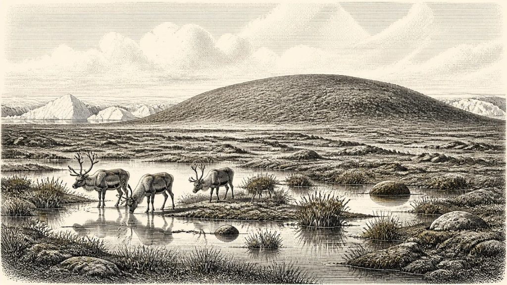
31,061 BCE is best understood as part of Marine Isotope Stage 3, not a recoverable Irish calendar year. At Derryvree, County Fermanagh, freshwater sediments and organic remains sealed between tills record a local ice-free interval, supporting treeless, tundra-like wetlands. Ireland’s landscapes varied sharply as the British–Irish Ice Sheet advanced and retreated; low sea levels did not guarantee a land bridge to Britain. Castlepook Cave, County Cork, preserves remains of mammoth, reindeer, giant deer and predators, demonstrating intermittent cold-climate fauna. A possibly stone-cut reindeer bone suggests early visitors, but no secure evidence establishes human settlement, society or island-wide conditions at once.
Dateline
31,061 BCE is a modern chronological label, not a year that can be recovered from Ireland’s archaeological record. It is approximately 33,010 years before AD 1950, the conventional “present” used in radiocarbon dating. No Irish community then used a calendar, left writing, named leaders, or produced a sequence capable of identifying a particular twelve-month span. The responsible frame is therefore the Late Pleistocene, during Marine Isotope Stage 3: a long, climatically unstable part of the last Ice Age, before the fullest extent of the Last Glacial Maximum.
The evidence is sparse, local and unevenly dated. It consists chiefly of buried freshwater sediments, glacial deposits, cave bones, and modern scientific analyses of them. It can illuminate environments and animal presence across broad spans of millennia. It cannot supply an event-by-event history of an Irish people, nor prove that all parts of the island shared one climate, landscape or human history at the same time.
A Date Within Broad Ranges
The most important Irish environmental sequence relevant to this period was exposed during road works in 1969 at Derryvree, near Maguiresbridge in County Fermanagh. The cutting passed through a drumlin and revealed silts and fine sands, including organic layers, trapped between two separate tills: unsorted sediments deposited by glacier ice. The stratigraphy is clear in its relative order. Ice had formed the lower till; an interval without ice at the locality allowed freshwater sediment and plant remains to accumulate; then a later ice advance laid down the upper till and sealed the earlier wetland.
Organic material from Derryvree produced the radiocarbon determination Birm-166, 30,500 radiocarbon years BP, with a substantial uncertainty of minus 1,030 and plus 1,170 years. Such a result cannot be read as a calendar date. Atmospheric radiocarbon changed through time, so results require calibration against independently dated records such as IntCal20; at this age, both the laboratory error and the form of the calibration curve produce wide calendar ranges. In broad terms, the Derryvree deposits belong to the middle-to-later part of the last Ice Age, around the mid-30,000s calibrated years before present. The label 31,061 BCE may fall near the chronological horizon under discussion, but it cannot be assigned to a particular sediment layer, season or episode at Derryvree.
This distinction matters. Derryvree is not evidence that the whole of Ireland was ice-free, nor that an open wetland persisted unchanged for thousands of years. It is powerful evidence that this part of Fermanagh experienced a non-glacial interval between episodes of ice cover. The wider island was a moving mosaic of ice, periglacial ground, water, exposed rock and habitat, changing as the British–Irish Ice Sheet grew and shifted.
Wetland Beneath the Drumlin
The Derryvree flora and fauna indicate a treeless, cold, periglacial landscape. The freshwater deposits contained remains of mosses and plants suited to open, wet ground, including sedges and aquatic or marsh vegetation. Rather than imagining modern blanket bog or green pasture, it is better to picture shallow pools, saturated silts, sedge-rich margins and open tundra-like ground, with vegetation low to the surface and exposed to severe seasonal conditions. The older term “muskeg”, used in descriptions of the deposit, conveys a waterlogged, mossy, cold-climate wetland rather than a forested landscape.
That evidence is especially valuable because glaciation later destroyed, buried or reworked much of the earlier land surface. Pollen grains, plant macrofossils and small animal remains are therefore not minor details: they are among the few direct witnesses to an Irish ecosystem before the Last Glacial Maximum. They show that life could occupy local refuges between glacial advances, even where no human settlement is known.
The climate was not simply a single unbroken “Ice Age winter”. Marine Isotope Stage 3 contained abrupt climatic oscillations recorded particularly well in Greenland ice cores and North Atlantic archives. Ireland lay at the Atlantic edge of north-west Europe, where changes in temperature, sea ice, precipitation and ocean circulation could alter ice margins and habitats rapidly in geological terms. Yet the available Irish sequences do not permit those wider fluctuations to be matched confidently to one notional calendar year at Derryvree.
Ice, Sea and a Changing Island
At this time Ireland’s geography was shaped as much by ice and sea level as by land. Global sea levels were far lower than today because water was stored in continental ice sheets, but low sea level did not automatically create a reliable dry-land route from Ireland to Britain. Geological research has challenged the older assumption of a broad Irish land bridge. The Irish Sea basin, changing relative sea level, islands, glaciers and sea ice created more complicated possibilities. For this period, neither a simple land bridge nor an easy crossing should be assumed.
Evidence from western Ireland shows that the Irish Ice Sheet was already substantial and dynamic before the later maximum. Marine and glacial deposits indicate major ice-sheet loading and fluctuations on the continental shelf over a long interval before the Last Glacial Maximum. Other reconstructions place the greatest late-glacial expansion of the British–Irish Ice Sheet later, broadly after 27,000 years ago and with major maximum positions in the 26,000–20,000-years-ago range, depending on sector and method. Thus 31,061 BCE belongs to an iceward world, but not to a neat island-wide moment when every valley and coast can be classified as either frozen or free of ice.
This regional variation is central to understanding settlement potential. An ice-free patch of wetland could support plants and animals, while nearby terrain might be dominated by glacier ice, meltwater or bare, frost-shattered ground. The archaeological record is correspondingly selective: caves preserve bones in the south, intertill sediments preserve plants in Fermanagh, and offshore deposits preserve parts of an ice-sheet history now beyond the modern coast.
Castlepook’s Animal World
Castlepook Cave, also known as Mammoth Cave, near Doneraile in north County Cork, provides the most striking animal evidence for the broader period. Its chambers have yielded remains of woolly mammoth, reindeer, giant deer, brown bear, wolf, Arctic fox, lemmings and spotted hyaena. The cave lies in the Awbeg Valley below the Ballyhoura Hills, and its faunal collection is among Ireland’s richest records of Pleistocene vertebrates.
Radiocarbon work on the cave assemblage has produced pre-Last Glacial Maximum dates for different animals. Examples include mammoth dated to 34,100 ± 840 radiocarbon years BP, reindeer to 35,200 ± 950 BP, giant deer to 32,060 ± 630 BP, and brown bear to 33,310 ± 770 BP. These are not evidence that every species stood together at Castlepook in a single generation. Cave deposits often mix material from distinct episodes, while many of the earliest excavations removed bones before modern recording standards existed. The most defensible conclusion is that cold-adapted and open-country animals reached Ireland intermittently during this general Late Pleistocene interval.
Predators are important evidence in their own right. Spotted hyaena remains and carnivore damage on bone show that caves were part of animal landscapes, not automatically human homes. A cave may have been a den, a trap, a shelter, a place where water and sediment accumulated, or a location into which bones were dragged. The animal record conveys a food web: large herbivores feeding in open habitats, carnivores scavenging or hunting them, and smaller cold-adapted mammals occupying the same wider environmental zone.
The Human Question
A reindeer femur from Castlepook has been reported as about 33,000 years old and as bearing a mark interpreted by zooarchaeologist Ruth Carden as damage made by a sharp stone tool during carcass processing. If that interpretation is upheld, it would be Ireland’s earliest currently proposed sign of human activity, far earlier than the island’s securely documented Mesolithic settlement. It raises the possibility that Upper Palaeolithic people reached Ireland briefly during a favourable window.
But “possible human activity” is not the same as an established settlement. The femur comes from a historically excavated cave collection rather than a recently excavated, tightly controlled occupation layer. No securely associated hearth, tool assemblage, dwelling floor, burial, repeated campsite or contemporaneous group of butchered animals has yet been demonstrated for Ireland at this date. The mark may be significant, but it cannot identify the number of visitors, their route, language, ancestry, season of arrival or length of stay. It certainly cannot support claims of a resident population spread across the island.
For the same reason, there is no responsible evidence for political affairs, diplomacy, warfare, named communities, religious observance, formal trade or artistic traditions in Ireland in 31,061 BCE. No houses, monuments, pottery, metalwork, textiles, carvings or written marks are known from an Irish human community of this age. Continental Europe had Upper Palaeolithic societies with varied technologies, exchange networks and forms of symbolic expression, but these cannot be transferred automatically across the sea to Ireland.
What Can Be Said of Everyday Life
If people did visit, their practical concerns would have been immediate: moving through a dangerous cold landscape, locating fresh water and shelter, using fire and portable equipment, and obtaining animal food where opportunity allowed. Reindeer would have been a valuable source of meat, hide, sinew and bone; the Castlepook femur, if genuinely butchered by people, would preserve only one small act within such a task. That is an interpretation from comparative Upper Palaeolithic archaeology, not a direct reconstruction of a known Irish camp.
The more secure story is environmental. Around the broad period represented by 31,061 BCE, Ireland was not the later wooded island of farming communities, kingdoms and monasteries. It was a fluctuating Pleistocene landscape on the Atlantic fringe, repeatedly remade by ice. Fermanagh’s buried freshwater sediments demonstrate local wetland life between glacial episodes. Cork’s caves demonstrate that a varied cold-climate fauna reached the island. Castlepook’s marked reindeer bone poses, but does not settle, the question of early human visitors. The gaps in that story are not failures of imagination; they are the essential historical fact.
Primary Sources
- A Middle Midlandian Freshwater Series at Derryvree, Maguiresbridge, County Fermanagh, Northern Ireland
- A Middle Midlandian Freshwater Series at Derryvree, Maguiresbridge, County Fermanagh, Northern Ireland
- Quaternary Research in Ireland: Field Guide 17
- Growth and Retreat of the Last British–Irish Ice Sheet, 31,000 to 15,000 Years Ago: The BRITICE-CHRONO Reconstruction
- Growth and Retreat of the Last British–Irish Ice Sheet, 31,000 to 15,000 Years Ago: The BRITICE-CHRONO Reconstruction
- Radiocarbon Constraints on the History of the Western Irish Ice Sheet Prior to the Last Glacial Maximum
- Maximum Extent and Dynamic Behaviour of the Last British–Irish Ice Sheet West of Ireland
- Dimensions and Chronology of the Last Ice Sheet in Western Ireland
- Trimlines, Blockfields and the Vertical Extent of the Last Ice Sheet in Southern Ireland
- The Irish Quaternary Fauna Project
- Pleistocene Vertebrates in the British Isles
- Areas of Scientific Interest in County Cork: Castlepook Caves
- Heritage Artefacts of County Cork
- The Mammoth Caves of Castlepook, Near Doneraile
- 32564: Castlepook Cave, Castlepook, Cork
- The IntCal20 Northern Hemisphere Radiocarbon Age Calibration Curve (0–55 cal kBP)
- The IntCal20 Northern Hemisphere Radiocarbon Age Calibration Curve (0–55 cal kBP)
- The Problem of a Late Quaternary Landbridge Between Britain and Ireland
- The Island of Ireland: Drowning the Myth of an Irish Land-bridge?
- The Mesolithic in Ireland: When Was It?