

Derryvree’s Intertill Record30860 BCE
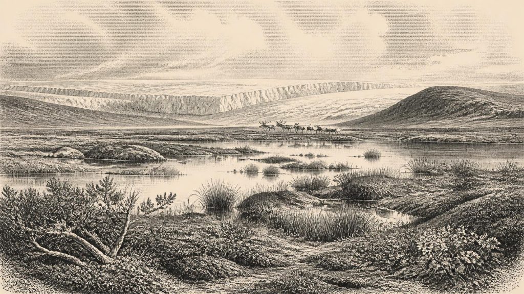
30,860 BCE is a notional modern label within MIS 3, rather than a precisely recoverable date. Derryvree’s freshwater sediments, deposited between glacial tills in County Fermanagh, date broadly to 36,900–31,700 cal BP and demonstrate that north-central Ireland was locally ice-free during part of this unstable interval. Their plants indicate cold, open wetlands with shallow water, sedges and tundra-like vegetation. Cave assemblages elsewhere record varied fauna, including reindeer, giant deer and mammoth, but do not prove contemporaneous local communities. No securely dated archaeological evidence establishes human presence at this time. Lower sea levels altered access, yet no certain land bridge existed.
Dateline
“30,860 BCE” is a modern calendar label, not a date that can be recovered with year-by-year precision from Ireland’s Ice Age record. No person, settlement, object or event can responsibly be assigned to that exact year. The most useful way to approach it is as a point within the later part of Marine Isotope Stage 3, a climatically unstable phase of the Pleistocene before the fullest expansion of the last British–Irish Ice Sheet. Calibrated radiocarbon evidence from a freshwater deposit at Derryvree, near Maguiresbridge in County Fermanagh, spans broadly c. 36,900–31,700 cal BP: approximately 34,950–29,750 BCE. The notional year falls within that broad range, but it does not date every layer of sediment, every animal or every part of Ireland.
A Landscape Recorded Indirectly
For this remote period, Ireland’s history is principally environmental history. The archive consists not of chronicles, houses, graves or named communities, but of silts, sands, pollen, plant fragments, animal bones, cave deposits and the landforms created or altered by ice. Later glaciers erased, reworked or buried much of the earlier evidence. The absence of an archaeological site is therefore not proof that no human being ever entered Ireland; it is, however, decisive against writing a story of an identifiable population, camp or culture here in 30,860 BCE. There is no securely dated lithic assemblage, hearth, human bone, dwelling, artwork or burial that demonstrates a human presence in Ireland at this time.
This distinction matters. Ireland had a rich Pleistocene animal history, and its position on the north-western edge of Europe made occasional incursions by animals—and conceivably people—possible during favourable intervals. Yet a faunal record is not a settlement record. The strongest present evidence for a human visit to Ireland belongs much later, in the terminal Palaeolithic: a cut-marked brown-bear patella from Alice and Gwendoline Cave, County Clare, dated to roughly 12,810–12,590 cal BP. Sustained and unequivocal colonisation is later still, in the Mesolithic. Nothing comparable anchors people in Ireland around 30,860 BCE.
Freshwater Between Ice Sheets
Derryvree is exceptionally important because a road cutting through a drumlin exposed fine freshwater sediments lying between two thick tills. Till is unsorted material deposited by glacial ice. The sequence therefore preserves a simple but powerful order of events: ice had covered the locality; then, for a time, open water and sediment accumulated; later, ice returned or advanced across the site. Organic material from the freshwater bed produced the radiocarbon determination known as BIRM-166. Its calibrated range, c. 36.9–31.7 thousand years before present, places the deposit within MIS 3 and shows that north-central Ireland was locally ice-free during at least part of that interval.
That conclusion must not be enlarged beyond the evidence. Derryvree does not show that all Ireland was free of ice in every year of the range, nor does it supply a weather report for 30,860 BCE. The deposit represents an interval of deposition at one place. Nevertheless, it is a crucial check on older, over-simple pictures of an island continuously entombed beneath ice until the Last Glacial Maximum. The last ice sheet developed through advances, reorganisations and regional differences. By the later part of MIS 3, its growth was under way, but the timing of extensive ice cover differed between Irish regions and remains the subject of continuing refinement through radiocarbon dating, exposure dating, offshore records and ice-sheet modelling.
Cold Wetlands, Not Forest
The Derryvree sediments contain a botanical assemblage suited to cold, open and wet ground. Mosses, sedges and aquatic or waterside plants, including bogbean (Menyanthes trifoliata), point to pools, marshy margins and shallow freshwater rather than to a closed woodland landscape. Other fossil plants in the wider assemblage include taxa associated with tundra or Arctic-alpine conditions, such as dwarf willow and mountain avens. The landscape was therefore likely treeless or only very sparsely wooded in the immediate region, exposed to a severe continental climate and shaped by frost, seasonal thaw and changing water levels.
It should not be imagined as a featureless white waste. Even a cold, largely open terrain could contain sheltered hollows, wet basins, sedge beds, patches of dwarf shrubs and productive shallow waters. Such places could concentrate plant growth and attract grazing animals. Yet this was no stable pastoral landscape. The same stratigraphy records climatic and glacial change on a scale far beyond any human control. A wetland capable of supporting aquatic plants could be overwhelmed, buried and preserved beneath a subsequent ice advance. The future drumlin country of Fermanagh was being made, destroyed and remade by those processes.
Animals at the Atlantic Edge
Irish cave deposits give a complementary, though geographically separate, view of MIS 3 life. Castlepook Cave near Doneraile in north Cork has yielded an important Late Pleistocene fauna that includes reindeer, giant deer, brown bear, wolf, fox, hare, lemming, mammoth and spotted hyaena. Not every species need have shared the cave or landscape at one moment, and individual dates require careful treatment. Modern re-dating has shown that some older radiocarbon results from Irish caves were substantially too young, moving parts of the Castlepook assemblage deeper into MIS 3. The responsible conclusion is that southern Ireland supported a varied cold-stage fauna over a long period, not that a complete list of animals stood together beside a Fermanagh pool in 30,860 BCE.
Reindeer are especially evocative because they fit an open, cold landscape and because their remains have prompted long-running discussion of possible human activity. A reindeer femur from Castlepook has a deep linear mark that has been interpreted as a possible fresh-bone cut or chop made by a stone implement. It is an intriguing claim, but one isolated modified bone is not evidence for a settlement, and its chronology cannot establish an event in the named modern year. Cave deposits are also shaped by carnivores, scavengers, water movement, excavation history and later disturbance. The scientific value of the find lies partly in keeping the question open while resisting the temptation to turn possibility into a populated Irish Palaeolithic.
Sea, Land and Movement
Global sea level was much lower during the last glacial cycle than it is today, exposing large areas of continental shelf around Ireland and Britain. Coastlines were consequently far beyond their modern positions in some areas, and the shape of the Irish Sea basin differed greatly from the familiar map. Lower sea level did not automatically create a simple, dry land bridge to Ireland, however. Whether people or animals could move depended on shifting water barriers, ice margins, local topography, weather, available food and the ability to travel across difficult terrain or water. At this date, movement into Ireland is best treated as a geographic possibility rather than a demonstrated migration.
The environmental evidence does show that Ireland was connected to the wider north-west European world in ecological terms. Mammals had reached the island during Pleistocene intervals, while glacial ice and sea repeatedly rearranged access, habitat and survival. But no evidence identifies trade, exchange partnerships or regular communication. There were no political affairs, diplomacy or warfare that archaeology can responsibly describe for Ireland in this year. Nor is there evidence for a local economy in the social sense: no known hunting camp, processing area, tool industry or store of food can be tied to it. The relevant economy was ecological—the seasonal movement of animals and the survival of plants in a cold, changing landscape.
Culture Beyond Recovery
Religion, language, learning and artistic culture cannot be reconstructed for Ireland around 30,860 BCE. It would be misleading to fill that silence with analogies from contemporary Upper Palaeolithic societies elsewhere in Europe. People on the continent made sophisticated stone and organic tools, travelled widely and, in some regions, created art and ornament; none of this proves an equivalent practice on the island. Equally, it would be wrong to infer cultural emptiness from the lack of Irish finds. The record has been heavily filtered by later glaciation, rising seas and the uneven survival of materials. What survives permits a guarded account of habitats and animals, not a biography of an Irish community.
At this point in deep time, the principal historical development was environmental instability. Derryvree’s freshwater bed captures a relatively brief phase when cold wetland life persisted between glacial episodes. Castlepook and other caves preserve fragments of a broader animal world that later climatic deterioration transformed. In the millennia after the dated interval, the British–Irish Ice Sheet expanded towards its maximum extent, covering or severely affecting most of Ireland and further diminishing the chances that pre-existing traces of people would survive. The story attached to 30,860 BCE is therefore not of chiefs, battles or monuments. It is of a precarious ice-age landscape, known through its sediments, and of the limits that its evidence places on responsible historical imagination.
Primary Sources
- A Middle Midlandian Freshwater Series at Derryvree, Maguiresbridge, County Fermanagh, Northern Ireland
- Trimlines, blockfields and the vertical extent of the last ice sheet in southern Ireland
- A reconsideration of the radiocarbon dating of the Marine Isotope Stage 3 fauna from southern Ireland
- The Irish quaternary fauna project
- First evidence of a Late Upper Palaeolithic human presence in Ireland
- New insights on the fauna of Ireland's Younger Dryas and Early Holocene from Alice & Gwendoline Cave
- Ireland: Submerged Prehistoric Sites and Landscapes
- BRITICE Glacial Map, version 2: a map and GIS database of glacial landforms of the last British–Irish Ice Sheet
- Exploring controls of the early and stepped deglaciation on the western margin of the British Irish Ice Sheet
- Dynamic cycles, ice streams and their impact on the extent, chronology and deglaciation of the British-Irish ice sheet
- Late Pleistocene sediments, landforms and events in Scotland: a review of the terrestrial stratigraphic record
- Middle Midlandian Interstadial Deposits at Greenagho, Near Belcoo, County Fermanagh, Northern Ireland
- Freshwater organic deposits and stratified sediments between early and late Midlandian (Devensian) till sheets, at Aghnadarragh, County Antrim, Northern Ireland
- Geology of Ireland
- Quaternary Geomorphology Map Service
- An All-Ireland Quaternary Map
- Outreach and Education Resources
- Field Guides
- 2019:148 – Alice & Gwendoline Cave, Clare
- The colonization of Ireland: A human ecology perspective