Derryvree’s Intertill World30436 BCE
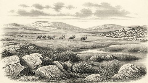
Around 30,436 BCE, Ireland lay within the fluctuating Late Pleistocene climate of Marine Isotope Stage 3, not a date capable of supporting a historical narrative. At Derryvree, County Fermanagh, freshwater silts between glacial tills, broadly dated to this interval, preserve sedges, mosses, dwarf shrubs and aquatic plants, indicating cold, treeless wetlands and open tundra. Castlepook Cave, County Cork, contains time-averaged remains of mammoth, giant deer, reindeer, predators and other cold-adapted fauna. Crag Cave records alternating warmer and colder phases. Advancing ice later reshaped and obscured landscapes. No secure evidence directly establishes human settlement or activity in Ireland at this date.

Dateline
The label 30,436 BCE is a modern point on a deep-time scale, not a recoverable Irish calendar year. No written record, named community, settlement, political unit or individual action can be assigned to it. Even the closest scientific evidence consists of deposits formed over long intervals and dated with substantial uncertainty. The responsible question is therefore not “what happened in Ireland that year?” but what the surviving archaeological and environmental evidence can illuminate about Ireland in the broad period into which it falls.
That period belongs to the Late Pleistocene, during Marine Isotope Stage 3, an unstable portion of the last Ice Age. Ireland’s climate, ice cover, coastlines and animal habitats changed repeatedly on scales of centuries and millennia. A calendar conversion of this date places it roughly 32,386 years before AD 1950, the conventional reference point for radiocarbon dating. That is close to, but not identical with, a radiocarbon age. At this depth in time, calibrated ranges are more meaningful than a single year.
A Freshwater Interval at Derryvree
The most illuminating Irish evidence is the Derryvree sequence near Maguiresbridge, County Fermanagh. Roadworks in 1969 exposed a section through a drumlin: beneath a thick upper layer of glacial till lay organic freshwater silts and fine sands, and beneath those lay another till. The order matters. Till is debris laid down by glacier ice; the organic beds between the two tills accumulated during a period when the site was not overridden by ice and shallow freshwater conditions existed.
Eric Colhoun, J. H. Dickson, A. M. McCabe and F. W. Shotton’s investigation recovered a conventional radiocarbon determination, BIRM-166, of 30,500 radiocarbon years before present, with a wide uncertainty. Published calibrations have placed the deposit broadly around 36,900–31,700 calibrated years before present, approximately 34,950–29,750 BCE. The modern marker 30,436 BCE falls within that broad span. It cannot, however, date one pond edge, one season, or one year within the life of the deposit. Nor should the range be treated as permanently fixed: calibration curves and assessments of older measurements are refined as research progresses.
The direct evidence is nevertheless remarkable. Derryvree shows that part of north-central Ireland supported freshwater sedimentation, wet ground and plant life before a later glacier crossed the locality. It is evidence for an ice-free or ice-marginal landscape at that place during a long Late Pleistocene interval. It is not proof that all Ireland was simultaneously free of ice, nor a precise map of the island’s conditions in 30,436 BCE.
Pool, Marsh and Open Ground
The organic silts preserved an ecological assemblage rather than an ancient scene frozen in a moment. Plant macrofossils and pollen included sedges, mosses, dwarf willow, juniper, mountain avens, water-milfoil and bogbean. These remains point to a treeless, cold-climate mosaic: damp mossy ground, shallow open water, sedge-rich margins and patches of low tundra vegetation. Insects added important detail. Their presence supported an interpretation of muskeg-like wetland with plant-rich pools, not merely barren gravel beside an ice front.
This was no modern Irish bog. Trees did not form a woodland canopy around Derryvree, and the flora contained species now associated chiefly with much colder or more alpine environments. Yet the evidence also cautions against imagining a uniformly lifeless snow desert. Summer growing seasons, however short, sustained rooted plants, aquatic vegetation and invertebrates. Freshwater was available locally. The landscape was environmentally demanding but biologically active.
Such a reconstruction is an interpretation built upon the fossils and their ecological requirements. The evidence directly establishes particular remains in particular sedimentary layers. It does not reveal the exact vegetation cover of the whole island, annual snowfall, or the appearance of every hillside. The layered deposits instead give a local, time-averaged window into a changing periglacial world.
Animals Beyond the Wetland
Other sites broaden the picture, especially Castlepook Cave near Doneraile in County Cork. This limestone cave is Ireland’s richest known repository of vertebrate remains dating to the long period before and during the Last Glacial Maximum. Its collections include woolly mammoth, giant deer, reindeer, brown bear and spotted hyaena, alongside wolf, Arctic fox, mountain hare and two lemming species. These animals demonstrate that Ireland was repeatedly accessible to, and capable of supporting, a cold-adapted large-mammal fauna.
Castlepook must not be read as a census for 30,436 BCE. The cave accumulated bones across many thousands of years, and water movement, carnivore activity and earlier excavation have disturbed parts of the deposit. Individual bone dates span a long range, from roughly 45,700 to 19,950 years before present. A cave used or visited by hyaenas is particularly selective: bones may have arrived as prey remains, scavenged carcasses, natural deaths or material moved by water. The assemblage is compelling evidence of an Ice Age fauna in Ireland, but not a list of animals standing together on one day.
Combined with Derryvree, it supports a cautious regional inference. Cold, open habitats could provide grazing and browsing for reindeer, giant deer and mammoth, while supporting predators and scavengers. Their movements would have followed changing food, shelter, snow conditions and routes between Ireland, Britain and the exposed lands and shallow seas of north-west Europe. Lower sea levels altered the geography considerably, but there was no simple, permanent land bridge joining Ireland and Britain. Connections were variable, and the coastline familiar today did not exist.
Ice Was Advancing
The Derryvree wetland existed before the last major expansion of the British–Irish Ice Sheet erased or buried much evidence across the island. Modern reconstructions show that this ice sheet grew asynchronously: different sectors advanced, reached maximum extent and later retreated at different times. The greatest total ice volume was reached much later, around 23,000 years ago, but ice growth was already becoming a decisive force in the millennia after the Derryvree interval.
Crag Cave in County Kerry provides a complementary, though indirect, record of this climatic instability. Uranium-thorium dating of cave mineral deposits indicates that speleothems formed episodically during warmer phases of Marine Isotope Stage 3, when liquid water could infiltrate the cave and soils were active. Their interruptions indicate renewed cold severe enough to halt this process. Together, Crag Cave and Derryvree show that Ireland’s Ice Age was punctuated, not a single unchanging freeze.
Regional change therefore dominated the history of this era. Glaciers could advance over lowlands; meltwater could reshape drainage; sea level could transform coastal approaches; and open ground could contract or expand. Later ice movement both created many of Ireland’s familiar glacial landforms and destroyed, displaced or deeply buried the fragile traces of earlier landscapes. The scarcity of Palaeolithic sites is consequently an archaeological fact, but also a preservation problem.
People: A Necessary Restraint
There is no securely excavated settlement, hearth, stone-tool assemblage, burial or domestic structure in Ireland that can be assigned to 30,436 BCE. There can be no responsible account of Irish government, diplomacy, warfare, religion, learning, trade or daily household life for this date. These are not simply missing chapters awaiting narrative reconstruction; the evidence needed to write them has not been found.
Castlepook has prompted discussion because one reindeer femur in the old collection bears an incision interpreted by some researchers as a stone-tool cut mark, and the bone has been presented as possible evidence of very early human handling of an animal. That possibility deserves investigation, but it remains insufficient for claims of a settled population, a hunting camp, or a society in Ireland at this exact time. The cave’s complex depositional history and the need for full publication and critical review require caution. Recent work elsewhere, at Alice and Gwendoline Cave in County Clare, has produced stronger evidence for human presence only much later, in the terminal Pleistocene.
Hunter-gatherers lived in north-west Europe during this broad era, with sophisticated stone technologies, social networks and cultural practices documented beyond Ireland. Those European comparisons show what was possible, not what has been demonstrated on the island. It would be unsound to project continental art, kinship, ritual or economic arrangements onto Derryvree’s wetlands without Irish material evidence.
An Environmental History
For Ireland around 30,436 BCE, environment is the history that can be told most securely. A Fermanagh freshwater deposit records low tundra plants, mosses, sedges and pools between episodes of glaciation. A Cork cave preserves the time-averaged remains of a striking Ice Age fauna. A Kerry cave records climatic oscillation through the presence and absence of mineral growth. These archives disclose a dynamic island on the edge of profound glacial transformation.
Their lesson is not that Ireland was empty or eventless, but that the evidence operates at a different scale from later history. The surviving record cannot supply a year-by-year chronicle. It can, however, recover a world of cold water, open ground, mobile animals and approaching ice: a vulnerable, varied Irish landscape that existed long before the familiar human history of settlement, farming, kingdoms and written memory.
Primary Sources
- A Middle Midlandian Freshwater Series at Derryvree, Maguiresbridge, County Fermanagh, Northern Ireland
- Growth and Retreat of the Last British–Irish Ice Sheet, 31 000 to 15 000 Years Ago: the BRITICE-CHRONO Reconstruction
- The Timing and Magnitude of the British–Irish Ice Sheet Between Marine Isotope Stages 5d and 2
- Radiocarbon Constraints on the Age of the Maximum Advance of the British–Irish Ice Sheet in the Celtic Sea
- New Data for the Last Glacial Maximum in Great Britain and Ireland
- Pattern and Timing of Retreat of the Last British-Irish Ice Sheet
- Maximum Extent and Readvance Dynamics of the Irish Sea Ice Stream and Irish Sea Glacier Since the Last Glacial Maximum
- Castlepook Cave
- The Irish Quaternary Fauna Project
- Occurrence of Mammalia Relicts at Site Castlepook Cave
- New Insights on the Fauna of Ireland's Younger Dryas and Early Holocene from Alice & Gwendoline Cave
- Episodic Speleothem Deposition Tracks the Terrestrial Impact of Millennial-Scale Last Glacial Climate Variability in SW Ireland
- Ireland: Submerged Prehistoric Sites and Landscapes
- Ireland's Palaeolithic Archaeology – Fleeting Footprints in a Frozen Land
- Archaeology Research Excavation Grant 2022: Final Report
- The IntCal20 Northern Hemisphere Radiocarbon Age Calibration Curve (0–55 cal kBP)
- IntCal Publications
- Quaternary
- Introduction to the Late Quaternary and Holocene of Northern Ireland
- The Irish Quaternary Fauna Project
- Sedimentary Ancient DNA Reveals Late Pleistocene Faunal Connectivity Between Ireland and Eurasia