
Maguirebridge’s Periglacial Waters30530 BCE
30,530 BCE, Ireland lay within the unstable Marine Isotope Stage 3, before expansion of the British–Irish Ice Sheet. At Derryvree near Maguiresbridge, Fermanagh, silts, sands and sediments between glacial tills preserve secure evidence of wet tundra, pools, cold-tolerant plants and animals. These deposits indicate seasonal periglacial habitats later overwhelmed by advancing ice. Castlepook Cave, County Cork, records cold-stage fauna and possibly human butchery: a marked reindeer bone may show tool use around 33,000 years ago. However, disturbed deposits and absent associated artefacts prevent proof of occupation. Evidence supports environmental reconstruction and brief human visits, not recoverable society or precise dating.
Dateline
The label 30,530 BCE is a modern way of marking a point deep in the Late Pleistocene, not a year that anyone in Ireland could have named or recorded. There was no calendar, writing, polity or historical chronicle from which a year-specific Irish event can be recovered. In archaeological terms, the date is best treated as approximately 32,480 calendar years before present, using 1950 as the conventional “present”. Even that conversion should not suggest false precision: radiocarbon results carry uncertainties, and calibration produces ranges rather than single dates.
The closest important Irish environmental archive is at Derryvree, near Maguiresbridge in County Fermanagh. Organic silts and fine sands found beneath later glacial deposits there produced the conventional radiocarbon determination BIRM-166: 30,500 radiocarbon years BP, with a substantial error margin. Modern calibration places that evidence broadly within about 31,700–36,900 calibrated years BP. Thus 30,530 BCE falls securely within the broad world represented by Derryvree, but cannot be equated with one layer, one season or one occurrence at the site.
A Wetland Beneath the Drumlins
Derryvree was exposed during roadworks in 1969, where a cut through a drumlin revealed a freshwater sequence trapped between two thick tills, sediments laid down by ice. This arrangement is the key to its importance. The lower till records an earlier glacial episode; above it lay silts, sands and organic material accumulating when water, vegetation and animals occupied the locality; the upper till shows that ice later returned and buried the wetland. The deposit is therefore not a snapshot of an untouched landscape. It is a small, exceptionally valuable survival from an interval between advances of ice.
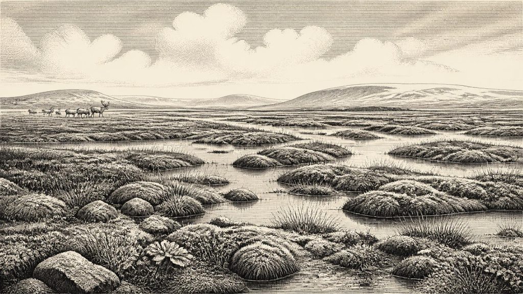
Plant and animal remains from the organic layers indicated a cold, open environment. The original investigators described a full-glacial flora and fauna, while later Irish Quaternary syntheses characterise the setting as treeless muskeg or wet tundra under a periglacial climate. In practical terms, this was a terrain shaped by frost, saturated ground, shallow pools and seasonal thaw rather than by woodland. Sedges, mosses and cold-tolerant herbs could establish around water; small aquatic plants indicate freshwater conditions. Such evidence allows a responsible reconstruction of local habitats, not a detailed map of every valley in Ireland.
At around this date, the Fermanagh landscape was therefore capable of supporting wetland life despite severe cold. Summers may have briefly released the surface soils and margins of pools, while winter frost repeatedly altered the ground. Treelessness need not mean barrenness. Arctic and alpine plant communities can be biologically varied, and wetlands concentrate food and shelter for insects, birds and mammals. Yet productivity was strongly seasonal and exposure to wind, frost and snow would have been defining constraints.
Before the Maximum Ice Expansion
This was Marine Isotope Stage 3, a long and climatically unstable portion of the last Ice Age. Greenland ice-core records show abrupt oscillations between colder stadials and relatively milder interstadials across this period. Irish evidence cannot be matched confidently to a single short-lived Greenland event, but the Derryvree date range overlaps several such oscillations. Deposits in Crag Cave, County Kerry, add a second line of evidence: speleothems grew episodically during milder last-glacial intervals, because dripping water and unfrozen ground were necessary for calcite formation. Together, Fermanagh wetland sediments and Kerry cave mineral deposits show that Ireland’s climate changed markedly through time rather than remaining uniformly frozen.
Nevertheless, the island was moving towards a far harsher phase. The greatest extent of the last British–Irish Ice Sheet came later, broadly around 27,000 calibrated years BP for the local ice-sheet maximum, while the global Last Glacial Maximum lasted roughly 26,500–19,000 years BP. At 30,530 BCE, the full maximum had not yet arrived, but the preservation of Derryvree between tills makes the larger trajectory unmistakable: habitable wetland conditions were eventually overtaken by expanding ice.
That later glaciation also explains much of the difficulty of Ireland’s earlier prehistory. Advancing ice eroded land surfaces, rearranged sediments and sealed or destroyed potential archaeological sites. The familiar drumlin country of Fermanagh is itself part of the legacy of such processes. Archaeologists therefore work with discontinuous evidence: a buried wetland here, a cave-bone assemblage there, and broad landforms across the country. Absence of a camp or tool scatter cannot simply be read as proof that no person ever passed through.
Castlepook and the Human Question
The most striking possible human evidence for this broad period comes from Castlepook Cave, also called Mammoth Cave, near Doneraile in north County Cork. The cave produced an unusually rich but complicated collection of Pleistocene animal remains, many recovered during early twentieth-century excavations whose recording standards were far below those expected today. Radiocarbon work associated reindeer, mammoth, giant deer, brown bear, wolf, spotted hyaena, Arctic fox and small cold-adapted mammals with different episodes in the cave’s long history. Their remains demonstrate that southern Ireland was intermittently accessible to a varied cold-stage fauna.
A reindeer femur from the Castlepook collection has been reported as approximately 33,000 years old and bears a deep linear mark interpreted by zooarchaeologist Ruth Carden as damage made by a sharp stone tool during carcass processing. If that assessment is correct, it is evidence that a person used a tool on a reindeer carcass in Ireland during the Upper Palaeolithic, vastly earlier than the island’s well-established post-glacial settlement record. County Cork heritage material places the object broadly around 31,000 BCE, sufficiently close to the present nominal date to make it essential context.
The limits of this evidence are as important as its promise. One marked bone does not identify the tool’s form, the language or identity of its user, the size of a party, a permanent settlement, or a continuous population. No securely associated hearth, shelter, stone-tool assemblage, burial, ornament or art has yet been recovered from this horizon in Ireland. Cave deposits are especially difficult to interpret: carnivores can transport and gnaw bones, water can move sediments, and early excavations may combine materials from separate layers. A cautious conclusion is that short-lived human activity is possible, perhaps even likely if the cut-mark interpretation stands, but sustained occupation remains unproven.
Life, Movement and Resources
If people did reach Ireland in this period, they would have entered an environment familiar in broad outline to Upper Palaeolithic hunter-gatherers elsewhere in north-west Europe: open ground, large herbivores, predators, sharp seasonal contrasts and rapidly shifting climatic opportunities. Reindeer would have offered meat, fat, hide, sinew, antler and bone. Mammoth and giant deer remains underline the presence, at least at differing times, of larger animals. But this is an inference from regional comparison and animal evidence, not a description of a documented Irish hunting camp.
Neither should the landscape be imagined as an island cut off in its modern form. Sea levels were much lower during the Ice Age, while ice, changing coastlines and exposed shelves transformed routes through the Irish Sea region. Precisely which routes were passable at a particular moment around 30,530 BCE is unresolved. A human visit, if confirmed, may have involved movement through a wider British–Irish and continental European world, but no Irish evidence yet establishes the direction of travel or regular connections.
There is no evidence from which to reconstruct households, gender roles, kinship, social rank, ritual, teaching or exchange networks in Ireland at this date. There were certainly no documented kings, territories, treaties, battles, diplomacy or institutions. Nor can animal bones and wetland plants reveal religious beliefs. The appropriate historical account is therefore one of environment and possibility rather than imagined society. The material record preserves conditions in which animals lived and in which small, mobile human groups may briefly have operated; it does not preserve an Irish community in the later historical sense.
What Can Be Said for Ireland
For this notional year, the central Irish development was environmental, not political: parts of the island contained cold, open, wet tundra landscapes during a volatile late-glacial interval, before later ice expansion reshaped the country. Derryvree provides the clearest local evidence, its freshwater organic sediments preserving a short-lived world beneath the future drumlins of Fermanagh. Castlepook provides a separate southern archive of animals, and perhaps of human butchery, but its disturbed history demands restraint.
Modern calendar-year precision is impossible here. What survives are calibrated ranges, radiocarbon measurements, cave deposits, plant remains, bones and glacial sediments. They show that Ireland around 30,530 BCE was neither an empty abstraction nor a recoverable human society. It was a changing northern landscape of pools, tundra vegetation, grazing animals, predators and gathering ice: a place whose sparse traces set the boundaries of what responsible history can claim.
Primary Sources
- Middle Midlandian Freshwater Series at Derryvree, Maguiresbridge, County Fermanagh, Northern Ireland
- Middle Midlandian Freshwater Series at Derryvree, Maguiresbridge, County Fermanagh, Northern Ireland
- Figure 6.— The Subdivision of the Quaternary Period in Ireland
- A Palaeo-Glaciological Reconstruction of the British-Irish Ice Sheet
- Episodic Speleothem Deposition Tracks the Terrestrial Impact of Millennial-Scale Last Glacial Climate Variability in SW Ireland
- The IntCal20 Northern Hemisphere Radiocarbon Age Calibration Curve (0–55 cal kBP)
- A Stratigraphic Framework for Abrupt Climatic Changes During the Last Glacial Period Based on Three Synchronized Greenland Ice-Core Records
- Pattern and Timing of Retreat of the Last British-Irish Ice Sheet
- Growth and Retreat of the Last British–Irish Ice Sheet, 31,000 to 15,000 Years Ago: The BRITICE-CHRONO Reconstruction
- Timing and Pace of Ice-Sheet Withdrawal Across the Marine–Terrestrial Transition West of Ireland During the Last Glaciation
- The Timing and Magnitude of the British–Irish Ice Sheet Between Marine Isotope Stages 5d and 2
- Exposure-Age Constraints on the Extent, Timing and Rate of Retreat of the Last Irish Sea Ice Stream
- The Irish Quaternary Fauna Project
- Ancient DNA Reveals the Dynamic Evolutionary History of Irish Red Deer
- New Insights on the Fauna of Ireland's Younger Dryas and Early Holocene from Alice & Gwendoline Cave
- Heritage Artefacts of County Cork
- County Cork Heritage Grant Scheme 2023
- 32564 — Castlepook Cave, Cork
- Quaternary Geomorphology 1:50,000 Ireland (ROI) ITM
- Ireland Through Geological Time
- Trimlines, Blockfields and the Vertical Extent of the Last Ice Sheet in Southern Ireland
- Reindeer Bone Found in Cork Cave Shows Human Activity in Ireland 33,000 Years Ago
