

Freshwater Beneath the Drumlin30825 BCE
Although 30,825 BCE cannot identify a specific Irish event, it lies within Late Pleistocene MIS 3 climatic instability. At Derryvree, Fermanagh, organic sediments between glacial tills record an ice-free freshwater wetland, with tundra plants, mosses and insects, before renewed ice advance. Crag Cave deposits similarly indicate alternating milder interstadials and severe stadials. Castlepook Cave, Cork, contains diverse fauna, including mammoth, reindeer, giant deer, hyaena and bear, accumulated across many millennia. A possibly cut-marked reindeer bone may indicate brief human activity, but cannot prove settlement. These fragmentary archives reveal a cold, changing, ecologically connected Ireland, later reshaped and obscured by glaciation.
Dateline
The label 30,825 BCE offers a useful point of orientation, but not a date at which an identifiable Irish event can be placed. There was no calendar, writing or historical chronology in Ireland at this depth of time. Nor can archaeology distinguish a particular season, year or generation. The responsible approach is to place the notional year within the Late Pleistocene, in Marine Isotope Stage 3, and to use dated deposits and animal remains whose ranges overlap the wider period.
The most illuminating Irish evidence is environmental rather than political or cultural. It comes chiefly from a buried freshwater sequence at Derryvree near Maguiresbridge, County Fermanagh, and from the exceptionally rich animal-bone assemblage at Castlepook Cave near Doneraile, County Cork. These places do not record a single contemporaneous landscape. Together, however, they show that parts of Ireland supported cold-stage ecosystems before the expansion of the last great British–Irish Ice Sheet transformed much of the island.
Dating an Uncalendarable Landscape
Modern BCE notation can imply a precision that the evidence does not possess. Radiocarbon laboratories report ages in years before present, conventionally before AD 1950, and such measurements must be calibrated because atmospheric carbon levels have varied over time. The Derryvree organic sediments produced the important conventional determination BIRM-166, 30,500 radiocarbon years BP, with a substantial uncertainty of +1,170 and −1,030 years. Modern calibration places that evidence broadly within roughly 36,900–31,700 calibrated years BP, rather than at one fixed calendar point.
Thus 30,825 BCE should not be presented as the year when a wetland formed, an animal died or people arrived. It falls in the broad chronological neighbourhood of the Derryvree evidence, at a time of abrupt North Atlantic climatic oscillations. Greenland ice-core chronologies and Irish cave deposits indicate that relatively milder interstadials could be interrupted by sharp returns to severe cold. Ireland’s position on the Atlantic edge of Europe made it particularly sensitive to those shifts.
Derryvree’s Buried Wetland
In 1969, road works cut through a drumlin at Derryvree, exposing fine sand, silt and organic layers trapped between two thick tills: sediments laid down by separate advances of glacier ice. The inter-till layers preserve plant pollen, seeds, mosses and invertebrate remains. Their basic meaning is firm: before a later ice advance covered the locality, there was standing or slowly moving fresh water and wet ground here. This is unusually valuable testimony, because later glaciation destroyed, moved or buried much of Ireland’s older landscape record.
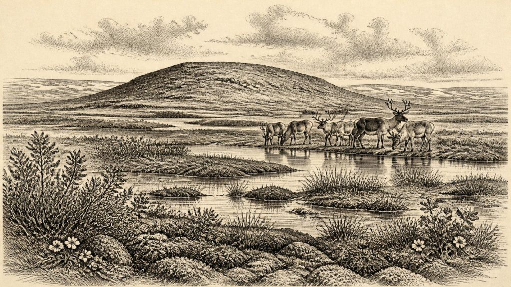
The fossils indicate an open, treeless and periglacial environment. Grasses, sedges, herbs and juniper occurred alongside a diverse moss flora. Finds associated with cold conditions include mountain-avens, dwarf willow, Arctic-alpine clubmoss and bogbean; water-milfoil points directly to freshwater. Insects, mosses and plant remains together suggest a muskeg-like mosaic: shallow pools and saturated margins, rich organic ground, exposed vegetation and seasonally frozen soil. It was not a forested Ireland, nor necessarily an island uniformly entombed beneath permanent ice.
That reconstruction must be kept local. Derryvree demonstrates an ice-free interval and freshwater habitat in this part of Fermanagh; it cannot prove that every district of Ireland was simultaneously open, habitable or alike in climate. Yet the sequence makes an important regional point. Glaciation was episodic and landscapes changed dramatically between ice advance, thaw, sediment accumulation and renewed ice cover.
Cold Country, Not Empty Country
The likely setting was harsh. Winters were long and cold, the growing season short, and vegetation low. A relatively productive wetland could nevertheless support insects, browsing mammals and predators, while dry ground may have carried sparse herb-rich tundra or steppe-tundra vegetation. The evidence does not justify a precise annual temperature, rainfall total or snow depth for Ireland in 30,825 BCE. It does support a landscape in which frost, waterlogging, wind exposure and changing drainage shaped everyday survival for plants and animals.
Crag Cave in County Kerry provides another kind of climate record. Stalagmites grow only when liquid water percolates through the cave, and uranium-thorium dating shows episodic growth during the last glacial period. In later MIS 3, their growth coincided with Greenland interstadials, while deposition ceased in cold stadials. This does not mean Derryvree and Crag Cave were identical environments, but it corroborates the wider interpretation that south-west Ireland experienced pronounced climatic swings rather than an unchanging Ice Age freeze.
Castlepook’s Animal World
Far to the south, Castlepook Cave preserves Ireland’s richest known pre-Last Glacial Maximum vertebrate assemblage. Early excavations recovered more than 2,000 bones from a complicated limestone cave system, and subsequent radiocarbon work showed that the collection spans a long interval, rather than one moment of deposition. Dates from individual remains range broadly from about 45,700 to 19,950 radiocarbon years BP. Castlepook must therefore not be treated as a campsite or a snapshot of one year.
Its fauna nonetheless establishes the wider biological possibilities of Late Pleistocene Ireland. Woolly mammoth, giant deer, reindeer, brown bear and spotted hyaena are among the animals represented, with wolf, Arctic fox, hare and lemmings also recorded in parts of the assemblage. Some remains were accumulated by carnivores and natural cave processes. They show that animals now absent from Ireland repeatedly reached, lived in, or at least passed through its changing landscapes. The island’s later Holocene fauna gives no adequate impression of this deeper, more varied world.
Large herbivores did not by themselves create a known human economy. But their presence indicates potential food webs across open country: grazing and browsing animals, scavengers and predators competing for carcasses, and mobile species responding to season, vegetation and ice margins. The cave record also warns against neat narratives of a single ‘mammoth-steppe’ population. The dated bones belong to different episodes, and animal distributions could have altered rapidly as climate, sea level, ice and vegetation changed.
The Human Question
Castlepook also contains the most provocative possible evidence for people in Ireland at this very early date: a reindeer femur bearing a deep mark interpreted by zooarchaeologist Ruth Carden as damage from a sharp stone implement during fresh-bone butchery. The bone has been publicly associated with an age around 33,000 radiocarbon years BP. If the modification is confirmed as a human-made cut contemporary with the animal’s death, it would point to Upper Palaeolithic people handling a reindeer in Ireland far earlier than the formerly accepted record.
The limits are as important as the possibility. The specimen derives from an old cave collection, not a newly excavated and sealed occupation surface. There is no securely associated hearth, stone-tool assemblage, dwelling, burial, human bone, repeated food-preparation area or other evidence of a resident community of comparable age. A radiocarbon date establishes the age of the animal bone, not automatically the moment or agent of the mark. Damage must be distinguished from breakage, trampling, carnivore action, sediment movement and excavation disturbance.
Consequently, Ireland around this point cannot responsibly be described as settled by a named people, culture or population. A brief visit by a very small party of mobile hunter-gatherers is a plausible interpretation if the cut-mark reading proves sound; permanent occupation, population size, language and ancestry remain unknown. The possible trace is important precisely because it is so slight. It encourages further investigation, not a fully peopled narrative.
No Politics, but Profound Change
There is no evidence for political institutions, rulers, diplomacy, warfare, trade routes, farming, livestock, cultivated crops, formal religious monuments or learned traditions in Ireland at 30,825 BCE. Their absence from the record does not mean that a hypothetical visiting group lacked social relationships, beliefs or knowledge. It means the surviving evidence cannot recover them. No Irish artefact demonstrates exchange with Britain or continental Europe at this date, and lower sea level does not itself demonstrate a permanent land bridge or an easy crossing route.
The major development was environmental. Ice-sheet growth after about 35,000–32,000 years ago eventually culminated in a much more extensive glacial maximum during MIS 2, broadly 27,000–21,000 years ago. Around the notional year considered here, the availability of wetland, pasture, caves and travel corridors was already contingent on fast-changing conditions. Later ice would scour terrain, remake drainage and conceal many of the older traces that archaeologists would most like to find.
For this reason, the story of Ireland at 30,825 BCE is not one of kings or settlements, but of evidence preserved against the odds: freshwater silt beneath a Fermanagh drumlin, intermittent calcite growth in a Kerry cave, and bones from a Cork cavern. These archives reveal a cold but living island, ecologically connected to wider north-western Europe and poised before another profound reorganisation of ice, coast and habitat.
Primary Sources
- A Middle Midlandian Freshwater Series at Derryvree, Maguiresbridge, County Fermanagh, Northern Ireland
- Palaeoecology
- Figure 6.— The Subdivision of the Quaternary Period in Ireland
- Castlepook Cave
- A Reconsideration of the Radiocarbon Dating of the Marine Isotope Stage 3 Fauna from Southern Ireland
- Episodic Speleothem Deposition Tracks the Terrestrial Impact of Millennial-Scale Last Glacial Climate Variability in SW Ireland
- New Insights on the Fauna of Ireland’s Younger Dryas
- Late Midlandian, Pleistocene, Northern Ireland
- Extent and Timing of the Last Glacial Maximum (LGM) in Britain and Ireland: A Review
- Maximum Extent and Dynamic Behaviour of the Last British–Irish Ice Sheet West of Ireland
- The Evolution of the Terrestrial-Terminating Irish Sea Glacier During the Last Glaciation
- Maximum Extent and Readvance Dynamics of the Irish Sea Ice Stream and Irish Sea Glacier Since the Last Glacial Maximum
- Sedimentary and Foraminiferal Records of Late Quaternary Environmental Change West of Ireland and Implications for the Last British–Irish Ice Sheet
- Pattern and Timing of Retreat of the Last British-Irish Ice Sheet
- Pattern, Style and Timing of British–Irish Ice Sheet Advance and Retreat Over the Last 45,000 Years
- The IntCal20 Northern Hemisphere Radiocarbon Age Calibration Curve (0–55 cal kBP)
- IntCal Publications
- Greenland Ice Core Chronology 2005 Data
- The Greenland Ice Core Chronology 2005, 15–42 ka
- Heritage Artefacts of County Cork
- The Mesolithic in Ireland: When Was It?
- Castlepook Caves