

Maguirebridge’s Windblown Pools31763 BCE
Around 31,763 BCE is a modern label, not a recoverable Irish historical date. During MIS 3, fluctuating ice margins intermittently left habitable open terrain. Derryvree, near Maguiresbridge, preserves freshwater sediments between tills, indicating cold, treeless wetlands with pools, mosses, sedges, grasses, insects and brief growing seasons, although its calibrated dates predate the specified year. Crag Cave speleothems record interstadials. Castlepook Cave’s mixed, disturbed bone assemblage demonstrates presence of mammoth, reindeer, giant deer, predators and cold-adapted fauna, but not their contemporaneity. A contested cut-marked reindeer bone suggests possible intermittent human visits, not settlement. Evidence reveals ecological conditions, not politics or society.
Dateline
“31,763 BCE” is a modern chronological label, not a year that can be recovered from an Irish record of events. Nobody in Late Pleistocene Ireland kept calendars, built dated monuments or left a continuous settlement sequence from which a particular year can be isolated. For this remote period, even the most useful scientific dates are ranges with stated uncertainties. The closest responsible setting is the later part of Marine Isotope Stage 3 (MIS 3), before the Last Glacial Maximum, when climate in north-west Europe fluctuated sharply and the Irish landscape was changing on scales of centuries and millennia rather than political years.
In calendar terms, 31,763 BCE is about 33,700 years before the radiocarbon convention’s “present” of 1950. That arithmetic must not be confused with a direct radiocarbon age. Radiocarbon years and calendar years differ because atmospheric carbon-14 has varied through time; calibrating an ancient measurement produces probability ranges rather than a single secure date. The evidence discussed here therefore illuminates a broad interval around the thirty-fourth millennium BCE, not one winter, migration or human generation.
A Landscape Between Ice Advances
Ireland lay in the long cold span generally called the Midlandian glaciation, the Irish expression of the last glacial cycle. Yet it was not simply a country locked permanently beneath an ice sheet. Ice expanded and contracted across different sectors at different times. The great British-Irish Ice Sheet would later grow into its local maximum extent, but the picture for the earlier interval is one of uneven, mobile ice margins and substantial areas capable, at times, of supporting tundra plants and grazing animals.
The clearest Irish archive relevant to this world came from Derryvree townland, near Maguiresbridge in County Fermanagh. Roadworks in 1969 cut through a drumlin and exposed freshwater silts and fine sands sealed between two distinct tills: deposits left by glaciers before and after the organic-bearing layer. This geological sandwich is unusually valuable. It demonstrates that a freshwater environment existed at Derryvree during an interval between major ice advances, before later ice reshaped the drumlin and buried its contents.
A conventional radiocarbon measurement on the Derryvree organic sediments was 30,500 +1,170/−1,030 radiocarbon years BP. Later work using modern calibration has expressed the result broadly at about 37,200–35,700 cal BP. That range is older than the numbered year considered here, and Derryvree cannot serve as a weather report for the whole island. It nevertheless remains the best excavated Irish environmental window onto the preceding and broadly comparable middle-to-late MIS 3 landscape. Its value is in showing what ice-free Irish ground could contain: wet hollows, open water, mosses, sedges and cold-adapted life.
Moss, Sedge and Open Ground
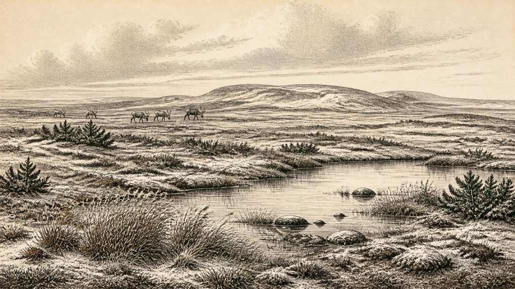
The Derryvree silts contained pollen, plant remains, mosses and insects. Together they point to an open, treeless environment rather than woodland. Grasses, sedges, herbs and juniper were important elements, while aquatic plants and mosses indicate marshy ground and pools rich in decaying plant matter. The insects supported this reading: they suggest wet muskeg-like terrain, with open water set among mossy vegetation. Such evidence is more secure than any attempt to paint a fully detailed panorama. It records plants and ecological conditions at a particular place, not a uniform island-wide biome.
The climate was severe. The original Derryvree study inferred bitter winters and cool summers, although exact temperature estimates should be treated cautiously because they depend on comparisons with modern species and habitats. Wind, frost action and seasonally frozen ground probably governed much of the surface. There may have been brief growing seasons in which grasses and herbs could flower, insects could reproduce and herbivores could graze. A low, patchy cover of shrubs and tundra plants would have offered far less shelter and far fewer reliable plant foods than the later forested Ireland familiar from the Holocene.
South-western Ireland adds a different kind of evidence. At Crag Cave in County Kerry, uranium-thorium dating of calcite speleothems shows repeated phases of cave-calcite growth during the last glacial period. Calcite deposition requires liquid water moving through the limestone, and the dated growth episodes broadly match warmer Greenland interstadials. This does not prove that every part of Ireland was mild, nor does it identify conditions in a particular calendar year. It does show that the last Ice Age contained abrupt environmental oscillations: intervals when water could circulate underground and others when cold conditions inhibited that process.
Animals at Castlepook
In north County Cork, Castlepook Cave near Doneraile preserves Ireland’s richest known collection of pre-Last Glacial Maximum vertebrate remains. More than 2,000 bones have been recovered from its galleries and chambers, whose antiquarian names include Elephant Hall and Hyena Hall. The assemblage includes woolly mammoth, giant deer, reindeer, brown bear, wolf, foxes, Arctic fox, spotted hyaena and lemmings. It establishes beyond doubt that, during portions of the Late Pleistocene, Ireland was not biologically isolated from the wider north-west European world.
That conclusion needs careful wording. The cave was a trap, den and sedimentary repository over a long period, not a neatly layered campsite. Water movement, animal activity and early twentieth-century excavation disturbed deposits. Bones of different ages entered the system, and later material could intrude. Recent redating has also shown that several earlier radiocarbon results from Irish cave collections were too young, in some cases by thousands of years, because improved pretreatment extracts more reliable collagen from ancient bone. A list of animals from Castlepook is therefore evidence for regional presence over a long interval, not proof that mammoths, hyaenas, bears and every recorded species stood together outside the cave in 31,763 BCE.
Even so, the fauna makes ecological sense for cold open country. Reindeer could exploit tundra vegetation; lemmings and Arctic foxes indicate harsh conditions; wolves and spotted hyaenas were predators and scavengers within a food web that also included large herbivores. Hyaenas may have carried some bones into the cave, affecting both what survived and what archaeologists can infer from it. The absence of some familiar mainland Ice-Age animals, such as woolly rhinoceros and bison, is also notable, but absence in Ireland’s sparse fossil record is not automatically proof that a species never reached the island.
People: A Possibility, Not a Population
The human story at this date is especially uncertain. Ireland has no securely excavated dwelling, hearth, stone-tool assemblage, burial or occupation surface dated to the thirty-fourth millennium BCE. There is consequently no responsible basis for describing clans, chiefs, territorial boundaries, diplomatic relations, warfare, ritual institutions or a settled Irish society. Nor can later Gaelic, Celtic or medieval identities be projected backwards into this far older and discontinuous past.
A reindeer femur from Castlepook has, however, drawn justified attention. An incision on the bone has been interpreted as a mark made while fresh by a sharp stone tool, potentially indicating the butchery of a reindeer by people during the Late Pleistocene. If that interpretation and its association with the bone’s age are sustained, it would push possible human activity in Ireland far earlier than the better-known terminal Palaeolithic evidence. But it is one contested and isolated trace from a disturbed cave context. The cut itself cannot independently supply an exact date, and a single modified bone cannot demonstrate a resident population.
The most cautious interpretation is that the island may have been visited intermittently by highly mobile hunter-gatherers when geography and climate permitted, perhaps following animal movements or exploiting a short-lived opportunity. That is an inference, not an established fact for this year. If people were present, they would have possessed knowledge, social bonds, language and cultural practices; archaeology’s silence does not mean they lacked them. It means Ireland has not yet yielded sufficient securely dated material to describe those practices here.
No Politics, No Trade Network
For the same reason, there is no evidence for political affairs, diplomacy or organised conflict in Ireland around this point. No farms, crops, livestock, pottery, metalwork, settlements or trade goods are known. The economy that can be discussed is ecological rather than institutional: plants converting a brief summer into grazing, herbivores moving through open country, predators and scavengers competing for carcasses, and water and ice repeatedly altering routes across the landscape.
Lower global sea levels changed the setting of Ireland, exposing wider continental shelves around Britain and Ireland than exist today. These shelves may have reduced marine barriers at some times, but the exact configuration, sea crossings, coastlines and land connections relevant to particular animal movements remain matters for reconstruction. Faunal arrivals show connectivity was possible; they do not prove a permanent dry-land bridge, a regular trading route or a settled migration corridor at this specific date.
A Record of Conditions
The Ireland of around 31,763 BCE is therefore best understood through conditions, not events. Derryvree’s buried freshwater sediments preserve a cold, open wetland landscape from an earlier part of the same glacial world. Castlepook’s difficult cave bones reveal that large mammals repeatedly reached Ireland before the Last Glacial Maximum. Crag Cave records climatic pulses in underground calcite. Together they show an island of ecological opportunity and rapid constraint, where ice, water, wind and animal movement mattered more than the historical categories of kingdom, church, market or state. The evidence is fragmentary, but its restraint is its strength: it allows a real, if incomplete, Irish prehistory to emerge without pretending that a modern calendar label was ever a date in Ice-Age life.
Primary Sources
- A Middle Midlandian Freshwater Series at Derryvree, Maguiresbridge, County Fermanagh, Northern Ireland
- Irish Pleistocene Biostratigraphy
- The Irish Quaternary Fauna Project
- A Reconsideration of the Radiocarbon Dating of the Marine Isotope Stage 3 Fauna from Southern Ireland
- Episodic Speleothem Deposition Tracks the Terrestrial Impact of Millennial-Scale Last Glacial Climate Variability in SW Ireland
- Growth and Retreat of the Last British–Irish Ice Sheet, 31,000 to 15,000 Years Ago: the BRITICE-CHRONO Reconstruction
- Trimlines, Blockfields and the Vertical Extent of the Last Ice Sheet in Southern Ireland
- The Timing and Magnitude of the British–Irish Ice Sheet Between Marine Isotope Stages 5d and 2
- Character of Advance and Retreat of the Southwest Sector of the British-Irish Ice Sheet During the Last Glaciation
- Exploring Controls of the Early and Stepped Deglaciation on the Western Margin of the British Irish Ice Sheet
- Castlepook Cave, County Geological Site Report
- Archaeological Heritage of County Cork
- Archaeology Research Excavation Grant 2022: Final Report
- New Insights on the Fauna of Ireland’s Younger Dryas and Early Holocene from Alice & Gwendoline Cave
- The IntCal20 Northern Hemisphere Radiocarbon Age Calibration Curve (0–55 cal kBP)
- Radiocarbon Calibration
- OxCal
- Occurrence of Mammalia Relicts at Site Castlepook Cave
- Pleistocene Vertebrates in the British Isles
- The Geological Heritage of County Leitrim