
Derryvree’s Inter-Till Fen31612 BCE
Labelled 31,612 BCE, this period cannot be dated to a single Irish year and is understood through environmental evidence. At Derryvree, County Fermanagh, freshwater sediments between glacial tills record an ice-free interval within MIS 3, broadly dated to 36,900–31,700 calibrated BP. Pollen, plants and insects indicate treeless, wet tundra or muskeg under periglacial conditions. Ireland experienced asynchronous ice advances before the glacial maximum. Cave faunas demonstrate that mammoths, reindeer, giant deer, bears and hyaenas reached Ireland during MIS 3, probably via intermittent land connections. No securely evidenced human occupation or society is known; the record documents landscape, fauna and ice.
Dateline
“31,612 BCE” is a modern filing label, not a date that can be recovered from the Irish archaeological record. Nobody in Ireland counted years in this manner, no written testimony exists, and neither radiocarbon dating nor glacial deposits can distinguish one calendar year from the next at such depth in time. The label corresponds roughly to 33,561 years before AD 1950, the conventional radiocarbon ‘present’. It belongs to the later part of Marine Isotope Stage 3 (MIS 3), a fluctuating cold phase of the Late Pleistocene. The most responsible account of Ireland at this point is therefore not an annal of events, rulers or settlements, but a reconstruction based on sediments, fossils, landforms and carefully qualified dates.
A Broad Chronological Window
The best Irish evidence close to this nominal year comes from Derryvree, near Maguiresbridge in County Fermanagh. Road excavations in 1969 cut through a drumlin and exposed a striking sequence: freshwater silts and fine sands containing organic material lay between two separate thick layers of till, the unsorted debris deposited by glacier ice. The order of the layers provides the central fact. An earlier ice advance laid down the lower till; a period without local ice permitted water, sediment, plants and small animals to accumulate; a later advance buried the deposit beneath the upper till. The Derryvree evidence does not tell us what happened in 31,612 BCE itself. It does demonstrate that north-central Ireland had an ice-free interval during this wider cold-stage sequence.
Organic material from the freshwater beds produced a conventional radiocarbon age of 30,500 years BP, with a substantial uncertainty of +1,170 and −1,030 years. Published calibrations place the deposit broadly at about 36,900–31,700 calibrated years BP, approximately 34,950–29,750 BCE when expressed in BCE terms. The nominal year falls within that wide span, but cannot be located more precisely inside it. Calibration is essential because radiocarbon years are not direct calendar years: atmospheric carbon-14 concentrations have altered through time. At around 34,000 calendar years ago, even the most sophisticated calibration curves provide ranges rather than a historical stopwatch. Derryvree should thus be read as evidence for an environmental interval, not for a dated episode.
Wet Ground Beneath the Drumlin
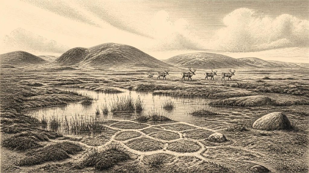
The plants, insects and sediments at Derryvree describe a cold, open landscape rather than the wooded Ireland familiar today. The original investigators identified a flora and fauna of full-glacial character and interpreted the setting as treeless tundra under a periglacial climate: ground shaped by repeated freezing and thawing at the margins of ice. Later syntheses have likened the local habitat to muskeg, a waterlogged mosaic of mossy ground, sedges, shallow pools and plant-rich margins. Such a landscape was neither a uniform frozen desert nor a modern bog transplanted into the past. It was a wet, exposed environment in which water could persist seasonally or locally even while winters were severe and frost was a powerful agent of change.
This modest Fermanagh deposit matters because it preserves a living surface later concealed by ice. Fine sediments retained pollen, plant macrofossils and insect remains that are normally lost when glaciers erode and redeposit older ground. The evidence supports the presence of open vegetation and freshwater habitats around Derryvree; it does not licence a map showing all of Ireland as the same kind of tundra at one moment. Conditions varied with altitude, drainage, latitude, proximity to ice and the changing North Atlantic climate. The record at nearby Greenagho, also beneath till in Fermanagh, is older, while cave deposits in the south have their own complex histories. Ireland was a changing patchwork, not a single climatic zone.
Ice Was Building, Not Yet at Its Greatest Extent
This was an age of instability rather than the final peak of the last glaciation. The great British–Irish Ice Sheet had not yet reached its maximum volume, which current large-scale reconstructions place much later, around 23,000 years BP, with different sectors advancing and retreating at different times. Ice expansion around Ireland was asynchronous. Some areas could retain or receive ice while others remained exposed; a local ice-free deposit does not prove that the whole island was ice-free. Nevertheless, Derryvree and other pre-Last Glacial Maximum records are important checks against an older, over-simple image of Ireland as continuously buried beneath one unchanging ice cap.
Climate shifts across MIS 3 could be abrupt on geological timescales. Greenland ice cores reveal repeated interstadials and stadials, episodes of relative warming and cooling whose North Atlantic effects reached the western edge of Europe. In south-west Ireland, the interrupted growth of calcite deposits in Crag Cave offers an independent indication that conditions alternated between periods when liquid water could circulate through shallow cave systems and periods too cold for such growth. Correlating a particular Irish sediment directly with a named Greenland event remains cautious work, especially where dates are broad. The important conclusion is not a precise weather report, but the sensitivity of Irish land, ice and drainage to repeated climatic shifts.
Animals and a Connected Landmass
Southern cave collections show that Ireland was inhabited at various times during MIS 3 by a far richer mammal community than survives today. Castlepook Cave, or Mammoth Cave, near Doneraile in north County Cork is the island’s most important repository of fauna from the period leading towards the Last Glacial Maximum. Its assemblage includes woolly mammoth, reindeer, giant deer, brown bear and spotted hyaena, with later cold-stage records also including Arctic fox, wolf and lemmings. These animals should not all be placed together at Derryvree in the nominal year. Cave deposits can combine material accumulated over long periods, and renewed dating has shown that several older determinations from Castlepook require reassessment. Fossils establish presence somewhere in Ireland within dated intervals, not a single contemporary herd or hunting scene.
Even so, the animals reveal important ecological connections. Lower sea levels and changing ice configurations sometimes made movement between Ireland, Britain and continental Europe possible, whether across exposed terrain, coastal corridors or short-lived land connections. The exact geography and duration of such connections remain debated because relative sea level, isostatic crustal movement and ice margins all changed. It is safer to say that Ireland was not inevitably isolated throughout MIS 3. Mammoth, hyaena and reindeer remains show that terrestrial mammals did reach the island during the wider period. Their arrival required accessible routes and suitable habitat, while their later disappearance reflects both environmental change and the severe disruptions associated with advancing ice.
No Demonstrable Community
There is no securely published settlement, hearth, stone-tool assemblage, grave, house or worked object that permits a description of Irish human society in or specifically near 31,612 BCE. Nor is there evidence for political authority, diplomacy, warfare, trade networks, ritual practice, language, art or formal learning on the island at this date. It would be misleading to populate the Derryvree wetland with a named hunter-gatherer band merely because humans were present elsewhere in Upper Palaeolithic Europe. Human dispersal on neighbouring landmasses makes occasional visits to Ireland conceivable, particularly during phases of low sea level and faunal movement; it does not turn possibility into evidence.
A reported reindeer femur from Castlepook has attracted attention because surface marks have been interpreted as possible traces of stone-tool butchery and the bone has been associated in public discussion with an age of about 33,000 years. That claim has not supplied a published, securely contextualised archaeological occupation comparable to recognised Palaeolithic sites elsewhere in Europe. It should therefore remain separate from the environmental evidence. The appropriate conclusion for this date is that Ireland contained habitable, though demanding, landscapes for cold-adapted animals and perhaps transient human movement, but no known resident population. The earliest firmly documented human activity in Ireland belongs much later, after the main ice-sheet phase.
The History Is Environmental
For this remote point in Irish history, the great development was environmental change. Water gathered in a hollow near present-day Maguiresbridge; sedges, mosses and other tundra plants occupied its margins; insects lived in and around the wet ground; later glacier ice sealed the evidence beneath a drumlin. Far to the south, cave chambers accumulated bones whose study continues to revise the chronology of Ireland’s Ice Age fauna. These are not minor substitutes for lost chronicles. They are the primary record. Derryvree gives Ireland at 31,612 BCE a discernible setting: open, cold, wet, locally ice-free terrain within a wider world of shifting climate, mobile animals and approaching ice. What it cannot give is a year-by-year narrative, and recognising that limit is part of telling the period faithfully.
Primary Sources
- A Middle Midlandian Freshwater Series at Derryvree, Maguiresbridge, County Fermanagh, Northern Ireland
- The IntCal20 Northern Hemisphere Radiocarbon Age Calibration Curve (0–55 cal kBP)
- Irish Pleistocene Biostratigraphy
- Figure 6—The Subdivision of the Quaternary Period in Ireland
- Trimlines, Blockfields and the Vertical Extent of the Last Ice Sheet in Southern Ireland
- A Reconsideration of the Radiocarbon Dating of the Marine Isotope Stage 3 Fauna from Southern Ireland
- The Irish Quaternary Fauna Project
- Castlepook Cave
- Spotted Hyena Skull
- Ice Age Ireland: Cool Fossils!
- Episodic Speleothem Deposition Tracks the Terrestrial Impact of Millennial-Scale Last Glacial Climate Variability in SW Ireland
- Growth and Retreat of the Last British–Irish Ice Sheet, 31,000 to 15,000 Years Ago: the BRITICE-CHRONO Reconstruction
- Exploring Controls of the Early and Stepped Deglaciation on the Western Margin of the British Irish Ice Sheet
- Deglaciation, Earth Crustal Behaviour and Sea-Level Changes in the Determination of Insularity: A Perspective from Ireland
- A Stratigraphic Framework for Abrupt Climatic Changes During the Last Glacial Period Based on Three Synchronized Greenland Ice-Core Records
- New Insights on the Fauna of Ireland's Younger Dryas and Early Holocene from Alice & Gwendoline Cave
- First Evidence of a Late Upper Palaeolithic Human Presence in Ireland
- The Mesolithic in Ireland: When Was It?
- Pleistocene Vertebrates in the British Isles
- Field Guides
