
The Derryvree Freshwater Series31611 BCE
31,611 BCE is a modern approximate label for Ireland during Marine Isotope Stage 3, rather than a recoverable historical year. At Derryvree, County Fermanagh, freshwater silts between glacial tills record an interval of cold, non-glacial conditions before later ice expansion. Mosses, sedges, herbs, insects and aquatic plants indicate open, wet tundra with severe winters, not forest or permanent ice. Faunal remains, including reindeer and mammoth, demonstrate intermittent links with wider European ecosystems. Castlepook Cave preserves contested possible cut marks suggesting human activity, but not settlement. Subsequent Last Glacial Maximum ice reshaped Ireland, preserving evidence of a severe, intermittently habitable landscape.
Dateline
“31,611 BCE” is a modern chronological label, not a year that can be recovered from Irish evidence. No calendar, written record, named leader or dated event existed in Ireland at this depth of time. In archaeological terms, the label falls roughly 33,560 calendar years before present, with “present” conventionally fixed at AD 1950. Such conversions are necessarily approximate. Radiocarbon results must be calibrated, their uncertainties can extend across centuries or millennia, and an age for bone or sediment does not identify a particular season, community or historical incident.
The responsible subject is therefore Ireland around this point: a Late Pleistocene landscape within Marine Isotope Stage 3, long before the Last Glacial Maximum. The best evidence is environmental rather than political. Freshwater silts, pollen, plant macrofossils, insect remains, cave bones and the arrangement of glacial deposits offer fragments of a changing country. They illuminate ice-free ground in some areas, cold-adapted life and the possibility of fleeting human activity, but they do not support a narrative of settlements, tribes or rulers.
A Date Within a Range
The closest well-studied Irish archive is at Derryvree, near Maguiresbridge in County Fermanagh. Road excavations in 1969 cut through a drumlin and exposed fine sands and organic freshwater silts trapped between two separate sheets of till, the unsorted sediment left by glacier ice. This sequence matters more than any single numerical date. Ice had affected the locality before the freshwater deposit accumulated; later ice covered and preserved it. Derryvree consequently demonstrates a substantial interruption in glacial conditions, not an unbroken frozen landscape across all Ireland.
Organic material from the deposit returned a conventional radiocarbon age of 30,500 +1,170/−1,030 radiocarbon years BP. In calibrated form, scholarship has placed its probable age broadly within the later part of MIS 3; one commonly used calibrated range is about 36,900–31,700 calendar years BP. The modern year-label 31,611 BCE lies broadly within that kind of chronological horizon, but it cannot be assigned to a layer within the deposit. Derryvree is an archive of an interval, not a diary for a single year.
Comparable deposits elsewhere in Fermanagh reinforce the larger conclusion while showing why precision is difficult. Freshwater organic sediments at Hollymount and Greenagho were also preserved beneath later till. Their dates and stratigraphic histories are not equally secure, and some legacy determinations are treated cautiously, yet together they show that parts of northern Ireland experienced cold, non-glacial episodes before the later expansion of the British–Irish Ice Sheet. They do not prove that every Irish valley, coast or upland had the same conditions at the same time.
Wet Tundra, Not Empty Ice
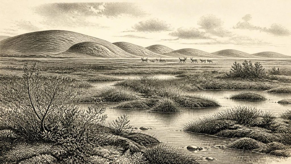
Derryvree’s biological remains give the clearest picture of everyday surroundings. The deposit contained freshwater mosses and sedges, herb pollen, insect remains and macrofossils associated with open tundra vegetation. Bogbean, dwarf willow, mountain avens, lesser clubmoss and water-milfoil are among the recorded indicators. Their presence does not mean that a neat modern plant community stood unchanged at the site. Rather, each is evidence that particular wet, exposed or shallow-water habitats could exist within a harsh periglacial environment.
The resulting landscape was probably a mosaic. Low ground could hold mossy, sedge-rich marsh, pools and slow water; better-drained patches supported herbs and sparse low shrubs; frost action repeatedly disturbed soils. Trees were absent locally or extremely scarce. Poorly preserved grains of pine and hazel pollen are not good evidence for a forest: they may have travelled far or entered sediments secondarily. The stronger signal is of open country, with a short growing season and severe winters.
“Periglacial” is important here. It describes ground shaped by intense freezing and thawing near ice, not necessarily ground permanently buried beneath a glacier. Water could flow and freshwater vegetation could grow during favourable seasons, while winter frost and low temperatures placed firm limits on soils and plant cover. This was not modern Fermanagh with its fields, woods and lough margins, though it was not a featureless polar desert either. Derryvree preserves a cold wetland in a landscape capable of supporting specialised plants, insects and, where routes and forage allowed, grazing animals.
Animals in a Mobile Landscape
Cave deposits in southern Ireland show that a varied cold-stage fauna reached the island during MIS 3. Castlepook Cave near Doneraile, County Cork, has produced remains attributed to reindeer, brown bear, Arctic hare, fox, spotted hyaena, mammoth and other animals. Dates have been repeatedly reassessed as radiocarbon methods and chemical pretreatment improved. The central conclusion is not that every species occupied every district simultaneously, but that Ireland was connected to wider north-west European ecological networks during portions of the Late Pleistocene. Sea levels were far lower than today, coastlines lay far beyond their present positions, and the Irish Sea region presented a very different geographical threshold.
Reindeer are especially useful for imagining the practical ecology of open ground. Herds could exploit tundra and steppe-like vegetation, moving seasonally through landscapes that also attracted predators and scavengers. Spotted hyaena bones and cave accumulations warn against assigning every animal remain to people: caves were used or entered by carnivores, and bones may have been moved, gnawed, redeposited or exposed long after death. A mammoth or reindeer bone tells us that an animal reached Ireland; it does not by itself prove a hunting ground, a human camp or a permanent population.
At 31,611 BCE, then, the most defensible account of economy is an ecological one. There is no evidence for farming, domesticated animals, fields, stores, houses, craft production or organised trade in Ireland. Wild animals and plant resources formed the available subsistence base. If people were present, they would have depended on portable technologies, intimate environmental knowledge and short-term access to game, fuel, water and shelter. These are reasonable inferences from Upper Palaeolithic lifeways elsewhere in north-west Europe, not demonstrated facts about a documented Irish community.
The Human Question at Castlepook
The possibility of people in Ireland during this broad period has made Castlepook exceptionally important. A reindeer femur from the cave, held in the National Museum of Ireland collections, has been described as bearing a mark made by a sharp stone edge on fresh bone. Public interpretation of the specimen has associated it with a date of about 33,000 years ago. If microscopic and taphonomic study ultimately confirms that the mark is an anthropogenic cut, it would indicate that a person or small group processed animal tissue in Ireland far earlier than the island’s formerly accepted archaeological record.
That proposition must remain carefully bounded. The object came from older cave investigations, not from a newly excavated occupation surface containing a secure tool assemblage, hearth, shelter floor and repeated butchery debris. A cut mark, however suggestive, cannot establish whether people hunted the animal, scavenged it, stayed overnight or returned repeatedly. Nor can it identify language, ancestry, social organisation, ritual or a named Upper Palaeolithic culture. The proper description is possible human activity, not established settlement.
There is no responsible evidence for political affairs, diplomacy or warfare in Ireland at this date. Equally, there is no evidence for formal religion, monuments, burials, visual art or institutions of learning. People, if present, certainly possessed knowledge and social practices, but archaeology has not recovered Irish material that permits their content to be described. Silence in the record is not proof of cultural absence; it is a limit imposed by preservation, later glacial erosion and the very small number of securely investigated deposits.
Ice Yet to Come
The wider climatic setting was unstable. Ireland lay on the Atlantic fringe, where shifts in sea ice, ocean circulation and atmospheric circulation could alter temperature and moisture rapidly on geological timescales. U-series dates from Crag Cave in County Kerry show that speleothem growth during the last glacial occurred episodically during milder Greenland Interstadials. Because cave calcite requires liquid water moving through the ground, those growth episodes independently show that south-west Ireland periodically crossed the freezing threshold. They should not, however, be used to reconstruct a specific Fermanagh weather pattern for 31,611 BCE.
Later, during the Last Glacial Maximum, the British–Irish Ice Sheet expanded much more extensively, covering Ireland and reshaping or removing many earlier landscapes. Modern reconstructions place the global maximum broadly between 26,500 and 19,000 years ago, while the timing, thickness and movement of ice around Ireland varied regionally. The till above Derryvree’s freshwater sediments is physical testimony to that later transformation. What survived beneath it is precious precisely because most comparable evidence did not.
For Ireland around 31,611 BCE, the principal development was therefore neither a battle nor a dynasty but an environmental opening between glacial advances. In Fermanagh, cold freshwater pools and tundra plants occupied ground later sealed beneath ice. Across the island’s changing lowland corridors, large mammals could enter and depart. In Cork, cave deposits retain an intriguing, still contested hint that people may have touched this world. The evidence is slight, local and often difficult to date, but it is enough to replace the old image of an utterly blank Ireland with a more compelling one: a severe, dynamic and intermittently habitable Ice-Age landscape.
Primary Sources
- A Middle Midlandian Freshwater Series at Derryvree, Maguiresbridge, County Fermanagh, Northern Ireland
- The Irish Quaternary Fauna Project
- A Reconsideration of the Radiocarbon Dating of the Marine Isotope Stage 3 Fauna from Southern Ireland
- Late Pleistocene Chronostratigraphy and Ice Sheet Limits, Southern Ireland
- Episodic Speleothem Deposition Tracks the Terrestrial Impact of Millennial-Scale Last Glacial Climate Variability in SW Ireland
- Timing and Pace of Ice-Sheet Withdrawal Across the Marine–Terrestrial Transition West of Ireland During the Last Glaciation
- BRITICE Glacial Map, Version 2: A Map and GIS Database of Glacial Landforms of the Last British–Irish Ice Sheet
- Extent and Timing of the Last Glacial Maximum (LGM) in Britain and Ireland: A Review
- Dimensions and Chronology of the Last Ice Sheet in Western Ireland
- Last Glacial Maximum Cirque Glaciation in Ireland and Implications for Reconstructions of the Irish Ice Sheet
- Early Midlandian–Middle Midlandian, Pleistocene, Northern Ireland
- Palaeoecology: Irish Association for Quaternary Studies Field Guide
- The Subdivision of the Quaternary Period in Ireland
- Middle Midlandian Interstadial Deposits at Greenagho, Near Belcoo, County Fermanagh, Northern Ireland
- Menyanthes trifoliata
- Salix herbacea
- Dryas octopetala
- Selaginella selaginoides
- Myriophyllum alterniflorum
- IntCal20 Northern Hemisphere Radiocarbon Age Calibration Curve (0–55 cal kBP)
- Heritage Artefacts of County Cork
