
Maguirebridge’s Freshwater Series30840 BCE
30,840 BCE is a modern chronological label within a broad calibrated range, not a recorded Irish year. Derryvree, near Maguiresbridge, preserves freshwater sediments between glacial tills, indicating a cold, largely treeless wetland of sedges, mosses and Arctic-alpine plants during Marine Isotope Stage 3. Crag Cave shows intermittent milder conditions, while Castlepook Cave documents cold-stage fauna including mammoth, reindeer, giant deer and predators. A possibly cut-marked reindeer bone suggests, but does not prove, brief human activity. No settlement or society is evidenced. Environmental instability preceded expanding British-Irish ice, which eventually buried Derryvree’s freshwater landscape as glaciation progressively intensified across the region.
Dateline
A Calendar Label, Not an Anniversary
“30,840 BCE” is a modern way of placing a point in very deep time, not a year that anyone then living in Ireland could have named or recorded. No written evidence, dated settlement layer or historical event permits calendar-year precision. In radiocarbon terms the label lies roughly 32,790 years before AD 1950, but a radiocarbon measurement is not itself a calendar age: it must be calibrated, and at this depth in time the resulting ranges are broad. The responsible picture is therefore of Ireland during the Late Pleistocene, in Marine Isotope Stage 3, rather than of a particular day, season or generation.
The closest important Irish archive is the Middle Midlandian freshwater deposit at Derryvree, near Maguiresbridge in County Fermanagh. Organic-rich silts and sands found there between two layers of glacial till produced a conventional radiocarbon age of about 30,500 ± 1,170 radiocarbon years BP. Modern calibration places the deposit broadly around 36,900–31,700 calibrated years BP, approximately 34,950–29,750 BCE. The nominal year 30,840 BCE falls inside that wide interval. It cannot, however, be assigned to one individual bed, one pool or one moment within the sequence.
That distinction matters. Derryvree offers a securely ordered story of environmental change: glacier ice had deposited the lower till; an interval then allowed freshwater sediment, plants and insects to accumulate; later ice overran or approached the locality and sealed the deposit beneath another till. It is not a photograph of all Ireland. Yet, because later glaciation removed or buried so much older landscape, this small Fermanagh exposure is among the best windows onto the island’s changing conditions before the Last Glacial Maximum.
A Wetland Between Ice Advances
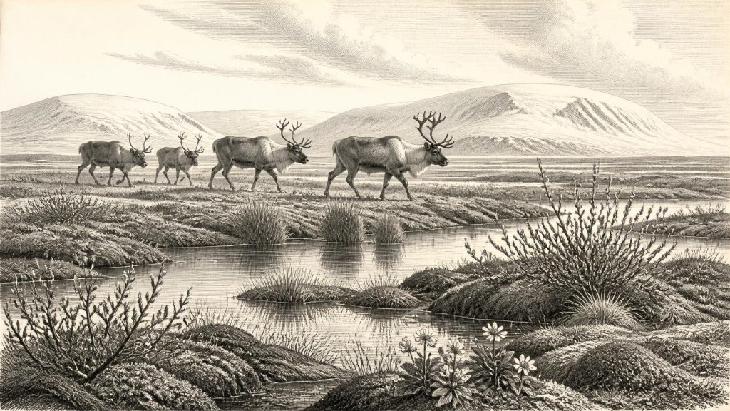
The Derryvree evidence indicates cold, open and wet ground rather than forest. Plant remains, pollen, mosses and insect evidence have been interpreted as a tundra or muskeg environment: waterlogged terrain with shallow pools, sedges, grasses, mossy margins and hardy Arctic-alpine plants. Records include dwarf willow, mountain-avens, bogbean, water-milfoil, clubmosses and a variety of mosses. Such plants do not mean that every square mile of Ireland looked alike. They demonstrate what could grow in and around this particular freshwater basin under severe cold-stage conditions.
Some pollen grains from trees occur in comparable deposits, but pollen can travel far on the wind or be reworked from older sediment. The local plant macrofossils and mosses are therefore more persuasive evidence for the immediate setting. The balanced conclusion is a largely treeless Fermanagh wetland, not a wooded countryside and not proof that the whole island was either ice-free or uniformly frozen. In an unstable North Atlantic climate, local topography, exposure, elevation and the shifting position of ice all mattered.
The wider climate was neither a simple descent into permanent cold nor a comfortable interlude. Greenland ice-core sequences and Irish cave records show that the last glacial period contained abrupt millennial-scale oscillations. At Crag Cave in County Kerry, episodes of stalagmite growth during Marine Isotope Stage 3 indicate times when liquid water could move through the shallow cave system and ground conditions were sufficiently mild for calcite to form. Growth ceases under sustained frozen or glaciated conditions. This does not provide a thermometer for Derryvree, but it supports the interpretation of a climatically restless island, in which short-lived ameliorations could interrupt a generally harsh trajectory towards more extensive ice.
Animals in a Fragmented Landscape
County Cork provides the principal Irish record of large Late Pleistocene mammals. Castlepook Cave, near Doneraile, was excavated principally in the early twentieth century and yielded remains attributed to mammoth, reindeer, giant deer, red deer, wolf, fox, Arctic fox, brown bear, spotted hyaena, mountain hare and lemmings. A conventional radiocarbon determination of 33,400 ± 1,200 BP on a mammoth bone has long supported a Middle Devensian, or Midlandian, age for at least part of the assemblage.
But Castlepook must be read carefully. Cave deposits accumulated through many processes: carnivores dragged in prey, animals died or sheltered underground, water moved sediments, and early excavation disturbed and mixed material. Not every bone need be contemporary, and the cave fauna should not be imagined as a single herd gathering beneath one cliff. What it reliably conveys is that Ireland could support, or be reached by, a striking cold-stage fauna before the fullest expansion of the last ice sheet. Reindeer and lemmings point towards cold open environments; mammoth and giant deer evoke extensive grazing country; hyaenas, wolves and foxes indicate predators and scavengers within the food web.
The landscape was consequently more dynamic than the modern island suggests. Large herbivores would have moved through open habitats in search of forage, while predators and scavengers followed opportunities created by herds, carcasses and sheltering places. Their presence is evidence for ecological connections across the wider north-west European region, but it does not establish one route, one migration season or a permanent animal population in every Irish region. Sea level, ice margins and exposed shelves changed repeatedly, while the details of local access remain difficult to reconstruct.
The Human Question
There is no excavated dwelling, hearth, tool assemblage, grave, artwork or securely dated human bone from Ireland that can be assigned to 30,840 BCE. Accordingly, there is no basis for describing an Irish community, a language, a leader, a territory or a political system at this date. There were no states, diplomacy or wars identifiable in the evidence. Nor can religion, ritual practice, teaching, kinship rules, trade networks or artistic traditions be responsibly supplied from analogy with better-documented Upper Palaeolithic societies elsewhere in Europe.
One object has made the question more complicated. A reindeer femur from Castlepook has been described as bearing a deep mark consistent with cutting or chopping by a sharp stone tool, and County Cork heritage material has presented it as possible evidence of human carcass processing about 33,000 years ago. If that interpretation is confirmed through further microscopic, taphonomic and chronological work, it would point to a brief Upper Palaeolithic human presence far earlier than Ireland’s formerly accepted evidence.
Even then, the inference must remain modest. One marked bone would show an action upon a carcass, not a settlement, a seasonally occupied camp or a resident population. It would not identify the people involved, their cultural affiliation, whether they arrived by water or across a temporarily accessible wider landscape, or how long they stayed. In the absence of associated stone tools, hearths and an undisturbed excavated context, Castlepook is best treated as a significant research question rather than a foundation for a populated prehistoric narrative.
No Economy, No Polity, but a Living Environment
It is tempting to make every annual entry resemble later history, with rulers, alliances, commerce and belief. Here the evidence requires a different emphasis. There is no demonstrable economy in the human sense: no farming, herding, quarrying, exchange, buildings or managed settlement can be dated to this point. There is likewise no evidence for a religious institution, formal learning or cultural transmission within Ireland. The only securely observable “society” is ecological: plants, insects and animals responding to water, temperature, vegetation and ice.
That is not an empty history. Derryvree records sedges and aquatic plants taking hold where ice had retreated or failed to occupy ground. Castlepook preserves the bones of animals using a landscape sufficiently productive to sustain both grazers and carnivores. Crag Cave records intervals in which groundwater again deposited calcite. Together, these archives show regional change rather than a static Ice Age wilderness. Ireland at this point was a mosaic of ice-influenced land, periglacial open ground, wetlands, caves and routes whose availability altered with climate.
Approaching the Great Glaciation
The most important development around this date was environmental instability on the approach to the Last Glacial Maximum. Recent British–Irish Ice Sheet reconstructions begin at about 31,000 years ago because evidence for earlier margins is sparse and uncertain; they indicate growing ice centres and a subsequent major expansion, with maximum extent broadly around 26,000–20,000 years ago. The two tills at Derryvree make the local consequence vivid: a freshwater landscape existed between glacial episodes, but it was ultimately buried within a changing ice-sheet history.
For 30,840 BCE, then, the proper subject is not an invented human event but a vulnerable landscape. Fermanagh’s buried freshwater sediments offer the clearest nearby chronological anchor. Cork’s cave bones reveal a cold-stage animal world, while one disputedly modified reindeer bone keeps open the possibility of a very brief human encounter. The surviving evidence is sparse, discontinuous and often difficult to date. Its value lies precisely in what it can establish: not a named year in Irish history, but an island-region of wetlands, open cold-country fauna and advancing climatic uncertainty.
Primary Sources
- A Middle Midlandian Freshwater Series at Derryvree, Maguiresbridge, County Fermanagh, Northern Ireland
- Figure 6.— The Subdivision of the Quaternary Period in Ireland
- Growth and Retreat of the Last British–Irish Ice Sheet, 31,000 to 15,000 Years Ago: the BRITICE-CHRONO Reconstruction
- Episodic Speleothem Deposition Tracks the Terrestrial Impact of Millennial-Scale Last Glacial Climate Variability in SW Ireland
- Spatio-Temporal Dynamics of Speleothem Growth and Glaciation in the British Isles
- The Colonization of Ireland: A Human Ecology Perspective
- First Evidence of a Late Upper Palaeolithic Human Presence in Ireland
- New Insights on the Fauna of Ireland's Younger Dryas and Early Holocene from Alice & Gwendoline Cave
- Heritage Artefacts of County Cork
- On the Cave of Castlepook, Near Doneraile, Co. Cork
- Pleistocene Vertebrates in the British Isles
- The Irish Quaternary Fauna Project
- Castlepook Cave, Castlepook South, County Cork: Excavation Report 2022
- IntCal Publications
- The IntCal20 Northern Hemisphere Radiocarbon Age Calibration Curve (0–55 cal kBP)
- The IntCal20 Approach to Radiocarbon Calibration Curve Construction: A New Methodology Using Bayesian Splines and Errors-in-Variables
- The Quaternary of the Irish Midlands
- Field Guides
- Outreach Links, Events & Exhibitions
- Archaeological Survey
