
The Maguiresbridge Freshwater Clock31583 BCE
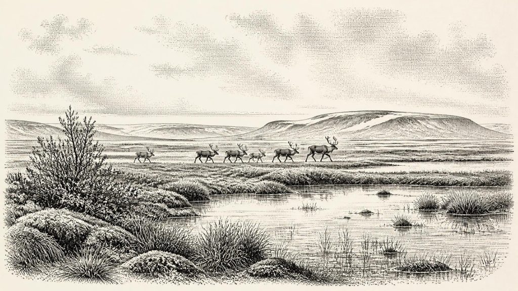
Thirty-one thousand five hundred and eighty-three BCE is a label within Marine Isotope Stage 3, not a recoverable Irish year. At Derryvree, Maguiresbridge, freshwater silts between glacial tills, radiocarbon dated to 36,900–31,700 calibrated BP, show that north-central Ireland intermittently supported cold tundra wetlands, vegetation and animals before ice advance. Comparable deposits demonstrate fluctuating climates. Castlepook Cave preserves remains of mammoth, reindeer, giant deer, predators and cold-adapted fauna, although its mixed deposits cannot represent one moment. A marked reindeer femur may indicate early human butchery, but lacks context. Evidence confirms a dynamic glacial-edge landscape, not permanent settlement or a land bridge.
Dateline
31,583 BCE is not a year that can be recovered in the historical sense. No Irish calendar, named community, ruler, battle or voyage can be assigned to it, and the surviving evidence cannot distinguish one season from the next at such depth in time. It is better treated as a modern point within a much wider Late Pleistocene interval: roughly 33,500 years before the conventional radiocarbon reference date of AD 1950, during Marine Isotope Stage 3 (MIS 3). Radiocarbon results of this age require calibration and normally yield broad probability ranges rather than an annual date. Ireland around this notional point is therefore known through sediments, fossil plants and insects, animal bones, cave deposits and the traces of ice, not through an event-by-event narrative.
A Window Between the Tills
The most illuminating Irish evidence belongs to Derryvree, near Maguiresbridge in County Fermanagh. Roadworks in 1969 cut through a drumlin and exposed freshwater silts and fine sands caught between two separate sheets of till, the unsorted sediment deposited by glacier ice. The sequence records a simple but profound order: ice had covered the locality; an ice-free freshwater environment later developed; then a renewed advance buried and preserved its deposits beneath further glacial sediment.
Organic material from the Derryvree freshwater beds produced the conventional radiocarbon determination Birm-166, 30,500 radiocarbon years BP, with a substantial uncertainty of +1,170 and −1,030 years. Calibrated with modern curves, this represents a broad calendar-age window rather than a point estimate, approximately 36,900–31,700 calibrated years BP, or about 34,950–29,750 BCE. The date label 31,583 BCE falls within that wide range, but it does not identify a moment when the deposit formed. Derryvree is consequently a valuable time-window relevant to this article, not a diary entry for the named year.
Its significance is geographical as well as chronological. The beds demonstrate that at least part of north-central Ireland could support standing or slow-moving freshwater, vegetation and animal life between episodes of glaciation. They disprove any simple picture of an island continuously hidden beneath ice throughout the Ice Age. They do not, however, prove that every region of Ireland was simultaneously ice-free, nor do they provide a national weather report. Conditions depended on the shifting margins, thickness and behaviour of ice, as well as elevation, drainage, exposure and proximity to the sea.
Open Ground, Wet Ground
Pollen, plant macrofossils, mosses and insect remains from Derryvree indicate a cold, periglacial landscape dominated by open vegetation. Sedges, grasses, herbs, mosses and low-growing shrubs were better adapted than woodland to the exposed climate. The term muskeg, used by investigators for this setting, conveys ground that was wet, peaty and moss-rich, with shallow pools and waterlogged margins. Frost action, seasonal thaw and unstable drainage would have shaped the surface. This was neither a featureless white desert nor a green version of modern Ireland: it was a varied tundra-like mosaic, with productive wet places set amid open, sparsely vegetated country.
Other northern Irish sequences, notably at Aghnadarragh near Lough Neagh and at Greenagho in Fermanagh, support the broader conclusion that MIS 3 contained major environmental fluctuations. Their deposits preserve evidence of cold, open landscapes and, at other points, milder interstadial conditions. The terminology used in older studies—such as “Middle Midlandian interstadial”—should not be mistaken for a uniformly warm episode. In this context, “interstadial” means an interval less severe or less extensively glaciated than the surrounding cold phases. Derryvree’s flora and fauna still describe an austere climate with strong seasonality.
This instability matters because the wider North Atlantic climate repeatedly changed during MIS 3. Ice margins could advance or withdraw; rivers could rework sediment; vegetation could expand into newly available ground and retreat again. Later glaciation destroyed or sealed much of the earlier evidence. The rarity of deposits such as Derryvree reflects this destructive history. What survives is biased towards caves, sheltered basins and sediments protected beneath later deposits, so absence of evidence in other places must not be read as proof that life was absent there.
The Castlepook Fauna
In the south, Castlepook Cave near Doneraile in north County Cork—historically called Mammoth Cave—provides Ireland’s principal fossil archive for roughly comparable Ice Age conditions. Its collections include remains attributed to woolly mammoth, reindeer, giant deer, brown bear, wolf, Arctic fox, mountain hare, lemmings and spotted hyaena. Individually and collectively, these animals show that Ireland could at times sustain a strikingly different fauna from that of the modern island. Reindeer, lemmings and Arctic fox point towards cold, open habitats; mammoth and giant deer towards extensive grazing landscapes; wolves and hyaenas towards a food web in which predators and scavengers competed for large carcasses.
Yet Castlepook cannot be treated as a photograph of one Irish valley in 31,583 BCE. Its bones accumulated over long spans of time, and not every species need have lived there in the same century, season or climate phase. A cave can be a carnivore den, a shelter, a trap, a drainage route and a sediment store. Hyaenas may drag prey into chambers; water can move bones; animals can die in fissures; collapse and early excavations can disturb relationships between finds. Much of the material was recovered before present-day standards of stratigraphic recording and taphonomic analysis. The cave is an extraordinary archive, but one that must be read critically.
Radiocarbon reassessment of southern Irish MIS 3 fauna has strengthened the case that some of these animals reached Ireland well before the Last Glacial Maximum. The major maximum of the last British–Irish Ice Sheet came later, broadly within the period around 26,500–19,000 years ago. Around the horizon considered here, the island was instead approaching a more extensive phase of glaciation, while retaining, in some places and intervals, habitats capable of supporting cold-adapted mammals. This was a changing frontier landscape, not an unchanging frozen island.
A Reindeer Bone and a Careful Claim
A reindeer femur from Castlepook has made this period especially important for the question of Ireland’s first people. Public heritage material and reporting have described the specimen as about 33,000 years old and carrying a deep mark interpreted by zooarchaeologist Ruth Carden as consistent with cutting or chopping by a sharp stone tool on fresh bone. If that interpretation is confirmed, it may be evidence that Upper Palaeolithic people processed a reindeer in Ireland during the wider period represented by this article.
The qualification is essential. The specimen came from an older cave collection, not a modern excavation of an intact occupation floor. No securely associated hearth, dwelling, stone-tool assemblage, burial, human bone or repeated food-processing deposit of comparable age has been published from Castlepook. A radiocarbon result dates the death of the animal, not automatically the moment a mark was made, the site of killing or the duration of a human visit. Nor can one marked bone identify the maker, establish a route into Ireland or demonstrate that a resident population existed.
The best-established evidence for a human incursion into Ireland remains much later: cut-marked brown-bear bones from Alice and Gwendoline Cave in County Clare, including a patella dated to approximately 12,810–12,590 calibrated years BP. The Castlepook femur may push the story back dramatically, but it remains a more limited and less securely contextualised clue. Responsible history must preserve the distinction between a possible episode of Ice Age butchery and proof of permanent settlement.
People Without a Recorded Society
If people did reach Ireland around this broad horizon, they were probably highly mobile hunter-gatherers, comparable in general lifeways—not demonstrably in identity—to Upper Palaeolithic groups elsewhere in north-west Europe. Such communities used stone technology, possessed detailed knowledge of animal behaviour and seasonal terrain, and maintained social connections across wide areas. A short visit to exploit a carcass, follow game or explore available ground is plausible. A named tribe, language, clothing style, shelter type, family structure or ritual practice in Ireland is not recoverable from the evidence.
There is no evidence here for political institutions, leaders, diplomacy, organised warfare, territorial states or formal alliances. Nor is there evidence for farming, livestock, pottery, metalworking, permanent fields, markets or trade networks within Ireland. If human activity occurred, its economy would have depended on wild resources and immediate practical knowledge: animal flesh, fat, hide, sinew, bone, antler, stone and perhaps plant foods. Those are reasonable inferences from Upper Palaeolithic subsistence elsewhere; they cannot be claimed as excavated facts for Castlepook.
Religion, art and learning are equally beyond direct reach. Upper Palaeolithic Europe contains evidence for ornament, image-making and complex symbolic activity, but none can presently be tied to Ireland at this date. The absence of Irish cave art, burials or ornaments of comparable antiquity is meaningful as an archaeological limitation, not proof that visitors lacked ideas, customs or beliefs. Deep-time archaeology often preserves the hardest materials and loses the social worlds that gave them meaning.
An Island in Motion
Ireland’s physical geography was also unlike that of today. Global sea level was lower during the Ice Age because water was stored in continental ice sheets, exposing parts of the surrounding shelf. But lower sea level must not be simplified into a guaranteed land bridge from Britain or the European mainland. The Irish Sea basin contains deep channels, while coasts, glaciers and water bodies changed repeatedly. Whether a particular crossing was possible depended on the exact phase, route and conditions. The Irish evidence does not allow a confident reconstruction of how animals, much less people, arrived.
The central development relevant to 31,583 BCE is therefore not political but environmental: Ireland included, at least intermittently, ice-free tundra and wetland landscapes before later ice expansion transformed them. Derryvree’s silts preserve their plants, insects and water; Castlepook’s caves retain traces of their animals; one reindeer femur raises the possibility of a human encounter. Together they reveal a precarious but living Irish world at the glacial edge. They do not supply a recoverable year, but they do show why this broad interval deserves a place in Ireland’s history.
Primary Sources
- A Middle Midlandian Freshwater Series at Derryvree, Maguiresbridge, County Fermanagh, Northern Ireland
- Quaternary Deposits and Glacial Stratigraphy in Ireland
- The Irish Quaternary Fauna Project
- Figure 6.— The Subdivision of the Quaternary Period in Ireland
- Aghnadarragh
- Occurrence of Mammalia Relicts at Site Castlepook Cave
- Castlepook Cave: Cork County Geological Site Report
- Heritage Artefacts of County Cork
- Archaeological Heritage of County Cork
- Europe and the County of Cork: A Heritage Perspective
- Prehistoric Details
- First Evidence of a Late Upper Palaeolithic Human Presence in Ireland
- First Evidence of a Late Upper Palaeolithic Human Presence in Ireland
- The Archaeology of Caves in Ireland
- New Insights on the Fauna of Ireland's Younger Dryas and Early Holocene from Alice & Gwendoline Cave
- Ireland: Submerged Prehistoric Sites and Landscapes
- The IntCal20 Northern Hemisphere Radiocarbon Age Calibration Curve (0–55 kcal BP)
- Growth and Retreat of the Last British–Irish Ice Sheet, 31,000 to 15,000 Years Ago: The BRITICE-CHRONO Reconstruction
- Timing and Pace of Ice-Sheet Withdrawal Across the Marine–Terrestrial Transition West of Ireland During the Last Glaciation
- The Timing and Magnitude of the British–Irish Ice Sheet Between Marine Isotope Stages 5d and 2
- A 10Be-Dated Record of Glacial Retreat in Connemara, Ireland, Following the Last Glacial Maximum and Implications for Regional Climate
- Dimensions and Chronology of the Last Ice Sheet in Western Ireland
- 2022:564 – Castlepook Cave, Castlepook South, Cork
- Castlepook Caves