
Bogbean Under the Drumlin31204 BCE
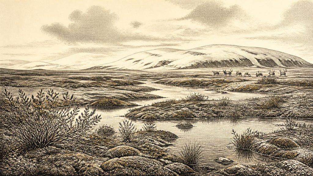
Around 31,204 BCE, Ireland’s evidence is environmental rather than historical. Derryvree, County Fermanagh, preserves a wetland deposit between glacial tills, dating broadly to late Marine Isotope Stage 3. Its plants and invertebrates indicate treeless, periglacial tundra with freshwater pools, bogbean and seasonally thawed ground. Castlepook Cave, County Cork, contains time-averaged remains of reindeer, mammoth, giant deer, carnivores and other cold-adapted animals, demonstrating ecological links with north-west Europe. A marked reindeer bone may record Upper Palaeolithic butchery, but cannot prove settlement. Before the Last Glacial Maximum, Ireland experienced fluctuating ice extent; evidence remains fragmentary, uncertain and regionally variable throughout this period.
Dateline
Time Beyond a Calendar
The label 31,204 BCE is useful only as a modern point on a very long timescale. It cannot identify an Irish year in the historical sense: no calendar, written testimony, named community or dated event survives from this depth of prehistory. In the conventional system that counts years before AD 1950, it lies roughly 33,150 calendar years before present, during the Late Pleistocene and Marine Isotope Stage 3. Even that conversion must not imply false precision. Radiocarbon determinations from this age need calibration, have substantial statistical ranges, and usually date an organism’s death or the formation of a deposit rather than an episode that can be fixed to a season, generation or numbered year.
The most relevant Irish evidence is therefore environmental and palaeontological rather than historical. It comes chiefly from a rare organic deposit at Derryvree, near Maguiresbridge in County Fermanagh, and from the rich but complicated bone assemblage in Castlepook Cave near Doneraile, County Cork. Together they show that Ireland was not simply an empty, uniformly ice-covered place before the Last Glacial Maximum. They do not provide a narrative of a particular year, nor do they demonstrate a permanent human population.
A Wetland Between Ice Advances
Derryvree is the closest important archive to this date. Road works in 1969 cut through a drumlin and exposed fine sands, silts and organic mud between two tills: unsorted material laid down directly by glacier ice. The sequence matters more than any single measurement. The lower till records an earlier incursion of ice. Above it, freshwater and wet-ground sediments accumulated during a locally ice-free interval. A later advance then sealed the wetland below another till. That burial preserved a small fragment of a landscape which later glaciation otherwise heavily reworked or destroyed.
The key determination, BIRM-166, gave an age of about 30,500 radiocarbon years BP, with an uncertainty of around 1,100 years. Published calibration and later regional modelling place the Derryvree evidence broadly within late MIS 3, with estimates spanning roughly 36,900–31,700 calibrated years BP and a modelled central age around 33,500 years ago. The modern date 31,204 BCE falls inside that broad frame. It cannot be assigned to a particular layer, plant, animal or moment within the deposit. This distinction is essential: Derryvree illuminates conditions over a long interval, not a single day in an ancient Irish calendar.
Treeless Water and Frozen Ground
The plant and invertebrate evidence from Derryvree indicates an open, treeless tundra or muskeg landscape under periglacial conditions. Mosses, sedges, dwarf willow, clubmoss and aquatic or wetland plants, including bogbean, point to pools, saturated ground and shallow freshwater amid cold open country. The evidence is not for a modern Irish bog, still less for a forested countryside. It represents a harsh but living mosaic: standing water and reed-fringed hollows, damp ground in sheltered places, sparse herb-rich surfaces and soils repeatedly affected by freezing and thawing.
Such a landscape would have changed strongly with season and with longer climatic oscillations. Winter cold, snow cover, frost-shattered ground and short growing seasons probably constrained plant productivity, while the summer thaw created wet patches capable of supporting insects, small animals and grazing mammals. The record demonstrates that conditions in at least part of Fermanagh could support freshwater life during this interval. It does not prove that every region of Ireland had the same climate or vegetation. Ireland’s relief, proximity to changing ice margins and the influence of the Atlantic ensured marked regional variation.
The Castlepook Animal World
Far to the south, Castlepook Cave preserves evidence for a broader Late Pleistocene fauna. Its collections include remains attributed to reindeer, woolly mammoth, giant deer, brown bear, wolf, fox, mountain hare, stoat, Arctic and Norway lemmings, and spotted hyaena. This assemblage is among the most important indications that cold-stage Ireland could be reached by large grazing animals, carnivores and scavengers. Reindeer and lemmings fit well with open cold habitats; mammoth and giant deer imply that, at least at some times, there were extensive enough feeding grounds to support large herbivores.
Yet Castlepook must be read cautiously. It is a cave archive, not a neatly sealed snapshot of one local ecosystem. Animals may have died in fissures, carnivores may have dragged bones underground, water may have moved material, and deposits were disturbed by both natural processes and early excavations. The bones also derive from more than one episode over a long span. A species represented in the cave was present in Pleistocene Ireland at some point; this does not establish that all listed species encountered one another, nor that they occupied the Doneraile landscape in 31,204 BCE.
The cave’s spotted hyaena remains are particularly revealing. Hyaenas could accumulate bone in dens and scavenge carcasses left by other predators, disease, accident or human activity. Their presence should not be turned into a dramatic scene of constant pursuit. It does, however, confirm that Ireland’s late-Pleistocene food webs sometimes included powerful carnivores as well as large herbivores. The country was ecologically connected to the wider north-west European world, although the exact routes, timing and frequency of animal movement remain debated.
A Possible Human Trace
One Castlepook object bears directly on the question of people: a reindeer femur fragment with a deep linear mark interpreted by zooarchaeologist Ruth Carden as damage made by a sharp stone tool during butchery. The bone has been publicly described as about 33,000 years old and County Cork heritage material places it broadly around 31,000 BC. If the mark is confirmed as anthropogenic, it would indicate that people processed a reindeer in Ireland during the Upper Palaeolithic, vastly earlier than the formerly accepted evidence for human activity on the island.
That is an important possibility, but not evidence for a settled society. The bone originated in an older cave collection rather than a modern excavation that recovered it with an associated hearth, stone-tool assemblage, floor surface, shelter, repeated refuse deposits or human remains. Its radiocarbon age dates the reindeer, not automatically the mark or the place where the carcass was butchered. Comparative analysis must distinguish cuts from damage caused by carnivores, trampling, sediment movement, weathering and breakage. For now, the responsible conclusion is that a brief human visit or processing episode is plausible, while continuous occupation and colonisation remain unproven.
Society Beyond Recovery
There is no evidence from Ireland at this date for political institutions, diplomacy, territorial leadership, warfare, formal religion, artistic traditions or systems of learning. Nor can archaeology recover family structures, language or beliefs from the Derryvree wetland and Castlepook bones. It would be misleading to supply them by analogy with later peoples. If humans did reach Ireland, they were likely highly mobile hunter-gatherers operating in the wider Upper Palaeolithic world of north-west Europe; that is an interpretation based on contemporary continental evidence, not a demonstrated description of an Irish community.
The same restraint applies to economy and trade. No Irish evidence establishes exchange networks, boats, regular crossings or a durable land route at this time. Lower sea levels changed coastlines and exposed continental-shelf land, but did not necessarily create a simple, permanent dry crossing between Ireland, Britain and mainland Europe. Ice margins and sea routes were dynamic. Animal dispersal and the possible marked reindeer bone show that access was possible at some stage; they do not reveal how often people travelled, what they carried, or whether they returned.
Approaching Greater Glaciation
This interval preceded the Last Glacial Maximum, when the British–Irish Ice Sheet later expanded much more extensively, broadly between about 26,500 and 19,000 years ago. The future ice advance would scour, bury and rearrange large areas of the island, helping explain why so little early evidence survives. Derryvree’s upper till records that return of ice in its own locality. The preserved wetland is therefore doubly valuable: it records a biologically active cold landscape and shows that Ireland’s glacial history was episodic rather than a single uninterrupted freeze.
For 31,204 BCE, then, the clearest Irish story is not of kings, battles or monuments. It is of a cold, open island landscape in flux: freshwater hollows and bogbean beneath Fermanagh’s later drumlins; large mammals and carnivores known from a Cork cave; and a single marked reindeer bone that may mark a fleeting human encounter. The evidence is fragmentary, time-averaged and often uncertain. Properly understood, that uncertainty is not a weakness in Ireland’s deep history, but the central fact of it.
Primary Sources
- The Exploration of Castlepook Cave, County Cork
- A Middle Midlandian Freshwater Series at Derryvree, Maguiresbridge, County Fermanagh, Northern Ireland
- The Irish Quaternary Fauna Project
- Irish Pleistocene Biostratigraphy
- The Quaternary of Ireland: A Field Guide
- Exploring Controls of the Early and Stepped Deglaciation on the Western Margin of the British-Irish Ice Sheet
- Oscillating Retreat of the Last British-Irish Ice Sheet on the Continental Shelf Offshore Galway Bay, Western Ireland
- Dimensions and Chronology of the Last Ice Sheet in Western Ireland
- Trimlines, Blockfields and the Vertical Extent of the Last Ice Sheet in Southern Ireland
- Character of Advance and Retreat of the Southwest Sector of the British-Irish Ice Sheet During the Last Glaciation
- Growth and Retreat of the Last British-Irish Ice Sheet, 31,000 to 15,000 Years Ago: the BRITICE-CHRONO Reconstruction
- Britain and Ireland: Glacial Landforms from the Last Glacial Maximum
- The IntCal20 Northern Hemisphere Radiocarbon Age Calibration Curve (0–55 cal kBP)
- IntCal Publications
- Occurrence of Mammalia Relicts at Site Castlepook Cave
- Heritage Artefacts of County Cork
- Archaeology Research Excavation Grant Report: Castlepook Cave Project
- New Insights on the Fauna of Ireland's Younger Dryas and Early Holocene from Alice & Gwendoline Cave
- Introduction to the Late Quaternary and Holocene of Northern Ireland
- Sedimentary Ancient DNA Reveals Late Pleistocene Faunal Connectivity Between Ireland and Eurasia
