
Maguirebridge’s Periglacial Pools31209 BCE
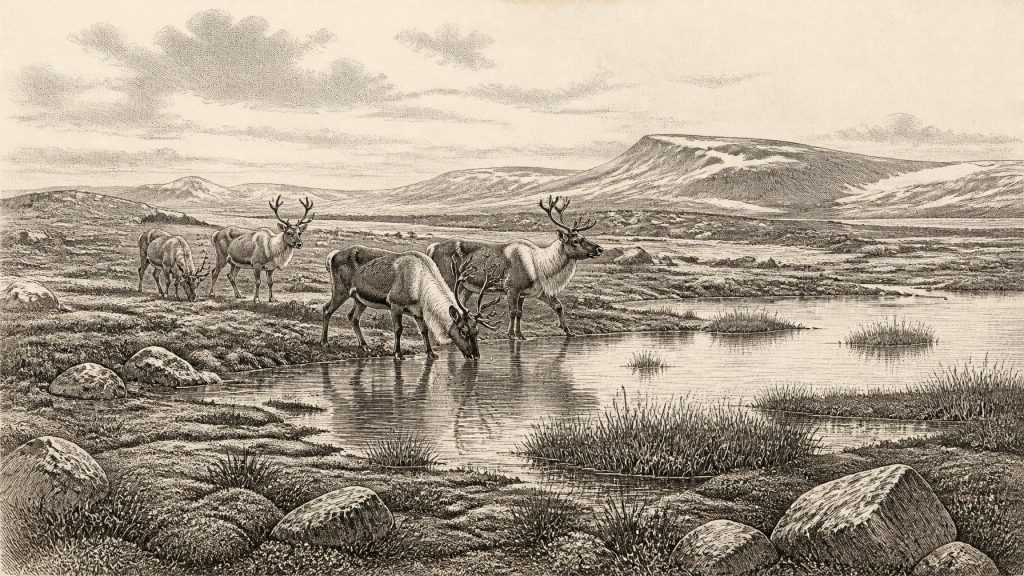
About 31,209 BCE, Ireland experienced a fluctuating Late Pleistocene climate rather than a precisely datable event. At Derryvree near Maguiresbridge, freshwater sediments between glacial tills, dated broadly to 36,900–31,700 years ago, show a local ice-free interval with pools, sedges, mosses, bogbean and open tundra vegetation. Castlepook Cave preserves remains of mammoth, reindeer, giant deer, predators and other cold-adapted animals, though not from one moment. A marked reindeer bone may indicate brief human butchery, but no secure settlement evidence exists. Ireland’s changing ice, lowered seas and later glaciation fragmented this record, preserving chiefly environmental history rather than political or social narratives.
Dateline
The label 31,209 BCE gives an appearance of precision that the evidence cannot sustain. Nobody in Ireland kept a calendar at this depth in time, and archaeology cannot recover an event, person or community from one particular modern-style year. The date is best understood as a point within the Late Pleistocene, roughly 33,159 years before the conventional radiocarbon baseline of 1950, during Marine Isotope Stage 3 of the last Ice Age. The most responsible account is therefore built from calibrated ranges, fossils and sediments rather than a year-by-year narrative in the ordinary sense.
The strongest Irish environmental evidence relevant to this broad moment comes from Derryvree, near Maguiresbridge in County Fermanagh. In 1969, roadworks cut through a drumlin and exposed freshwater silts and fine sands, including organic material, lying between two separate layers of glacial till. The sequence is unusually revealing: ice had deposited the lower till; an ice-free interval then allowed water, mud, plants and small animals to accumulate; later ice or glacier-fed deposition covered the site with upper till. A radiocarbon determination, Birm-166, gave 30,500 radiocarbon years before present, with a large error range. When calibrated, the deposit has been placed broadly at about 36,900–31,700 calibrated years before present. The notional year 31,209 BCE falls inside that wide window, but it cannot be assigned to a particular sediment layer, season or pool.
An Ireland Between Ice Advances
Derryvree shows that at least part of Ireland was not continuously buried beneath ice during this portion of the last glacial cycle. It does not show that the whole island was ice-free, nor that conditions in Fermanagh precisely matched those in Cork, the western seaboard or the Irish Sea basin. The island’s glaciers repeatedly expanded, thinned and reorganised as the North Atlantic climate fluctuated. The Derryvree freshwater bed records one local opening between glacial episodes; the tills above and below it record the much larger instability of the period.
The broader trajectory matters. Reconstructions of the British–Irish Ice Sheet indicate major growth after this interval, with extensive ice advancing across Ireland before the overall maximum of the Last Glacial Maximum, conventionally placed around 26,000–20,000 years ago. Around 31,209 BCE, then, Ireland was not yet the uniformly ice-dominated landscape often imagined under the phrase “Ice Age”. It was a changing northern land, where locally open ground, wet hollows and running water existed within a wider world becoming increasingly cold and glacial.
Mosses, Sedges and Bogbean
The Derryvree fossils give that landscape texture. Plant macrofossils, pollen and insect remains point to an open tundra or muskeg environment rather than closed woodland. Grasses, sedges, herbs, mosses, low shrubs and cold-adapted plants could grow where soil, moisture and the brief summer season allowed. A particularly evocative find is a seed of bogbean, Menyanthes trifoliata, a plant associated with shallow freshwater and wet margins. Its survival in the deposit is direct evidence for pond or marsh habitat; it does not, however, justify imagining a continuous bog stretching across the county.
The treelessness inferred from the assemblage is important. A low, patchy cover of vegetation would have left much ground exposed to frost, wind and seasonal thaw. In sheltered or wet places, vegetation may have been richer; on drier ground, sparse herbs and grasses probably alternated with bare mineral soil and frost-shattered stones. Snow cover, frozen ground and meltwater would have varied sharply through the year. This was not simply an empty white wilderness. It was a mosaic of cold freshwater, wet sedge ground and open land, productive enough in places to support insects and grazing mammals, but far removed from the wooded and intensively settled Ireland of later millennia.
The Castlepook Animal World
For larger animals, the key Irish archive lies far to the south-west at Castlepook Cave, near Doneraile in County Cork, also known as Mammoth Cave. Excavations and museum collections from this limestone cave have produced one of Ireland’s richest Pleistocene faunal assemblages. Its recorded species include woolly mammoth, giant deer, reindeer, brown bear, wolf, Arctic fox, mountain hare, lemmings and spotted hyaena. Not all specimens were deposited at the same moment: the cave accumulated remains across a long span, and many were recovered during early excavations with incomplete modern-style stratigraphic recording. Each bone must therefore be dated and interpreted on its own merits.
Even with that caution, Castlepook establishes that a diverse cold-climate fauna reached Ireland during the broader period before the Last Glacial Maximum. Reindeer were adapted to open, northern environments; lemmings and Arctic fox point in the same climatic direction. Mammoth, giant deer, wolves and hyaenas indicate a food web with large herbivores, predators and scavengers. Caves were not necessarily ordinary animal homes. They could act as dens, traps, sheltering places, carnivore lairs or repositories into which bones were dragged, washed or disturbed. The animal list illuminates habitats and possible movements, not a neat census of a single Irish valley in one year.
The Human Question
Castlepook also raises the most intriguing and unsettled question about Ireland at this date: were people present? A reindeer femur from the cave has been reported as carrying a deep mark consistent with fresh-bone processing by a sharp stone tool, and public interpretation has associated the animal with an age of around 33,000 years ago. If that reading proves secure, it would indicate a human encounter with a reindeer carcass in Ireland vastly earlier than the island’s well-established Mesolithic settlement. It would be evidence for an episode of butchery, not proof of a resident population.
The distinction is essential. No securely associated stone-tool assemblage, hearth, dwelling, burial, repeated occupation surface or human skeletal remains of comparable age has been found in Ireland. Nor does one marked bone identify the people involved, their route, language, kinship, beliefs or length of stay. Cave collections are especially difficult because bones of different ages can be mixed by animals, water, collapse and earlier excavation. Radiocarbon dating establishes the age of sampled organic material within a statistical range; microscopic assessment of a surface mark addresses a different question, namely whether an implement or natural process made it.
Accordingly, the best current interpretation is deliberately modest. Ireland may have received brief visits by Upper Palaeolithic hunter-gatherers during favourable intervals, perhaps connected to animal movements or opportunistic use of carcasses. That remains a possibility under investigation, not an established story of colonisation. The earliest published evidence generally treated as secure for human activity on the island is much later: cut marks on a brown-bear kneecap from Alice and Gwendoline Cave, County Clare, dated to roughly 12,800–12,600 calibrated years before present.
No Polities, But Real Ecologies
There is no evidential basis for political affairs, diplomacy, named groups, warfare, chiefs, religion or formal learning in Ireland around this point. There were no known farms, villages, monuments, cultivated fields, metal objects, pottery traditions or written symbols. It would be misleading to manufacture them merely to fill modern historical categories. If people visited, their social world must be sought in the wider Upper Palaeolithic record of north-west Europe, not assumed from Irish finds that do not exist.
Nor can economy and trade be described in their later sense. The evidence instead concerns subsistence possibilities: animal carcasses, freshwater margins, seasonal plant growth and the practical value of sheltered limestone caves. A small human party, if present, would have relied on portable knowledge, clothing, fire-making and stone technology, but no Irish assemblage from this period demonstrates those practices directly. The defensible statement is that the landscape could offer resources, while the archaeological record has not yet demonstrated how, or whether, people organised their use of them.
A Landscape With No Recorded Memory
Modern Ireland’s familiar coastlines did not exist in the same form. Much water was locked into global ice sheets, lowering sea level, while local ice and land movements altered drainage and shorelines. Yet low sea level alone does not prove a simple dry-land route to Ireland at this specific date. The changing Irish Sea basin, ice margins and possible crossings require local reconstruction, and evidence for any human journey remains absent. The island’s later separation and the destructive force of subsequent glaciation are central reasons why its early record is so fragmentary.
The most important development around the notional date 31,209 BCE was therefore environmental, not political: Ireland contained cold but locally varied ice-age habitats during an interval before the great expansion of the last ice sheet. Derryvree’s freshwater sediments preserve sedges, mosses and bogbean beneath a later drumlin; Castlepook’s caves preserve traces of a lost animal world and a tantalising but unconfirmed human story. Together they provide a rigorous historical picture: not a dated event, but a precarious landscape of pools, tundra vegetation and roaming mammals, later transformed and partly erased by ice.
Primary Sources
- A Middle Midlandian Freshwater Series at Derryvree, Maguiresbridge, County Fermanagh, Northern Ireland
- The Irish Quaternary Fauna Project
- Growth and Retreat of the Last British–Irish Ice Sheet, 31,000 to 15,000 Years Ago: the BRITICE-CHRONO Reconstruction
- Trimlines, Blockfields and the Vertical Extent of the Last Ice Sheet in Southern Ireland
- Late Pleistocene Chronostratigraphy and Ice Sheet Limits, Southern Ireland
- The Deglaciation of the Western Sector of the Irish Ice Sheet From the Inner Continental Shelf to its Terrestrial Margin
- Castlepook Cave: County Geological Site Report
- Heritage Artefacts of County Cork
- Spotted Hyena Skull
- Palaeoecology
- Soils of County Waterford
- The Mesolithic in Ireland: When Was It?
- New Insights on the Fauna of Ireland’s Younger Dryas and Early Holocene from Alice & Gwendoline Cave
- New Insights on the Fauna of Ireland’s Younger Dryas and Early Holocene from Alice & Gwendoline Cave
- Castlepook Cave, Castlepook South, County Cork
- Occurrence of Mammalia Relicts at Site Castlepook Cave
- Menyanthes trifoliata
- Landscapes and Environments of the Last Glacial-Interglacial Transition: A Time of Amazingly Rapid Change in Ireland
- The IntCal20 Northern Hemisphere Radiocarbon Age Calibration Curve (0–55 cal kBP)
- Lateglacial Vegetation and Environment in Ireland: First Results From Four Western Sites