Fermanagh’s Sedgebed Interval30733 BCE
Labelled 30,733 BCE, this interval lies within unstable MIS 3 and cannot be resolved to a single Irish year. At Derryvree, County Fermanagh, freshwater silts between glacial tills, dated broadly to c.36,900–31,700 calibrated years BP, record an ice-free wetland between advances. Sedges, mosses, aquatic plants, insects and Arctic-alpine species indicate cold, open, largely treeless periglacial terrain. Climate fluctuated sharply, while Ireland’s ice extent, coastlines and possible access routes remain uncertain. Castlepook Cave preserves MIS 3 fauna including mammoth, reindeer and predators, but not a census. A modified reindeer bone may suggest human activity, yet no evidence demonstrates settlement or society.
Dateline
30,733 BCE is not a recoverable year in Ireland’s past. It is a modern calendar label for a point roughly 32,682 calibrated years before AD 1950, within the Late Pleistocene and Marine Isotope Stage 3 (MIS 3), a climatically unstable part of the last Ice Age. No written dates, named communities, settlements or individual events survive from Ireland at this depth of time. The evidence cannot distinguish one year, season or generation from another. It consists instead of stratified sediments, fossil plants and animals, glacial landforms, and laboratory dates expressed as broad statistical ranges.
The most useful Irish evidence close to this notional date comes from Derryvree, near Maguiresbridge in County Fermanagh. Its importance lies not in a human monument or artefact but in an accidental survival: a freshwater deposit buried between two layers of glacial till. This small archive permits a responsible account of an Irish environment during part of MIS 3. It does not license a conventional narrative of rulers, battles or a settled people in 30,733 BCE.
A Date Within a Range
At Derryvree, roadworks exposed fine sands, organic silts and freshwater deposits lying between lower and upper tills. Till is the unsorted mixture of clay, stones and other debris laid down directly by glacier ice. The sequence establishes a clear order of events. Ice had first affected the locality; subsequently, water and organic sediment accumulated in an ice-free hollow; later glacier ice or ice-derived sediment covered and sealed that freshwater world.
Organic material from the intervening beds produced the radiocarbon determination BIRM-166, conventionally reported as 30,500 radiocarbon years before present, with a substantial uncertainty. A radiocarbon age is not a calendar age. Atmospheric carbon-14 has varied through time, so laboratory results must be calibrated against independently dated records. Modern calibration places the Derryvree material broadly at about 36,900–31,700 calibrated years before present; later modelling has centred the result at about 33,500 ± 1,200 calibrated years before present. The requested date falls within the wider calibrated span, but this overlap must not be overstated. It cannot show that a particular pool, plant or animal existed in the calendar year 30,733 BCE.
The range is itself historically important. It demonstrates why calendar precision is unavailable here. The Derryvree organic beds accumulated over time, the original measurement has an error margin, and calibration produces probabilities rather than an annual timetable. Ireland at this date is therefore best approached through a broad environmental interval, not an imagined dated episode.
Freshwater Between Ice Advances
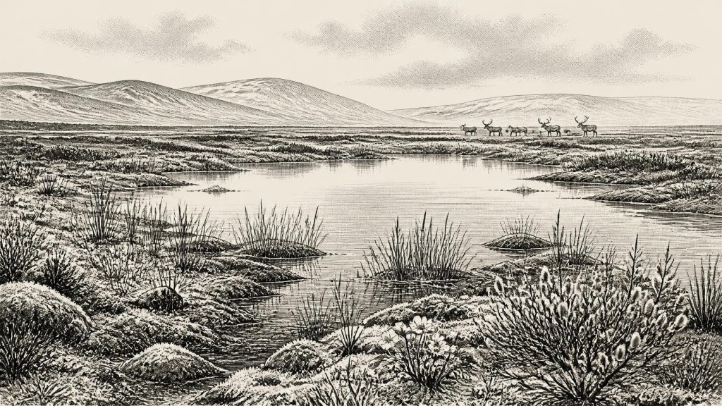
Derryvree provides firm local evidence that part of Fermanagh supported freshwater and vegetation between glacial episodes. Its plant and insect remains indicate cold, open and largely treeless terrain. Mosses, sedges and grasses were significant. The recorded flora includes bogbean, alternate water-milfoil, mountain-avens, dwarf willow and lesser clubmoss. Some of these plants point directly to shallow or slow-moving freshwater and wet ground; others are associated with exposed, cold or Arctic-alpine conditions. Fossil insects reinforce the picture of a northern, periglacial environment.
“Periglacial” is a useful term, but it needs care. It describes terrain profoundly influenced by cold, repeated freezing and thawing, seasonal water movement and proximity to glaciers. It does not mean that the Derryvree basin was frozen solid throughout the year, nor that it lay under ice while its organic silts were forming. The deposit instead records a functioning wetland: water carrying fine sediment, plants rooting along saturated margins, insects occupying aquatic and terrestrial niches, and decaying organic matter being preserved in mud.
This was not later Ireland’s wooded landscape of oak, hazel and pasture. There is no basis for projecting forests, cultivated fields, hedges or familiar bogland on to this period. A more supportable reconstruction is of a low-lying basin with shallow water, sedge beds, mossy margins, scattered herbs and low shrubs, exposed mineral ground and harsh winters. Short growing seasons could nonetheless sustain a varied small-scale ecosystem. The evidence is direct for the organisms and sediments at Derryvree; the wider image of a tundra-like wetland is an ecological interpretation based on them.
An Unstable Atlantic Edge
The Derryvree deposit belongs to MIS 3, when climate in the North Atlantic region changed sharply on millennial and sometimes shorter timescales. Greenland ice cores record repeated swings between colder stadials and warmer interstadials. Irish cave calcite from Crag Cave in County Kerry offers independent evidence that liquid water could periodically circulate through shallow caves during MIS 3, implying episodes of climatic amelioration. Derryvree’s calibrated date range has been correlated only approximately with several Greenland interstadials, rather than with one securely defined event.
For 30,733 BCE, it would be misleading to draw a single all-Ireland map of ice cover. The freshwater deposits prove that Derryvree was locally free of overriding ice when they formed, but they do not show that every Irish valley, coast and upland was ice-free at the same moment. The surviving record is patchy because subsequent glaciation eroded, moved or buried much of what had existed before. The later expansion of the British–Irish Ice Sheet was the largest regional transformation in prospect: its maximum extent belongs considerably later, broadly around 27,000–23,000 calibrated years before present in Irish offshore reconstructions.
Sea level was lower globally than today, altering the surrounding continental shelf and coastlines. Yet lower sea level alone does not prove a permanent dry land bridge to Britain or continental Europe. Around Ireland, changing ice masses also altered relative sea level by depressing and later releasing the land. Routes for animals or people would have depended on shifting combinations of sea, exposed shelf, ice margin, habitat and season. The exact geography of access in this particular year is not known.
Castlepook’s Animal World
County Cork provides a second, very different window on broad MIS 3 Ireland. Castlepook Cave near Doneraile, also called Mammoth Cave, has yielded one of the island’s major Pleistocene animal collections. Its remains include woolly mammoth, reindeer, giant deer, brown bear, wolf, Arctic fox, mountain hare, lemmings and spotted hyaena. Such animals indicate that Ireland was, at least during overlapping phases of the period, connected ecologically to the wider north-west European cold-stage world.
The cave cannot, however, be read as a single scene from 30,733 BCE. Its bones were accumulated through more than one process: animal deaths, carnivore activity, scavenging, water movement and sediment disturbance. Much was excavated in the early twentieth century, before modern standards of context recording. Recent radiocarbon re-dating has shown that several earlier determinations for southern Irish cave fauna were too young, in some cases by thousands of radiocarbon years. The revised work places part of the Castlepook fauna firmly in MIS 3 and suggests that giant deer and spotted hyaena may have disappeared locally before the Last Glacial Maximum.
Reindeer and mammoth should therefore be treated as evidence for broad environmental possibilities, not as a precise census. Reindeer favour open, cold country; mammoth, giant deer and carnivores imply food webs unlike those of historic Ireland. But the cave material does not prove that every listed species lived together in one Cork valley, in one season or even in the same millennium. Its greatest value is to establish that an older, richer Pleistocene fauna had reached Ireland before later ice-sheet activity reworked the landscape.
The Limited Question of People
Castlepook has also raised the possibility of an exceptionally early human visit. A reindeer femur from the cave has been reported as around 33,000 years old and bears a deep modification interpreted as a fresh-bone cut or chop made with a sharp stone edge during carcass processing. If both the human origin of the mark and its association with the animal’s death are sustained, it would be major evidence for Upper Palaeolithic activity in Ireland.
That conclusion remains limited. No securely associated hearth, stone-tool assemblage, dwelling, burial, repeated butchery floor or stratified campsite of this age has been published from Ireland. One modified bone cannot demonstrate permanent occupation, population size, language, ancestry, seasonal territory or a migration route. It is more responsible to say that brief human contact with an animal carcass is possible than to populate the island with a named hunting community. Comparisons with mobile Upper Palaeolithic hunter-gatherers elsewhere in Europe may help frame questions, but they are not direct evidence for Irish society.
No Polities, but Real History
Political affairs, diplomacy and organised conflict cannot be recovered for Ireland around this date. Nor is there evidence for farming, trade networks, metalworking, monuments, formal religion, art or institutions of learning. The absence of such evidence should not be disguised by invention. If people reached Ireland, they would have required practical knowledge of weather, animals, raw materials, shelter and movement through difficult country; that is a reasonable general inference, not a documented Irish social history.
The decisive development was environmental. At Derryvree, water, mosses, sedges and cold-adapted plants briefly made a living landscape between separate glacial advances. At Castlepook, cave deposits retained traces of large herbivores and predators that once moved through open country. Across the following millennia, expanding ice would remodel drainage, terrain, habitats and the archaeological record itself. Ireland in 30,733 BCE was thus neither an empty abstraction nor a prehistoric nation awaiting history. It was a changing Atlantic-edge environment, known in fragments: a Fermanagh sedgebed, a Cork cave fauna, and a debated mark on reindeer bone.
Primary Sources
- A Middle Midlandian Freshwater Series at Derryvree, Maguiresbridge, County Fermanagh, Northern Ireland
- BSBI: Selaginella selaginoides
- BSBI: Dryas octopetala
- South Fermanagh: A Field Guide
- A Reconsideration of the Radiocarbon Dating of the Marine Isotope Stage 3 Fauna from Southern Ireland
- Episodic Speleothem Deposition Tracks the Terrestrial Impact of Millennial-Scale Last Glacial Climate Variability in SW Ireland
- Exploring Controls of the Early and Stepped Deglaciation on the Western Margin of the British Irish Ice Sheet
- Trimlines, Blockfields and the Vertical Extent of the Last Ice Sheet in Southern Ireland
- Dimensions and Chronology of the Last Ice Sheet in Western Ireland
- BRITICE Glacial Map, Version 2: A Map and GIS Database of Glacial Landforms of the Last British-Irish Ice Sheet
- A Stratigraphic Framework for Abrupt Climatic Changes During the Last Glacial Period Based on Three Synchronized Greenland Ice-Core Records
- The IntCal20 Northern Hemisphere Radiocarbon Age Calibration Curve (0–55 cal kBP)
- New Insights on the Fauna of Ireland's Younger Dryas and Early Holocene from Alice & Gwendoline Cave
- New Insights on the Fauna of Ireland's Younger Dryas and Early Holocene from Alice & Gwendoline Cave (PDF)
- Heritage Artefacts of County Cork
- An Island World? Hunter-Gatherers in Ireland
- Conserving Quaternary Geoheritage in Northern Ireland
- The Late Quaternary History of East-Central Ireland
- European Vegetation During Marine Oxygen Isotope Stage-3
- Spatio-Temporal Dynamics of Speleothem Growth and Glaciation in the British Isles
- The Geology of Ireland: Cenozoic, Tertiary and Quaternary
- Pleistocene Vertebrates in the British Isles
