

Maguirebridge Beneath Two Tills30621 BCE
30,621 BCE is a modern label within a broad calibrated Late Pleistocene range, not a recoverable Irish year. At Derryvree, County Fermanagh, organic wetland sediments between glacial tills indicate a local ice-free interval during Marine Isotope Stage 3. Plant and insect evidence reconstructs cold, open tundra wetlands, rather than forest or permanent snow. Castlepook Cave, County Cork, preserves remains of diverse cold-stage mammals, although its mixed deposits cannot place species together precisely. A cut-marked reindeer femur may indicate human butchery around 31,000 BCE, but does not prove settlement. Evidence reveals environmental change and possible human activity, while precluding social history.
Dateline
The label 30,621 BCE is a modern way of locating a point deep in prehistory, not a date known to anybody then living in Ireland. No Irish written record, calendar, settlement sequence or event can be assigned to that individual year. At this distance in time, even radiocarbon results need calibration and carry wide margins of uncertainty. The responsible subject is therefore Ireland during the later part of Marine Isotope Stage 3, rather than a recoverable twelve-month episode.
The nearest important Irish environmental archive is at Derryvree, close to Maguiresbridge in County Fermanagh. There, roadworks cut through a drumlin in 1969 and revealed organic silts and fine sands trapped between two deposits of glacial till. The organic material produced the radiocarbon determination BIRM-166, conventionally dated to about 30,500 ± 1,170 radiocarbon years before present. Modern calibration places this broad horizon approximately within 36,900–31,700 calibrated years before present, or roughly 34,950–29,750 BCE. The modern label 30,621 BCE falls within that wide range, but cannot be pinned to a particular layer, season, generation or event.
A Local Window, Not a Map
Derryvree’s sequence is powerful because of its order. A lower till shows that glacier ice had formerly crossed the site. Above it, freshwater and wetland sediments accumulated during an interval when ice was absent locally. An upper till shows that later glacial activity sealed the deposits. This is firm evidence for changing conditions at one Fermanagh locality. It is not proof that every part of Ireland was ice-free, equally hospitable or inhabited at the same time.
That distinction matters especially in an island whose older landscapes were repeatedly eroded, buried and rearranged by ice. The Late Pleistocene record is fragmentary by nature. A buried wetland can survive beneath till while nearby surfaces, possible campsites and riverbanks are removed altogether. Consequently, the evidence around this date illuminates climate, plants, animals and landforms better than it illuminates human social life.
The broader climatic setting was unstable. Marine Isotope Stage 3, broadly c. 59,500–24,000 years ago, contained abrupt North Atlantic shifts between colder stadials and comparatively milder interstadials. Ireland stood at the Atlantic edge of these changes. The age represented at Derryvree preceded the fullest expansion of the last British–Irish Ice Sheet, generally placed later, during the Last Glacial Maximum. Yet “before the maximum” must not be mistaken for warm, wooded or secure. This was an ice-age world of severe winters, short growing seasons, frost action and rapid environmental change.
Wet Tundra in Fermanagh
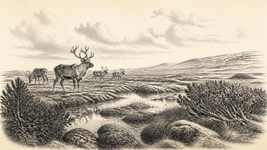
The Derryvree organic beds have been interpreted as an open, treeless muskeg or tundra-wetland landscape. Pollen was poorly preserved, but plant macrofossils, mosses and insect remains offer more particular evidence. Grasses and sedges occurred with juniper and herbaceous plants. Mosses, bogbean and water-milfoil indicate damp ground and freshwater margins; mountain-avens, dwarf willow and lesser clubmoss belong to the wider cold-adapted flora used to reconstruct the setting. Open pools, plant-rich shallows and mossy banks were therefore likely components of the local terrain.
This was not a blank expanse of permanent snow. In the favourable season, wetlands could support plants, insects and grazing animals, while shallow water collected sediment and organic debris. Nor should it be turned into a lush modern bog. The reconstructed environment implies cold, exposed ground, seasonal freezing and limited woody cover. Juniper may have grown in sheltered places, but no forest canopy is indicated. The visual character was probably a mosaic of low vegetation, wet hollows, raw mineral ground and periglacial surfaces.
At the scale of the island, regional difference is unavoidable. Fermanagh’s buried basin describes its own catchment. Uplands, coasts, limestone districts and areas nearer active ice would have differed in drainage, shelter and vegetation. Sea level was much lower than today, so shorelines lay beyond modern coasts in some places. However, the changing ice, sea and land configuration does not permit a confidently drawn land route for this precise date. Any movement between Ireland, Britain and continental Europe depended on conditions that varied over long periods, not on a single simple “land bridge”.
Castlepook’s Animal Evidence
In north County Cork, Castlepook Cave near Doneraile—also called Mammoth Cave—provides the most significant Irish animal assemblage relevant to this general period. Early twentieth-century excavation recovered a remarkable concentration of Pleistocene bones from its limestone galleries. Later dating and reassessment have shown both the value and the difficulty of this collection: cave deposits were affected by carnivores, water, sediment movement and antiquarian excavation, and many specimens were not recovered from modern, tightly controlled contexts.
Across its long accumulation, Castlepook has yielded remains attributed to woolly mammoth, reindeer, giant deer, brown bear, wolf, Arctic fox, lemming and spotted hyaena. These finds demonstrate that Ireland was reached by a much richer suite of cold-stage mammals than its later historic fauna suggests. They do not demonstrate that all these species grazed or hunted together in the same valley in 30,621 BCE. Individual bones can be separated by thousands of years, and revised radiocarbon methods have shown that some earlier determinations from Irish cave bone were too young.
Even so, the fauna gives the landscape ecological depth. Reindeer and large herbivores point to open ground capable of supporting grazing; hyaenas, wolves and bears speak to predation, scavenging and the use of caves as dens or refuges. Mammoth remains confirm that these enormous animals reached Ireland during the wider Late Pleistocene, not that a mammoth herd can be placed beside Derryvree at this date. Caves are archives of what entered them, often by forces other than people, rather than straightforward snapshots of the country outside.
A Contested Human Trace
A single reindeer femur from Castlepook gives this period exceptional importance for Irish human history. County Cork heritage material identifies it as a Palaeolithic bone of about 31,000 BCE and records zooarchaeologist Ruth Carden’s interpretation of a deep incision as a mark made with a sharp stone tool during butchery. If that reading is sustained, it suggests that people handled a reindeer in Ireland tens of millennia before the island’s better-established terminal Pleistocene evidence.
The claim requires care. The dated bone establishes the animal’s age, not an exact modern calendar year for cutting. The femur derives from an old cave collection, rather than a recently excavated and sealed occupation floor. No securely associated stone-tool assemblage, hearth, dwelling, burial, human remains or dense deposit of processing waste has yet demonstrated a Palaeolithic settlement at Castlepook. Nor can the bone tell us whether people killed the animal, encountered an already dead carcass, processed it elsewhere, visited only briefly, or returned.
It is therefore evidence for a possible action, not proof of a permanent population or a named first community. The appropriate comparison is with highly mobile Upper Palaeolithic groups elsewhere in north-west Europe, whose survival depended on intimate knowledge of seasonal animals, sheltered terrain, fuel, hides, stone and weather. Such comparisons can indicate what a short visit to Ireland might have entailed, but they cannot fill the Irish record with camps, families or customs for which no direct evidence survives.
What Cannot Yet Be Written
There were no Irish states, kingdoms, chiefs, borders or diplomatic relations that can responsibly be identified for this horizon. There is no evidence for warfare, organised political authority, trade networks, cultivated fields, livestock, monuments, formal burial grounds, writing, art or institutional religion in Ireland around this date. Silence on these subjects is not a judgement that people elsewhere lacked culture; it reflects the limits of evidence from Ireland itself.
Likewise, no economy can be described beyond the ecological possibilities suggested by the fauna and landscape. If humans did visit, subsistence would have involved the immediate acquisition and processing of animal and plant resources, but there is no excavated Irish assemblage from this date that permits a quantified diet, a trade commodity or a proven technology. The Castlepook femur is important precisely because it is so rare, not because it supports a detailed reconstruction of daily life.
The major development represented by 30,621 BCE is thus environmental and evidential. At Derryvree, a freshwater tundra wetland formed between episodes of glaciation; at Castlepook, cave deposits preserve traces of a diverse cold-stage animal world and a provocative possible sign of human butchery. Together they overturn any simple picture of an Ireland continuously entombed beneath ice. They also demand restraint: this was a changing Late Pleistocene landscape, known in broad calibrated ranges, not a historical year with recoverable events.
Primary Sources
- A Middle Midlandian freshwater series at Derryvree, Maguiresbridge, County Fermanagh, Northern Ireland
- Quaternary Deposits and Glacial Stratigraphy in Ireland
- Irish Pleistocene Biostratigraphy
- Palaeoecology
- The Subdivision of the Quaternary Period in Ireland
- The Late Quaternary History of East-Central Ireland
- The Irish Quaternary Fauna Project
- A Reconsideration of the Radiocarbon Dating of the Marine Isotope Stage 3 Fauna from Southern Ireland
- Castlepook Cave: County Geological Site Report
- The Exploration of Castlepook Cave, County Cork
- Occurrence of Mammalia Relicts at Site Castlepook Cave
- Heritage Artefacts of County Cork
- Castlepook Cave, County Cork, 2022
- New Insights on the Fauna of Ireland's Younger Dryas and Early Holocene from Alice & Gwendoline Cave
- Exploring Controls of the Early and Stepped Deglaciation on the Western Margin of the British-Irish Ice Sheet
- Growth and Retreat of the Last British-Irish Ice Sheet, 31,000 to 15,000 Years Ago: The BRITICE-CHRONO Reconstruction
- Pattern, Style and Timing of British-Irish Ice Sheet Advance and Retreat over the Last 45,000 Years
- The IntCal20 Northern Hemisphere Radiocarbon Age Calibration Curve (0–55 cal kBP)
- Fast and Slow Components of Interstadial Warming in the North Atlantic During the Last Glacial
- Introduction to the Late Quaternary and Holocene of Northern Ireland
- Radiocarbon Dates from the Oxford AMS System: Archaeometry Datelist 31