
Derryvree’s Moss and Meltwater31010 BCE
Around 31,010 BCE, Ireland’s history is reconstructed from environmental and archaeological evidence, not dated events. Derryvree, County Fermanagh, preserves freshwater wetland sediments between glacial tills, indicating cold, treeless, locally ice-free terrain with mosses, sedges, herbs and shallow pools during MIS 3. Crag Cave records episodic climatic improvement. Castlepook Cave, County Cork, contains a long-accumulated Ice Age fauna including mammoth, giant deer, reindeer, bear and hyaena, although species were not necessarily contemporary. Possible tool damage on one bone is inconclusive. No secure evidence exists for settlements, polities or sustained human occupation. Later ice buried or erased much of this fragmented record.
Dateline
31,010 BCE is a modern calendar label imposed on a world that did not use calendars, writing or recorded regnal years. It therefore cannot identify a dated Irish event, a named person or a particular day. In archaeological terms, it falls about 32,959 years before AD 1950, within the Late Pleistocene and Marine Isotope Stage 3 (MIS 3), a volatile interval of the last Ice Age. The most responsible account is not a conventional annual chronicle but a reconstruction from deposits, fossils and changing scientific methods. The strongest Irish environmental evidence relevant to this broad horizon comes from Derryvree near Maguiresbridge, County Fermanagh, while the most important animal archive lies far to the south at Castlepook Cave near Doneraile, County Cork.
A Date Within a Range
Calendar-year precision is unavailable at this depth in time. Radiocarbon laboratories report ages in years before present, conventionally before AD 1950, rather than in BCE dates. Those results must then be calibrated because the concentration of atmospheric carbon-14 has varied through time. At around 33,000 calendar years ago, calibration produces broad probability ranges, not a pinpoint date. The central Derryvree radiocarbon determination, BIRM-166, was 30,500 radiocarbon years BP, with a substantial uncertainty of +1,170 and −1,030 years. Modern calibration has placed the deposit broadly at c. 36,900–31,700 calibrated years BP. Thus 31,010 BCE lies within the wider horizon illuminated by Derryvree, but cannot be assigned to a particular layer, season, plant or occurrence there.
This distinction is fundamental. A radiocarbon measurement dates the sampled organic material; it does not date all activity in a cave, all vegetation in a county, or the entirety of Ireland. Likewise, a modern conversion into BCE does not create an ancient Irish year. The evidence supports a landscape history spanning centuries or millennia, not a narrative of events in one numbered year.
A Wetland Between Ice Advances
Derryvree is exceptional because roadworks exposed freshwater silts, fine sands and organic-rich layers enclosed between two beds of glacial till. Till is unsorted material laid down directly by glacier ice. The sequence establishes a secure order of events: ice had formerly affected the locality; an interval followed in which freshwater and wetland deposits accumulated; later ice crossed the area and sealed that fragile record beneath another till. It does not prove that all of Ireland was ice-free at once, but it does show that this part of Fermanagh supported an exposed, cold landscape between glacial episodes.
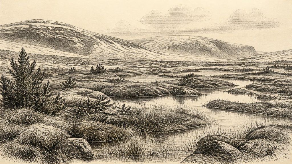
The biological remains recovered from the intervening sediments are unusually informative. Pollen, plant macrofossils, mosses and insects point to open, treeless country under a periglacial regime. Grasses, sedges, herbs, juniper and cold-adapted plants occurred, with freshwater mosses and pools in wetter ground. The assemblage has often been described as tundra or muskeg-like: waterlogged, mossy and sedgy terrain, with shallow open water and organic-rich margins. That description is an interpretation based on several lines of evidence, rather than a claim that Derryvree precisely matched any modern Arctic environment.
It was not the familiar wooded Ireland of later millennia. There is no basis for imagining oak woods, hazel scrub, cultivated clearings or permanent pasture. A short growing season, frost action, strong winds and thin or unstable soils would have constrained vegetation. Yet the presence of freshwater sediments and plant remains is equally important: this was not necessarily an unbroken expanse of snow or bare ice. In favourable hollows, water persisted long enough for a wetland community to form and leave a record.
Climate on an Unsteady Margin
MIS 3 was marked across the North Atlantic region by abrupt climatic shifts. Irish evidence from Crag Cave in County Kerry independently shows episodes when calcite formations could grow, requiring liquid water to pass through the cave and conditions less severe than sustained ground freezing. Such cave records support the broader conclusion that the last Ice Age was not climatically uniform. Derryvree belongs to this unsettled world: locally ice-free ground and freshwater existed, but under markedly cold conditions and within a longer history of expanding and returning ice.
It would be misleading, however, to turn Derryvree into a weather report for every Irish region. Fermanagh’s drumlin country, limestone caves in Munster, Atlantic coasts and uplands had different topographies and local conditions. Nor can the exact footprint of ice over Ireland be reconstructed for 31,010 BCE alone. Larger studies of the British–Irish Ice Sheet show that ice growth, flow and retreat varied between sectors, while much of the detailed chronology becomes firmer only later, nearer the Last Glacial Maximum. The safest conclusion is regional: at least parts of northern Ireland had experienced cold, non-glacial conditions before renewed glaciation buried the Derryvree wetland.
Castlepook’s Animal Archive
Castlepook Cave offers a contrasting, southern window onto the same broad age. The cave’s old excavations recovered more than 2,000 bones from a complicated deposit repeatedly affected by carnivores, water movement and early excavation practice. Direct dates on individual bones now indicate that the cave accumulated animal remains over a long stretch of the middle and late Ice Age, rather than representing one moment or one intact living community. Geological Survey Ireland identifies it as Ireland’s richest site for vertebrate fauna preceding the Last Glacial Maximum.
The dated fauna includes woolly mammoth, giant deer, reindeer, brown bear and spotted hyaena; later material includes Arctic fox, wolf and lemmings. These species do not all need have lived side by side at 31,010 BCE, and their presence in a cave does not mean the cave was a simple habitation site. Nevertheless, the assemblage demonstrates that parts of Ireland could support large herbivores and predators during portions of MIS 3. Reindeer and giant deer imply grazing or browsing opportunities in open landscapes; hyaenas and wolves point to predator and scavenger relationships; mammoth remains underline how different this Ice Age fauna was from Ireland’s later historic fauna.
Castlepook has also prompted discussion of a reindeer femur bearing a mark interpreted by some investigators as possible stone-tool damage from carcass processing. That suggestion is potentially important, but it remains insufficient evidence for a settled human population or a securely documented hunting camp in Ireland at this date. The bone’s age, the origin of its surface mark and the disturbed history of the cave deposit are separate questions. A solitary possible modification cannot establish how many people were present, whether they arrived once or repeatedly, what route they used, or whether they remained in Ireland for any length of time.
No Polities, No Settlements
There is no evidence from Ireland around this horizon for political communities, chiefs, territories, diplomacy, warfare, trade networks, houses, hearths, burials or monuments. It would be anachronistic to supply them merely because contemporary Upper Palaeolithic populations elsewhere in Europe made sophisticated stone tools and art. Those wider European comparisons help frame possibilities, but they are not evidence for an Irish society. No named people, languages, ethnic identities or religious beliefs can responsibly be attached to Derryvree or Castlepook at 31,010 BCE.
If people did briefly reach Ireland during this broad period, their most plausible activities would have been mobile and practical: moving through an exposed cold landscape, observing animal movements, seeking sheltered ground, and perhaps processing a carcass. Even that is an inference, not a demonstrated account. There is no securely dated Irish camp assemblage from this age to reveal toolkits, seasonal movement, food-sharing, clothing, kinship or exchange. The first unambiguous evidence for sustained human settlement in Ireland belongs much later, after the harshest phases of the last glaciation.
Deep History, Narrow Evidence
The importance of this date lies not in an invented episode but in what a few difficult records preserve. Derryvree shows a cold, wet, locally ice-free Fermanagh landscape existing between glacial advances. Castlepook records the presence, over a broad span, of mammals adapted to open Ice Age environments and the complex processes by which bones entered a cave. Crag Cave shows that climatic amelioration occurred episodically in south-west Ireland. Together they reveal an Ireland whose geography, ecology and habitability changed sharply long before later human communities arrived.
The historical lesson is therefore one of restraint as well as discovery. Around 31,010 BCE, Ireland has no recoverable political history in the ordinary sense. Its history is environmental and archaeological: meltwater settling into a basin, mosses and sedges growing at a pool edge, animals crossing open country, and later ice sealing or eroding the evidence. Those traces are fragmentary, but they are real. They provide a more compelling account than false precision: an island-region repeatedly reshaped by climate, with life persisting in the intervals that the ice did not erase.
Primary Sources
- Early Midlandian–Middle Midlandian, Pleistocene, Northern Ireland
- A Middle Midlandian Freshwater Series at Derryvree, Maguiresbridge, County Fermanagh, Northern Ireland
- Middle Midlandian Interstadial Deposits at Greenagho, Near Belcoo, County Fermanagh, Northern Ireland
- A Reconsideration of the Radiocarbon Dating of the Marine Isotope Stage 3 Fauna from Southern Ireland
- Castlepook Cave: County Geological Site Report
- The Exploration of Castlepook Cave, Co. Cork. With 3 Plates
- The Irish Quaternary Fauna Project
- Occurrence of Mammalia Relicts at Site Castlepook Cave
- New Insights on the Fauna of Ireland’s Younger Dryas and Early Holocene from Alice & Gwendoline Cave
- Episodic Speleothem Deposition Tracks the Terrestrial Impact of Millennial-Scale Last Glacial Climate Variability in SW Ireland
- Growth and Retreat of the Last British–Irish Ice Sheet, 31,000 to 15,000 Years Ago: the BRITICE-CHRONO Reconstruction
- The Timing and Magnitude of the British–Irish Ice Sheet Between Marine Isotope Stages 5d and 2
- Trimlines, Blockfields and the Vertical Extent of the Last Ice Sheet in Southern Ireland
- The IntCal20 Northern Hemisphere Radiocarbon Age Calibration Curve (0–55 cal kBP)
- IntCal Publications
- The Subdivision of the Quaternary Period in Ireland
- The Colonization of Ireland: A Human Ecology Perspective
- First Evidence of a Late Upper Palaeolithic Human Presence in Ireland
- Heritage Artefacts of County Cork
- 2022:564 – Castlepook Cave, Castlepook South, Cork