
Hyaena Land’s Faunal Network31664 BCE
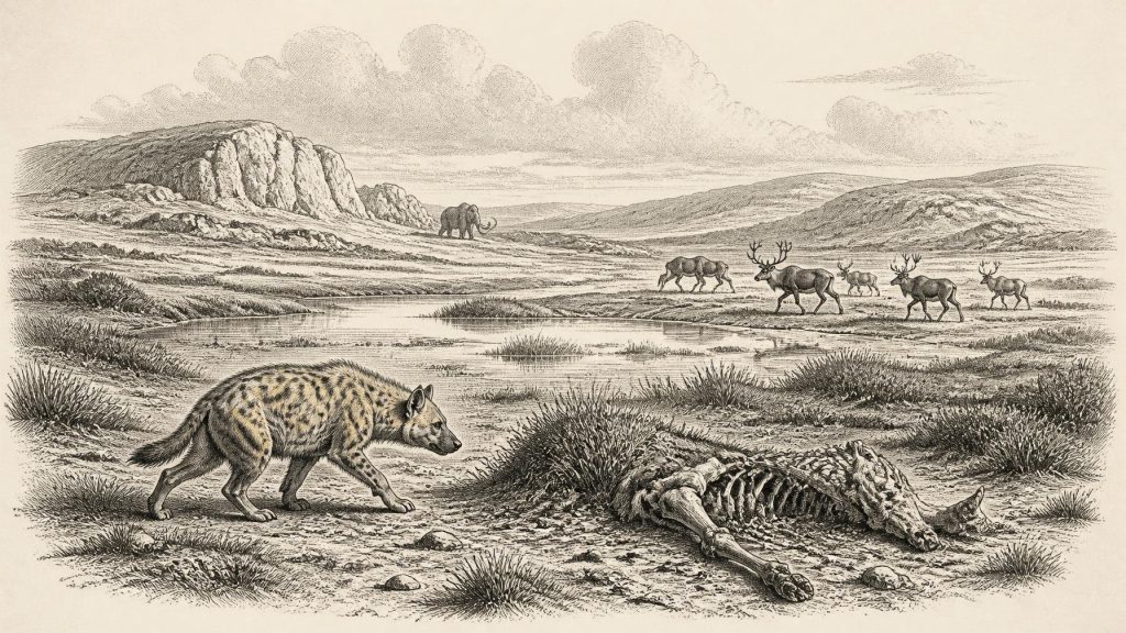
31,664 BCE is a modern label for a late Marine Isotope Stage 3 horizon, not a datable Irish event. Environmental evidence from Derryvree and Crag Cave indicates fluctuating cold conditions, open tundra wetlands and episodically milder intervals. Castlepook Cave preserves a diverse, time-mixed pre-Last Glacial Maximum fauna, including mammoth, reindeer, giant deer, hyaena, wolves and lemmings, demonstrating ecological links with north-west Europe. Ancient DNA may extend this picture, though remains provisional. A marked reindeer femur may indicate Upper Palaeolithic butchery, but cannot prove settlement. Ireland lacked communities or institutions; human visits remain uncertain amid changing ice, sea routes and landscapes.
Dateline
The label 31,664 BCE is a modern calendrical convenience, not a date that can be matched to a recorded Irish event, season or generation. No written calendar existed, and the surviving evidence cannot be resolved to a single year. In conventional radiocarbon terms it falls roughly 33,600 years before 1950; the responsible chronological setting is the later part of the Last Glacial period, within Marine Isotope Stage 3 (MIS 3), rather than a precise historical year. For Ireland, this is an archaeological and environmental horizon known through cave bones, buried sediments, pollen, insects, cave mineral deposits and the changing geography of ice and sea.
That distinction matters. Ireland at this depth of time was not the wooded island of later prehistory, nor a country with identifiable peoples, leaders or territories. It lay on the north-western fringe of Europe during an interval of abrupt climatic oscillation. The great ice expansion known as the Last Glacial Maximum still lay ahead, but conditions could alter sharply over centuries and millennia. The evidence permits a picture of changing cold-country ecosystems and perhaps very occasional human presence. It does not permit an account of an Irish polity, a battle, a diplomatic relationship or a settled national population.
A Shifting Cold-Stage Landscape
MIS 3 lasted broadly from about 57,000 to 29,000 years ago. It was not a single unbroken freeze. Greenland ice-core sequences reveal repeated swings between colder stadials and relatively milder interstadials, changes reflected in Irish cave deposits and sedimentary archives. At Crag Cave in County Kerry, uranium-thorium dating shows that calcite formed episodically during this wider period. Because shallow caves normally require liquid water rather than persistently frozen ground for such mineral growth, the deposits provide evidence for intervals in which mean annual conditions were less severe than in full glacial phases. They do not, however, give a weather report for 31,664 BCE itself.
The best terrestrial environmental comparison comes from Derryvree near Maguiresbridge in County Fermanagh. Organic-rich freshwater silts, sealed between separate glacial tills, produced calibrated ages of approximately 36.9–31.7 thousand calendar years before present. The span includes the broad time denoted by this article’s date, although it is far too wide to identify one particular year. Pollen, plant remains and insects from the deposit indicate an open, cold landscape, with wet ground, mosses, sedges and pools rather than closed forest. The insect evidence has been interpreted as a muskeg-like wetland rich in decaying plant matter, set within tundra or steppe-tundra conditions.
Such places were locally productive despite their severity. Open water and saturated ground could support aquatic plants, sedges and mosses; surrounding grass- and herb-rich ground could feed herbivores during favourable seasons. Yet winters were harsh, trees sparse or absent, and permafrost or seasonally frozen ground may have constrained drainage and vegetation. Ireland’s regional environments would not all have been identical. Lowlands, limestone karst, uplands, river valleys and coastal margins reacted differently to cold, snow, meltwater and changing ice margins. The scattered record captures fragments of these environments rather than a complete island-wide map.
Castlepook and the Animals
For the southern part of the island, Castlepook Cave near Doneraile in north County Cork is the key site. Older excavations recovered an exceptionally varied collection of Ice Age animal bones from several cave passages, including the aptly named Hyaena Land and Elephant Hall. Modern re-dating has shown that some Castlepook material is substantially older than earlier measurements indicated. Research now places elements of the pre-Last Glacial Maximum fauna across a long range, rather than treating the cave’s collection as a single event or a single living community.
The relevant fauna includes reindeer, woolly mammoth, giant deer, brown bear, wolf, Arctic fox, mountain hare, collared lemming, Norwegian lemming and spotted hyaena. This is powerful evidence that Ireland was intermittently part of a wider north-west European ecological network before the Last Glacial Maximum. It was not an isolated refuge inhabited solely by a few hardy species. Recent sedimentary ancient-DNA work at Castlepook has also detected a wider set of taxa and identified genetic links between Irish mammoths and hyaenas and populations elsewhere in Eurasia. As this genetic study is presently a preprint, its detailed conclusions should remain provisional; its central value is to demonstrate the potential of undisturbed cave sediments to supplement the old bone collections.
These animals should not be imagined together in one crowded scene. Bones entered caves over long periods, and different species may have used the landscape in different seasons or climatic phases. Carnivores could carry carcass parts underground; animals could die naturally in or near caves; water and sediment could move remains; and antiquarian excavation disturbed original layers. A cave assemblage is therefore an archive with several formation histories. It can establish that animals reached Ireland, but it rarely tells us where a herd grazed on a particular day or whether a hyaena, wolf or person brought a particular bone into a chamber.
Nevertheless, the animal record allows careful inferences about everyday ecological pressures. Reindeer were adapted to mobile life in open northern landscapes. Mammoths and giant deer imply substantial seasonal plant resources, while lemmings and Arctic foxes point to cold conditions. Spotted hyaenas, known in Ireland most securely from Castlepook, were formidable social predators and scavengers. Their presence is especially important because hyaena activity may explain why bones accumulated in caves. The landscape around Doneraile was therefore not empty wilderness but an active food web, in which grazers, browsers, predators and scavengers moved through a changing mosaic of open ground, wet places and limestone shelter.
The Reindeer Femur Question
A single object gives this period unusual archaeological importance: a reindeer femur from Castlepook. It has been publicly dated to about 31,000 BCE and bears a deep mark that zooarchaeologist Ruth Carden interprets as having been made with a sharp stone implement during carcass processing. If this interpretation is confirmed, it would indicate that a person or small group handled a reindeer in Ireland during the Upper Palaeolithic, far earlier than the long-established record of post-glacial settlement. The possibility is significant precisely because Irish evidence for people at this time is so scarce.
But the qualifications are inseparable from the claim. The femur comes from an old cave collection, not from a modern excavation of an intact occupation floor. No securely associated stone-tool assemblage, hearth, dwelling, grave, ornament, art panel or repeated food-processing area of comparable age has been recovered at Castlepook. A radiocarbon determination dates the animal’s death, not automatically the moment of marking, the place of killing or the identity of whoever made the mark. Nor can one modified bone establish whether visitors crossed during a single favourable episode, returned seasonally, lived nearby for years, or left descendants.
It is therefore safest to describe the femur as possible evidence of Upper Palaeolithic butchery, not proof of permanent settlement. The distinction is more than cautious wording. A travelling hunting party could have visited an accessible edge of Ireland, processed an animal, and disappeared from the archaeological record. Conversely, natural damage and the complicated history of cave deposits demand continuing microscopic and contextual scrutiny. Renewed excavation at Castlepook in 2022 located surviving cave sediments and identified areas of potential, offering a route by which future work may test the older interpretations more securely.
People Without a Political Record
There is no evidence from Ireland around this horizon for named communities, borders, chiefs, councils, warfare or diplomacy. It would be misleading to project later tribal or national identities backwards into a time before any demonstrated continuous human population on the island. If the Castlepook mark records human action, the makers were almost certainly mobile Upper Palaeolithic hunter-gatherers belonging to wider social worlds in Britain or continental north-west Europe. That is an interpretation based on comparative archaeology, not an excavated Irish camp.
Across Europe, groups of this broad era used carefully made stone tools, depended on extensive social connections, and in some regions created personal ornaments, imagery and cave art. None of those cultural practices has yet been securely demonstrated in Ireland at 31,664 BCE. Reindeer, if hunted or scavenged, could have supplied meat, marrow, hide, sinew and bone. Yet even that practical reconstruction exceeds what the femur alone proves: the mark cannot tell whether flesh was removed, tendons cut, hide detached or marrow sought. There is no Irish evidence at this date for farming, herding, metalworking, pottery, trade in finished goods, formal religious monuments or literacy.
The most meaningful ‘economy’ visible here is ecological movement. Faunal genetic connections and the presence of large mammals show that routes existed, intermittently, between Ireland and neighbouring parts of north-west Europe before the Last Glacial Maximum. Lower sea levels changed coastlines, but exact routes remain debated and should not be simplified into a guaranteed dry land bridge. Ice, exposed shelves, shallow water, temporary islands and coastal corridors could each have shaped access differently at different times. Animals demonstrably made the journey; human movement remains possible but poorly evidenced.
What This Date Can Mean
31,664 BCE thus marks neither an Irish founding moment nor an event that can be narrated year by year. It belongs to a broad, unstable interval in which Ireland supported cold-adapted mammals and patchy tundra wetlands before the maximum spread of the last ice sheet transformed much of the island. Derryvree provides the environmental frame; Crag Cave demonstrates millennial climatic variability; Castlepook supplies the most vivid faunal record and the tantalising reindeer femur. Together they show an Ireland connected to Ice Age Europe by ecology and geography, but not yet known through a settled human history. The evidence is thin, difficult and incomplete. Its importance lies in what it responsibly reveals: an inhabited animal landscape, a changing climate, and a still unresolved question over the earliest people to reach the island.
Primary Sources
- A Reconsideration of the Radiocarbon Dating of the Marine Isotope Stage 3 Fauna from Southern Ireland
- The Irish Quaternary Fauna Project
- A Middle Midlandian Freshwater Series at Derryvree, Maguiresbridge, County Fermanagh, Northern Ireland
- Episodic Speleothem Deposition Tracks the Terrestrial Impact of Millennial-Scale Last Glacial Climate Variability in SW Ireland
- Growth and Retreat of the Last British–Irish Ice Sheet, 31,000 to 15,000 Years Ago: The BRITICE-CHRONO Reconstruction
- Dimensions and Chronology of the Last Ice Sheet in Western Ireland
- Trimlines, Blockfields and the Vertical Extent of the Last Ice Sheet in Southern Ireland
- The Deglaciation of the Western Sector of the Irish Ice Sheet from the Inner Continental Shelf to its Terrestrial Margin
- Deglaciation, Earth Crustal Behaviour and Sea-Level Changes in the Determination of Insularity: A Perspective from Ireland
- The Island of Ireland: Drowning the Myth of an Irish Land-Bridge?
- Geology of Ireland
- Irish Quaternary Geomorphology Map Service
- Heritage Artefacts of County Cork
- 2022:564 – Castlepook Cave, Castlepook South, Cork
- Mammoth Cave / Castlepook Cave
- The Archaeology of Caves in Ireland
- First Evidence of a Late Upper Palaeolithic Human Presence in Ireland
- New Insights on the Fauna of Ireland’s Younger Dryas and Early Holocene from Alice and Gwendoline Cave
- Phylogeographic, Ancient DNA, Fossil and Morphometric Analyses Reveal Ancient and Modern Introductions of a Large Mammal: The Complex Case of Red Deer in Ireland
- Sedimentary Ancient DNA Reveals Late Pleistocene Faunal Connectivity Between Ireland and Eurasia