

Derryvree’s Hidden Sedge Marsh31216 BCE
About 31,216 BCE, Ireland lay within Marine Isotope Stage 3, a variable cold interval rather than a precisely dated historical moment. At Derryvree near Maguiresbridge, freshwater sediments preserved beneath later tills record treeless, waterlogged tundra of sedges, mosses, herbs and shallow pools. Castlepook Cave’s broad contemporary fauna included mammoth, reindeer, giant deer, hyaena, wolves and cold-adapted small mammals, though deposits accumulated over time. A marked reindeer femur may indicate human carcass processing around 33,000 years ago, but cannot prove settlement or sustained occupation. Dynamic glaciation, uncertain routes and regional environmental variation defined conditions there for much of this remote period.
Dateline
The label 31,216 BCE is useful to a modern chronology, but it must not imply an event recorded to that year. No calendar-year precision is available for Ireland this far into the Pleistocene. The most relevant evidence consists of deposits and animal remains dated across broad ranges. A Bayesian reconstruction places the Derryvree organic horizon near Maguiresbridge, County Fermanagh, at about 33.5 ± 1.2 thousand calibrated years before present: a range that encompasses this notional year, rather than pinpointing it. Ireland around this time belonged to the Middle Midlandian part of the last glacial cycle, conventionally correlated with Marine Isotope Stage 3. It was a changing cold-world landscape, not a named historical age with rulers, towns or chronicles.
A Date Within a Range
That distinction is fundamental. Radiocarbon years are not calendar years, because atmospheric carbon-14 has varied through time; very old results also carry substantial laboratory and calibration uncertainty. Derryvree’s famous determination, BIRM-166, was reported as 30,500 ± 1,100 radiocarbon years BP. Modern modelling treats it as evidence for an ice-free or lightly glaciated interval in its locality around 33.5 thousand calendar years BP, not as a dated day, season or human generation. The requested year therefore belongs within an archaeological and environmental window. It cannot responsibly be made the anniversary of a migration, a hunt or a climatic reversal.
The same caution applies to period names. Earlier Irish schemes termed this the Derryvree Cold Phase. That label remains useful as shorthand for a cold, open environment represented at Derryvree and linked, in older frameworks, with animal remains from Castlepook Cave in County Cork. Yet it does not mean that every part of Ireland experienced precisely the same weather, vegetation or ice cover at once. The island’s relief, coastlines, proximity to ice masses and Atlantic weather systems made local conditions variable. The larger British–Irish Ice Sheet was developing unevenly during this long interval and would attain its greatest later extent, broadly between about 26,000 and 20,000 years ago.
Evidence Beneath a Drumlin
Derryvree is important because later ice so often eroded, redeposited or buried Ireland’s older Pleistocene landscapes. In a road cutting through a drumlin near Maguiresbridge, investigators found freshwater silts, fine sands and organic sediments sandwiched between two tills: unsorted debris deposited by glacier ice. The sequence establishes a simple but powerful order of events. Ice had affected the district; afterwards, water and vegetation accumulated sediment in a non-glacial setting; later ice sealed that former landscape beneath another till. The locality is not a settlement site, but it is a rare environmental archive from close to 31,216 BCE.
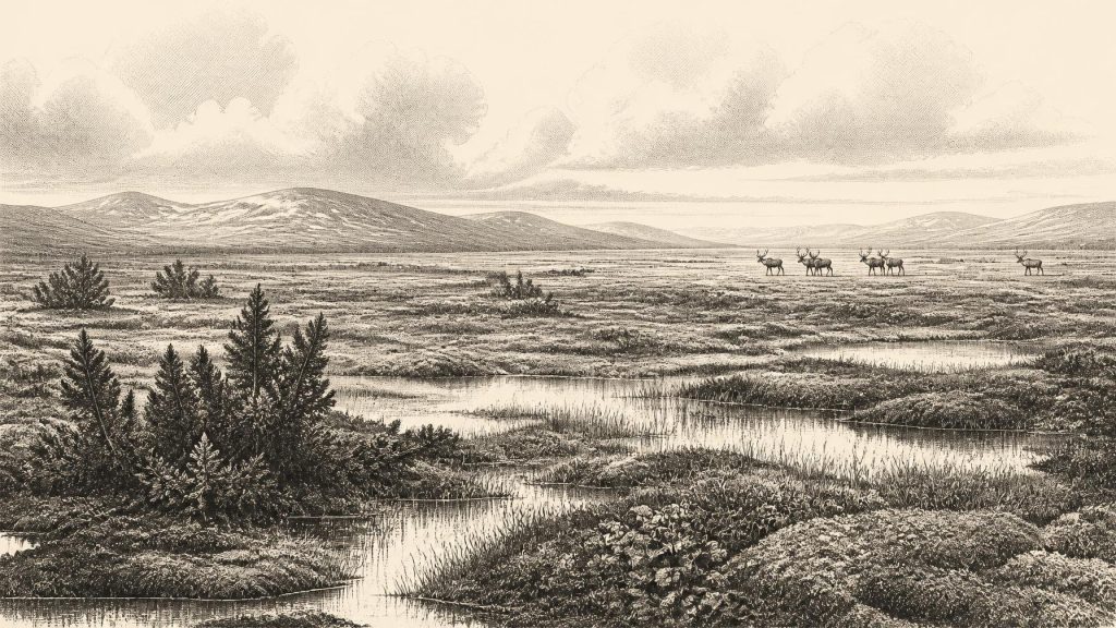
Its plant and insect remains indicate treeless tundra or muskeg: waterlogged ground with sedges, grasses, mosses and shallow pools, rather than woodland or peat bog in the modern Irish sense. Fossils include bogbean, lesser clubmoss and mountain-avens, plants able to survive exposed, cold conditions. Juniper and a variety of herbs are also represented in the wider reconstruction. Insects support the picture of wet, organic-rich ground and pools fringed by moss. This was not a featureless sheet of snow. During a suitable season, low plants, sedge margins and standing water created a patchwork of forage and shelter at ground level; in winter, however, the climate was severe.
The evidence describes a local habitat, not the whole island. It is nevertheless reasonable to infer a broadly open Irish landscape in many exposed areas, with far less tree cover than later Holocene Ireland. Permafrost-related processes, frost action, seasonal thaw and shifting drainage would have been central facts of life for plants and animals. The familiar patchwork of enclosed fields, hedges, deep peatlands and broad deciduous woods lay tens of millennia in the future. Many of the soils, gravels and landforms that shape modern Ireland would, however, be profoundly altered by the ice advances still to come.
Castlepook’s Animal World
In southern Ireland, Castlepook Cave near Doneraile, County Cork, offers the richest known Irish assemblage of vertebrates from this broad pre-Last Glacial Maximum world. Its cave deposits and historic collections have produced remains attributed to woolly mammoth, reindeer, giant deer, brown bear, wolf, foxes, mountain or Arctic hare, stoat, collared lemming, Norwegian lemming and spotted hyaena. Not every specimen need be exactly contemporary, and the cave’s early excavation history complicates reconstruction. Nevertheless, the assemblage demonstrates that Ireland could support a strikingly varied cold-stage fauna during parts of Marine Isotope Stage 3.
That fauna helps give Derryvree’s sedge marsh a living scale. Reindeer and giant deer could have used open vegetation and wetland edges; lemmings and hares belong to cold-adapted communities; wolves, bears and hyaenas reveal a food web with large carnivores and scavengers. Yet no one should turn this list into a painted panorama for a single day in 31,216 BCE. Animal bones accumulated over time, sometimes through carnivore activity, natural deaths and movement within caves. Their presence proves that species reached Ireland during the relevant broad period; it does not map an exact herd route or establish their numbers in a particular valley.
Caves themselves were not necessarily human homes. At Castlepook, hyaena remains and other carnivore evidence make clear that animals could use underground spaces, drag in food and alter bones. A cave collection is therefore an archive of ecological processes as much as a record of any one creature’s occupation. That is why modern re-dating, taphonomic study and carefully controlled excavation matter so greatly. They separate the securely observed—bone, species, surface mark, sedimentary context and laboratory age—from larger stories that remain possible but unproven.
The Human Question
The human question is the most arresting and the least settled aspect of this date. A reindeer femur from Castlepook has been interpreted by zooarchaeologist Ruth Carden as bearing a deep mark made on fresh bone by a sharp stone implement, perhaps during carcass processing. Direct dating and reassessment of the southern Irish fauna have made a human presence around 33,000 years ago a serious possibility. If the interpretation is upheld, it would move evidence of human activity in Ireland dramatically earlier than the terminal-Pleistocene butchered brown-bear bone from Alice and Gwendoline Cave, County Clare.
But a single marked bone cannot demonstrate a permanent settlement, a population, or even a camp. There is no securely associated hearth, stone-tool assemblage, house floor, burial, repeated butchery area or occupation surface at Castlepook of this age. Moreover, the femur comes from an old cave collection rather than a recently excavated sealed context. The date establishes the age of the animal bone; microscopic and taphonomic assessment must establish whether its mark is truly a human tool trace and whether it was made at the animal’s death. The responsible conclusion for 31,216 BCE is therefore conditional: people may have visited or processed an animal in Ireland during this broad period, but sustained human occupation has not been demonstrated.
No Polities, No Proven Camps
There is no evidence for political affairs, formal leadership, diplomacy, warfare, territorial states or named communities in Ireland at this time. It would be misleading to describe the movements of hyaenas, reindeer or ice as conflict between peoples. Nor is there evidence for trade, agriculture, herding, metalworking, pottery, monuments, writing or ritual practice. No recovered object permits a defensible account of religion, art, language, kinship rules or learning in Ireland around this date.
If people were present, their way of life may be compared only cautiously with Upper Palaeolithic hunter-gatherers elsewhere in north-west Europe: small, mobile groups capable of travelling through cold seasonal landscapes and obtaining meat, hides, bone and antler from large animals. That comparison is interpretation, not Irish proof. The Castlepook femur would indicate an act of carcass processing, not a social system. It cannot tell us whether the person who made the mark was alone or accompanied, whether they hunted the reindeer or found it dead, where they came from, or whether they ever returned.
Routes Across a Changing World
Ireland’s connection with neighbouring lands is equally uncertain. Lower global sea levels altered the Irish Sea basin, but lower water alone does not prove a walkable land bridge between Ireland and Britain. Geological work has challenged the older assumption of a dependable southern or central Irish Sea route, while allowing that changing islands, ice and sea conditions may have created complex northern possibilities at other times. For this early interval, there is no excavated Irish route, boat, crossing place or continental settlement trail linking a human visitor to Castlepook. Any account of migration must remain hypothetical.
Regional contrast matters more than imagined frontiers. Derryvree in Fermanagh preserves a freshwater tundra wetland beneath later glacial deposits. Castlepook in Cork preserves an animal-rich limestone-cave archive. Aghnadarragh in County Antrim supplies a longer stratigraphic sequence showing that Irish environments had repeatedly shifted between ice, cold open ground and milder intervals. Together these places reveal an Ireland that was environmentally dynamic, ecologically connected to wider north-west European faunas at times, and repeatedly transformed by glaciation.
What Can Be Said
For 31,216 BCE, the strongest story is not of a king, battle or settlement but of evidence preserved against remarkable odds. Near Maguiresbridge, sedges, mosses, aquatic plants and insects recorded a cold wetland during an interval later hidden beneath ice-borne debris. In Cork, caves retained traces of mammoths, reindeer, hyaenas and other animals from the same broad cold-stage world. A single reindeer bone may preserve a human action, but the claim awaits the fuller corroboration that an extraordinary revision of Irish prehistory requires.
That restraint does not diminish the period. It places Ireland within the deep environmental history from which its later landscapes emerged. Around this point in the Late Pleistocene, the island was neither an empty stage awaiting history nor a place whose human past can be confidently narrated. It was a cold, open and unstable land, inhabited certainly by a distinctive animal community, documented locally by wetland sediments, and possibly touched by people whose presence remains one of Irish archaeology’s most important unresolved questions.
Primary Sources
- A reconsideration of the radiocarbon dating of the Marine Isotope Stage 3 fauna from southern Ireland
- The Irish Quaternary Fauna Project
- Irish Pleistocene Biostratigraphy
- Exploring the controls on ice stream retreat during the last deglaciation of the British-Irish Ice Sheet
- Growth and retreat of the last British-Irish Ice Sheet, 31,000 to 15,000 years ago: the BRITICE-CHRONO reconstruction
- Timing, pace and controls on ice sheet retreat: an introduction to the BRITICE-CHRONO transect reconstructions of the British-Irish Ice Sheet
- The Problem of a Late Quaternary Landbridge Between Britain and Ireland
- Ireland: Submerged Prehistoric Sites and Landscapes
- The subdivision of the Quaternary Period in Ireland
- Quaternary Site Descriptions
- Castlepook Cave: County Geological Site Report
- Heritage Artefacts of County Cork
- New Insights on the Fauna of Ireland's Younger Dryas and Early Holocene from Alice & Gwendoline Cave
- Our Ancient Landscapes: Hunter-Gatherers in Ireland
- Ireland Through Geological Time
- Aghnadarragh ASSI
- Aghnadarragh
- Menyanthes trifoliata
- Selaginella selaginoides
- Dryas octopetala
- Pleistocene Vertebrates in the British Isles
- On the Discovery of Hyaena, Mammoth and Other Extinct Mammals in a Carboniferous Cavern in County Cork