
Limerick Origins(c.1160s)
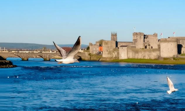
Limerick’s origins lie on King’s Island in the River Shannon where Norse settlers established a longstanding trading and naval base by the early tenth century. Archaeological excavations and contemporary medieval annals record a Viking presence around 922 when the island was known in Gaelic as Inis Sibhtonn. That foundation precedes many later Irish urban developments. The river position created a natural harbour and defensive advantage which attracted settlement, craft, markets and strategic interest from neighbouring Gaelic kings. Continuous occupation from the early medieval period underpins Limerick’s claim as one of Ireland’s oldest urban centres. Archaeology and records support this continuity.
Anglo‑Norman involvement reshaped Limerick from the late twelfth century, with ecclesiastical and royal foundations marking a new phase. St Mary’s Cathedral is recorded with foundation material and early endowments dated to 1168 in cathedral and diocesan registers. A royal charter confirming borough status and privileges was granted in 1197 and appears in chancery roll transcriptions preserved among Anglo‑Norman charter collections. Castle building and repair expenditure is documented in Pipe Rolls and Exchequer accounts for c.1200–1215, reflecting investment in fortifications. Archaeological fieldwork at King John’s Castle has identified Norse and medieval phases and provides material correlation with the documentary record firmly.
The river position fostered commercial activity recorded in medieval port accounts and customs rolls which note trade on the Shannon and tolls collected at the quays. Markets and craft production are attested in municipal records, guild rolls and council minutes preserving evidence of urban governance and legal privileges. Surviving burgage plot descriptions, early town maps and municipal cartularies document the street pattern and property tenures that shaped medieval Limerick’s urban form. These sources, combined with archaeological evidence, illuminate the interplay of riverine trade, civic organisation and property regimes in sustaining the town’s economy across the medieval and early modern periods.
Later cartographic and archaeological work reinforced understanding of Limerick’s medieval organisation. Contemporary six inch and first edition Ordnance Survey maps from the nineteenth century display historic street layouts, King’s Island and residual medieval features, providing a nineteenth‑century snapshot of an earlier urban plan. Excavation reports, including the King John’s Castle field report on Excavations.ie, detail Norse phases and surviving medieval masonry, linking stratified deposits to mapped features. Combined map evidence and targeted excavation enable researchers to trace continuity and change in building patterns, defensive works and waterfront alignment from the Viking period through Anglo‑Norman consolidation into later centuries and archaeologists.
Primary documentary series survive in local and national repositories, offering research leads across record types cited. Annals such as the Annals of Inisfallen and the Annals of the Four Masters record early activity, while cathedral registers and municipal cartularies preserve foundation, legal and property material. Port books, customs rolls, Pipe Rolls and chancery transcriptions document economic and royal engagements. Burgage rentals, guild rolls and council minutes outline urban governance. Researchers can consult six inch Ordnance Survey sheets and early maps alongside excavation reports to correlate documentary and material evidence, enabling a layered reconstruction of settlement history on King’s Island locally.
Primary Sources
- Annals of Inisfallen, entry recording Viking activity in the Shannon and references to Inis Sibhtonn (early medieval annal entry, c.10th century).
- Annals of the Four Masters, relevant entries for settlement and raids on Limerick, tenth to twelfth centuries (manuscript and printed editions in national collections).
- Foundation record and medieval registers for St Mary’s Cathedral, Limerick, noting foundation date 1168 and early endowments (cathedral archives and diocesan registers).
- Royal charter of Limerick, granted in 1197 (charter recorded in contemporary royal chancery rolls; copy and transcriptions held in national Anglo Norman charter collections).
- Pipe Rolls and Exchequer accounts recording building and repair expenditure on Limerick’s castle and defences, c.1200–1215 (English royal financial records held at The National Archives, Kew).
- Excavation report: King John’s Castle, St Mary’s Parish, Limerick (archaeological field report published on Excavations.ie, detailing Norse phases and medieval masonry). Source Link
- Medieval burgage plots and town plan evidence recorded in Limerick municipal cartularies and early town maps (manuscript maps and burgage rentals in local and national archives).
- Medieval port accounts and customs rolls for Limerick, recording trade on the Shannon and tolls collected at the quays (port books and customs accounts, archival series in national repositories).
- Contemporary six inch and first edition Ordnance Survey maps showing historic street layout, King’s Island and medieval features (Ordnance Survey Ireland map series, 19th century lithographs and originals in map collections).
- Series of municipal records, guild rolls and council minutes from medieval and early modern Limerick showing urban governance, markets and legal privileges (Limerick City and County archives and national manuscript collections).