
Derryvree’s Bogbean Season31435 BCE
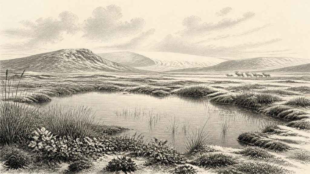
Around 31,435 BCE, Ireland lay within the variable Midlandian cold stage, not a precisely reconstructable single year. Derryvree, County Fermanagh, preserves freshwater organic sediments between glacial tills, radiocarbon-dated broadly to 36,900–31,700 cal BP. Its bogbean, sedges, mosses and aquatic plants indicate treeless wet tundra with seasonal liquid water, rather than permanent ice or temperate woodland. Comparable deposits show changing local climates and ice limits. Cave fauna demonstrate that reindeer, mammoth, giant deer and predators occurred during overlapping Late Pleistocene phases, but not necessarily together. No securely dated human activity exists. Later ice expansion buried Derryvree and erased many older landscapes.
Dateline
The label 31,435 BCE creates a false impression of precision. Nothing in Ireland’s archaeological or environmental record can identify conditions in one calendar year so remote from the present: there are no written sources, annual chronicles, dated settlements or human burials for this point. Expressed in the archaeological convention of years before AD 1950, it falls at roughly 33,384 calibrated years before present (cal BP), within the later part of Marine Isotope Stage 3, a highly variable interval of the last Ice Age. The responsible approach is therefore to examine broad, calibrated date ranges and the physical traces that overlap them, rather than inventing an event for a particular year.
A Window Within the Ice Age
Ireland at this time was not yet the familiar Atlantic island of wooded valleys, fields and coasts. Sea level was substantially lower because immense volumes of water were stored in continental ice sheets. The Irish Sea was narrower and its surrounding shelves exposed or shallow in ways that altered the geography of movement. Yet lower sea level did not automatically make a single continuous land bridge from Ireland to continental Europe. The precise configuration of coasts, water, seasonal sea ice and ice margins changed repeatedly, and isostatic movements complicated any simple map.
The period belongs to the Midlandian, the Irish name commonly used for the last cold-stage sequence. It was not an unbroken age of universal ice cover. Across the North Atlantic world, abrupt climatic shifts alternated between comparatively milder interstadials and severe stadials. Ireland’s surviving deposits indicate that glaciers advanced and retreated regionally, while open ground, wetlands and animal habitats could exist in some areas during intervals that preceded the Last Glacial Maximum. The latter, reached much later, was devastating for the preservation of older landscapes: moving ice eroded soils, redistributed sediment and removed much of the evidence through which a pre-maximum human presence might otherwise be recognised.
The Derryvree Evidence
The most informative Irish evidence for this broad time window comes from Derryvree near Maguiresbridge in County Fermanagh. There, excavation exposed organic-rich freshwater silts and sands lying between two tills: deposits left by glaciers. The sequence establishes an important relative order. An earlier ice advance laid down the lower till; subsequently, an ice-free local basin held water long enough for sediment, plants and small animals to accumulate; later glacier ice buried the deposit beneath another till. It is a rare survival of an Irish landscape that existed between glacial episodes.
A conventional radiocarbon determination from the Derryvree organic series, BIRM-166, was published as about 30,500 ± 1,100 radiocarbon years BP. A radiocarbon age is not itself a calendar age, because atmospheric carbon-14 concentrations have varied considerably through time. When treated through modern calibration, the result corresponds only to a broad span, approximately 36,900–31,700 cal BP. The numerical date represented by 31,435 BCE lies within that wide interval. This does not show that every Derryvree plant, pool or insect lived in that exact year; it makes the deposit a relevant environmental archive for the period.
Its biological remains point to cold, open conditions. The deposit has been interpreted as a treeless muskeg or wet tundra environment, with sedges, mosses and aquatic or waterside plants occupying shallow freshwater ground. Finds associated with bogbean, water-milfoil and other moisture-loving taxa show that this was not a sterile plain of permanent ice. There was liquid water for at least part of the year, vegetation capable of producing organic sediment, and a mosaic of saturated ground, pools and more exposed surfaces. Plant fossils are direct evidence of organisms represented in, or washed into, the deposit. Reconstructing the wider landscape from them is interpretation, necessarily limited by local topography, transport and preservation.
Cold Ground, Living Water
The Derryvree assemblage is especially valuable because it corrects two misleading extremes. Ireland was neither a temperate woodland refuge nor necessarily a land entirely locked beneath ice. The vegetation indicates a rigorous periglacial setting, likely with long winters, short growing seasons and limited woody cover. Frost action would have disturbed bare ground, while snowmelt and seasonal runoff fed pools and channels. The word “tundra” is useful only if it conveys this patchwork: wet hollows, sedge-rich margins, mossy areas and drier mineral surfaces, rather than one uniform carpet of plants.
Comparable northern Irish sequences broaden the picture without providing an identical contemporary scene. At Greenagho in County Fermanagh, organic deposits beneath till indicate another episode in which water and vegetation occupied ground later overridden by ice. Aghnadarragh in County Antrim preserves a far longer and more complex succession, including evidence for an earlier, cooler-temperate interval with trees, swamp and pools, followed by colder treeless deposits. These sites demonstrate that Irish climate and ice extent altered significantly across the wider Midlandian. They should not be compressed into one simultaneous landscape. Their real value is to show why a date such as 31,435 BCE must be treated as part of a fluctuating environmental sequence.
Mammals on a Changing Island
Cave finds from southern Ireland provide a second, very different body of evidence. Castlepook Cave near Doneraile, County Cork, and other cave sites have yielded remains attributed to mammals including reindeer, giant deer, mammoth, spotted hyaena, bears, foxes and lemmings. Radiocarbon programmes showed that a range of mammals entered or survived in Ireland before the Last Glacial Maximum, with many relevant dates falling broadly between 45,000 and 20,000 radiocarbon years BP. The fauna confirms that Ireland could support substantial animals during parts of the Late Pleistocene and that it was connected ecologically to neighbouring north-west Europe.
But cave bone collections are not a census of one landscape. Many were excavated in the late nineteenth or early twentieth centuries, before modern recording standards, and their deposits could be disturbed by water, roof collapse, carnivores and later digging. At Castlepook, bones of markedly different ages occurred in different parts of the cave, and some accumulations probably resulted from animals or bones falling through fissures rather than from a single occupation surface. A mammoth bone in a cave proves mammoths reached Ireland at some stage; it does not prove that a herd grazed beside the Derryvree pool in 31,435 BCE.
Still, the combined faunal record suggests an open-country ecosystem of considerable variety. Reindeer and lemmings suit cold conditions; mammoth and giant deer imply sufficient forage across broad landscapes; hyaenas and wolves, where present, signal food webs capable of sustaining large predators or scavengers. Animal movements probably followed changing corridors of available land, coastal shelf and ice. Such movements need not have been one dramatic invasion. They may instead have been repeated, partial colonisations and local disappearances as habitat, snow cover, sea level and glacier margins changed.
No Demonstrated Community
There is no securely dated human settlement from Ireland at this time. No hearth, stone-tool assemblage, dwelling floor, burial, food-processing area or artwork can presently be assigned to around 33,384 cal BP. Consequently there is no evidence for Irish political authority, diplomacy, warfare, named communities, social hierarchy, religious practice, formal learning, trade networks or a settled domestic economy in 31,435 BCE. These are not merely gaps in the written record; they are categories for which the archaeological evidence has not been found.
It is possible that people made occasional incursions into lands now forming Ireland during the wider Upper Palaeolithic. Low sea levels and the presence of large mammals made this geographically conceivable, while later glaciation offers a strong explanation for why shallow camps may have been destroyed. Possibility, however, is not proof. Ireland’s earliest published direct evidence for human activity is vastly later: cut marks on a brown-bear patella from Alice and Gwendoline Cave, County Clare, dated to roughly 12,810–12,590 cal BP. That find documents a final-Palaeolithic human incursion, not an occupation thirty thousand years earlier.
Society Beyond the Horizon
Elsewhere in Europe, people of the Upper Palaeolithic made sophisticated stone and organic tools, travelled across wide territories, hunted and scavenged varied animals, used pigments and created striking forms of visual culture. None of this should simply be transferred to Ireland. Continental or British parallels establish what human groups of the era were capable of; they do not establish that such groups lived here, nor that particular social practices crossed the Irish Sea.
The most defensible social history for Ireland is therefore an environmental one. The land was shaped by ice, frost, water and sparse vegetation. Its inhabitants demonstrably included plants, insects and, during overlapping phases, a changing suite of mammals. Pools at Derryvree supported wetland life; open terrain elsewhere could sustain grazing animals and carnivores. Whether humans ever watched, hunted or crossed these landscapes remains unresolved. The silence is historically meaningful: it distinguishes a richly recoverable Ice-Age ecology from a human past that remains, for this date, beyond secure demonstration.
Regional Change Ahead
Over the following millennia, climatic deterioration and growth of the British–Irish Ice Sheet would transform Ireland again. By the Last Glacial Maximum, much or all of the island was ice-covered, and that renewed glaciation scoured away innumerable older surfaces. Derryvree survived precisely because its freshwater sediments were sealed beneath till. Its bogbean-bearing wetland is thus not an ordinary site but an exceptional archive: a brief, locally preserved record of life between ice advances.
For 31,435 BCE, Ireland’s story is not one of kings, migrations or monuments. It is the story of a cold, intermittently habitable Pleistocene landscape, reconstructed from sediments and fossils whose dates span centuries or millennia. Derryvree gives the clearest image: shallow freshwater among tundra vegetation, preserved below the debris of a later glacier. That modest deposit supplies firmer historical ground than any invented event could offer.
Primary Sources
- A Middle Midlandian Freshwater Series at Derryvree, Maguiresbridge, County Fermanagh, Northern Ireland
- The Irish Quaternary Fauna Project
- The Irish Quaternary Fauna Project
- First Evidence of a Late Upper Palaeolithic Human Presence in Ireland
- First Evidence of a Late Upper Palaeolithic Human Presence in Ireland
- New Insights on the Fauna of Ireland’s Younger Dryas and Early Holocene from Alice & Gwendoline Cave
- Ireland: Submerged Prehistoric Sites and Landscapes
- The IntCal20 Northern Hemisphere Radiocarbon Age Calibration Curve (0–55 cal kBP)
- IntCal Publications
- Figure 6: The Subdivision of the Quaternary Period in Ireland
- References and Recommended Reading: Irish Quaternary Association Field Guide
- Aghnadarragh Earth Science Conservation Review Site
- Aghnadarragh ESCR Site Summary
- Mammoth and Musk Ox ESR-Dated to the Early Midlandian at Aghnadarragh, County Antrim, Northern Ireland, and the Age of the Fermanagh Stadial
- Mammoth and Musk Ox ESR-Dated to the Early Midlandian at Aghnadarragh
- The Timing and Magnitude of the British–Irish Ice Sheet Between Marine Isotope Stages 5d and 2
- Late Pleistocene Chronostratigraphy and Ice Sheet Limits, Southern Ireland
- Landscapes and Environments of the Last Glacial-Interglacial Transition: A Time of Amazingly Rapid Change in Ireland
- The Mesolithic in Ireland: When Was It?
- Ireland’s Palaeolithic Archaeology: Fleeting Footprints in a Frozen Land
- Ireland’s First Settlers: Time and the Mesolithic
- The Geological Heritage of County Leitrim